Statewide Context for Local Street Design
•Download as PPT, PDF•
1 like•501 views
Presentation of Matthew Crall, land use and transportation planner with Oregon's Department of Land Conservation and Development, at CNU's Emergency Response and Narrower Streets Workshop, Nov. 3, 2009, in Portland, Ore.
Report
Share
Report
Share
![[object Object],[object Object],[object Object],[object Object],History](data:image/gif;base64,R0lGODlhAQABAIAAAAAAAP///yH5BAEAAAAALAAAAAABAAEAAAIBRAA7)
Recommended
Highway Mixed Use District Presentation 20090727
Highway Mixed Use District presentation presented by Marsh Darcy to Joint Workshop (Council and PD&Z) for the City of Manvel.
Fairfax County Land Use February 2014
The document describes Fairfax County, Virginia's process for developing land use and land cover data layers for watershed management plans. It involved grouping existing land use codes into 11 categories, assigning categories to tax and parcel data, and using aerial imagery to estimate impervious surfaces. The resulting data provided information on existing and future land use and imperviousness at the sub-basin level to support water quality and hydrologic modeling.
Lbdc 081013
This document provides an overview and strategic framework for the Louis Botha Avenue corridor in Johannesburg from 1938 to 2013. It discusses the history and development of the corridor over time. The strategic framework establishes a vision to promote connectivity, protect mixed-use economic zones, optimize social infrastructure, and drive sustainable densification along the corridor. It identifies priority intervention areas and preliminary projects through 2030 to implement the vision. Challenges to implementation include aligning different project streams to the common vision and dealing with reluctance to change.
One code final presentation 8 18_10
OneCode is an effort to consolidate Dania Beach's three separate zoning codes into a single unified code. It aims to make the code more user-friendly without changing residents' existing lifestyles or development potential. City staff hosted multiple community workshops to gather input on topics like boat lifts, sheds, fences, and vehicle parking. The proposed OneCode defines commercial vehicle regulations and allows limited parking of small commercial vehicles in residential areas.
Route 28 Widening: Citizens Information Meeting - April 3, 2018
This document provides information from a citizens meeting about plans to widen Route 28 in Fairfax County from 6 to potentially 8 lanes. It summarizes the project background and purpose, completed studies on traffic, environment, and right-of-way needs. Preliminary design and cost estimates were presented for 6, 7, and 8 lane options, with a hybrid 6-7-8 lane configuration as the preferred option based on initial traffic analysis. Both traditional design-bid-build and accelerated design-build delivery methods were discussed, along with potential project schedules under each approach. Citizen feedback was solicited on the proposed widening project.
ATS-16: Connecting the Dots: Trails and Transportation, Buff Brown
Case studies on the policy, planning, funding, and design considerations that create great networks where trails seamlessly link to streets and transit.
Presenter:
Buff Brown
TOD Redevelopment on the Grandest Scale by Tom Young
Redevelopment of older neighborhoods, brownfields and sprawling suburban areas is a reality across North America. These projects provide exciting test cases for large-scale TOD and integrated land use planning. Explore three large-scale TOD redevelopment projects that are transforming their communities. Hear about innovative sustainable development approaches being deployed: complete streets, reduced commercial and residential parking, custom zoning and integrated stormwater management. Study the design of high-quality public realms including urban agriculture areas, parks and open spaces. Take home tangible strategies for balancing the needs of a sustainable, multimodal transportation network with the needs of redevelopment.
Moderator: Steve Granson, Transit Project Manager, HDR, Chicago, Illinois
Katherine Youngbluth, AICP, Commercial Development Specialist, Real Estate Development Group, Arlington County Government, Arlington, Virginia
Tom Young, AICP, Associate - Community Development, Stantec Consulting Ltd., Edmonton, Alberta
Merrill St. Leger-Demian, AICP, LEED AP, Principal, SmithGroup/JJR, Washington, DC
David Kirschner, Capital Projects Management Coordinator, Environmental Services, Arlington County, Arlington, Virginia
Planning for a sustainable and affordable cape cod
Planning for a sustainable and affordable cape codSouthern New England American Planning Association
The document summarizes a presentation about planning for a sustainable and affordable Cape Cod region. It discusses the historic economy and development patterns on Cape Cod, challenges around continued sprawl, and the role of the Cape Cod Commission in regional planning. It then outlines an approach using map-based planning and geodesign principles to develop a regional land use vision map. This map aims to focus future growth into activity centers with community amenities, businesses, and compact built forms to make development more sustainable and affordable.Recommended
Highway Mixed Use District Presentation 20090727
Highway Mixed Use District presentation presented by Marsh Darcy to Joint Workshop (Council and PD&Z) for the City of Manvel.
Fairfax County Land Use February 2014
The document describes Fairfax County, Virginia's process for developing land use and land cover data layers for watershed management plans. It involved grouping existing land use codes into 11 categories, assigning categories to tax and parcel data, and using aerial imagery to estimate impervious surfaces. The resulting data provided information on existing and future land use and imperviousness at the sub-basin level to support water quality and hydrologic modeling.
Lbdc 081013
This document provides an overview and strategic framework for the Louis Botha Avenue corridor in Johannesburg from 1938 to 2013. It discusses the history and development of the corridor over time. The strategic framework establishes a vision to promote connectivity, protect mixed-use economic zones, optimize social infrastructure, and drive sustainable densification along the corridor. It identifies priority intervention areas and preliminary projects through 2030 to implement the vision. Challenges to implementation include aligning different project streams to the common vision and dealing with reluctance to change.
One code final presentation 8 18_10
OneCode is an effort to consolidate Dania Beach's three separate zoning codes into a single unified code. It aims to make the code more user-friendly without changing residents' existing lifestyles or development potential. City staff hosted multiple community workshops to gather input on topics like boat lifts, sheds, fences, and vehicle parking. The proposed OneCode defines commercial vehicle regulations and allows limited parking of small commercial vehicles in residential areas.
Route 28 Widening: Citizens Information Meeting - April 3, 2018
This document provides information from a citizens meeting about plans to widen Route 28 in Fairfax County from 6 to potentially 8 lanes. It summarizes the project background and purpose, completed studies on traffic, environment, and right-of-way needs. Preliminary design and cost estimates were presented for 6, 7, and 8 lane options, with a hybrid 6-7-8 lane configuration as the preferred option based on initial traffic analysis. Both traditional design-bid-build and accelerated design-build delivery methods were discussed, along with potential project schedules under each approach. Citizen feedback was solicited on the proposed widening project.
ATS-16: Connecting the Dots: Trails and Transportation, Buff Brown
Case studies on the policy, planning, funding, and design considerations that create great networks where trails seamlessly link to streets and transit.
Presenter:
Buff Brown
TOD Redevelopment on the Grandest Scale by Tom Young
Redevelopment of older neighborhoods, brownfields and sprawling suburban areas is a reality across North America. These projects provide exciting test cases for large-scale TOD and integrated land use planning. Explore three large-scale TOD redevelopment projects that are transforming their communities. Hear about innovative sustainable development approaches being deployed: complete streets, reduced commercial and residential parking, custom zoning and integrated stormwater management. Study the design of high-quality public realms including urban agriculture areas, parks and open spaces. Take home tangible strategies for balancing the needs of a sustainable, multimodal transportation network with the needs of redevelopment.
Moderator: Steve Granson, Transit Project Manager, HDR, Chicago, Illinois
Katherine Youngbluth, AICP, Commercial Development Specialist, Real Estate Development Group, Arlington County Government, Arlington, Virginia
Tom Young, AICP, Associate - Community Development, Stantec Consulting Ltd., Edmonton, Alberta
Merrill St. Leger-Demian, AICP, LEED AP, Principal, SmithGroup/JJR, Washington, DC
David Kirschner, Capital Projects Management Coordinator, Environmental Services, Arlington County, Arlington, Virginia
Planning for a sustainable and affordable cape cod
Planning for a sustainable and affordable cape codSouthern New England American Planning Association
The document summarizes a presentation about planning for a sustainable and affordable Cape Cod region. It discusses the historic economy and development patterns on Cape Cod, challenges around continued sprawl, and the role of the Cape Cod Commission in regional planning. It then outlines an approach using map-based planning and geodesign principles to develop a regional land use vision map. This map aims to focus future growth into activity centers with community amenities, businesses, and compact built forms to make development more sustainable and affordable.Css class 18 placemaking 120309
Lesson 18 for Grad Course on CSS (from UTCM Report #08-14-03 "Making Mobility Improvements a Community Asset: Transportation Improvements Using Context-Sensitive Solutions")
COMPLETE STREETS in FRANKLIN, WI
The document discusses the history and purpose of Safe Routes to School (SRTS), a federal program established in 2005 to encourage children to safely walk and bike to school. It then focuses on Franklin's involvement with SRTS, including receiving grants to fund a walking workshop, planning assistance, and public information meetings to assess issues and develop a SRTS plan. The goal is to further engage the community and eventually apply for infrastructure grants to implement the plan.
Css class 17 multimodal options 112309
Lesson 17 for Grad Course on CSS (from UTCM Report #08-14-03 "Making Mobility Improvements a Community Asset: Transportation Improvements Using Context-Sensitive Solutions")
Css class 26 using css in practice 113009
Lesson 26 for Grad Course on CSS (from UTCM Report #08-14-03 "Making Mobility Improvements a Community Asset: Transportation Improvements Using Context-Sensitive Solutions")
Interactive Design of Urban Spaces using Geometrical and Behavioral Modeling
Presentation slides.
Carlos A. Vanegas, Daniel G. Aliaga, Bedrich Benes, Paul Waddell, “Interactive Design of Urban Spaces using Geometrical and Behavioral Modeling”, ACM Transactions on Graphics (Proceedings SIGGRAPH Asia), 28(5), 2009.
Optimizing The User Experience Through Integrated Information Design
Presented at DocTrain East 2007 Conference by Sowmini Sampath & Richard Ellis, MathWorks -- What roles do technical writers play when designing and implementing the user assistance for complex applications? In this session we discuss the development of an integrated system of user assistance for an application used by computational systems biologists. We found that the process required the technical writer to assume roles that ranged from Information Architect to Interaction Designer to Usability Specialist.
What You Will Learn in this Session
In this session, we share:
* An information architecture that delivers information in the context of the user’s task, even as users escalate their quest for information beyond context sensitive help
* An interaction model in which help responds to user action by providing a clear set of steps to follow from one state to another
* A process that technical writers can use to design integrated help solutions for their applications.
Presentation1
This document discusses the classification of highways in India based on various factors such as weather conditions, carriageway type, traffic volume, location, and function. It outlines the different categories of national highways, state highways, major district roads, other district roads, and village roads. It also describes the classification of urban roads as expressways, arterial roads, sub-arterial roads, collector roads, and local streets. Common road design standards and specifications are provided for each type.
Street Design Guidelines
The poor quality of our streets causes over 160 deaths every year. There is a dire need for street design guidelines that ensure high quality streets through standardization of essential street elements
Improving Street Design Through 'Link and Place'
This presentation was delivered by Peter Jones from University College London on 2nd October 2015 and highlighted the importance of considering Link and Place when improving street design.
Css slide template 111609
Context sensitive solutions aim to balance transportation safety, mobility, and environmental goals by involving stakeholders early and throughout the planning process. Transportation projects are designed to complement their surrounding communities and consider all users of the transportation system. Community and environmental concerns are addressed through collaborative decision making between transportation officials, residents, and interested parties.
Css classes 27 28 - term project presentations 100410
Lessons 27-28 for Grad Course on CSS (from UTCM Report #08-14-03 "Making Mobility Improvements a Community Asset: Transportation Improvements Using Context-Sensitive Solutions")
Syllabus css course - 10 weeks 022309
This course focuses on context sensitive solutions (CSS) as applied to transportation planning, environmental analysis, and design. The course will cover CSS concepts and applications through lectures, discussions, readings and a class project. Students will learn how to build consensus and design transportation facilities that are compatible with their surrounding context. Grades will be based on assignments, class participation, exams, and a group class project applying CSS to a transportation design.
Complete Streets, Complete Places
The characteristics of complete streets and complete street networks. How completes streets create complete places
Street Design guidelines UTTIPEC 2011-printer-friendly
The document provides street design guidelines for equitable distribution of road space in Delhi, India. It was originally called the Pedestrian Design Guidelines but was later renamed to Street Design Guidelines to incorporate additional design elements. The guidelines were created based on best practices from around the world and customized for India. They include 10 mandatory street design components and additional design guidelines.
Manual for streets 2
This document provides an overview of sustainable transport solutions and the principles of Manual for Streets (MfS). It discusses the wider application of MfS beyond residential streets, comparing it to the Design Manual for Roads and Bridges (DMRB). The document outlines the key principles of MfS, including placing an emphasis on pedestrians and balancing traffic needs. It also discusses quality audits, street typologies, shared space, and addressing concerns around liability for innovative designs.
Roadspace Allocation for Better Streets
This presentation highlights the importance of Roadspace Allocation within transport planning and illustrates how to develop a successful Roadspace Allocation Framework. Further to this the presentation gives an insight to understanding and meeting user requirements. It then progresses to utilise various case studies in Birmingham to further demonstrate how these frameworks can be put into practice.
Road types and Road networks
Road networks are the primary mode of transportation and divide land into patterns to provide paths between destinations. They can be classified based on speed and accessibility. Urban roads include expressways for speedy traffic between major areas, arterial streets for heavy traffic within cities, sub-arterial streets with less traffic, collector streets that funnel traffic to arterials, and local streets for neighborhood access. Common urban road patterns are grid iron networks with perpendicular streets, radial networks with ring roads and radiating streets, and organic patterns that develop irregularly based on needs.
Functional Classification of Streets: So important that no one wants to talk ...
This presentation was given as an online seminar sponsored by American Planning Association's New Urbanism Division. The audio is available on YouTube: http://youtu.be/J9HjJ78Ma7w
As practitioners of new urbanism principles, it is important to understand why our street networks have eroded so dramatically and the direct connection to livability and sustainability that we strive to achieve. The purpose of the webcast will educate participants to strengthen their transportation planning knowledge base. That knowledge will increase productivity of the collaboration between engineers and planners.
Functional classification is a transportation topic that is often left for engineers to sort out, but it has a huge impact on urban planning. Anyone involved in urban planning – including community stakeholders – should be part of the dialogue surrounding the function of public streets. Functional classification is a way that transportation professionals group streets according to the type of traffic they serve and the degree of access expected to adjacent land uses.
Few transportation issues are as important as functional classification, and yet it is one of the least understood or debated. Despite the Federal Highway Administration’s advocacy of flexible design standards, typical practice in the United States has been very rigid, leading to unintended negative consequences. For new urbanism, that means streets that require almost highway speeds and lane widths—physical impacts that are contrary to the overall purpose of new urban planning. For example, in some areas an Urban Principal Arterial might require a minimum 45 MPH design speed and minimum 12-foot wide lanes, even if the surrounding land uses need more appropriate (i.e. livable, sustainable) solutions.
The session includes two primary takeaways: (1) history of streets (vitality, walkability, etc.); and (2) how we can learn from our history to improve streets (including mobility and safety for all users). Designing places scaled appropriately for active human living is critical, especially in urbanized areas (city centers, suburbs, villages, etc.).
Road Design Manual 1.3
This document provides guidelines for designing urban roads. It outlines the key objectives of road design including safety, ease of navigation, smooth traffic flow, aesthetics, and optimal space utilization. The document recommends listing all potential uses of the road, including vehicles, pedestrians, bicycles, street furniture, utilities, etc. It suggests defining requirements for each use based on user needs and industry standards. A checklist should incorporate all requirements. Standard design templates can then be created for different road classifications to promote consistency. The systematic approach aims to produce well-designed, safe roads that improve quality of life.
UTTIPEC STREET DESIGN GUIDELINES
Download the Official Version of this Document from the UTTIPEC Website at the Link below: http://uttipec.nic.in/StreetGuidelines-R1-Feb2011-UTTPEC-DDA.pdf
Munson Avenue Traffic Calming
This document discusses the history of traffic issues and measures taken on Munson Street in College Station, Texas. It notes that in 1998-1999, various traffic calming measures were tested but residents later passed an ordinance prohibiting them by a 2 to 1 margin. Recent traffic counts from 2019-2020 show speeds remain around 33 mph. The transportation committee now recommends repealing the ordinance to allow consideration of traffic calming according to city policy.
T16 addressing pavement assest management-galehouse
T16 addressing pavement assest management-galehouseAPWA Florida Chapter 2013 Annual Meeting and Trade Show
This document discusses pavement preservation strategies and treatments. It provides details on various preservation techniques including crack sealing, thin overlays and microsurfacing. It compares the life cycle costs of traditional reconstruction versus a preservation approach. A preservation approach that utilizes low-cost preventative maintenance treatments can extend pavement life, resulting in lower long-term costs when compared to traditional reconstruction. The timing and selection of the right treatment is important to address pavement distresses cost effectively and ensure the overall network needs are met.More Related Content
Viewers also liked
Css class 18 placemaking 120309
Lesson 18 for Grad Course on CSS (from UTCM Report #08-14-03 "Making Mobility Improvements a Community Asset: Transportation Improvements Using Context-Sensitive Solutions")
COMPLETE STREETS in FRANKLIN, WI
The document discusses the history and purpose of Safe Routes to School (SRTS), a federal program established in 2005 to encourage children to safely walk and bike to school. It then focuses on Franklin's involvement with SRTS, including receiving grants to fund a walking workshop, planning assistance, and public information meetings to assess issues and develop a SRTS plan. The goal is to further engage the community and eventually apply for infrastructure grants to implement the plan.
Css class 17 multimodal options 112309
Lesson 17 for Grad Course on CSS (from UTCM Report #08-14-03 "Making Mobility Improvements a Community Asset: Transportation Improvements Using Context-Sensitive Solutions")
Css class 26 using css in practice 113009
Lesson 26 for Grad Course on CSS (from UTCM Report #08-14-03 "Making Mobility Improvements a Community Asset: Transportation Improvements Using Context-Sensitive Solutions")
Interactive Design of Urban Spaces using Geometrical and Behavioral Modeling
Presentation slides.
Carlos A. Vanegas, Daniel G. Aliaga, Bedrich Benes, Paul Waddell, “Interactive Design of Urban Spaces using Geometrical and Behavioral Modeling”, ACM Transactions on Graphics (Proceedings SIGGRAPH Asia), 28(5), 2009.
Optimizing The User Experience Through Integrated Information Design
Presented at DocTrain East 2007 Conference by Sowmini Sampath & Richard Ellis, MathWorks -- What roles do technical writers play when designing and implementing the user assistance for complex applications? In this session we discuss the development of an integrated system of user assistance for an application used by computational systems biologists. We found that the process required the technical writer to assume roles that ranged from Information Architect to Interaction Designer to Usability Specialist.
What You Will Learn in this Session
In this session, we share:
* An information architecture that delivers information in the context of the user’s task, even as users escalate their quest for information beyond context sensitive help
* An interaction model in which help responds to user action by providing a clear set of steps to follow from one state to another
* A process that technical writers can use to design integrated help solutions for their applications.
Presentation1
This document discusses the classification of highways in India based on various factors such as weather conditions, carriageway type, traffic volume, location, and function. It outlines the different categories of national highways, state highways, major district roads, other district roads, and village roads. It also describes the classification of urban roads as expressways, arterial roads, sub-arterial roads, collector roads, and local streets. Common road design standards and specifications are provided for each type.
Street Design Guidelines
The poor quality of our streets causes over 160 deaths every year. There is a dire need for street design guidelines that ensure high quality streets through standardization of essential street elements
Improving Street Design Through 'Link and Place'
This presentation was delivered by Peter Jones from University College London on 2nd October 2015 and highlighted the importance of considering Link and Place when improving street design.
Css slide template 111609
Context sensitive solutions aim to balance transportation safety, mobility, and environmental goals by involving stakeholders early and throughout the planning process. Transportation projects are designed to complement their surrounding communities and consider all users of the transportation system. Community and environmental concerns are addressed through collaborative decision making between transportation officials, residents, and interested parties.
Css classes 27 28 - term project presentations 100410
Lessons 27-28 for Grad Course on CSS (from UTCM Report #08-14-03 "Making Mobility Improvements a Community Asset: Transportation Improvements Using Context-Sensitive Solutions")
Syllabus css course - 10 weeks 022309
This course focuses on context sensitive solutions (CSS) as applied to transportation planning, environmental analysis, and design. The course will cover CSS concepts and applications through lectures, discussions, readings and a class project. Students will learn how to build consensus and design transportation facilities that are compatible with their surrounding context. Grades will be based on assignments, class participation, exams, and a group class project applying CSS to a transportation design.
Complete Streets, Complete Places
The characteristics of complete streets and complete street networks. How completes streets create complete places
Street Design guidelines UTTIPEC 2011-printer-friendly
The document provides street design guidelines for equitable distribution of road space in Delhi, India. It was originally called the Pedestrian Design Guidelines but was later renamed to Street Design Guidelines to incorporate additional design elements. The guidelines were created based on best practices from around the world and customized for India. They include 10 mandatory street design components and additional design guidelines.
Manual for streets 2
This document provides an overview of sustainable transport solutions and the principles of Manual for Streets (MfS). It discusses the wider application of MfS beyond residential streets, comparing it to the Design Manual for Roads and Bridges (DMRB). The document outlines the key principles of MfS, including placing an emphasis on pedestrians and balancing traffic needs. It also discusses quality audits, street typologies, shared space, and addressing concerns around liability for innovative designs.
Roadspace Allocation for Better Streets
This presentation highlights the importance of Roadspace Allocation within transport planning and illustrates how to develop a successful Roadspace Allocation Framework. Further to this the presentation gives an insight to understanding and meeting user requirements. It then progresses to utilise various case studies in Birmingham to further demonstrate how these frameworks can be put into practice.
Road types and Road networks
Road networks are the primary mode of transportation and divide land into patterns to provide paths between destinations. They can be classified based on speed and accessibility. Urban roads include expressways for speedy traffic between major areas, arterial streets for heavy traffic within cities, sub-arterial streets with less traffic, collector streets that funnel traffic to arterials, and local streets for neighborhood access. Common urban road patterns are grid iron networks with perpendicular streets, radial networks with ring roads and radiating streets, and organic patterns that develop irregularly based on needs.
Functional Classification of Streets: So important that no one wants to talk ...
This presentation was given as an online seminar sponsored by American Planning Association's New Urbanism Division. The audio is available on YouTube: http://youtu.be/J9HjJ78Ma7w
As practitioners of new urbanism principles, it is important to understand why our street networks have eroded so dramatically and the direct connection to livability and sustainability that we strive to achieve. The purpose of the webcast will educate participants to strengthen their transportation planning knowledge base. That knowledge will increase productivity of the collaboration between engineers and planners.
Functional classification is a transportation topic that is often left for engineers to sort out, but it has a huge impact on urban planning. Anyone involved in urban planning – including community stakeholders – should be part of the dialogue surrounding the function of public streets. Functional classification is a way that transportation professionals group streets according to the type of traffic they serve and the degree of access expected to adjacent land uses.
Few transportation issues are as important as functional classification, and yet it is one of the least understood or debated. Despite the Federal Highway Administration’s advocacy of flexible design standards, typical practice in the United States has been very rigid, leading to unintended negative consequences. For new urbanism, that means streets that require almost highway speeds and lane widths—physical impacts that are contrary to the overall purpose of new urban planning. For example, in some areas an Urban Principal Arterial might require a minimum 45 MPH design speed and minimum 12-foot wide lanes, even if the surrounding land uses need more appropriate (i.e. livable, sustainable) solutions.
The session includes two primary takeaways: (1) history of streets (vitality, walkability, etc.); and (2) how we can learn from our history to improve streets (including mobility and safety for all users). Designing places scaled appropriately for active human living is critical, especially in urbanized areas (city centers, suburbs, villages, etc.).
Road Design Manual 1.3
This document provides guidelines for designing urban roads. It outlines the key objectives of road design including safety, ease of navigation, smooth traffic flow, aesthetics, and optimal space utilization. The document recommends listing all potential uses of the road, including vehicles, pedestrians, bicycles, street furniture, utilities, etc. It suggests defining requirements for each use based on user needs and industry standards. A checklist should incorporate all requirements. Standard design templates can then be created for different road classifications to promote consistency. The systematic approach aims to produce well-designed, safe roads that improve quality of life.
UTTIPEC STREET DESIGN GUIDELINES
Download the Official Version of this Document from the UTTIPEC Website at the Link below: http://uttipec.nic.in/StreetGuidelines-R1-Feb2011-UTTPEC-DDA.pdf
Viewers also liked (20)
Interactive Design of Urban Spaces using Geometrical and Behavioral Modeling
Interactive Design of Urban Spaces using Geometrical and Behavioral Modeling
Optimizing The User Experience Through Integrated Information Design
Optimizing The User Experience Through Integrated Information Design
Css classes 27 28 - term project presentations 100410
Css classes 27 28 - term project presentations 100410
Street Design guidelines UTTIPEC 2011-printer-friendly
Street Design guidelines UTTIPEC 2011-printer-friendly
Functional Classification of Streets: So important that no one wants to talk ...
Functional Classification of Streets: So important that no one wants to talk ...
Similar to Statewide Context for Local Street Design
Munson Avenue Traffic Calming
This document discusses the history of traffic issues and measures taken on Munson Street in College Station, Texas. It notes that in 1998-1999, various traffic calming measures were tested but residents later passed an ordinance prohibiting them by a 2 to 1 margin. Recent traffic counts from 2019-2020 show speeds remain around 33 mph. The transportation committee now recommends repealing the ordinance to allow consideration of traffic calming according to city policy.
T16 addressing pavement assest management-galehouse
T16 addressing pavement assest management-galehouseAPWA Florida Chapter 2013 Annual Meeting and Trade Show
This document discusses pavement preservation strategies and treatments. It provides details on various preservation techniques including crack sealing, thin overlays and microsurfacing. It compares the life cycle costs of traditional reconstruction versus a preservation approach. A preservation approach that utilizes low-cost preventative maintenance treatments can extend pavement life, resulting in lower long-term costs when compared to traditional reconstruction. The timing and selection of the right treatment is important to address pavement distresses cost effectively and ensure the overall network needs are met.#41 Times Change, People Change, Transportation Needs Change - LaPlante
#41 Times Change, People Change, Transportation Needs Change - LaPlanteProject for Public Spaces & National Center for Biking and Walking
This document summarizes a presentation by John LaPlante on committing a lifetime to active transportation. Some key points from the presentation include debunking common traffic engineering myths such as the idea that slower speeds reduce mobility, and that spending on complete streets is a luxury. The presentation also discusses the costs of retrofitting urban arterials to be more pedestrian and bicycle friendly through traffic calming measures and improved pedestrian infrastructure and signals. It aims to show that these improvements can often be achieved at low cost and provide community benefits like safer streets.Roads and Pavements
This document provides statistics and information about roads and pavements in Kirklees, including:
- Over 32,000 highway openings are made each year for repairs and maintenance.
- It costs up to £1,000,000 to repair a bridge and £800 per square meter for a retaining wall.
- Residents expect roads and pavements to be well-maintained with smooth surfaces and that any repairs will be carried out thoroughly.
Roads and Pavements
This document provides statistics and information about roads and pavements in Kirklees, including:
- Over 32,000 highway openings are made each year for repairs and maintenance.
- It costs up to £1,000,000 to repair a bridge and £800 per square meter for a retaining wall.
- Residents expect roads and pavements to be well-maintained with smooth surfaces and that any repairs will be carried out thoroughly.
roads and pavements
This document provides statistics and information about roads and pavements in Kirklees, including:
- Over 32,000 highway openings are made each year for repairs and maintenance.
- It costs up to £1,000,000 to repair a bridge and £800 per square meter for a retaining wall.
- Residents expect roads and pavements to be well-maintained with smooth surfaces and that any repairs will be carried out thoroughly.
UDO Amendments for Traffic Impact Analysis
The document discusses proposed amendments to the city's Unified Development Ordinance regarding traffic impact analysis requirements. It would require traffic impact analyses for single family residential developments based on acreage thresholds. It also proposes a preliminary plan requirement and updated trip generation rates table. Public meetings were held in March and April to discuss the changes, with a presentation and vote by the Planning and Zoning Commission and City Council scheduled for August.
5 (1)
This document outlines design standards for a highway project. It discusses standards for road capacity, geometric design, intersections, bridges and culverts, pavements, and other road elements. The standards are sourced from Indian Road Congress codes and Ministry of Road Transport & Highways guidelines. Tables summarizing the adopted standards are presented for various elements, including minimum median widths, carriageway widths, shoulder widths, slopes, sight distances, and more. Pavement designs will follow IRC standards and consider a 20-year performance period. Bridge and culvert designs will be based on the latest IRC and IS codes.
Traffic Control By Brian Kidd
This document provides an overview and summary of changes to the Australian Standard AS1742.3-2009 for traffic control related to works on roads. Some key points:
- The standard was updated after a 4-year review process involving various industry and government stakeholders.
- Changes include new signs, clarification of sign sizes, revisions to provisions for short-term low impact works, and new requirements for safety audits and risk management.
- Mobile work convoys and temporary speed zones must now be used for all works involving workers on foot.
- Guidance is provided for emergency works, excavation protection, and consistency across jurisdictions through an Austroads review.
Public Workshop #3
- The document summarizes Public Workshop Meeting #3 that was held on December 8, 2010 to discuss proposals for a transportation corridor project.
- It provides an agenda for the meeting that includes a project update, overview of technical memos, work session to evaluate concepts, and public comments.
- The project goals are outlined, including addressing congestion, serving population growth, and improving mobility.
- 18 unique corridor alignment concepts and 18 unique streetscape cross-section concepts were developed.
- Feedback was gathered from meeting attendees to help narrow the concepts down to 5 of each for further review by the project team.
- The next steps are to review feedback and have the project team meet to select concepts to
Public Workshop #3
- The document summarizes Public Workshop Meeting #3 that was held on December 8, 2010 to discuss proposals for improving the 172nd Avenue corridor.
- It provides an agenda, project updates, and summaries of technical memos addressing transportation conditions, design standards, and development of alignment and streetscape concepts.
- 18 unique corridor alignment concepts and 18 unique streetscape cross-section concepts were developed and evaluated. Feedback was gathered to narrow the concepts down to 5 of each for further review.
- The goal of the meeting was to get public input to help recommend a preliminary concept for further development and evaluation by the Project Management Team.
TSRGD Roadshow 9 35am and 9-45am graham hanson [compatibility mode]
The document discusses a review of traffic sign regulations in the UK. It notes that the current regulations are outdated, do not allow for innovation, and place a large administrative burden on local authorities. The review aims to take a more flexible approach by simplifying and deregulating some existing rules. A survey of local authorities found support for greater national consistency but also more flexibility through relaxed regulations and guidance rather than mandates. Key changes proposed include reducing the number of prescribed signs, giving local authorities more discretion over placement and design of signs, and simplifying the regulations into tables and menus to reduce complexity.
Open house boards, June 11, 2015
The document summarizes a public open house meeting for a transit study evaluating options to improve transit between Amherst and Buffalo, New York. It discusses the study process and screening of alternatives through three tiers. In Tier 2 screening, light rail and bus rapid transit alternatives were evaluated on criteria like ridership, environmental impacts, and engineering needs. Based on this, one light rail and three bus rapid transit alternatives were proposed to advance to more detailed Tier 3 analysis to identify a preferred alternative. Community feedback on the proposals was solicited. The schedule for completing Tier 3 analysis and selecting a preferred option was also outlined.
Open houseboards
This document summarizes a public open house meeting for a transit study between Amherst and Buffalo, New York. It presented the study process, alternatives being considered, and results of screening so far. Light rail transit and bus rapid transit alternatives on Niagara Falls Boulevard and Bailey Avenue were identified to advance to further analysis in the next phase of the study. The meeting provided information on the alternatives and sought public input to help identify a locally preferred alternative for the corridor by fall 2015.
Public Workshop #2
This document summarizes Public Workshop #2 that was held in October 2010 to discuss corridor design for a new transportation project. The meeting agenda covered why the project was needed due to expected population growth and congestion. It discussed corridor alignment and streetscape goals, including improving mobility while minimizing environmental impacts. The document provided an overview of roadway design basics like horizontal and vertical alignment, cross-sections, and intersections. It also reviewed opportunities and constraints identified through stakeholder interviews and existing conditions reports. Attendees were asked to provide feedback on potential new corridor alignments using a roadway design tool.
Traffic Calming In Fort Worth
The document discusses traffic calming measures that can be implemented through Fort Worth's Neighborhood Traffic Management Program. It describes the process for developing a neighborhood traffic plan, including obtaining neighborhood and city approval. It also lists various traffic calming devices and their purposes, such as speed humps, chicanes, and traffic circles, which are intended to reduce vehicle speeds and improve safety for non-motorists.
Randy Iwasaki: Quiet pavements
Hear the latest on research and practical applications to reduce traffic noise through the implementation of smooth and quieter pavement designs, thereby mitigating the impact of transportation systems on nearby communities.
Off-Street Parking Standards
This document discusses proposed amendments to the city's off-street parking requirements. It provides an outline of prior discussions and presentations with the Planning and Zoning Commission on parking flexibility. The Commission voted to recommend approval of draft ordinance amendments. The proposed amendments aim to provide more flexibility and reduce barriers to development. They include adjusting parking minimums and purpose statements, increasing eligibility for shared/off-site parking, exempting small sites from some requirements, and allowing more administrator discretion. The staff recommendation is to approve the nine proposed ordinance revisions.
Complete Streets Cnu Conf (Jun09)Gaye
This document discusses Colorado Springs' adoption of a complete streets policy and its implementation. It summarizes how the policy was initiated and approved through a citizen transportation committee and various stakeholders. It then outlines how the city has implemented the policy through capital projects that accommodate all users, retrofitting existing roads, adding bike lanes and sidewalks, and new street design standards. It provides examples of roadway projects and their effects on safety and speed. It also discusses lessons learned around community support, balancing policy and flexibility, and taking an opportunistic approach to retrofits.
Port Orange Mobility Plan Fpza Presentation 2009
Describes the future mobility plan for the City of Port Orange in response to 2009 state legislation requiring the City to adopt mobility and sustainability strategies, taking advantage of the City\'s designation as a TCEA (Transportation Concurrency Exception Area).
Similar to Statewide Context for Local Street Design (20)
T16 addressing pavement assest management-galehouse
T16 addressing pavement assest management-galehouse
#41 Times Change, People Change, Transportation Needs Change - LaPlante
#41 Times Change, People Change, Transportation Needs Change - LaPlante
TSRGD Roadshow 9 35am and 9-45am graham hanson [compatibility mode]
TSRGD Roadshow 9 35am and 9-45am graham hanson [compatibility mode]
Recently uploaded
Taking AI to the Next Level in Manufacturing.pdf
Read Taking AI to the Next Level in Manufacturing to gain insights on AI adoption in the manufacturing industry, such as:
1. How quickly AI is being implemented in manufacturing.
2. Which barriers stand in the way of AI adoption.
3. How data quality and governance form the backbone of AI.
4. Organizational processes and structures that may inhibit effective AI adoption.
6. Ideas and approaches to help build your organization's AI strategy.
TrustArc Webinar - 2024 Global Privacy Survey
How does your privacy program stack up against your peers? What challenges are privacy teams tackling and prioritizing in 2024?
In the fifth annual Global Privacy Benchmarks Survey, we asked over 1,800 global privacy professionals and business executives to share their perspectives on the current state of privacy inside and outside of their organizations. This year’s report focused on emerging areas of importance for privacy and compliance professionals, including considerations and implications of Artificial Intelligence (AI) technologies, building brand trust, and different approaches for achieving higher privacy competence scores.
See how organizational priorities and strategic approaches to data security and privacy are evolving around the globe.
This webinar will review:
- The top 10 privacy insights from the fifth annual Global Privacy Benchmarks Survey
- The top challenges for privacy leaders, practitioners, and organizations in 2024
- Key themes to consider in developing and maintaining your privacy program
Digital Marketing Trends in 2024 | Guide for Staying Ahead
https://www.wask.co/ebooks/digital-marketing-trends-in-2024
Feeling lost in the digital marketing whirlwind of 2024? Technology is changing, consumer habits are evolving, and staying ahead of the curve feels like a never-ending pursuit. This e-book is your compass. Dive into actionable insights to handle the complexities of modern marketing. From hyper-personalization to the power of user-generated content, learn how to build long-term relationships with your audience and unlock the secrets to success in the ever-shifting digital landscape.
HCL Notes und Domino Lizenzkostenreduzierung in der Welt von DLAU
Webinar Recording: https://www.panagenda.com/webinars/hcl-notes-und-domino-lizenzkostenreduzierung-in-der-welt-von-dlau/
DLAU und die Lizenzen nach dem CCB- und CCX-Modell sind für viele in der HCL-Community seit letztem Jahr ein heißes Thema. Als Notes- oder Domino-Kunde haben Sie vielleicht mit unerwartet hohen Benutzerzahlen und Lizenzgebühren zu kämpfen. Sie fragen sich vielleicht, wie diese neue Art der Lizenzierung funktioniert und welchen Nutzen sie Ihnen bringt. Vor allem wollen Sie sicherlich Ihr Budget einhalten und Kosten sparen, wo immer möglich. Das verstehen wir und wir möchten Ihnen dabei helfen!
Wir erklären Ihnen, wie Sie häufige Konfigurationsprobleme lösen können, die dazu führen können, dass mehr Benutzer gezählt werden als nötig, und wie Sie überflüssige oder ungenutzte Konten identifizieren und entfernen können, um Geld zu sparen. Es gibt auch einige Ansätze, die zu unnötigen Ausgaben führen können, z. B. wenn ein Personendokument anstelle eines Mail-Ins für geteilte Mailboxen verwendet wird. Wir zeigen Ihnen solche Fälle und deren Lösungen. Und natürlich erklären wir Ihnen das neue Lizenzmodell.
Nehmen Sie an diesem Webinar teil, bei dem HCL-Ambassador Marc Thomas und Gastredner Franz Walder Ihnen diese neue Welt näherbringen. Es vermittelt Ihnen die Tools und das Know-how, um den Überblick zu bewahren. Sie werden in der Lage sein, Ihre Kosten durch eine optimierte Domino-Konfiguration zu reduzieren und auch in Zukunft gering zu halten.
Diese Themen werden behandelt
- Reduzierung der Lizenzkosten durch Auffinden und Beheben von Fehlkonfigurationen und überflüssigen Konten
- Wie funktionieren CCB- und CCX-Lizenzen wirklich?
- Verstehen des DLAU-Tools und wie man es am besten nutzt
- Tipps für häufige Problembereiche, wie z. B. Team-Postfächer, Funktions-/Testbenutzer usw.
- Praxisbeispiele und Best Practices zum sofortigen Umsetzen
Presentation of the OECD Artificial Intelligence Review of Germany
Consult the full report at https://www.oecd.org/digital/oecd-artificial-intelligence-review-of-germany-609808d6-en.htm
Ocean lotus Threat actors project by John Sitima 2024 (1).pptx
Ocean Lotus cyber threat actors represent a sophisticated, persistent, and politically motivated group that poses a significant risk to organizations and individuals in the Southeast Asian region. Their continuous evolution and adaptability underscore the need for robust cybersecurity measures and international cooperation to identify and mitigate the threats posed by such advanced persistent threat groups.
5th LF Energy Power Grid Model Meet-up Slides
5th Power Grid Model Meet-up
It is with great pleasure that we extend to you an invitation to the 5th Power Grid Model Meet-up, scheduled for 6th June 2024. This event will adopt a hybrid format, allowing participants to join us either through an online Mircosoft Teams session or in person at TU/e located at Den Dolech 2, Eindhoven, Netherlands. The meet-up will be hosted by Eindhoven University of Technology (TU/e), a research university specializing in engineering science & technology.
Power Grid Model
The global energy transition is placing new and unprecedented demands on Distribution System Operators (DSOs). Alongside upgrades to grid capacity, processes such as digitization, capacity optimization, and congestion management are becoming vital for delivering reliable services.
Power Grid Model is an open source project from Linux Foundation Energy and provides a calculation engine that is increasingly essential for DSOs. It offers a standards-based foundation enabling real-time power systems analysis, simulations of electrical power grids, and sophisticated what-if analysis. In addition, it enables in-depth studies and analysis of the electrical power grid’s behavior and performance. This comprehensive model incorporates essential factors such as power generation capacity, electrical losses, voltage levels, power flows, and system stability.
Power Grid Model is currently being applied in a wide variety of use cases, including grid planning, expansion, reliability, and congestion studies. It can also help in analyzing the impact of renewable energy integration, assessing the effects of disturbances or faults, and developing strategies for grid control and optimization.
What to expect
For the upcoming meetup we are organizing, we have an exciting lineup of activities planned:
-Insightful presentations covering two practical applications of the Power Grid Model.
-An update on the latest advancements in Power Grid -Model technology during the first and second quarters of 2024.
-An interactive brainstorming session to discuss and propose new feature requests.
-An opportunity to connect with fellow Power Grid Model enthusiasts and users.
Monitoring and Managing Anomaly Detection on OpenShift.pdf
Monitoring and Managing Anomaly Detection on OpenShift
Overview
Dive into the world of anomaly detection on edge devices with our comprehensive hands-on tutorial. This SlideShare presentation will guide you through the entire process, from data collection and model training to edge deployment and real-time monitoring. Perfect for those looking to implement robust anomaly detection systems on resource-constrained IoT/edge devices.
Key Topics Covered
1. Introduction to Anomaly Detection
- Understand the fundamentals of anomaly detection and its importance in identifying unusual behavior or failures in systems.
2. Understanding Edge (IoT)
- Learn about edge computing and IoT, and how they enable real-time data processing and decision-making at the source.
3. What is ArgoCD?
- Discover ArgoCD, a declarative, GitOps continuous delivery tool for Kubernetes, and its role in deploying applications on edge devices.
4. Deployment Using ArgoCD for Edge Devices
- Step-by-step guide on deploying anomaly detection models on edge devices using ArgoCD.
5. Introduction to Apache Kafka and S3
- Explore Apache Kafka for real-time data streaming and Amazon S3 for scalable storage solutions.
6. Viewing Kafka Messages in the Data Lake
- Learn how to view and analyze Kafka messages stored in a data lake for better insights.
7. What is Prometheus?
- Get to know Prometheus, an open-source monitoring and alerting toolkit, and its application in monitoring edge devices.
8. Monitoring Application Metrics with Prometheus
- Detailed instructions on setting up Prometheus to monitor the performance and health of your anomaly detection system.
9. What is Camel K?
- Introduction to Camel K, a lightweight integration framework built on Apache Camel, designed for Kubernetes.
10. Configuring Camel K Integrations for Data Pipelines
- Learn how to configure Camel K for seamless data pipeline integrations in your anomaly detection workflow.
11. What is a Jupyter Notebook?
- Overview of Jupyter Notebooks, an open-source web application for creating and sharing documents with live code, equations, visualizations, and narrative text.
12. Jupyter Notebooks with Code Examples
- Hands-on examples and code snippets in Jupyter Notebooks to help you implement and test anomaly detection models.
Your One-Stop Shop for Python Success: Top 10 US Python Development Providers
Simplify your search for a reliable Python development partner! This list presents the top 10 trusted US providers offering comprehensive Python development services, ensuring your project's success from conception to completion.
Skybuffer AI: Advanced Conversational and Generative AI Solution on SAP Busin...
Skybuffer AI, built on the robust SAP Business Technology Platform (SAP BTP), is the latest and most advanced version of our AI development, reaffirming our commitment to delivering top-tier AI solutions. Skybuffer AI harnesses all the innovative capabilities of the SAP BTP in the AI domain, from Conversational AI to cutting-edge Generative AI and Retrieval-Augmented Generation (RAG). It also helps SAP customers safeguard their investments into SAP Conversational AI and ensure a seamless, one-click transition to SAP Business AI.
With Skybuffer AI, various AI models can be integrated into a single communication channel such as Microsoft Teams. This integration empowers business users with insights drawn from SAP backend systems, enterprise documents, and the expansive knowledge of Generative AI. And the best part of it is that it is all managed through our intuitive no-code Action Server interface, requiring no extensive coding knowledge and making the advanced AI accessible to more users.
A Comprehensive Guide to DeFi Development Services in 2024
DeFi represents a paradigm shift in the financial industry. Instead of relying on traditional, centralized institutions like banks, DeFi leverages blockchain technology to create a decentralized network of financial services. This means that financial transactions can occur directly between parties, without intermediaries, using smart contracts on platforms like Ethereum.
In 2024, we are witnessing an explosion of new DeFi projects and protocols, each pushing the boundaries of what’s possible in finance.
In summary, DeFi in 2024 is not just a trend; it’s a revolution that democratizes finance, enhances security and transparency, and fosters continuous innovation. As we proceed through this presentation, we'll explore the various components and services of DeFi in detail, shedding light on how they are transforming the financial landscape.
At Intelisync, we specialize in providing comprehensive DeFi development services tailored to meet the unique needs of our clients. From smart contract development to dApp creation and security audits, we ensure that your DeFi project is built with innovation, security, and scalability in mind. Trust Intelisync to guide you through the intricate landscape of decentralized finance and unlock the full potential of blockchain technology.
Ready to take your DeFi project to the next level? Partner with Intelisync for expert DeFi development services today!
Generating privacy-protected synthetic data using Secludy and Milvus
During this demo, the founders of Secludy will demonstrate how their system utilizes Milvus to store and manipulate embeddings for generating privacy-protected synthetic data. Their approach not only maintains the confidentiality of the original data but also enhances the utility and scalability of LLMs under privacy constraints. Attendees, including machine learning engineers, data scientists, and data managers, will witness first-hand how Secludy's integration with Milvus empowers organizations to harness the power of LLMs securely and efficiently.
Finale of the Year: Apply for Next One!
Presentation for the event called "Finale of the Year: Apply for Next One!" organized by GDSC PJATK
Energy Efficient Video Encoding for Cloud and Edge Computing Instances
Energy Efficient Video Encoding for Cloud and Edge Computing Instances
How to Interpret Trends in the Kalyan Rajdhani Mix Chart.pdf
A Mix Chart displays historical data of numbers in a graphical or tabular form. The Kalyan Rajdhani Mix Chart specifically shows the results of a sequence of numbers over different periods.
dbms calicut university B. sc Cs 4th sem.pdf
Its a seminar ppt on database management system using sql
Let's Integrate MuleSoft RPA, COMPOSER, APM with AWS IDP along with Slack
Discover the seamless integration of RPA (Robotic Process Automation), COMPOSER, and APM with AWS IDP enhanced with Slack notifications. Explore how these technologies converge to streamline workflows, optimize performance, and ensure secure access, all while leveraging the power of AWS IDP and real-time communication via Slack notifications.
Recently uploaded (20)
Digital Marketing Trends in 2024 | Guide for Staying Ahead
Digital Marketing Trends in 2024 | Guide for Staying Ahead
HCL Notes und Domino Lizenzkostenreduzierung in der Welt von DLAU
HCL Notes und Domino Lizenzkostenreduzierung in der Welt von DLAU
Presentation of the OECD Artificial Intelligence Review of Germany
Presentation of the OECD Artificial Intelligence Review of Germany
Ocean lotus Threat actors project by John Sitima 2024 (1).pptx
Ocean lotus Threat actors project by John Sitima 2024 (1).pptx
Monitoring and Managing Anomaly Detection on OpenShift.pdf
Monitoring and Managing Anomaly Detection on OpenShift.pdf
Your One-Stop Shop for Python Success: Top 10 US Python Development Providers
Your One-Stop Shop for Python Success: Top 10 US Python Development Providers
Skybuffer AI: Advanced Conversational and Generative AI Solution on SAP Busin...
Skybuffer AI: Advanced Conversational and Generative AI Solution on SAP Busin...
A Comprehensive Guide to DeFi Development Services in 2024
A Comprehensive Guide to DeFi Development Services in 2024
Generating privacy-protected synthetic data using Secludy and Milvus
Generating privacy-protected synthetic data using Secludy and Milvus
Nordic Marketo Engage User Group_June 13_ 2024.pptx
Nordic Marketo Engage User Group_June 13_ 2024.pptx
Energy Efficient Video Encoding for Cloud and Edge Computing Instances
Energy Efficient Video Encoding for Cloud and Edge Computing Instances
How to Interpret Trends in the Kalyan Rajdhani Mix Chart.pdf
How to Interpret Trends in the Kalyan Rajdhani Mix Chart.pdf
Let's Integrate MuleSoft RPA, COMPOSER, APM with AWS IDP along with Slack
Let's Integrate MuleSoft RPA, COMPOSER, APM with AWS IDP along with Slack
Statewide Context for Local Street Design
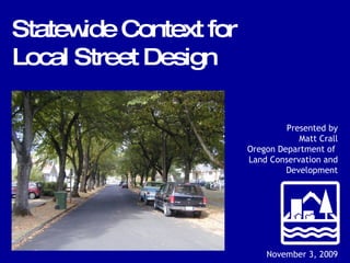
- 1. Presented by Matt Crall Oregon Department of Land Conservation and Development November 3, 2009 Statewide Context for Local Street Design
- 5. Transportation Planning Rule (TPR) - 1991 -
- 7. National research recommending narrow streets ITE ULI ASCE NAHB APA AASHTO TPR amendment adding 0045(7) - 1995 -
- 10. Celebration Kentlands National Examples TPR amendment adding 0045(7) - 1995 -
- 11. Oregon Examples Corvallis Yamhill TPR amendment adding 0045(7) - 1995 -
- 13. Requirement “ Local governments shall establish standards for local streets and accessways that minimize pavement width and total right-of-way consistent with the operational needs of the facility.” Oregon Administrative Rule 660-012-0045 (7) TPR amendment adding 0045(7) - 1995 -
- 22. Neighborhood Street Guidelines - 2000 – 28-foot wide - Parking on both sides
- 23. 28-foot wide - Parking on both sides Neighborhood Street Guidelines - 2000 –
- 24. 24-foot wide - Parking on one side Neighborhood Street Guidelines - 2000 –
- 25. 24-foot wide - Parking on one side Neighborhood Street Guidelines - 2000 –
- 26. 20-foot wide - No on-street parking Neighborhood Street Guidelines - 2000 –
- 27. 20-foot wide - No on-street parking Neighborhood Street Guidelines - 2000 –