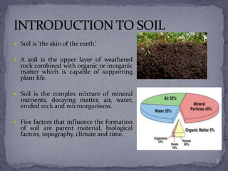
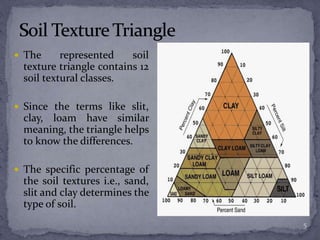
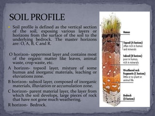
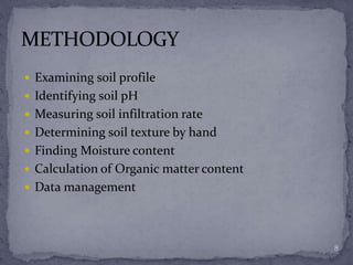
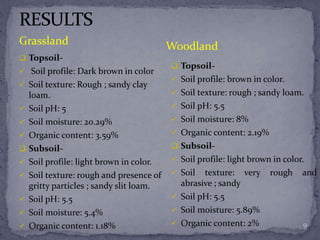
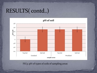
A presentation by Alisha Dahal and Rojina Timalsina
1
 Introduction to soil
 Soil types
 Importance of soil
 Soil profile
 Methodology
 Results
 Discussion
 Conclusion
2
 Soil is ‘the skin of the earth.’
 A soil is the upper layer of weathered
rock combined with organic or inorganic
matter which is capable of supporting
plant life.
 Soil is the complex mixture of mineral
nutrients, decaying matter, air, water,
eroded rock and microorganisms.
 Five factors that influence the formation
of soil are parent material, biological
factors, topography, climate and time.
3
There are three major divisions based on texture i.e., sand, slit and clay.
Sand-
 Size varies between 0.05-2.0 mm
 Rough in texture
 Does not stick together due to its large size.
 Filters water
 Forms soil with large pores.
Slit-
 Size varies between 0.002-0.05mm.
 Smooth
 Resists filtration
 Can hold water in well manner.
Clay-
 Very small, diameter less than 0.002mm.
 Gets easily stickled.
 Very less space between particles in order to hold water.
 Highly compact. 4
 The represented soil
texture triangle contains 12
soil textural classes.
 Since the terms like slit,
clay, loam have similar
meaning, the triangle helps
to know the differences.
 The specific percentage of
the soil textures i.e., sand,
slit and clay determines the
type of soil.
5
 Foundation of nutrients.
 Plays a role for the growth of all plants.
 Serves as a main component in nutrient cycle by the
process of decomposition.
 Modifies the atmosphere by emitting and absorbing
gases.
 Provides shelter to the animals that habitats in the soil
such as bacteria, fungi, mice, earthworm, etc.
 Purify almost all sources of water in terrestrial systems.
 Helps in reprocessing man made wastes.
 Acts as a foundation for construction works.
6
 Soil profile is defined as the vertical section
of the soil, exposing various layers or
horizons from the surface of the soil to the
underlying bedrock. The master horizons
are: O, A, B, C and R.
O horizon- uppermost layer and contains most
of the organic matter like leaves, animal
waste, crop waste, etc.
A horizon- topsoil layer, mixture of some
humus and inorganic materials, leaching or
eluviations zone.
B horizon- subsoil layer, composed of inorganic
materials, illuviation or accumulation zone.
C horizon- parent material layer, the layer from
which the soil develops, large pieces of rock
that have not gone much weathering.
R horizon- Bedrock.
7
 Examining soil profile
 Identifying soil pH
 Measuring soil infiltration rate
 Determining soil texture by hand
 Finding Moisture content
 Calculation of Organic matter content
 Data management
8
 Topsoil-
 Soil profile: Dark brown in color
 Soil texture: Rough ; sandy clay
loam.
 Soil pH: 5
 Soil moisture: 20.29%
 Organic content: 3.59%
 Subsoil-
 Soil profile: light brown in color.
 Soil texture: rough and presence of
gritty particles ; sandy slit loam.
 Soil pH: 5.5
 Soil moisture: 5.4%
 Organic content: 1.18%
 Topsoil-
 Soil profile: brown in color.
 Soil texture: rough ; sandy loam.
 Soil pH: 5.5
 Soil moisture: 8%
 Organic content: 2.19%
 Subsoil-
 Soil profile: light brown in color.
 Soil texture: very rough and
abrasive ; sandy
 Soil pH: 5.5
 Soil moisture: 5.89%
 Organic content: 2%
WoodlandGrassland
9
0.00
5.50
11.00
16.50
22.00
27.50
Grassland Woodland
Moisturecontent(%)
Sample area
Top Soil Sub Soil
FIG 1 : Moisture content across sample sites
10
0.00
1.00
2.00
3.00
4.00
Grassland Woodland
OrganicContent(%)
Sample area
Top Soil Sub Soil
FIG2: Organic matter content across sample sites
11
4.4
4.6
4.8
5
5.2
5.4
5.6
5.8
Top Soil Sub Soil Top Soil Sub Soil
Grassland Woodland
pHscale
sample areas
pH of soil
FIG3: pH of types of soils of sampling areas
12
 Moisture content was high in grassland as compared to
forest because evaporation rate is different in both the
sites. As seen by the observation, topsoil of grassland was
highly moisture which might be because of the crop land
area. Similarly, since the land was nearby the river, the
subsoil must have been dried up containing very less
moisture.
 Likely, organic matter was also high in grassland due high
use of compost and organic waste as a fertilizer whereas in
woodland it was relatively less.
 Findings have shown that grassland have more PH than
that of forest soils because grassland sites lies in city area
where soils are slightly acidic which might be due to more
disposal of organic wastes. 13
In a nutshell, pH of soils were similar in both the sample
areas whereas organic matter content has been
fluctuated by some physical factors. Likewise, the
moisture content has also varied in both the areas
having highest in topsoil of grassland which might
probably be the result of either some external factors
or may be due to its location. Thus, different
properties of soil were observed.
14
THANK YOU !!
15

Soil Profile

  • 1.
    A presentation byAlisha Dahal and Rojina Timalsina 1
  • 2.
     Introduction tosoil  Soil types  Importance of soil  Soil profile  Methodology  Results  Discussion  Conclusion 2
  • 3.
     Soil is‘the skin of the earth.’  A soil is the upper layer of weathered rock combined with organic or inorganic matter which is capable of supporting plant life.  Soil is the complex mixture of mineral nutrients, decaying matter, air, water, eroded rock and microorganisms.  Five factors that influence the formation of soil are parent material, biological factors, topography, climate and time. 3
  • 4.
    There are threemajor divisions based on texture i.e., sand, slit and clay. Sand-  Size varies between 0.05-2.0 mm  Rough in texture  Does not stick together due to its large size.  Filters water  Forms soil with large pores. Slit-  Size varies between 0.002-0.05mm.  Smooth  Resists filtration  Can hold water in well manner. Clay-  Very small, diameter less than 0.002mm.  Gets easily stickled.  Very less space between particles in order to hold water.  Highly compact. 4
  • 5.
     The representedsoil texture triangle contains 12 soil textural classes.  Since the terms like slit, clay, loam have similar meaning, the triangle helps to know the differences.  The specific percentage of the soil textures i.e., sand, slit and clay determines the type of soil. 5
  • 6.
     Foundation ofnutrients.  Plays a role for the growth of all plants.  Serves as a main component in nutrient cycle by the process of decomposition.  Modifies the atmosphere by emitting and absorbing gases.  Provides shelter to the animals that habitats in the soil such as bacteria, fungi, mice, earthworm, etc.  Purify almost all sources of water in terrestrial systems.  Helps in reprocessing man made wastes.  Acts as a foundation for construction works. 6
  • 7.
     Soil profileis defined as the vertical section of the soil, exposing various layers or horizons from the surface of the soil to the underlying bedrock. The master horizons are: O, A, B, C and R. O horizon- uppermost layer and contains most of the organic matter like leaves, animal waste, crop waste, etc. A horizon- topsoil layer, mixture of some humus and inorganic materials, leaching or eluviations zone. B horizon- subsoil layer, composed of inorganic materials, illuviation or accumulation zone. C horizon- parent material layer, the layer from which the soil develops, large pieces of rock that have not gone much weathering. R horizon- Bedrock. 7
  • 8.
     Examining soilprofile  Identifying soil pH  Measuring soil infiltration rate  Determining soil texture by hand  Finding Moisture content  Calculation of Organic matter content  Data management 8
  • 9.
     Topsoil-  Soilprofile: Dark brown in color  Soil texture: Rough ; sandy clay loam.  Soil pH: 5  Soil moisture: 20.29%  Organic content: 3.59%  Subsoil-  Soil profile: light brown in color.  Soil texture: rough and presence of gritty particles ; sandy slit loam.  Soil pH: 5.5  Soil moisture: 5.4%  Organic content: 1.18%  Topsoil-  Soil profile: brown in color.  Soil texture: rough ; sandy loam.  Soil pH: 5.5  Soil moisture: 8%  Organic content: 2.19%  Subsoil-  Soil profile: light brown in color.  Soil texture: very rough and abrasive ; sandy  Soil pH: 5.5  Soil moisture: 5.89%  Organic content: 2% WoodlandGrassland 9
  • 10.
    0.00 5.50 11.00 16.50 22.00 27.50 Grassland Woodland Moisturecontent(%) Sample area TopSoil Sub Soil FIG 1 : Moisture content across sample sites 10
  • 11.
    0.00 1.00 2.00 3.00 4.00 Grassland Woodland OrganicContent(%) Sample area TopSoil Sub Soil FIG2: Organic matter content across sample sites 11
  • 12.
    4.4 4.6 4.8 5 5.2 5.4 5.6 5.8 Top Soil SubSoil Top Soil Sub Soil Grassland Woodland pHscale sample areas pH of soil FIG3: pH of types of soils of sampling areas 12
  • 13.
     Moisture contentwas high in grassland as compared to forest because evaporation rate is different in both the sites. As seen by the observation, topsoil of grassland was highly moisture which might be because of the crop land area. Similarly, since the land was nearby the river, the subsoil must have been dried up containing very less moisture.  Likely, organic matter was also high in grassland due high use of compost and organic waste as a fertilizer whereas in woodland it was relatively less.  Findings have shown that grassland have more PH than that of forest soils because grassland sites lies in city area where soils are slightly acidic which might be due to more disposal of organic wastes. 13
  • 14.
    In a nutshell,pH of soils were similar in both the sample areas whereas organic matter content has been fluctuated by some physical factors. Likewise, the moisture content has also varied in both the areas having highest in topsoil of grassland which might probably be the result of either some external factors or may be due to its location. Thus, different properties of soil were observed. 14
  • 15.

Editor's Notes

  • #4 Formation- Available at: https://extension.illinois.edu/soil/soil_frm/soil_frm.htm Picture source: https://www.slideshare.net/Saadfarooqi/soil-profile-54182486 http://bayousoil.com/wp-content/uploads/2015/09/What-Is-Soil-Organic-Matter_Natural-Resources-Conservation.jpg
  • #5 Available at: https://www.slideshare.net/mdonohue/soil-ppt Picture source: https://www.nrcs.usda.gov/Internet/FSE_MEDIA/nrcs142p2_026219.jpg https://www.nrcs.usda.gov/Internet/FSE_MEDIA/nrcs142p2_025533.jpg https://www.lawnstarter.com/blog/wp-content/uploads/2016/08/grainy-soil.jpg
  • #6 Available at: http://www.newagegarden.net/wp-content/uploads/2015/04/soil.gif https://www.soils.org/files/about-soils/soils-overview.pdf
  • #7 Picture source: http://www.thefreshquotes.com/wp-content/uploads/2015/11/No-Food-Without-Soil.-800x450.jpg
  • #8 https://www.slideshare.net/gladysdelapena/soil-profile-53674513 https://www.slideshare.net/mdonohue/soil-ppt Picture source: https://i.infopls.com/images/ency048soilay001.jpg