SOCIAL SCIENCE 3º. UNIT 1. MAPS
•
0 likes•1,424 views

Maps. Types of Maps. Parts of a Map. Continents and Oceans.

Recommended
More Related Content
More from Irene Méndez Román
More from Irene Méndez Román (13)
Recently uploaded
Recently uploaded (20)
SOCIAL SCIENCE 3º. UNIT 1. MAPS
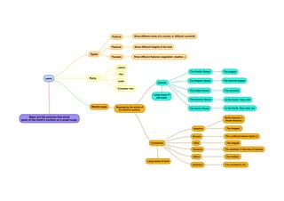
- 1. MAPS Maps are flat pictures that show parts of the Earth's surface on a small scale. Types Physical Show different heights of the land Political Show different areas of a country or different countries Thematic Show different features (vegetation, weather...) Parts Labels key scale Compass rose World maps Represents the whole of the Earth's surface: Continents Large areas of land America The longest. North America + South America Europe The continent where Spain is Asia The largest Oceania The smallest. It has lots of islands Africa The hottest. Antartica It is covered in ice. Oceans Large areas of salt water. The Pacific Ocean The largest The Atlantic Ocean The second largest The Indian Ocean The warmest The Arctic Ocean In the North. Very cold, too The Antartic Ocean In the South. Very cold