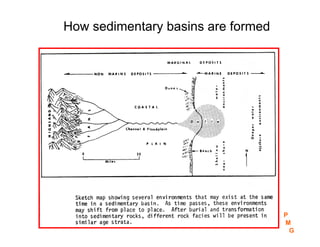
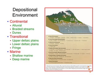
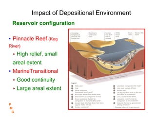
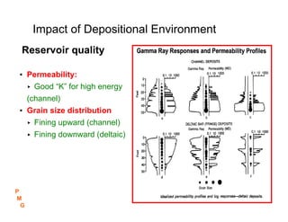
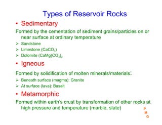
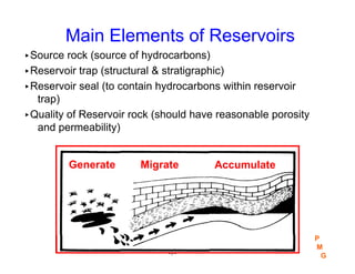
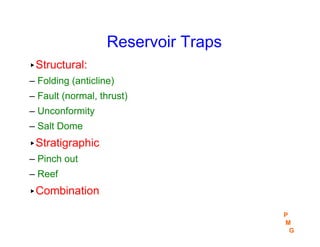
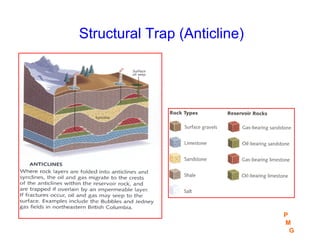
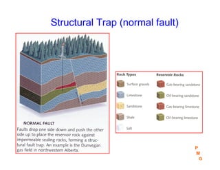
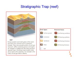
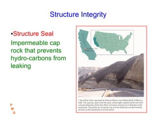
Petroleum Geology
P
M
G
Section #1
Reservoir Formation
▸Geologic cycle
▸Geologic time
▸Depositional Environment
▸Types of reservoir rocks
▸Main elements of petroleum reservoirs
▸Geologic subsurface maps
P
M
G
Geologic Cycle
▸The cooling and movements of earth inner molten
rocks caused warping and movements of the crust
resulting in the formation of mountains and valleys
▸Erosion/weathering (wind, water and temp.) is the
process of earth breakdown into rock grains.
▸Rock grains are transported by water and deposited
in the sedimentary basins (valleys or the sea) in
horizontal beds.
▸Sedimentary beds are uplifted by structural
movements and the cycle is repeated
P
M
G
How sedimentary basins are formed
P
M
G
Erosion Effects !!
P
M
G
Depositional
Environment
▪ Continental
▸ Alluvial
▸ Braided streams
▸ Dunes
▪ Transitional
▸ Upper deltaic plains
▸ Lower deltaic plains
▸ Fringe
▪ Marine
▸ Shallow marine
▸ Deep marine
P
M
G
Impact of Depositional Environment
▪ Pinnacle Reef (Keg
River)
▸ High relief, small
areal extent
▪ MarineTransitional
▸ Good continuity
▸ Large areal extent
Reservoir configuration
P
M
G
Impact of Depositional Environment
▪ Permeability:
▸ Good “K” for high energy
(channel)
▪ Grain size distribution
▸ Fining upward (channel)
▸ Fining downward (deltaic)
Reservoir quality
P
M
G
Aerial View of Deposition Environments
P
M
G
Geologic Time
• Oldest beds are deposited in the bottom
• Due to erosion and/or non-deposition, no single
sequence is a complete record of geologic time
(Table 1)
• Paleontology (study of fossils) is used to define
geologic periods
• Natural radioactivity of minerals (Uranium &
Thorium) determines absolute rock age.
P
M
G
Geologic Periods
History of plants &
organic life
P
M
G
Geologic
Time Table
Table 1
P
M
G
Types of Reservoir Rocks
• Sedimentary
Formed by the cementation of sediment grains/particles on or
near surface at ordinary temperature
¾ Sandstone
¾ Limestone (CaCO3)
¾ Dolomite (CaMg(CO3)2
• Igneous
Formed by solidification of molten minerals/materials:
¾ Beneath surface (magma): Granite
¾ At surface (lava): Basalt
• Metamorphic
Formed within earth’s crust by transformation of other rocks at
high pressure and temperature (marble, slate) P
M
G
Main Elements of Reservoirs
▸Source rock (source of hydrocarbons)
▸Reservoir trap (structural & stratigraphic)
▸Reservoir seal (to contain hydrocarbons within reservoir
trap)
▸Quality of Reservoir rock (should have reasonable porosity
and permeability)
-7-
Migrate
Generate Accumulate
P
M
G
Source Rocks
▸Rivers carried masses of sediments to the sea with plants &
animal life (organic materials)
▸Organic materials, deposited at the bottom of sea were
covered and compacted with sand & silt. Sealed from oxygen,
the organic material decomposed under pressure, temperature,
and bacteria into hydrocarbons.
▸Continuous sedimentation exerted high overburden pressure
which “squeezed” hydro-carbons out the source beds into
porous sedimentary structures.
Source rocks are classified according to the amount of &
type of organic matters, the degree of maturation and
thermal alteration
P
M
G
Reservoir Traps
▸Structural:
– Folding (anticline)
– Fault (normal, thrust)
– Unconformity
– Salt Dome
▸Stratigraphic
– Pinch out
– Reef
▸Combination
P
M
G
Structural Trap (Anticline)
P
M
G
Structural Trap (Anticline)
P
M
G
Structural Trap (normal fault)
P
M
G
Structural Trap (thrust fault)
P
M
G
Structural Trap (salt dome)
P
M
G
Stratigraphic Trap (pinch out)
P
M
G
Stratigraphic Trap (reef)
P
M
G
P
M
G
Structure Integrity
▪Structure Seal
Impermeable cap
rock that prevents
hydro-carbons from
leaking
P
M
G
Structure Integrity, cont.
▪ Structure Relief
Structural relief will
have different structural
closure, according to
the regional dip
P
M
G
Type of trapped fluids
-10-
P
M
G
Types of trapped fluids, cont.
P
M
G
Quality of Reservoir Rocks
▸Porosity
Connected porosity to store economic volume
of hydrocarbons
▸Permeability:
The ease at which fluids can move through the
porous rock
P
M
G
Geologic Subsurface Maps
▸Structure contour maps of structure or zone tops
▸Data is obtained from open hole logs or seismic interpretations
▸Net pay map using specific cut-off values to gross pay
thickness
▸Hydro-carbon pore volume map (HCPV)
▸Geologic Cross-sections:
– Structural: Open hole logs are illustrated, as such, “hanging on the
wells” is based on a selected datum depth in subsea
– Stratigraphic: Open hole logs are illustrated, as such, “hanging on the
wells” is based on a selected strata or zone
P
M
G

Section 1-GEOLOGY .pdf

  • 1.
  • 2.
    Reservoir Formation ▸Geologic cycle ▸Geologictime ▸Depositional Environment ▸Types of reservoir rocks ▸Main elements of petroleum reservoirs ▸Geologic subsurface maps P M G
  • 3.
    Geologic Cycle ▸The coolingand movements of earth inner molten rocks caused warping and movements of the crust resulting in the formation of mountains and valleys ▸Erosion/weathering (wind, water and temp.) is the process of earth breakdown into rock grains. ▸Rock grains are transported by water and deposited in the sedimentary basins (valleys or the sea) in horizontal beds. ▸Sedimentary beds are uplifted by structural movements and the cycle is repeated P M G
  • 4.
    How sedimentary basinsare formed P M G
  • 5.
  • 6.
    Depositional Environment ▪ Continental ▸ Alluvial ▸Braided streams ▸ Dunes ▪ Transitional ▸ Upper deltaic plains ▸ Lower deltaic plains ▸ Fringe ▪ Marine ▸ Shallow marine ▸ Deep marine P M G
  • 7.
    Impact of DepositionalEnvironment ▪ Pinnacle Reef (Keg River) ▸ High relief, small areal extent ▪ MarineTransitional ▸ Good continuity ▸ Large areal extent Reservoir configuration P M G
  • 8.
    Impact of DepositionalEnvironment ▪ Permeability: ▸ Good “K” for high energy (channel) ▪ Grain size distribution ▸ Fining upward (channel) ▸ Fining downward (deltaic) Reservoir quality P M G
  • 9.
    Aerial View ofDeposition Environments P M G
  • 10.
    Geologic Time • Oldestbeds are deposited in the bottom • Due to erosion and/or non-deposition, no single sequence is a complete record of geologic time (Table 1) • Paleontology (study of fossils) is used to define geologic periods • Natural radioactivity of minerals (Uranium & Thorium) determines absolute rock age. P M G
  • 11.
    Geologic Periods History ofplants & organic life P M G
  • 12.
  • 13.
    Types of ReservoirRocks • Sedimentary Formed by the cementation of sediment grains/particles on or near surface at ordinary temperature ¾ Sandstone ¾ Limestone (CaCO3) ¾ Dolomite (CaMg(CO3)2 • Igneous Formed by solidification of molten minerals/materials: ¾ Beneath surface (magma): Granite ¾ At surface (lava): Basalt • Metamorphic Formed within earth’s crust by transformation of other rocks at high pressure and temperature (marble, slate) P M G
  • 14.
    Main Elements ofReservoirs ▸Source rock (source of hydrocarbons) ▸Reservoir trap (structural & stratigraphic) ▸Reservoir seal (to contain hydrocarbons within reservoir trap) ▸Quality of Reservoir rock (should have reasonable porosity and permeability) -7- Migrate Generate Accumulate P M G
  • 15.
    Source Rocks ▸Rivers carriedmasses of sediments to the sea with plants & animal life (organic materials) ▸Organic materials, deposited at the bottom of sea were covered and compacted with sand & silt. Sealed from oxygen, the organic material decomposed under pressure, temperature, and bacteria into hydrocarbons. ▸Continuous sedimentation exerted high overburden pressure which “squeezed” hydro-carbons out the source beds into porous sedimentary structures. Source rocks are classified according to the amount of & type of organic matters, the degree of maturation and thermal alteration P M G
  • 16.
    Reservoir Traps ▸Structural: – Folding(anticline) – Fault (normal, thrust) – Unconformity – Salt Dome ▸Stratigraphic – Pinch out – Reef ▸Combination P M G
  • 17.
  • 18.
  • 19.
  • 20.
  • 21.
  • 22.
  • 23.
  • 24.
  • 25.
    Structure Integrity ▪Structure Seal Impermeablecap rock that prevents hydro-carbons from leaking P M G
  • 26.
    Structure Integrity, cont. ▪Structure Relief Structural relief will have different structural closure, according to the regional dip P M G
  • 27.
    Type of trappedfluids -10- P M G
  • 28.
    Types of trappedfluids, cont. P M G
  • 29.
    Quality of ReservoirRocks ▸Porosity Connected porosity to store economic volume of hydrocarbons ▸Permeability: The ease at which fluids can move through the porous rock P M G
  • 30.
    Geologic Subsurface Maps ▸Structurecontour maps of structure or zone tops ▸Data is obtained from open hole logs or seismic interpretations ▸Net pay map using specific cut-off values to gross pay thickness ▸Hydro-carbon pore volume map (HCPV) ▸Geologic Cross-sections: – Structural: Open hole logs are illustrated, as such, “hanging on the wells” is based on a selected datum depth in subsea – Stratigraphic: Open hole logs are illustrated, as such, “hanging on the wells” is based on a selected strata or zone P M G