SlideShare a Scribd company logo
MOVINGFORWARDTHINKING 
Taking Pedestrian and Bicycle Counting 
Programs to the Next Level 
Lessons from NCHRP 07-19 
Robert Schneider, UW Milwaukee 
RJ Eldridge, Toole Design Group 
Conor Semler, Kittelson & Associates 
ProWalk/ProBike/ProPlace 
Pittsburgh, PA 
September 2014 Source: Kittelson & Associates, Inc.
Presentation Overview 
 Introduction 
 State of the Practice 
 Count Applications 
 Testing Approach and 
Findings 
 Guidebook Overview 
 Questions and 
Discussion 
2 
Source: Toole Design Group
NCHRP 7-19 Research Team 
 Kittelson & Associates, Inc. 
– Principal Investigator: Paul Ryus 
 University of Wisconsin-Milwaukee 
 UC Berkeley, SafeTREC 
 Toole Design Group 
 McGill University 
 Quality Counts, LLC 
3
Project Purpose 
 Address lack of 
pedestrian and 
bicycle volume data 
 Assess data 
collection 
technologies and 
methods 
 Develop guidance 
for practitioners 
4 
Source: Bob Schneider, UW-Milwaukee
Related Work 
 National Bicycle and Pedestrian 
Documentation Project 
 FHWA Traffic Monitoring Guide 
(TMG) 
– 2013 edition includes chapter on 
non-motorized traffic 
– NCHRP research complements 
FHWA guide 
5
State of the Practice 
 Early Findings 
 Multimodal Count Applications 
6 
Source: Bob Schneider, UW-Milwaukee
MOVINGFORWARDTHINKING 
NCHRP 7-19 Survey (N = 269) 
10 
20 
36 
3 
11 
69 
2 
35 
39 
20 
0 10 20 30 40 50 60 70 80 
Other 
University 
STATE DOT 
U.S. federal agency 
U.S. County 
U.S. city 
Transit agency 
Non-profit/advocacy 
MPO 
Consulting firm 
SURVEY RESPONSES
NCHRP 7-19 Survey Findings 
• Pedestrian and bicycle counts are becoming routine 
for cities, MPOs, and State DOTs. 
• Manual counts are the most prevalent data collection 
method 
• Most programs lack formal or dedicated funding 
source and rely heavily on volunteers 
• Organizations serving larger communities are more 
likely to conduct pedestrian and/or bicycle counts. 
• Some integration with motor vehicle count databases.
Current Methods of Bicycle Counting
NCHRP 7-19 Survey Findings 
 There is no standard approach for count 
programs 
 Practitioners are looking for more guidance 
– Choosing devices 
– Selecting locations 
– Count intervals and duration 
– Temporal/seasonal adjustments
Pedestrian & Bicycle Count Applications 
 Measuring facility usage 
 Evaluating before-and-after data 
 Monitoring travel patterns 
 Safety analysis 
 Project prioritization 
 Multimodal modeling 
11
Measuring Facility Usage 
 Transportation system monitoring program 
 Typically requires collecting counts at set 
locations and regular intervals 
 Critical for tracking progress and measuring 
success 
12 
Change in Walking and 
Bicycling Activity at 
Washington State Count Sites, 
2009–2012 
Source: Washington State DOT (2012)
Evaluating Before-and-After Volumes 
 Measure volumes before and after facility is 
opened 
 Forecast usage of planned facilities 
13 
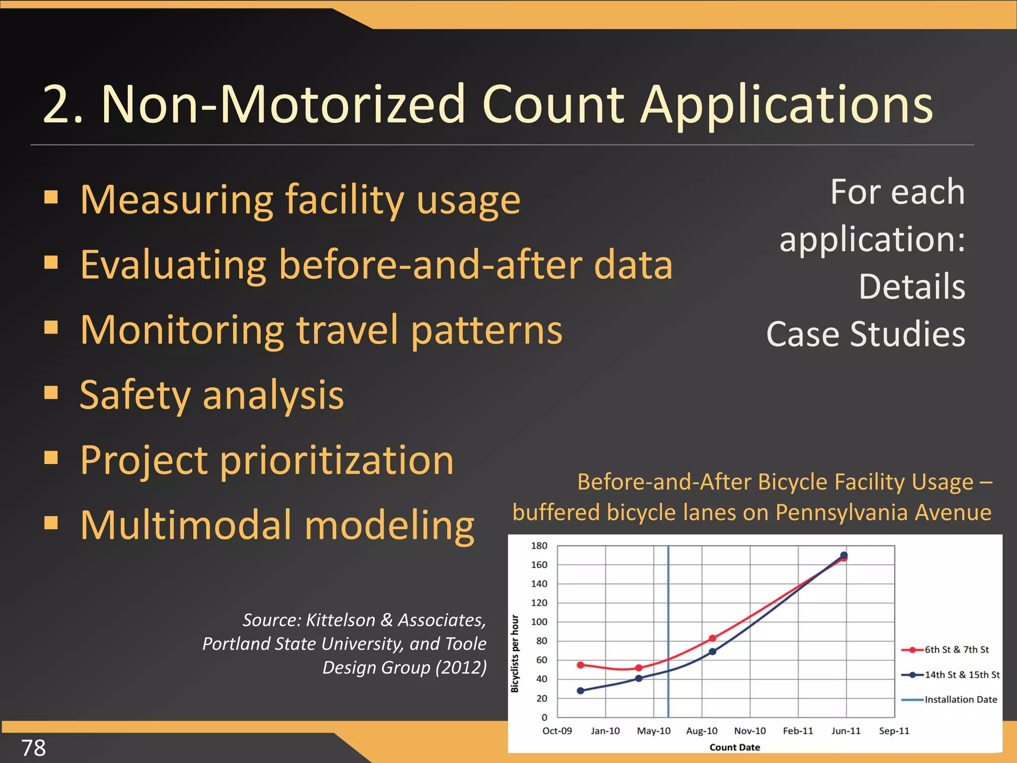
Before-and-After Bicycle Facility Usage – buffered bicycle lanes on Pennsylvania Ave 
Source: Kittelson & 
Associates, Portland State 
University, and Toole Design 
Group (2012)
Monitoring Travel Patterns 
 Developing extrapolation factors 
– Extrapolate short-duration counts over longer time 
periods 
– Control for effect of land use, weather, 
demographics, etc. 
 Evaluating user behavior patterns 
– Identify factors that influence walking/biking 
– Controllable (land use) and uncontrollable (weather) 
factors 
14
Safety Analysis 
 Quantifying exposure 
– Variety of methods proposed to quantify exposure 
– One method compares pedestrian-vehicle collissions 
to average annual pedestrian volumes 
 Identifying before-and-after safety effects 
15
Mainline 
Roadway 
Intersecting 
Roadway 
Reported 
Pedestrian 
Crashes (1996- 
2005) 
Mission 
Boulevard 
Torrano 
Avenue 5 
Davis Street Pierce Avenue 4 
Foothill 
Boulevard D Street 1 
Mission 
Boulevard 
Jefferson 
Street 5 
University 
Avenue Bonar Street 7 
International 
Boulevard 107th Avenue 2 
San Pablo 
Avenue Harrison Street 2 
East 14th 
Street 
Hasperian 
Boulevard 1 
International 
Boulevard 46th Avenue 3 
Solano Avenue 
Masonic 
Avenue 2 
Broadway 12th Street 5 
Alameda County Pedestrian Crash Analysis
Mainline Roadway 
Intersecting Roadway 
Estimated Total Weekly Pedestrian Crossings 
Annual Pedestrian Volume Estimate 
Ten-Year Pedestrian Volume Estimate 
Reported Pedestrian Crashes (1996- 2005) 
Pedestrian Risk (Crashes per 10,000,000 crossings) 
Mission Boulevard 
Torrano Avenue 
1,169 
60,796 
607,964 
5 
82.24 
Davis Street 
Pierce Avenue 
1,570 
81,619 
816,187 
4 
49.01 
Foothill Boulevard 
D Street 
632 
32,862 
328,624 
1 
30.43 
Mission Boulevard 
Jefferson Street 
5,236 
272,246 
2,722,464 
5 
18.37 
University Avenue 
Bonar Street 
11,175 
581,113 
5,811,127 
7 
12.05 
International Boulevard 
107th Avenue 
3,985 
207,243 
2,072,429 
2 
9.65 
San Pablo Avenue 
Harrison Street 
4,930 
256,357 
2,563,572 
2 
7.80 
East 14th Street 
Hasperian Boulevard 
3,777 
196,410 
1,964,102 
1 
5.09 
International Boulevard 
46th Avenue 
12,303 
639,752 
6,397,522 
3 
4.69 
Solano Avenue 
Masonic Avenue 
22,203 
1,154,559 
11,545,589 
2 
1.73 
Broadway 
12th Street 
112,896 
5,870,590 
58,705,898 
5 
0.85 
Alameda County Pedestrian Crash Analysis
Mainline Roadway 
Intersecting Roadway 
Estimated Total Weekly Pedestrian Crossings 
Annual Pedestrian Volume Estimate 
Ten-Year Pedestrian Volume Estimate 
Reported Pedestrian Crashes (1996- 2005) 
Pedestrian Risk (Crashes per 10,000,000 crossings) 
Mission Boulevard 
Torrano Avenue 
1,169 
60,796 
607,964 
5 
82.24 
Broadway 
12th Street 
112,896 
5,870,590 
58,705,898 
5 
0.85 
Alameda County Pedestrian Crash Analysis
Project Prioritization 
 Identify high-priority locations 
for improvements 
 Identify factors that influence 
walking/biking and prioritize 
accordingly 
 Measure improper user 
behaviors (i.e., wrong-way bike 
riding) to identify areas 
needing improvement 
19
Multimodal Model Development 
 Multimodal travel 
demand modeling is an 
emerging field 
 Potential to estimate 
demand over a large 
area and forecast 
influence of 
infrastructure changes 
20 
Source: City of Berkeley, CA 
Pedestrian Master Plan
We need these data fields! 
Institutionalize Pedestrian & Bicycle Data 
 A multimodal transportation system requires 
collecting data for all modes of transportation 
 Establish baseline for pedestrian & bicycle safety, 
infrastructure, volumes, etc. 
X-Street 
Traffic 
Volume 
Mainline 
Traffic 
Volume 
X-Street 
Pedestrian 
Volume 
Mainline 
Pedestrian 
Volume
Challenges to Bicycle and Pedestrian 
Counting 
 Where to count? 
 When (how long/how 
frequently) to count? 
 What to count? 
 How to count? 
 Site/Mode challenges 
 Who should be counting? 
Source: Toole Design Group
Arlington County’s automated 
bicycle and pedestrian count 
program 
• First counter Custis Trail: 
Fall 2009 
• Now 30 automatic counter 
stations 
• Automatic uploads to 
central server 
• Web based “dashboard” 
• Plans for real-time “totem” 
counter display 
Case Study: Arlington County, VA 
Statistics and graphics courtesy of David Patton 
Bicycle & Pedestrian Planner, Arlington County Division 
of Transportation
NCHRP 7-19 Research Approach 
 Focus on testing and evaluating commercially 
available automated technologies 
 Assess type of technology as opposed to a 
specific product 
 Cover a range of facility types, mix of traffic, 
and geographic locations 
 Evaluate accuracy through the use of manual 
count video data reduction 
24
Types of Counts
Motor Vehicle Data Collection 
 Inductive Loops 
 Pneumatic Tubes 
 Manual Count Boards 
 Video cameras 
 ITS integration 
 In-vehicle sensors (toll 
tags) 
Photo Credit: Federal Highway Administration
Auto versus Multimodal Counts 
 Key differences: 
– Differences in demand 
variability 
– Ease of detection 
– Experience with 
counting technology 
27 
0 
2,000 
4,000 
6,000 
8,000 
10,000 
12,000 
0 6 12 18 24 
Hourly Volume (veh/h) 
Hour Starting 
Monday Tuesday Wednesday Thursday Friday Annual Weekday Average
Motor Vehicle Data Collection 
Constrained; somewhat 
predictable 
Source: Toole Design Group
Bicycle Data Collection 
Constrained environments 
easy to monitor 
Complex environments 
harder to define 
Detection 
Source: Toole Design Group
Pedestrian Data Collection 
Constrained environments 
easy to monitor 
Detection 
People tend to make 
their own path 
Source: Toole Design Group
Motor vehicle data 
collection 
• Widely collected 
• Easy to track vehicle 
movements 
• Predictable patterns and 
routes 
• Years of trend data to 
analyze 
Bicycle and pedestrian 
data collection 
• Sparsely collected 
• Difficult to track and 
tabulate movements 
• Unpredictable paths of 
travel 
• Weather and seasonal 
impacts 
• Lack of historical data 
Challenge: Site/Mode characteristics
Counting System 
 Sensor technology one piece of 
counting system 
32
MOVINGFORWARDTHINKING 
NCHRP 07-19 Evaluation 
Automated devices that count all users 
(pedestrians and bicyclists)
Types of Counts
Passive Infrared (IR) 
 Detect pedestrians and 
cyclists by infrared 
radiation (heat) patterns 
them emit 
 Passive infrared sensor 
placed on one side of 
facility 
 Widely used and tested 
35 
Source: Toole Design Group
Active Infrared (IR) 
 Transmitter and 
receiver with IR beam 
 Counts caused by 
“breaking the beam” 
36 
Source: Steve Hankey, University of Minnesota
Radio Beam 
 Radio signal between 
transmitter and receiver 
 Detections occur when 
beam is broken 
 Not previously tested in 
literature 
 Some distinguish bikes 
from peds 
37 
Source: Karla Kingsley, Kittelson & Associates, Inc.
MOVINGFORWARDTHINKING 
NCHRP 07-19 Evaluation 
Automated devices that count 
bicyclists only
Pneumatic Tubes 
 Tube(s) stretched across 
roadway 
 When a bicycle rides over 
tube, pulse of air passes 
through tube to detector 
39 
Source: Karla Kingsley, Kittelson & Associates, Inc.
Inductive Loops 
 Generate a magnetic field 
that detect metal parts of 
bicycle passing over loop 
 In-pavement or 
temporary surface loops 
40 
Source: Toole Design Group
Piezoelectric Sensor 
 Emit an electric signal 
when physically deformed 
 Typically embedded in 
pavement across travel 
way 
41 
Source: Toole Design Group
MOVINGFORWARDTHINKING 
NCHRP 07-19 Evaluation 
Other counting methods
Combination 
 Use one technology to detect all others plus 
another technology to detect bicyclists only 
 Provide bicycle and pedestrian counts 
separately 
43 
Photo Sources: Bob Schneider, UW-Milwaukee
Manual Counts 
 Most common type of counting, to date 
 Capture many different locations 
 Record pedestrians & bicyclists separately 
 Can count road crossings 
 Capture user characteristics 
(gender, helmet use, 
behavior, etc.) 
Photo by Robert Schneider, UW-Milwaukee
Washington State DOT Pedestrian & Bicycle Counts 
Source: Cascade Bicycle Club. Washington State Bicycle and Pedestrian Documentation Project, Prepared for the Washington State Department 
of Transportation, February 2013.
Existing Market Technology 
• Passive infrared 
• Active infrared 
• Radio beam 
• Pneumatic tubes 
• Inductive loops 
• Piezoelectric sensors 
• Combination devices 
• Manual Counts 
• Automated video 
• Emerging technologies 
Understanding Count Technologies 
Classify Bicycle Only Everything 
Sources: Toole Design Group
Untested/Emerging technologies 
 Thermal 
 Radar 
 Laser scanners 
 Pressure and acoustic sensors 
 Automated video 
47
Related Work 
 Topics related to quantifying pedestrian & bicycle 
activity, but not covered: 
– Bluetooth and WiFi detection 
– GPS data collection 
– Cell/smartphone data collection 
– Radio frequency ID (RFID) tags 
– Bike sharing data 
– Pedestrian signal actuation buttons 
– Surveys 
– Presence detection 
– Trip generation 
48
Quick Break for Questions 
49 
Detection
Study Technologies and Site Locations 
 Technologies 
– Passive infrared 
– Active infrared 
– Pneumatic tubes 
– Inductive loops 
– Piezoelectric 
– Radio beam 
– Combination of 
technologies 
50 
 Site Locations 
– Portland, OR 
– San Francisco, CA 
– Davis, CA 
– Berkeley, CA 
– Minneapolis, MN 
– Washington, D.C. 
– Arlington, VA 
– Montreal, Canada
Washington, D.C. and Arlington, VA 
 Key Bridge separated path 
– Passive Infrared 
– Pneumatic Tubes 
– Passive Infrared with inductive loops 
51 
Source: Toole Design 
Group
Minneapolis, MN 
 Midtown Greenway 
multiuse path 
– Active Infrared 
– Passive Infrared 
– Radio Beam 
– Inductive Loops 
– Pneumatic Tubes 
52 
Source: Toole Design Group
 Eastbank Esplanade 
multiuse path 
– Passive Infrared 
– Pneumatic Tubes 
– Radio Beam 
Portland, OR 
53 
Source: Kittelson & Associates, Inc.
San Francisco, CA 
 Fell Street Bicycle Lane 
– Passive Infrared 
– Pneumatic Tubes 
– Inductive Loops 
54 
Source: Frank Proulx, UC Berkeley SafeTREC
Evaluation Method 
 Video-based manual counts 
 Interrater reliability tested 
55 
Source: Frank Proulx, UC Berkeley SafeTREC 
Source: Toole Design Group
Measures to Evaluate the Quality of Count 
Data from Technologies 
 Accuracy: The magnitude of the difference 
between the count produced by the technology, 
and actual (“ground-truth”) count. 
(Typically depends on user volumes, movement patterns, traffic mix, and environmental 
characteristics) 
 Consistency (Precision): The remaining variability in 
the count data after being corrected for expected 
under- or over-counting, given specific conditions. 
(Typically depends on the counting technology itself, how a specific vendor uses the 
technology in a particular product, and quality of installation) 
56
Graphical Analysis 
57 
Undercounting 
Overcounting 
Source: Frank Proulx, UC Berkeley SafeTREC
Active Infrared Counter Validation Data 
(Somewhat accurate, very precise)
(Somewhat accurate, but not precise) 
Passive Infrared Counter Validation Data
Evaluation Criteria 
 Accuracy 
 Precision 
 Ease of installation, maintenance 
requirements, cost, flexibility of data, etc. 
60
Summary of Data Collected 
Condition 
Passive 
Infrared 
Active 
Infrared 
Pneumatic 
Tubes 
Inductive 
Loops 
Inductive 
Loops 
(Facility) 
Piezo-electric 
Radio 
Beam 
Total hours of data 298 30 160 108 165 58 95 
Temperature (°F) 
(mean/SD) 
70 / 15 64 / 26 71 / 9 73 / 12 71 / 17 72 / 10 74 / 10 
Hourly user volume 
(mean/SD) 
240 / 190 328 / 249 218 / 203 128 / 88 200 / 176 128 / 52 129 / 130 
Nighttime hours 30 3 10 13 19 15.75 3.5 
Rain hours 17 0 4 7 7 0 6 
Cold hours (<30 °F) 12 5 0 0 7 0 0 
Hot hours (>90 °F) 11 0 0 5 5 3 4 
Thunder hours 8 0 0 2 2 0 0 
61
Passive Infrared 
 Easy installation 
 Mounts to existing pole/surface or in purpose-built 
pole 
 Potential false detections from background 
 Possible undercounting due to occlusion 
62
Passive Infrared 
 Average undercount rate 
8.75% 
 Differences between 
products tested 
 Correction function could 
account for facility width 
 Accuracy not affected by 
high temperatures 
63
Active Infrared 
 Moderately easy 
installation – requires 
aligning transmitter and 
receiver 
 Single device tested – 
accurate and highly 
precise 
64
Pneumatic Tubes 
 Tested BSCs – bicycle specific counters 
 Primarily tested tubes on multi-use paths and 
bicycle lanes 
 Issues with site on 15th Avenue in Minneapolis 
– Tube nails came out of ground 
– Severe undercounting and overcounting 
– Removed sensors from data set 
65
Pneumatic Tubes 
 Fairly high accuracy at 
very high volumes 
 Accuracy rates not 
observed to decline with 
aging tubes 
 Future research in mixed 
traffic settings 
66
Radio Beam 
 Required mounting devices 10’ apart 
 Tested two products: one that distinguished 
bicyclists and pedestrians (product A), one that 
did not (product B) 
67
Radio Beam 
 Product B higher 
accuracy 
 Product A – low 
precision and 
lower accuracy 
 Occlusion errors 
 Temperature, 
lighting, rain 
issues 
68
Inductive Loops 
 Permanent (in ground) or temporary (on 
surface) 
 Bypass errors 
– Cyclists passing 
outside bike lane 
– Loops leaving gaps 
in detection zone 
69
Inductive Loops 
 Accurate and precise 
 Errors with age of 
loops not detected 
 Higher volumes 
slightly affect 
accuracy 
 No substantial 
difference between 
permanent and 
temporary loops 
70
Inductive Loops 
 Need to mitigate bypass errors 
71
Piezoelectric Strips 
 Tested one existing 
device, due to 
difficulties procuring 
equipment 
 Data suggests device is 
not functioning very 
precisely or accurately 
 Caution – data from 
single device not 
installed by research 
team 
72
Combination Counter 
 Passive infrared + 
inductive loops 
 Each device also 
assessed separately 
 Inferred pedestrian 
volumes (Total – bikes) 
 Occlusion errors and 
undercounting 
 High rate of precision 
73
Accuracy Calculations 
74 
 Average percentage deviation (APD): overall 
divergence from perfect accuracy 
(undercounting rate) 
 Average of the absolute percentage deviation 
(AAPD): accounts for undercount/overcount 
cancelation (total deviation)
Research Conclusions 
Device Undercounting Rate Total Deviation 
Passive Infrared (2 products) 8.75% 20.11% 
Active Infrared 9.11% 11.61% 
Pneumatic Tubes 17.89% 18.50% 
Radio Beam 18.18% 48.15% 
Inductive Loops 0.55% 8.87% 
Piezoelectric Strips 11.36% 26.60% 
75 
 Automated counter accuracy:
Research Conclusions 
 Factors influencing accuracy 
– Proper calibration and installation 
– Occlusion 
– Vendor differences 
 Factors not found to influence accuracy 
– Age of inductive loops or pneumatic tubes 
– Temperature 
– Snow/rain (limited data) 
76
Guidebook Organization 
Quick Start Guide 
1. Introduction 
2. Non-Motorized Count Data Applications 
3. Data Collection Planning and Implementation 
4. Adjusting Count Data 
5. Sensor Technology Toolbox 
Case Studies 
Manual Pedestrian and Bicyclist Counts: Example Data Collector 
Instructions 
Count Protocol Used for NCHRP Project 07-19 
Appendix D. Day-of-Year Factoring Approach 
77 
Appendices
2. Non-Motorized Count Applications 
 Measuring facility usage 
 Evaluating before-and-after data 
 Monitoring travel patterns 
 Safety analysis 
 Project prioritization 
 Multimodal modeling 
Source: Kittelson & Associates, 
Portland State University, and Toole 
Design Group (2012) 
Before-and-After Bicycle Facility Usage – 
buffered bicycle lanes on Pennsylvania Avenue 
For each 
application: 
Details 
Case Studies 
78
3. Data Collection Planning & Implementation 
 Covers: 
1. Planning the count 
program 
2. Implementing the 
count program 
 Provides examples, 
detailed guidance, 
checklists 
Source: Toole Design Group. 
79
Common Strategy: Manual + Automated 
Geographic Coverage 
A Few 
Locations 
Many 
Locations 
Count Duration 
Continuous Automated 
Short-Term Manual
Comparison of Counting Technologies 
Characteristic 
Passive 
Infrared 
Active 
Infrared 
Pneumatic 
Tubes 
Inductive 
Loops 
Piezoelectric 
Sensor 
Passive IR + 
Inductive 
Loops 
Radio Beam 
(One 
Frequency) 
Radio Beam 
(High/Low 
Frequency) 
Automated 
Video1 
Manual 
Counts2 
Type of users counted 
All facility users Yes Yes Yes Yes Yes Yes Yes 
Pedestrians only Yes Yes Yes Yes 
Bicycles only Yes Yes Yes Yes Yes Yes Yes 
Pedestrians vs. bicycles Yes Yes Yes Yes 
Bicycles vs. automobiles Yes Yes Yes Yes 
Characteristics collected 
Different user types Yes Yes Yes Yes 
Direction of travel3 Yes Yes Yes Yes Yes Yes Yes Yes Yes 
User characteristics4 Yes Yes 
Types of sites counted 
Multiple-use trail segments Yes Yes Yes Yes Yes Yes Yes Yes Yes Yes 
Sidewalk segments Yes Yes Yes Yes Yes Yes Yes 
Bicycle lane segments Yes Yes Yes Yes Yes 
Cycle track segments Yes Yes Yes Yes Yes Yes 
Shared roadway segments Yes Yes Yes Yes 
Roadway crossings (detect 
from median)5 Yes Yes Yes Yes Yes Yes Yes Yes 
Roadway crossings (detect 
from end of crosswalk) Yes Yes 
Intersections (identify 
turning movements) Yes 
Notes: (1) Existing “automated video” systems may not use a completely automated counting process; they may also incorporate manual data checks of automated video processing. 
(2) Includes manual counts from video images. 
(3) Technologies noted as “Yes” have at least one vendor that uses the technology to capture directionality. 
(4) User characteristics include estimated age, gender, helmet use, use of wheelchair or other assistive device, pedestrian and bicyclist behaviors, and other characteristics. 
(5) Roadway crossings at medians potentially have issues with overcounting due to people waiting in the median. Median locations were not tested during this project.
Characteristic 
Passive 
Infrared 
Active 
Infrared 
Pneumatic 
Tubes 
Inductive 
Loops 
Piezoelectric 
Sensor 
Passive IR + 
Inductive 
Loops 
Radio Beam 
(One 
Frequency) 
Radio Beam 
(High/Low 
Frequency) 
Automated 
Video1 
Manual 
Counts2 
Type of users counted 
All facility users Yes Yes Yes Yes Yes Yes Yes 
Pedestrians only Yes Yes Yes Yes 
Bicycles only Yes Yes Yes Yes Yes Yes Yes 
Pedestrians vs. bicycles Yes Yes Yes Yes 
Bicycles vs. automobiles Yes Yes Yes Yes 
Characteristics collected 
Different user types Yes Yes Yes Yes 
Direction of travel3 Yes Yes Yes Yes Yes Yes Yes Yes Yes 
User characteristics4 Yes Yes 
Types of sites counted 
Multiple-use trail segments Yes Yes Yes Yes Yes Yes Yes Yes Yes Yes 
Sidewalk segments Yes Yes Yes Yes Yes Yes Yes 
Bicycle lane segments Yes Yes Yes Yes Yes 
Cycle track segments Yes Yes Yes Yes Yes Yes 
Shared roadway segments Yes Yes Yes Yes 
Roadway crossings (detect 
from median)5 Yes Yes Yes Yes Yes Yes Yes Yes 
Roadway crossings (detect 
from end of crosswalk) Yes Yes 
Intersections (identify 
turning movements) Yes 
Notes: (1) Existing “automated video” systems may not use a completely automated counting process; they may also incorporate manual data checks of automated video processing. 
(2) Includes manual counts from video images. 
(3) Technologies noted as “Yes” have at least one vendor that uses the technology to capture directionality. 
(4) User characteristics include estimated age, gender, helmet use, use of wheelchair or other assistive device, pedestrian and bicyclist behaviors, and other characteristics. 
(5) Roadway crossings at medians potentially have issues with overcounting due to people waiting in the median. Median locations were not tested during this project. 
Comparison of Counting Technologies
INSTALLATION CHECKLIST: ADVANCE PREPARATION 
Site visit to identify the specific installation location. Specifically, note poles that will be 
used, where pavement will be cut, or where utility boxes will be installed to house 
electronics. Verify that no potential obstructions (e.g., vegetation) or sources of 
interference (e.g., doorway, bus stop, bicycle rack) are present. 
Obtain and document necessary permissions. Permits or permissions may include right-of- 
way encroachment permits, pavement cutting permits or bonds, landscaping 
permits, or interagency agreements. Obtaining these permissions may take up to 
several months, particularly if other agencies are involved. 
Create a site plan. Develop a detailed diagram of the planned installation on an aerial 
photo or ground-level image documenting the intended equipment installation 
locations and anticipated detection zone (after installation this will be useful for 
validating equipment either visually or with video monitoring). This diagram may be 
useful for obtaining installation permissions and working with contractors. Figure 3-6 
provides an example site plan. 
Hire a contractor if necessary (or schedule appropriate resources from within the 
organization). 
Arrange an on-site coordination meeting involving all necessary parties (e.g., staff 
representing the organization installing the counter, permitting staff, contractors). If 
possible, a vendor representative should be on hand or available by phone. It may 
take several weeks to find a suitable time when everyone is available. 
Check for potential problems. Problems with the site may include interference from 
utility wires, upcoming constructions projects, hills, sharp curves, nearby illicit 
activity, and nearby insect and animal activity. Some of these conditions can be 
identified from imagery, but they should also be evaluated in the field.
INSTALLATION CHECKLIST: ADVANCE PREPARATION 
Site visit to identify the specific installation location. Specifically, note poles that will be 
used, where pavement will be cut, or where utility boxes will be installed to house 
electronics. Verify that no potential obstructions (e.g., vegetation) or sources of 
interference (e.g., doorway, bus stop, bicycle rack) are present. 
Obtain and document necessary permissions. Permits or permissions may include right-of- 
way encroachment permits, pavement cutting permits or bonds, landscaping 
permits, or interagency agreements. Obtaining these permissions may take up to 
several months, particularly if other agencies are involved. 
Create a site plan. Develop a detailed diagram of the planned installation on an aerial 
photo or ground-level image documenting the intended equipment installation 
locations and anticipated detection zone (after installation this will be useful for 
validating equipment either visually or with video monitoring). This diagram may be 
useful for obtaining installation permissions and working with contractors. Figure 3-6 
provides an example site plan. 
Hire a contractor if necessary (or schedule appropriate resources from within the 
organization). 
Arrange an on-site coordination meeting involving all necessary parties (e.g., staff 
representing the organization installing the counter, permitting staff, contractors). If 
possible, a vendor representative should be on hand or available by phone. It may 
take several weeks to find a suitable time when everyone is available. 
Check for potential problems. Problems with the site may include interference from 
utility wires, upcoming constructions projects, hills, sharp curves, nearby illicit 
activity, and nearby insect and animal activity. Some of these conditions can be 
identified from imagery, but they should also be evaluated in the field.
EQUIPMENT MONITORING CHECKLIST 
Sensor height. Is the sensor still mounted at the correct height? 
Sensor direction. Is the sensor still pointed in the correct direction? 
Clock. Is the device’s clock set correctly? 
Cleaning. Remove dirt, mud, water, or other material that may affect the sensor or other 
vital components. 
Battery. Is the remaining battery life sufficient to last until the next scheduled visit? 
Obstructions. For example, is vegetation growing too close to the device? 
Unanticipated site problems. For example, is the pole being used for bicycle parking, or 
are people congregating in the area (as opposed to walking past the counter)? 
Pedestrian or bicycle detection. Are pedestrians or bicyclists passing through the 
counter’s detection zone being counted? If not, can the counter’s sensitivity be 
adjusted in the field, or does it need to be removed for repairs? 
Download data. Use the same export option consistently to ease the data management 
burden back in the office. 
Securement. Are the installation elements and locking devices still secure and durable? 
Poorly secured or loose fitted devices are more vulnerable to theft and vandalism.
EQUIPMENT MONITORING CHECKLIST 
Sensor height. Is the sensor still mounted at the correct height? 
Sensor direction. Is the sensor still pointed in the correct direction? 
Clock. Is the device’s clock set correctly? 
Cleaning. Remove dirt, mud, water, or other material that may affect the sensor or other 
vital components. 
Battery. Is the remaining battery life sufficient to last until the next scheduled visit? 
Obstructions. For example, is vegetation growing too close to the device? 
Unanticipated site problems. For example, is the pole being used for bicycle parking, or 
are people congregating in the area (as opposed to walking past the counter)? 
Pedestrian or bicycle detection. Are pedestrians or bicyclists passing through the 
counter’s detection zone being counted? If not, can the counter’s sensitivity be 
adjusted in the field, or does it need to be removed for repairs? 
Download data. Use the same export option consistently to ease the data management 
burden back in the office. 
Securement. Are the installation elements and locking devices still secure and durable? 
Poorly secured or loose fitted devices are more vulnerable to theft and vandalism.
4. Adjusting Count Data 
 Sources of counter inaccuracy 
 Measured counter accuracy 
 Counter correction factors 
 Expansion factors 
 Example applications 
Occlusion error 
92
Linear 
Correction Factors 
Table 4-2. Simple Counter Correction Factors Developed by NCHRP Project 07-19 
Sensor Technology 
Adjustment 
Factor Hours of Data 
Passive infrared 1.137 298 
Product A 1.037 176 
Product B 1.412 122 
Active infrared† 1.139 30 
Radio beam 1.130 95 
Product A (bicycles) 1.470 28 
Product A (pedestrians) 1.323 27 
Product B 1.123 39 
Pneumatic tubes* 1.135 160 
Product A 1.127 132 
Product B 1.520 28 
Surface inductive loops* 1.041 29 
Embedded inductive loops* 1.054 79 
Piezoelectric strips† 1.059 58 
Notes: *Bicycle-specific products. 
†Factor is based on a single sensor at one site; use caution when applying.
Raw Data
Corrected Data
5. Treatment Toolbox 
 Description 
 Typical application 
 Level of effort 
 Strengths 
 Limitations 
 Accuracy 
 Usage 
Sidebar with 
quick facts 
96
Summary: Key Issues for Practice 
 Consider automated + manual counts 
 Determine whether to use permanent or mobile 
counters (or both) 
 Accuracy of devices & service vary by vendor 
 Results are useful for general corrections, but best 
practice is to conduct local ground-truth counts & 
make specific corrections 
 Consider approvals and site characteristics when 
selecting a count site 
 How critical is accuracy? 
97
Suggested Research 
 Additional testing of automated technologies 
– Technologies not tested or underrepresented 
– Additional sites and conditions 
 Extrapolating short-duration counts to longer-duration 
counts 
 Adjustment factors for environmental factors 
 Uniform approach(es) for FHWA TMG? 
98
Questions and Discussion 
 Contact Information 
– Conor Semler, Kittelson & Associates, Boston, MA 
csemler@kittelson.com, 857.265.2153 
– Robert Schneider, UW-Milwaukee, Milwaukee, WI 
rjschnei@uwm.edu, 414.229.3849 
– RJ Eldridge, Toole Design Group, Washington, DC 
reldridge@tooledesign.com, 301.927.1900 x107 
99
(Extra Slides) 
100
Plan the Count Program 
 Specify the data collection purpose 
 Identify data collection resources 
 Select count locations & determine timeframe 
 Consider available counting methods
Implement the Count Program 
 Obtain necessary permissions 
 Procure counting devices 
 Inventory and prepare devices 
 Train staff 
 Install and validate devices 
 Calibrate devices 
 Maintain devices 
 Manage count data 
 Clean and correct count data
Three Types of Data Adjustments 
 Cleaning erroneous data involves identifying when a count is likely to 
represent a time period when an automated counter was not 
observing the intended pedestrian or bicycle movements. Data from 
these time periods are discarded or replaced by better estimates. 
 Correcting for systematic errors involves applying a correction 
function that removes the expected amount of under- or 
overcounting for a particular counting technology (often due to 
occlusion). 
 Expanding short counts to longer time periods involves applying an 
expansion factor to a count collected for a short time period. The 
expansion factor is based on the type of activity pattern assumed to 
exist at the site, and it can account for the effects of weather on 
pedestrian and bicycle volumes.
Weekday 
Hour Raw Count 
Cleaned 
Count 
Corrected 
Count 
Extrapolated 
Count 
0:00 10 10 11.2 11.2 
1:00 5 5 5.6 5.6 
2:00 3 3 3.36 3.36 
3:00 2 2 2.24 2.24 
4:00 3 3 3.36 3.36 
5:00 15 15 16.8 16.8 
6:00 65 65 72.8 72.8 
7:00 125 125 140 140 
8:00 150 150 168 168 
9:00 140 140 156.8 156.8 
10:00 95 95 106.4 106.4 
11:00 105 105 117.6 117.6 
12:00 130 130 145.6 145.6 
13:00 0 115 128.8 128.8 
14:00 100 100 112 112 
15:00 125 125 140 140 
16:00 140 140 156.8 156.8 
17:00 160 160 179.2 179.2 
18:00 155 155 173.6 173.6 
19:00 145 145 162.4 162.4 
20:00 120 120 134.4 134.4 
21:00 85 85 95.2 95.2 
22:00 190 45 50.4 50.4 
23:00 20 20 22.4 22.4 
0:00 11.2 
1:00 5.6 
2:00 3.36 
3:00 2.24 
4:00 3.36 
Three Types of Data 
Adjustments 
1 2 3
Example: 24-hours on one weekday
Adjustment 1: Clean Data
Adjustment 2: Correct Data 
+X% to correct for 
undercounting
Adjustment 3: Expand Data
Raw Count Data with Missing Data Imputed

More Related Content

What's hot

Overview of Road Safety Scenario in India
Overview of Road Safety Scenario in IndiaOverview of Road Safety Scenario in India
Overview of Road Safety Scenario in India
WRI Ross Center for Sustainable Cities
 
Intelligent transportation systems
Intelligent transportation systemsIntelligent transportation systems
Intelligent transportation systems
Gourab Debbarma
 
Smart Helmet & Feature Bike
Smart Helmet & Feature BikeSmart Helmet & Feature Bike
Smart Helmet & Feature Bike
IRJET Journal
 
Traffic analysis and Road Widening
Traffic analysis and Road WideningTraffic analysis and Road Widening
Traffic analysis and Road Widening
Abhinav Pateriya
 
Origin and destination survey
Origin and destination surveyOrigin and destination survey
Origin and destination survey
raj balar
 
Traffic volume study
Traffic volume studyTraffic volume study
Traffic volume study
Stone Rayhan
 
Canada driver's knowledge test 4
Canada driver's knowledge test 4Canada driver's knowledge test 4
Canada driver's knowledge test 4GUL HASSAN QUADRI
 
Traffic control devices
Traffic control devicesTraffic control devices
Traffic control devices
Ar. Prerna Chouhan
 
Traffic Volume Study
Traffic Volume StudyTraffic Volume Study
Traffic Volume StudyWaliur Rahman
 
Red Light Camera Presentation
Red Light Camera PresentationRed Light Camera Presentation
Red Light Camera Presentation
xmador
 
Accident study (Traffic Engineering) | Jameel Academy
Accident study (Traffic Engineering) | Jameel AcademyAccident study (Traffic Engineering) | Jameel Academy
Accident study (Traffic Engineering) | Jameel Academy
Jameel Academy
 

What's hot (11)

Overview of Road Safety Scenario in India
Overview of Road Safety Scenario in IndiaOverview of Road Safety Scenario in India
Overview of Road Safety Scenario in India
 
Intelligent transportation systems
Intelligent transportation systemsIntelligent transportation systems
Intelligent transportation systems
 
Smart Helmet & Feature Bike
Smart Helmet & Feature BikeSmart Helmet & Feature Bike
Smart Helmet & Feature Bike
 
Traffic analysis and Road Widening
Traffic analysis and Road WideningTraffic analysis and Road Widening
Traffic analysis and Road Widening
 
Origin and destination survey
Origin and destination surveyOrigin and destination survey
Origin and destination survey
 
Traffic volume study
Traffic volume studyTraffic volume study
Traffic volume study
 
Canada driver's knowledge test 4
Canada driver's knowledge test 4Canada driver's knowledge test 4
Canada driver's knowledge test 4
 
Traffic control devices
Traffic control devicesTraffic control devices
Traffic control devices
 
Traffic Volume Study
Traffic Volume StudyTraffic Volume Study
Traffic Volume Study
 
Red Light Camera Presentation
Red Light Camera PresentationRed Light Camera Presentation
Red Light Camera Presentation
 
Accident study (Traffic Engineering) | Jameel Academy
Accident study (Traffic Engineering) | Jameel AcademyAccident study (Traffic Engineering) | Jameel Academy
Accident study (Traffic Engineering) | Jameel Academy
 

Viewers also liked

Integrating a Health Impact Assessment into District-Wide School Travel Plan...
	Integrating a Health Impact Assessment into District-Wide School Travel Plan...	Integrating a Health Impact Assessment into District-Wide School Travel Plan...
Integrating a Health Impact Assessment into District-Wide School Travel Plan...
Project for Public Spaces & National Center for Biking and Walking
 
'Selling' Rural Communities on Cycling-Lessons from the Historic Columbia Riv...
'Selling' Rural Communities on Cycling-Lessons from the Historic Columbia Riv...'Selling' Rural Communities on Cycling-Lessons from the Historic Columbia Riv...
'Selling' Rural Communities on Cycling-Lessons from the Historic Columbia Riv...
Project for Public Spaces & National Center for Biking and Walking
 
Selling' Rural Communities on Cycling--ODOT Pedestrian and Bicycle Program
Selling' Rural Communities on Cycling--ODOT Pedestrian and Bicycle ProgramSelling' Rural Communities on Cycling--ODOT Pedestrian and Bicycle Program
Selling' Rural Communities on Cycling--ODOT Pedestrian and Bicycle Program
Project for Public Spaces & National Center for Biking and Walking
 
Level of Service F for Grade A Streets--Cesar Chavez Street
Level of Service F for Grade A Streets--Cesar Chavez Street  Level of Service F for Grade A Streets--Cesar Chavez Street
Level of Service F for Grade A Streets--Cesar Chavez Street
Project for Public Spaces & National Center for Biking and Walking
 
Transportation Studies in the 21st Century: Incorporating all Modes
Transportation Studies in the 21st Century: Incorporating all ModesTransportation Studies in the 21st Century: Incorporating all Modes
Transportation Studies in the 21st Century: Incorporating all Modes
Project for Public Spaces & National Center for Biking and Walking
 
Transportation Studies in the 21st Century: Incorporating all Modes-SFMTA Urb...
Transportation Studies in the 21st Century: Incorporating all Modes-SFMTA Urb...Transportation Studies in the 21st Century: Incorporating all Modes-SFMTA Urb...
Transportation Studies in the 21st Century: Incorporating all Modes-SFMTA Urb...
Project for Public Spaces & National Center for Biking and Walking
 

Viewers also liked (6)

Integrating a Health Impact Assessment into District-Wide School Travel Plan...
	Integrating a Health Impact Assessment into District-Wide School Travel Plan...	Integrating a Health Impact Assessment into District-Wide School Travel Plan...
Integrating a Health Impact Assessment into District-Wide School Travel Plan...
 
'Selling' Rural Communities on Cycling-Lessons from the Historic Columbia Riv...
'Selling' Rural Communities on Cycling-Lessons from the Historic Columbia Riv...'Selling' Rural Communities on Cycling-Lessons from the Historic Columbia Riv...
'Selling' Rural Communities on Cycling-Lessons from the Historic Columbia Riv...
 
Selling' Rural Communities on Cycling--ODOT Pedestrian and Bicycle Program
Selling' Rural Communities on Cycling--ODOT Pedestrian and Bicycle ProgramSelling' Rural Communities on Cycling--ODOT Pedestrian and Bicycle Program
Selling' Rural Communities on Cycling--ODOT Pedestrian and Bicycle Program
 
Level of Service F for Grade A Streets--Cesar Chavez Street
Level of Service F for Grade A Streets--Cesar Chavez Street  Level of Service F for Grade A Streets--Cesar Chavez Street
Level of Service F for Grade A Streets--Cesar Chavez Street
 
Transportation Studies in the 21st Century: Incorporating all Modes
Transportation Studies in the 21st Century: Incorporating all ModesTransportation Studies in the 21st Century: Incorporating all Modes
Transportation Studies in the 21st Century: Incorporating all Modes
 
Transportation Studies in the 21st Century: Incorporating all Modes-SFMTA Urb...
Transportation Studies in the 21st Century: Incorporating all Modes-SFMTA Urb...Transportation Studies in the 21st Century: Incorporating all Modes-SFMTA Urb...
Transportation Studies in the 21st Century: Incorporating all Modes-SFMTA Urb...
 

Similar to Taking Pedestrian and Bicycle Counting Programs to the Next Level

New Tools for Estimating Walking and Bicycling Demand
New Tools for Estimating Walking and Bicycling DemandNew Tools for Estimating Walking and Bicycling Demand
New Tools for Estimating Walking and Bicycling Demand
Project for Public Spaces & National Center for Biking and Walking
 
Where Do I Start? New Tools to Prioritize Investments in Bicycle and Pedestri...
Where Do I Start? New Tools to Prioritize Investments in Bicycle and Pedestri...Where Do I Start? New Tools to Prioritize Investments in Bicycle and Pedestri...
Where Do I Start? New Tools to Prioritize Investments in Bicycle and Pedestri...
Project for Public Spaces & National Center for Biking and Walking
 
Session #7 - Pedestrian & Bicycle Counting Tips - Schneider
Session #7 - Pedestrian & Bicycle Counting Tips - SchneiderSession #7 - Pedestrian & Bicycle Counting Tips - Schneider
Session #7 - Pedestrian & Bicycle Counting Tips - SchneiderSharon Roerty
 
Sustrans Scotland Raising the Standards Day 2017: Monitoring and Evaluation
Sustrans Scotland Raising the Standards Day 2017: Monitoring and EvaluationSustrans Scotland Raising the Standards Day 2017: Monitoring and Evaluation
Sustrans Scotland Raising the Standards Day 2017: Monitoring and Evaluation
Sustrans
 
ORcycle Project Presentation October 2014
ORcycle Project Presentation October 2014ORcycle Project Presentation October 2014
ORcycle Project Presentation October 2014
Bryan Blanc
 
Barbeau enabling better mobility through innovations for mobile devices - o...
Barbeau   enabling better mobility through innovations for mobile devices - o...Barbeau   enabling better mobility through innovations for mobile devices - o...
Barbeau enabling better mobility through innovations for mobile devices - o...
Sean Barbeau
 
Disruptions on Road Networks: Impact on traffic characteristics
Disruptions on Road Networks: Impact on traffic characteristicsDisruptions on Road Networks: Impact on traffic characteristics
Disruptions on Road Networks: Impact on traffic characteristics
JumpingJaq
 
Improving the quality and cost effectiveness of multimodal travel behavior da...
Improving the quality and cost effectiveness of multimodal travel behavior da...Improving the quality and cost effectiveness of multimodal travel behavior da...
Improving the quality and cost effectiveness of multimodal travel behavior da...
Sean Barbeau
 
Case Studies in Managing Traffic in a Developing Country with Privacy-Preserv...
Case Studies in Managing Traffic in a Developing Country with Privacy-Preserv...Case Studies in Managing Traffic in a Developing Country with Privacy-Preserv...
Case Studies in Managing Traffic in a Developing Country with Privacy-Preserv...
Biplav Srivastava
 
Traffic & Transportation surveys
Traffic & Transportation surveysTraffic & Transportation surveys
Traffic & Transportation surveys
Dhwani Shah
 
Dan Goodman: STATE OF THE LANE: PROTECTED BIKE LANES IN THE U.S.
Dan Goodman: STATE OF THE LANE: PROTECTED BIKE LANES IN THE U.S.Dan Goodman: STATE OF THE LANE: PROTECTED BIKE LANES IN THE U.S.
Dan Goodman: STATE OF THE LANE: PROTECTED BIKE LANES IN THE U.S.
Project for Public Spaces & National Center for Biking and Walking
 
Capital Bikeshare Presentation
Capital Bikeshare PresentationCapital Bikeshare Presentation
Capital Bikeshare Presentationdonahuerm
 
Introduction When highway planners examine ways to improve the.pdf
Introduction When highway planners examine ways to improve the.pdfIntroduction When highway planners examine ways to improve the.pdf
Introduction When highway planners examine ways to improve the.pdf
sdfghj21
 
Summer Program on Transportation Statistics, Statistical Challenges for Advan...
Summer Program on Transportation Statistics, Statistical Challenges for Advan...Summer Program on Transportation Statistics, Statistical Challenges for Advan...
Summer Program on Transportation Statistics, Statistical Challenges for Advan...
The Statistical and Applied Mathematical Sciences Institute
 
Safer People, Safer Streets, and Safer Policies at USDOT--Dan Goodman
Safer People, Safer Streets, and Safer Policies at USDOT--Dan GoodmanSafer People, Safer Streets, and Safer Policies at USDOT--Dan Goodman
Safer People, Safer Streets, and Safer Policies at USDOT--Dan Goodman
Project for Public Spaces & National Center for Biking and Walking
 
BRT Workshop - The Customer Experience
BRT Workshop - The Customer ExperienceBRT Workshop - The Customer Experience
BRT Workshop - The Customer Experience
WRI Ross Center for Sustainable Cities
 
ATS-16: Making Data Count, Krista Nordback
ATS-16: Making Data Count, Krista NordbackATS-16: Making Data Count, Krista Nordback
ATS-16: Making Data Count, Krista Nordback
BTAOregon
 
Using Publicly Available Datasets to Evaluate the Intersection between Bicycl...
Using Publicly Available Datasets to Evaluate the Intersection between Bicycl...Using Publicly Available Datasets to Evaluate the Intersection between Bicycl...
Using Publicly Available Datasets to Evaluate the Intersection between Bicycl...
Center for Transportation Research - UT Austin
 
Multimodal Mopbility Planning Using Big Data in Toronto
Multimodal Mopbility Planning Using Big Data in TorontoMultimodal Mopbility Planning Using Big Data in Toronto
Multimodal Mopbility Planning Using Big Data in Toronto
Dewan Masud Karim, P.Eng., PTOE
 
Maximizing Biking and Walking Access to Transit
Maximizing Biking and Walking Access to TransitMaximizing Biking and Walking Access to Transit
Maximizing Biking and Walking Access to Transit
Project for Public Spaces & National Center for Biking and Walking
 

Similar to Taking Pedestrian and Bicycle Counting Programs to the Next Level (20)

New Tools for Estimating Walking and Bicycling Demand
New Tools for Estimating Walking and Bicycling DemandNew Tools for Estimating Walking and Bicycling Demand
New Tools for Estimating Walking and Bicycling Demand
 
Where Do I Start? New Tools to Prioritize Investments in Bicycle and Pedestri...
Where Do I Start? New Tools to Prioritize Investments in Bicycle and Pedestri...Where Do I Start? New Tools to Prioritize Investments in Bicycle and Pedestri...
Where Do I Start? New Tools to Prioritize Investments in Bicycle and Pedestri...
 
Session #7 - Pedestrian & Bicycle Counting Tips - Schneider
Session #7 - Pedestrian & Bicycle Counting Tips - SchneiderSession #7 - Pedestrian & Bicycle Counting Tips - Schneider
Session #7 - Pedestrian & Bicycle Counting Tips - Schneider
 
Sustrans Scotland Raising the Standards Day 2017: Monitoring and Evaluation
Sustrans Scotland Raising the Standards Day 2017: Monitoring and EvaluationSustrans Scotland Raising the Standards Day 2017: Monitoring and Evaluation
Sustrans Scotland Raising the Standards Day 2017: Monitoring and Evaluation
 
ORcycle Project Presentation October 2014
ORcycle Project Presentation October 2014ORcycle Project Presentation October 2014
ORcycle Project Presentation October 2014
 
Barbeau enabling better mobility through innovations for mobile devices - o...
Barbeau   enabling better mobility through innovations for mobile devices - o...Barbeau   enabling better mobility through innovations for mobile devices - o...
Barbeau enabling better mobility through innovations for mobile devices - o...
 
Disruptions on Road Networks: Impact on traffic characteristics
Disruptions on Road Networks: Impact on traffic characteristicsDisruptions on Road Networks: Impact on traffic characteristics
Disruptions on Road Networks: Impact on traffic characteristics
 
Improving the quality and cost effectiveness of multimodal travel behavior da...
Improving the quality and cost effectiveness of multimodal travel behavior da...Improving the quality and cost effectiveness of multimodal travel behavior da...
Improving the quality and cost effectiveness of multimodal travel behavior da...
 
Case Studies in Managing Traffic in a Developing Country with Privacy-Preserv...
Case Studies in Managing Traffic in a Developing Country with Privacy-Preserv...Case Studies in Managing Traffic in a Developing Country with Privacy-Preserv...
Case Studies in Managing Traffic in a Developing Country with Privacy-Preserv...
 
Traffic & Transportation surveys
Traffic & Transportation surveysTraffic & Transportation surveys
Traffic & Transportation surveys
 
Dan Goodman: STATE OF THE LANE: PROTECTED BIKE LANES IN THE U.S.
Dan Goodman: STATE OF THE LANE: PROTECTED BIKE LANES IN THE U.S.Dan Goodman: STATE OF THE LANE: PROTECTED BIKE LANES IN THE U.S.
Dan Goodman: STATE OF THE LANE: PROTECTED BIKE LANES IN THE U.S.
 
Capital Bikeshare Presentation
Capital Bikeshare PresentationCapital Bikeshare Presentation
Capital Bikeshare Presentation
 
Introduction When highway planners examine ways to improve the.pdf
Introduction When highway planners examine ways to improve the.pdfIntroduction When highway planners examine ways to improve the.pdf
Introduction When highway planners examine ways to improve the.pdf
 
Summer Program on Transportation Statistics, Statistical Challenges for Advan...
Summer Program on Transportation Statistics, Statistical Challenges for Advan...Summer Program on Transportation Statistics, Statistical Challenges for Advan...
Summer Program on Transportation Statistics, Statistical Challenges for Advan...
 
Safer People, Safer Streets, and Safer Policies at USDOT--Dan Goodman
Safer People, Safer Streets, and Safer Policies at USDOT--Dan GoodmanSafer People, Safer Streets, and Safer Policies at USDOT--Dan Goodman
Safer People, Safer Streets, and Safer Policies at USDOT--Dan Goodman
 
BRT Workshop - The Customer Experience
BRT Workshop - The Customer ExperienceBRT Workshop - The Customer Experience
BRT Workshop - The Customer Experience
 
ATS-16: Making Data Count, Krista Nordback
ATS-16: Making Data Count, Krista NordbackATS-16: Making Data Count, Krista Nordback
ATS-16: Making Data Count, Krista Nordback
 
Using Publicly Available Datasets to Evaluate the Intersection between Bicycl...
Using Publicly Available Datasets to Evaluate the Intersection between Bicycl...Using Publicly Available Datasets to Evaluate the Intersection between Bicycl...
Using Publicly Available Datasets to Evaluate the Intersection between Bicycl...
 
Multimodal Mopbility Planning Using Big Data in Toronto
Multimodal Mopbility Planning Using Big Data in TorontoMultimodal Mopbility Planning Using Big Data in Toronto
Multimodal Mopbility Planning Using Big Data in Toronto
 
Maximizing Biking and Walking Access to Transit
Maximizing Biking and Walking Access to TransitMaximizing Biking and Walking Access to Transit
Maximizing Biking and Walking Access to Transit
 

More from Project for Public Spaces & National Center for Biking and Walking

A Systematic Approach to Bicycle Parking Planning for Cities
A Systematic Approach to Bicycle Parking Planning for CitiesA Systematic Approach to Bicycle Parking Planning for Cities
A Systematic Approach to Bicycle Parking Planning for Cities
Project for Public Spaces & National Center for Biking and Walking
 
Level of Service F for Grade A Streets
Level of Service F for Grade A StreetsLevel of Service F for Grade A Streets
Policies for Pupils: Working with School Boards on Walking and Bicycling Poli...
Policies for Pupils: Working with School Boards on Walking and Bicycling Poli...Policies for Pupils: Working with School Boards on Walking and Bicycling Poli...
Policies for Pupils: Working with School Boards on Walking and Bicycling Poli...
Project for Public Spaces & National Center for Biking and Walking
 
Policies for Pupils: Working with School Boards on Walking and Bicycling Poli...
Policies for Pupils: Working with School Boards on Walking and Bicycling Poli...Policies for Pupils: Working with School Boards on Walking and Bicycling Poli...
Policies for Pupils: Working with School Boards on Walking and Bicycling Poli...
Project for Public Spaces & National Center for Biking and Walking
 
'Selling' Rural Communities on Cycling-The River Town Program
'Selling' Rural Communities on Cycling-The River Town Program'Selling' Rural Communities on Cycling-The River Town Program
'Selling' Rural Communities on Cycling-The River Town Program
Project for Public Spaces & National Center for Biking and Walking
 
Federal Funding for Active Transportation and Recreation-Wesley Blount
Federal Funding for Active Transportation and Recreation-Wesley BlountFederal Funding for Active Transportation and Recreation-Wesley Blount
Federal Funding for Active Transportation and Recreation-Wesley Blount
Project for Public Spaces & National Center for Biking and Walking
 
A Systematic Approach to Bicycle Parking Planning for Cities--Bike Parking Ap...
A Systematic Approach to Bicycle Parking Planning for Cities--Bike Parking Ap...A Systematic Approach to Bicycle Parking Planning for Cities--Bike Parking Ap...
A Systematic Approach to Bicycle Parking Planning for Cities--Bike Parking Ap...
Project for Public Spaces & National Center for Biking and Walking
 
A Systematic Approach to Bicycle Parking Planning for Cities-Level of Service...
A Systematic Approach to Bicycle Parking Planning for Cities-Level of Service...A Systematic Approach to Bicycle Parking Planning for Cities-Level of Service...
A Systematic Approach to Bicycle Parking Planning for Cities-Level of Service...
Project for Public Spaces & National Center for Biking and Walking
 
Policies for Pupils: Working with School Boards on Walking and Bicycling Poli...
Policies for Pupils: Working with School Boards on Walking and Bicycling Poli...Policies for Pupils: Working with School Boards on Walking and Bicycling Poli...
Policies for Pupils: Working with School Boards on Walking and Bicycling Poli...
Project for Public Spaces & National Center for Biking and Walking
 
Federal Funding for Active Transportation and Recreation
Federal Funding for Active Transportation and RecreationFederal Funding for Active Transportation and Recreation
Federal Funding for Active Transportation and Recreation
Project for Public Spaces & National Center for Biking and Walking
 
Not Your Grandfather's DOT: The FDOT District 5 and PennDOT Experiences--Bria...
Not Your Grandfather's DOT: The FDOT District 5 and PennDOT Experiences--Bria...Not Your Grandfather's DOT: The FDOT District 5 and PennDOT Experiences--Bria...
Not Your Grandfather's DOT: The FDOT District 5 and PennDOT Experiences--Bria...
Project for Public Spaces & National Center for Biking and Walking
 
Not Your Grandfather's DOT: The FDOT District 5 and PennDOT Experiences--Bold...
Not Your Grandfather's DOT: The FDOT District 5 and PennDOT Experiences--Bold...Not Your Grandfather's DOT: The FDOT District 5 and PennDOT Experiences--Bold...
Not Your Grandfather's DOT: The FDOT District 5 and PennDOT Experiences--Bold...
Project for Public Spaces & National Center for Biking and Walking
 
Transportation Studies in the 21st Century: Incorporating all Modes
Transportation Studies in the 21st Century: Incorporating all ModesTransportation Studies in the 21st Century: Incorporating all Modes
Transportation Studies in the 21st Century: Incorporating all Modes
Project for Public Spaces & National Center for Biking and Walking
 
What Do The Kids Say? Giving a Voice to Youth Perspectives on Biking and Walk...
What Do The Kids Say? Giving a Voice to Youth Perspectives on Biking and Walk...What Do The Kids Say? Giving a Voice to Youth Perspectives on Biking and Walk...
What Do The Kids Say? Giving a Voice to Youth Perspectives on Biking and Walk...
Project for Public Spaces & National Center for Biking and Walking
 
Safer People, Safer Streets, and Safer Policies at USDOT
Safer People, Safer Streets, and Safer Policies at USDOTSafer People, Safer Streets, and Safer Policies at USDOT
Safer People, Safer Streets, and Safer Policies at USDOT
Project for Public Spaces & National Center for Biking and Walking
 
Maximizing Biking and Walking Access to Transit
Maximizing Biking and Walking Access to TransitMaximizing Biking and Walking Access to Transit
Maximizing Biking and Walking Access to Transit
Project for Public Spaces & National Center for Biking and Walking
 
Integrating a Health Impact Assessment into District-Wide School Travel Planning
Integrating a Health Impact Assessment into District-Wide School Travel PlanningIntegrating a Health Impact Assessment into District-Wide School Travel Planning
Integrating a Health Impact Assessment into District-Wide School Travel Planning
Project for Public Spaces & National Center for Biking and Walking
 
Funding Community-Based Walkability Efforts--Funding from the Ground Up
Funding Community-Based Walkability Efforts--Funding from the Ground UpFunding Community-Based Walkability Efforts--Funding from the Ground Up
Funding Community-Based Walkability Efforts--Funding from the Ground Up
Project for Public Spaces & National Center for Biking and Walking
 
Funding Community-Based Walkability Efforts--Stefanie Seskin
Funding Community-Based Walkability Efforts--Stefanie SeskinFunding Community-Based Walkability Efforts--Stefanie Seskin
Funding Community-Based Walkability Efforts--Stefanie Seskin
Project for Public Spaces & National Center for Biking and Walking
 

More from Project for Public Spaces & National Center for Biking and Walking (20)

A Systematic Approach to Bicycle Parking Planning for Cities
A Systematic Approach to Bicycle Parking Planning for CitiesA Systematic Approach to Bicycle Parking Planning for Cities
A Systematic Approach to Bicycle Parking Planning for Cities
 
Level of Service F for Grade A Streets
Level of Service F for Grade A StreetsLevel of Service F for Grade A Streets
Level of Service F for Grade A Streets
 
Policies for Pupils: Working with School Boards on Walking and Bicycling Poli...
Policies for Pupils: Working with School Boards on Walking and Bicycling Poli...Policies for Pupils: Working with School Boards on Walking and Bicycling Poli...
Policies for Pupils: Working with School Boards on Walking and Bicycling Poli...
 
Policies for Pupils: Working with School Boards on Walking and Bicycling Poli...
Policies for Pupils: Working with School Boards on Walking and Bicycling Poli...Policies for Pupils: Working with School Boards on Walking and Bicycling Poli...
Policies for Pupils: Working with School Boards on Walking and Bicycling Poli...
 
'Selling' Rural Communities on Cycling-The River Town Program
'Selling' Rural Communities on Cycling-The River Town Program'Selling' Rural Communities on Cycling-The River Town Program
'Selling' Rural Communities on Cycling-The River Town Program
 
Federal Funding for Active Transportation and Recreation-Wesley Blount
Federal Funding for Active Transportation and Recreation-Wesley BlountFederal Funding for Active Transportation and Recreation-Wesley Blount
Federal Funding for Active Transportation and Recreation-Wesley Blount
 
A Systematic Approach to Bicycle Parking Planning for Cities--Bike Parking Ap...
A Systematic Approach to Bicycle Parking Planning for Cities--Bike Parking Ap...A Systematic Approach to Bicycle Parking Planning for Cities--Bike Parking Ap...
A Systematic Approach to Bicycle Parking Planning for Cities--Bike Parking Ap...
 
A Systematic Approach to Bicycle Parking Planning for Cities-Level of Service...
A Systematic Approach to Bicycle Parking Planning for Cities-Level of Service...A Systematic Approach to Bicycle Parking Planning for Cities-Level of Service...
A Systematic Approach to Bicycle Parking Planning for Cities-Level of Service...
 
Policies for Pupils: Working with School Boards on Walking and Bicycling Poli...
Policies for Pupils: Working with School Boards on Walking and Bicycling Poli...Policies for Pupils: Working with School Boards on Walking and Bicycling Poli...
Policies for Pupils: Working with School Boards on Walking and Bicycling Poli...
 
Federal Funding for Active Transportation and Recreation
Federal Funding for Active Transportation and RecreationFederal Funding for Active Transportation and Recreation
Federal Funding for Active Transportation and Recreation
 
Not Your Grandfather's DOT: The FDOT District 5 and PennDOT Experiences--Bria...
Not Your Grandfather's DOT: The FDOT District 5 and PennDOT Experiences--Bria...Not Your Grandfather's DOT: The FDOT District 5 and PennDOT Experiences--Bria...
Not Your Grandfather's DOT: The FDOT District 5 and PennDOT Experiences--Bria...
 
Not Your Grandfather's DOT: The FDOT District 5 and PennDOT Experiences--Bold...
Not Your Grandfather's DOT: The FDOT District 5 and PennDOT Experiences--Bold...Not Your Grandfather's DOT: The FDOT District 5 and PennDOT Experiences--Bold...
Not Your Grandfather's DOT: The FDOT District 5 and PennDOT Experiences--Bold...
 
Transportation Studies in the 21st Century: Incorporating all Modes
Transportation Studies in the 21st Century: Incorporating all ModesTransportation Studies in the 21st Century: Incorporating all Modes
Transportation Studies in the 21st Century: Incorporating all Modes
 
What Do The Kids Say? Giving a Voice to Youth Perspectives on Biking and Walk...
What Do The Kids Say? Giving a Voice to Youth Perspectives on Biking and Walk...What Do The Kids Say? Giving a Voice to Youth Perspectives on Biking and Walk...
What Do The Kids Say? Giving a Voice to Youth Perspectives on Biking and Walk...
 
Safer People, Safer Streets, and Safer Policies at USDOT
Safer People, Safer Streets, and Safer Policies at USDOTSafer People, Safer Streets, and Safer Policies at USDOT
Safer People, Safer Streets, and Safer Policies at USDOT
 
Maximizing Biking and Walking Access to Transit
Maximizing Biking and Walking Access to TransitMaximizing Biking and Walking Access to Transit
Maximizing Biking and Walking Access to Transit
 
Integrating a Health Impact Assessment into District-Wide School Travel Planning
Integrating a Health Impact Assessment into District-Wide School Travel PlanningIntegrating a Health Impact Assessment into District-Wide School Travel Planning
Integrating a Health Impact Assessment into District-Wide School Travel Planning
 
Funding Community-Based Walkability Efforts--Funding from the Ground Up
Funding Community-Based Walkability Efforts--Funding from the Ground UpFunding Community-Based Walkability Efforts--Funding from the Ground Up
Funding Community-Based Walkability Efforts--Funding from the Ground Up
 
Funding Community-Based Walkability Efforts--Stefanie Seskin
Funding Community-Based Walkability Efforts--Stefanie SeskinFunding Community-Based Walkability Efforts--Stefanie Seskin
Funding Community-Based Walkability Efforts--Stefanie Seskin
 

Recently uploaded

Eureka, I found it! - Special Libraries Association 2021 Presentation
Eureka, I found it! - Special Libraries Association 2021 PresentationEureka, I found it! - Special Libraries Association 2021 Presentation
Eureka, I found it! - Special Libraries Association 2021 Presentation
Access Innovations, Inc.
 
Getting started with Amazon Bedrock Studio and Control Tower
Getting started with Amazon Bedrock Studio and Control TowerGetting started with Amazon Bedrock Studio and Control Tower
Getting started with Amazon Bedrock Studio and Control Tower
Vladimir Samoylov
 
Bonzo subscription_hjjjjjjjj5hhhhhhh_2024.pdf
Bonzo subscription_hjjjjjjjj5hhhhhhh_2024.pdfBonzo subscription_hjjjjjjjj5hhhhhhh_2024.pdf
Bonzo subscription_hjjjjjjjj5hhhhhhh_2024.pdf
khadija278284
 
Doctoral Symposium at the 17th IEEE International Conference on Software Test...
Doctoral Symposium at the 17th IEEE International Conference on Software Test...Doctoral Symposium at the 17th IEEE International Conference on Software Test...
Doctoral Symposium at the 17th IEEE International Conference on Software Test...
Sebastiano Panichella
 
Bitcoin Lightning wallet and tic-tac-toe game XOXO
Bitcoin Lightning wallet and tic-tac-toe game XOXOBitcoin Lightning wallet and tic-tac-toe game XOXO
Bitcoin Lightning wallet and tic-tac-toe game XOXO
Matjaž Lipuš
 
Competition and Regulation in Professional Services – KLEINER – June 2024 OEC...
Competition and Regulation in Professional Services – KLEINER – June 2024 OEC...Competition and Regulation in Professional Services – KLEINER – June 2024 OEC...
Competition and Regulation in Professional Services – KLEINER – June 2024 OEC...
OECD Directorate for Financial and Enterprise Affairs
 
Obesity causes and management and associated medical conditions
Obesity causes and management and associated medical conditionsObesity causes and management and associated medical conditions
Obesity causes and management and associated medical conditions
Faculty of Medicine And Health Sciences
 
International Workshop on Artificial Intelligence in Software Testing
International Workshop on Artificial Intelligence in Software TestingInternational Workshop on Artificial Intelligence in Software Testing
International Workshop on Artificial Intelligence in Software Testing
Sebastiano Panichella
 
Acorn Recovery: Restore IT infra within minutes
Acorn Recovery: Restore IT infra within minutesAcorn Recovery: Restore IT infra within minutes
Acorn Recovery: Restore IT infra within minutes
IP ServerOne
 
0x01 - Newton's Third Law: Static vs. Dynamic Abusers
0x01 - Newton's Third Law:  Static vs. Dynamic Abusers0x01 - Newton's Third Law:  Static vs. Dynamic Abusers
0x01 - Newton's Third Law: Static vs. Dynamic Abusers
OWASP Beja
 
Announcement of 18th IEEE International Conference on Software Testing, Verif...
Announcement of 18th IEEE International Conference on Software Testing, Verif...Announcement of 18th IEEE International Conference on Software Testing, Verif...
Announcement of 18th IEEE International Conference on Software Testing, Verif...
Sebastiano Panichella
 
Sharpen existing tools or get a new toolbox? Contemporary cluster initiatives...
Sharpen existing tools or get a new toolbox? Contemporary cluster initiatives...Sharpen existing tools or get a new toolbox? Contemporary cluster initiatives...
Sharpen existing tools or get a new toolbox? Contemporary cluster initiatives...
Orkestra
 
somanykidsbutsofewfathers-140705000023-phpapp02.pptx
somanykidsbutsofewfathers-140705000023-phpapp02.pptxsomanykidsbutsofewfathers-140705000023-phpapp02.pptx
somanykidsbutsofewfathers-140705000023-phpapp02.pptx
Howard Spence
 

Recently uploaded (13)

Eureka, I found it! - Special Libraries Association 2021 Presentation
Eureka, I found it! - Special Libraries Association 2021 PresentationEureka, I found it! - Special Libraries Association 2021 Presentation
Eureka, I found it! - Special Libraries Association 2021 Presentation
 
Getting started with Amazon Bedrock Studio and Control Tower
Getting started with Amazon Bedrock Studio and Control TowerGetting started with Amazon Bedrock Studio and Control Tower
Getting started with Amazon Bedrock Studio and Control Tower
 
Bonzo subscription_hjjjjjjjj5hhhhhhh_2024.pdf
Bonzo subscription_hjjjjjjjj5hhhhhhh_2024.pdfBonzo subscription_hjjjjjjjj5hhhhhhh_2024.pdf
Bonzo subscription_hjjjjjjjj5hhhhhhh_2024.pdf
 
Doctoral Symposium at the 17th IEEE International Conference on Software Test...
Doctoral Symposium at the 17th IEEE International Conference on Software Test...Doctoral Symposium at the 17th IEEE International Conference on Software Test...
Doctoral Symposium at the 17th IEEE International Conference on Software Test...
 
Bitcoin Lightning wallet and tic-tac-toe game XOXO
Bitcoin Lightning wallet and tic-tac-toe game XOXOBitcoin Lightning wallet and tic-tac-toe game XOXO
Bitcoin Lightning wallet and tic-tac-toe game XOXO
 
Competition and Regulation in Professional Services – KLEINER – June 2024 OEC...
Competition and Regulation in Professional Services – KLEINER – June 2024 OEC...Competition and Regulation in Professional Services – KLEINER – June 2024 OEC...
Competition and Regulation in Professional Services – KLEINER – June 2024 OEC...
 
Obesity causes and management and associated medical conditions
Obesity causes and management and associated medical conditionsObesity causes and management and associated medical conditions
Obesity causes and management and associated medical conditions
 
International Workshop on Artificial Intelligence in Software Testing
International Workshop on Artificial Intelligence in Software TestingInternational Workshop on Artificial Intelligence in Software Testing
International Workshop on Artificial Intelligence in Software Testing
 
Acorn Recovery: Restore IT infra within minutes
Acorn Recovery: Restore IT infra within minutesAcorn Recovery: Restore IT infra within minutes
Acorn Recovery: Restore IT infra within minutes
 
0x01 - Newton's Third Law: Static vs. Dynamic Abusers
0x01 - Newton's Third Law:  Static vs. Dynamic Abusers0x01 - Newton's Third Law:  Static vs. Dynamic Abusers
0x01 - Newton's Third Law: Static vs. Dynamic Abusers
 
Announcement of 18th IEEE International Conference on Software Testing, Verif...
Announcement of 18th IEEE International Conference on Software Testing, Verif...Announcement of 18th IEEE International Conference on Software Testing, Verif...
Announcement of 18th IEEE International Conference on Software Testing, Verif...
 
Sharpen existing tools or get a new toolbox? Contemporary cluster initiatives...
Sharpen existing tools or get a new toolbox? Contemporary cluster initiatives...Sharpen existing tools or get a new toolbox? Contemporary cluster initiatives...
Sharpen existing tools or get a new toolbox? Contemporary cluster initiatives...
 
somanykidsbutsofewfathers-140705000023-phpapp02.pptx
somanykidsbutsofewfathers-140705000023-phpapp02.pptxsomanykidsbutsofewfathers-140705000023-phpapp02.pptx
somanykidsbutsofewfathers-140705000023-phpapp02.pptx
 

Taking Pedestrian and Bicycle Counting Programs to the Next Level

  • 1. MOVINGFORWARDTHINKING Taking Pedestrian and Bicycle Counting Programs to the Next Level Lessons from NCHRP 07-19 Robert Schneider, UW Milwaukee RJ Eldridge, Toole Design Group Conor Semler, Kittelson & Associates ProWalk/ProBike/ProPlace Pittsburgh, PA September 2014 Source: Kittelson & Associates, Inc.
  • 2. Presentation Overview  Introduction  State of the Practice  Count Applications  Testing Approach and Findings  Guidebook Overview  Questions and Discussion 2 Source: Toole Design Group
  • 3. NCHRP 7-19 Research Team  Kittelson & Associates, Inc. – Principal Investigator: Paul Ryus  University of Wisconsin-Milwaukee  UC Berkeley, SafeTREC  Toole Design Group  McGill University  Quality Counts, LLC 3
  • 4. Project Purpose  Address lack of pedestrian and bicycle volume data  Assess data collection technologies and methods  Develop guidance for practitioners 4 Source: Bob Schneider, UW-Milwaukee
  • 5. Related Work  National Bicycle and Pedestrian Documentation Project  FHWA Traffic Monitoring Guide (TMG) – 2013 edition includes chapter on non-motorized traffic – NCHRP research complements FHWA guide 5
  • 6. State of the Practice  Early Findings  Multimodal Count Applications 6 Source: Bob Schneider, UW-Milwaukee
  • 7. MOVINGFORWARDTHINKING NCHRP 7-19 Survey (N = 269) 10 20 36 3 11 69 2 35 39 20 0 10 20 30 40 50 60 70 80 Other University STATE DOT U.S. federal agency U.S. County U.S. city Transit agency Non-profit/advocacy MPO Consulting firm SURVEY RESPONSES
  • 8. NCHRP 7-19 Survey Findings • Pedestrian and bicycle counts are becoming routine for cities, MPOs, and State DOTs. • Manual counts are the most prevalent data collection method • Most programs lack formal or dedicated funding source and rely heavily on volunteers • Organizations serving larger communities are more likely to conduct pedestrian and/or bicycle counts. • Some integration with motor vehicle count databases.
  • 9. Current Methods of Bicycle Counting
  • 10. NCHRP 7-19 Survey Findings  There is no standard approach for count programs  Practitioners are looking for more guidance – Choosing devices – Selecting locations – Count intervals and duration – Temporal/seasonal adjustments
  • 11. Pedestrian & Bicycle Count Applications  Measuring facility usage  Evaluating before-and-after data  Monitoring travel patterns  Safety analysis  Project prioritization  Multimodal modeling 11
  • 12. Measuring Facility Usage  Transportation system monitoring program  Typically requires collecting counts at set locations and regular intervals  Critical for tracking progress and measuring success 12 Change in Walking and Bicycling Activity at Washington State Count Sites, 2009–2012 Source: Washington State DOT (2012)
  • 13. Evaluating Before-and-After Volumes  Measure volumes before and after facility is opened  Forecast usage of planned facilities 13 Before-and-After Bicycle Facility Usage – buffered bicycle lanes on Pennsylvania Ave Source: Kittelson & Associates, Portland State University, and Toole Design Group (2012)
  • 14. Monitoring Travel Patterns  Developing extrapolation factors – Extrapolate short-duration counts over longer time periods – Control for effect of land use, weather, demographics, etc.  Evaluating user behavior patterns – Identify factors that influence walking/biking – Controllable (land use) and uncontrollable (weather) factors 14
  • 15. Safety Analysis  Quantifying exposure – Variety of methods proposed to quantify exposure – One method compares pedestrian-vehicle collissions to average annual pedestrian volumes  Identifying before-and-after safety effects 15
  • 16. Mainline Roadway Intersecting Roadway Reported Pedestrian Crashes (1996- 2005) Mission Boulevard Torrano Avenue 5 Davis Street Pierce Avenue 4 Foothill Boulevard D Street 1 Mission Boulevard Jefferson Street 5 University Avenue Bonar Street 7 International Boulevard 107th Avenue 2 San Pablo Avenue Harrison Street 2 East 14th Street Hasperian Boulevard 1 International Boulevard 46th Avenue 3 Solano Avenue Masonic Avenue 2 Broadway 12th Street 5 Alameda County Pedestrian Crash Analysis
  • 17. Mainline Roadway Intersecting Roadway Estimated Total Weekly Pedestrian Crossings Annual Pedestrian Volume Estimate Ten-Year Pedestrian Volume Estimate Reported Pedestrian Crashes (1996- 2005) Pedestrian Risk (Crashes per 10,000,000 crossings) Mission Boulevard Torrano Avenue 1,169 60,796 607,964 5 82.24 Davis Street Pierce Avenue 1,570 81,619 816,187 4 49.01 Foothill Boulevard D Street 632 32,862 328,624 1 30.43 Mission Boulevard Jefferson Street 5,236 272,246 2,722,464 5 18.37 University Avenue Bonar Street 11,175 581,113 5,811,127 7 12.05 International Boulevard 107th Avenue 3,985 207,243 2,072,429 2 9.65 San Pablo Avenue Harrison Street 4,930 256,357 2,563,572 2 7.80 East 14th Street Hasperian Boulevard 3,777 196,410 1,964,102 1 5.09 International Boulevard 46th Avenue 12,303 639,752 6,397,522 3 4.69 Solano Avenue Masonic Avenue 22,203 1,154,559 11,545,589 2 1.73 Broadway 12th Street 112,896 5,870,590 58,705,898 5 0.85 Alameda County Pedestrian Crash Analysis
  • 18. Mainline Roadway Intersecting Roadway Estimated Total Weekly Pedestrian Crossings Annual Pedestrian Volume Estimate Ten-Year Pedestrian Volume Estimate Reported Pedestrian Crashes (1996- 2005) Pedestrian Risk (Crashes per 10,000,000 crossings) Mission Boulevard Torrano Avenue 1,169 60,796 607,964 5 82.24 Broadway 12th Street 112,896 5,870,590 58,705,898 5 0.85 Alameda County Pedestrian Crash Analysis
  • 19. Project Prioritization  Identify high-priority locations for improvements  Identify factors that influence walking/biking and prioritize accordingly  Measure improper user behaviors (i.e., wrong-way bike riding) to identify areas needing improvement 19
  • 20. Multimodal Model Development  Multimodal travel demand modeling is an emerging field  Potential to estimate demand over a large area and forecast influence of infrastructure changes 20 Source: City of Berkeley, CA Pedestrian Master Plan
  • 21. We need these data fields! Institutionalize Pedestrian & Bicycle Data  A multimodal transportation system requires collecting data for all modes of transportation  Establish baseline for pedestrian & bicycle safety, infrastructure, volumes, etc. X-Street Traffic Volume Mainline Traffic Volume X-Street Pedestrian Volume Mainline Pedestrian Volume
  • 22. Challenges to Bicycle and Pedestrian Counting  Where to count?  When (how long/how frequently) to count?  What to count?  How to count?  Site/Mode challenges  Who should be counting? Source: Toole Design Group
  • 23. Arlington County’s automated bicycle and pedestrian count program • First counter Custis Trail: Fall 2009 • Now 30 automatic counter stations • Automatic uploads to central server • Web based “dashboard” • Plans for real-time “totem” counter display Case Study: Arlington County, VA Statistics and graphics courtesy of David Patton Bicycle & Pedestrian Planner, Arlington County Division of Transportation
  • 24. NCHRP 7-19 Research Approach  Focus on testing and evaluating commercially available automated technologies  Assess type of technology as opposed to a specific product  Cover a range of facility types, mix of traffic, and geographic locations  Evaluate accuracy through the use of manual count video data reduction 24
  • 26. Motor Vehicle Data Collection  Inductive Loops  Pneumatic Tubes  Manual Count Boards  Video cameras  ITS integration  In-vehicle sensors (toll tags) Photo Credit: Federal Highway Administration
  • 27. Auto versus Multimodal Counts  Key differences: – Differences in demand variability – Ease of detection – Experience with counting technology 27 0 2,000 4,000 6,000 8,000 10,000 12,000 0 6 12 18 24 Hourly Volume (veh/h) Hour Starting Monday Tuesday Wednesday Thursday Friday Annual Weekday Average
  • 28. Motor Vehicle Data Collection Constrained; somewhat predictable Source: Toole Design Group
  • 29. Bicycle Data Collection Constrained environments easy to monitor Complex environments harder to define Detection Source: Toole Design Group
  • 30. Pedestrian Data Collection Constrained environments easy to monitor Detection People tend to make their own path Source: Toole Design Group
  • 31. Motor vehicle data collection • Widely collected • Easy to track vehicle movements • Predictable patterns and routes • Years of trend data to analyze Bicycle and pedestrian data collection • Sparsely collected • Difficult to track and tabulate movements • Unpredictable paths of travel • Weather and seasonal impacts • Lack of historical data Challenge: Site/Mode characteristics
  • 32. Counting System  Sensor technology one piece of counting system 32
  • 33. MOVINGFORWARDTHINKING NCHRP 07-19 Evaluation Automated devices that count all users (pedestrians and bicyclists)
  • 35. Passive Infrared (IR)  Detect pedestrians and cyclists by infrared radiation (heat) patterns them emit  Passive infrared sensor placed on one side of facility  Widely used and tested 35 Source: Toole Design Group
  • 36. Active Infrared (IR)  Transmitter and receiver with IR beam  Counts caused by “breaking the beam” 36 Source: Steve Hankey, University of Minnesota
  • 37. Radio Beam  Radio signal between transmitter and receiver  Detections occur when beam is broken  Not previously tested in literature  Some distinguish bikes from peds 37 Source: Karla Kingsley, Kittelson & Associates, Inc.
  • 38. MOVINGFORWARDTHINKING NCHRP 07-19 Evaluation Automated devices that count bicyclists only
  • 39. Pneumatic Tubes  Tube(s) stretched across roadway  When a bicycle rides over tube, pulse of air passes through tube to detector 39 Source: Karla Kingsley, Kittelson & Associates, Inc.
  • 40. Inductive Loops  Generate a magnetic field that detect metal parts of bicycle passing over loop  In-pavement or temporary surface loops 40 Source: Toole Design Group
  • 41. Piezoelectric Sensor  Emit an electric signal when physically deformed  Typically embedded in pavement across travel way 41 Source: Toole Design Group
  • 42. MOVINGFORWARDTHINKING NCHRP 07-19 Evaluation Other counting methods
  • 43. Combination  Use one technology to detect all others plus another technology to detect bicyclists only  Provide bicycle and pedestrian counts separately 43 Photo Sources: Bob Schneider, UW-Milwaukee
  • 44. Manual Counts  Most common type of counting, to date  Capture many different locations  Record pedestrians & bicyclists separately  Can count road crossings  Capture user characteristics (gender, helmet use, behavior, etc.) Photo by Robert Schneider, UW-Milwaukee
  • 45. Washington State DOT Pedestrian & Bicycle Counts Source: Cascade Bicycle Club. Washington State Bicycle and Pedestrian Documentation Project, Prepared for the Washington State Department of Transportation, February 2013.
  • 46. Existing Market Technology • Passive infrared • Active infrared • Radio beam • Pneumatic tubes • Inductive loops • Piezoelectric sensors • Combination devices • Manual Counts • Automated video • Emerging technologies Understanding Count Technologies Classify Bicycle Only Everything Sources: Toole Design Group
  • 47. Untested/Emerging technologies  Thermal  Radar  Laser scanners  Pressure and acoustic sensors  Automated video 47
  • 48. Related Work  Topics related to quantifying pedestrian & bicycle activity, but not covered: – Bluetooth and WiFi detection – GPS data collection – Cell/smartphone data collection – Radio frequency ID (RFID) tags – Bike sharing data – Pedestrian signal actuation buttons – Surveys – Presence detection – Trip generation 48
  • 49. Quick Break for Questions 49 Detection
  • 50. Study Technologies and Site Locations  Technologies – Passive infrared – Active infrared – Pneumatic tubes – Inductive loops – Piezoelectric – Radio beam – Combination of technologies 50  Site Locations – Portland, OR – San Francisco, CA – Davis, CA – Berkeley, CA – Minneapolis, MN – Washington, D.C. – Arlington, VA – Montreal, Canada
  • 51. Washington, D.C. and Arlington, VA  Key Bridge separated path – Passive Infrared – Pneumatic Tubes – Passive Infrared with inductive loops 51 Source: Toole Design Group
  • 52. Minneapolis, MN  Midtown Greenway multiuse path – Active Infrared – Passive Infrared – Radio Beam – Inductive Loops – Pneumatic Tubes 52 Source: Toole Design Group
  • 53.  Eastbank Esplanade multiuse path – Passive Infrared – Pneumatic Tubes – Radio Beam Portland, OR 53 Source: Kittelson & Associates, Inc.
  • 54. San Francisco, CA  Fell Street Bicycle Lane – Passive Infrared – Pneumatic Tubes – Inductive Loops 54 Source: Frank Proulx, UC Berkeley SafeTREC
  • 55. Evaluation Method  Video-based manual counts  Interrater reliability tested 55 Source: Frank Proulx, UC Berkeley SafeTREC Source: Toole Design Group
  • 56. Measures to Evaluate the Quality of Count Data from Technologies  Accuracy: The magnitude of the difference between the count produced by the technology, and actual (“ground-truth”) count. (Typically depends on user volumes, movement patterns, traffic mix, and environmental characteristics)  Consistency (Precision): The remaining variability in the count data after being corrected for expected under- or over-counting, given specific conditions. (Typically depends on the counting technology itself, how a specific vendor uses the technology in a particular product, and quality of installation) 56
  • 57. Graphical Analysis 57 Undercounting Overcounting Source: Frank Proulx, UC Berkeley SafeTREC
  • 58. Active Infrared Counter Validation Data (Somewhat accurate, very precise)
  • 59. (Somewhat accurate, but not precise) Passive Infrared Counter Validation Data
  • 60. Evaluation Criteria  Accuracy  Precision  Ease of installation, maintenance requirements, cost, flexibility of data, etc. 60
  • 61. Summary of Data Collected Condition Passive Infrared Active Infrared Pneumatic Tubes Inductive Loops Inductive Loops (Facility) Piezo-electric Radio Beam Total hours of data 298 30 160 108 165 58 95 Temperature (°F) (mean/SD) 70 / 15 64 / 26 71 / 9 73 / 12 71 / 17 72 / 10 74 / 10 Hourly user volume (mean/SD) 240 / 190 328 / 249 218 / 203 128 / 88 200 / 176 128 / 52 129 / 130 Nighttime hours 30 3 10 13 19 15.75 3.5 Rain hours 17 0 4 7 7 0 6 Cold hours (<30 °F) 12 5 0 0 7 0 0 Hot hours (>90 °F) 11 0 0 5 5 3 4 Thunder hours 8 0 0 2 2 0 0 61
  • 62. Passive Infrared  Easy installation  Mounts to existing pole/surface or in purpose-built pole  Potential false detections from background  Possible undercounting due to occlusion 62
  • 63. Passive Infrared  Average undercount rate 8.75%  Differences between products tested  Correction function could account for facility width  Accuracy not affected by high temperatures 63
  • 64. Active Infrared  Moderately easy installation – requires aligning transmitter and receiver  Single device tested – accurate and highly precise 64
  • 65. Pneumatic Tubes  Tested BSCs – bicycle specific counters  Primarily tested tubes on multi-use paths and bicycle lanes  Issues with site on 15th Avenue in Minneapolis – Tube nails came out of ground – Severe undercounting and overcounting – Removed sensors from data set 65
  • 66. Pneumatic Tubes  Fairly high accuracy at very high volumes  Accuracy rates not observed to decline with aging tubes  Future research in mixed traffic settings 66
  • 67. Radio Beam  Required mounting devices 10’ apart  Tested two products: one that distinguished bicyclists and pedestrians (product A), one that did not (product B) 67
  • 68. Radio Beam  Product B higher accuracy  Product A – low precision and lower accuracy  Occlusion errors  Temperature, lighting, rain issues 68
  • 69. Inductive Loops  Permanent (in ground) or temporary (on surface)  Bypass errors – Cyclists passing outside bike lane – Loops leaving gaps in detection zone 69
  • 70. Inductive Loops  Accurate and precise  Errors with age of loops not detected  Higher volumes slightly affect accuracy  No substantial difference between permanent and temporary loops 70
  • 71. Inductive Loops  Need to mitigate bypass errors 71
  • 72. Piezoelectric Strips  Tested one existing device, due to difficulties procuring equipment  Data suggests device is not functioning very precisely or accurately  Caution – data from single device not installed by research team 72
  • 73. Combination Counter  Passive infrared + inductive loops  Each device also assessed separately  Inferred pedestrian volumes (Total – bikes)  Occlusion errors and undercounting  High rate of precision 73
  • 74. Accuracy Calculations 74  Average percentage deviation (APD): overall divergence from perfect accuracy (undercounting rate)  Average of the absolute percentage deviation (AAPD): accounts for undercount/overcount cancelation (total deviation)
  • 75. Research Conclusions Device Undercounting Rate Total Deviation Passive Infrared (2 products) 8.75% 20.11% Active Infrared 9.11% 11.61% Pneumatic Tubes 17.89% 18.50% Radio Beam 18.18% 48.15% Inductive Loops 0.55% 8.87% Piezoelectric Strips 11.36% 26.60% 75  Automated counter accuracy:
  • 76. Research Conclusions  Factors influencing accuracy – Proper calibration and installation – Occlusion – Vendor differences  Factors not found to influence accuracy – Age of inductive loops or pneumatic tubes – Temperature – Snow/rain (limited data) 76
  • 77. Guidebook Organization Quick Start Guide 1. Introduction 2. Non-Motorized Count Data Applications 3. Data Collection Planning and Implementation 4. Adjusting Count Data 5. Sensor Technology Toolbox Case Studies Manual Pedestrian and Bicyclist Counts: Example Data Collector Instructions Count Protocol Used for NCHRP Project 07-19 Appendix D. Day-of-Year Factoring Approach 77 Appendices
  • 78. 2. Non-Motorized Count Applications  Measuring facility usage  Evaluating before-and-after data  Monitoring travel patterns  Safety analysis  Project prioritization  Multimodal modeling Source: Kittelson & Associates, Portland State University, and Toole Design Group (2012) Before-and-After Bicycle Facility Usage – buffered bicycle lanes on Pennsylvania Avenue For each application: Details Case Studies 78
  • 79. 3. Data Collection Planning & Implementation  Covers: 1. Planning the count program 2. Implementing the count program  Provides examples, detailed guidance, checklists Source: Toole Design Group. 79
  • 80. Common Strategy: Manual + Automated Geographic Coverage A Few Locations Many Locations Count Duration Continuous Automated Short-Term Manual
  • 81. Comparison of Counting Technologies Characteristic Passive Infrared Active Infrared Pneumatic Tubes Inductive Loops Piezoelectric Sensor Passive IR + Inductive Loops Radio Beam (One Frequency) Radio Beam (High/Low Frequency) Automated Video1 Manual Counts2 Type of users counted All facility users Yes Yes Yes Yes Yes Yes Yes Pedestrians only Yes Yes Yes Yes Bicycles only Yes Yes Yes Yes Yes Yes Yes Pedestrians vs. bicycles Yes Yes Yes Yes Bicycles vs. automobiles Yes Yes Yes Yes Characteristics collected Different user types Yes Yes Yes Yes Direction of travel3 Yes Yes Yes Yes Yes Yes Yes Yes Yes User characteristics4 Yes Yes Types of sites counted Multiple-use trail segments Yes Yes Yes Yes Yes Yes Yes Yes Yes Yes Sidewalk segments Yes Yes Yes Yes Yes Yes Yes Bicycle lane segments Yes Yes Yes Yes Yes Cycle track segments Yes Yes Yes Yes Yes Yes Shared roadway segments Yes Yes Yes Yes Roadway crossings (detect from median)5 Yes Yes Yes Yes Yes Yes Yes Yes Roadway crossings (detect from end of crosswalk) Yes Yes Intersections (identify turning movements) Yes Notes: (1) Existing “automated video” systems may not use a completely automated counting process; they may also incorporate manual data checks of automated video processing. (2) Includes manual counts from video images. (3) Technologies noted as “Yes” have at least one vendor that uses the technology to capture directionality. (4) User characteristics include estimated age, gender, helmet use, use of wheelchair or other assistive device, pedestrian and bicyclist behaviors, and other characteristics. (5) Roadway crossings at medians potentially have issues with overcounting due to people waiting in the median. Median locations were not tested during this project.
  • 82. Characteristic Passive Infrared Active Infrared Pneumatic Tubes Inductive Loops Piezoelectric Sensor Passive IR + Inductive Loops Radio Beam (One Frequency) Radio Beam (High/Low Frequency) Automated Video1 Manual Counts2 Type of users counted All facility users Yes Yes Yes Yes Yes Yes Yes Pedestrians only Yes Yes Yes Yes Bicycles only Yes Yes Yes Yes Yes Yes Yes Pedestrians vs. bicycles Yes Yes Yes Yes Bicycles vs. automobiles Yes Yes Yes Yes Characteristics collected Different user types Yes Yes Yes Yes Direction of travel3 Yes Yes Yes Yes Yes Yes Yes Yes Yes User characteristics4 Yes Yes Types of sites counted Multiple-use trail segments Yes Yes Yes Yes Yes Yes Yes Yes Yes Yes Sidewalk segments Yes Yes Yes Yes Yes Yes Yes Bicycle lane segments Yes Yes Yes Yes Yes Cycle track segments Yes Yes Yes Yes Yes Yes Shared roadway segments Yes Yes Yes Yes Roadway crossings (detect from median)5 Yes Yes Yes Yes Yes Yes Yes Yes Roadway crossings (detect from end of crosswalk) Yes Yes Intersections (identify turning movements) Yes Notes: (1) Existing “automated video” systems may not use a completely automated counting process; they may also incorporate manual data checks of automated video processing. (2) Includes manual counts from video images. (3) Technologies noted as “Yes” have at least one vendor that uses the technology to capture directionality. (4) User characteristics include estimated age, gender, helmet use, use of wheelchair or other assistive device, pedestrian and bicyclist behaviors, and other characteristics. (5) Roadway crossings at medians potentially have issues with overcounting due to people waiting in the median. Median locations were not tested during this project. Comparison of Counting Technologies
  • 83. Characteristic Passive Infrared Active Infrared Pneumatic Tubes Inductive Loops Piezoelectric Sensor Passive IR + Inductive Loops Radio Beam (One Frequency) Radio Beam (High/Low Frequency) Automated Video1 Manual Counts2 Type of users counted All facility users Yes Yes Yes Yes Yes Yes Yes Pedestrians only Yes Yes Yes Yes Bicycles only Yes Yes Yes Yes Yes Yes Yes Pedestrians vs. bicycles Yes Yes Yes Yes Bicycles vs. automobiles Yes Yes Yes Yes Characteristics collected Different user types Yes Yes Yes Yes Direction of travel3 Yes Yes Yes Yes Yes Yes Yes Yes Yes User characteristics4 Yes Yes Types of sites counted Multiple-use trail segments Yes Yes Yes Yes Yes Yes Yes Yes Yes Yes Sidewalk segments Yes Yes Yes Yes Yes Yes Yes Bicycle lane segments Yes Yes Yes Yes Yes Cycle track segments Yes Yes Yes Yes Yes Yes Shared roadway segments Yes Yes Yes Yes Roadway crossings (detect from median)5 Yes Yes Yes Yes Yes Yes Yes Yes Roadway crossings (detect from end of crosswalk) Yes Yes Intersections (identify turning movements) Yes Notes: (1) Existing “automated video” systems may not use a completely automated counting process; they may also incorporate manual data checks of automated video processing. (2) Includes manual counts from video images. (3) Technologies noted as “Yes” have at least one vendor that uses the technology to capture directionality. (4) User characteristics include estimated age, gender, helmet use, use of wheelchair or other assistive device, pedestrian and bicyclist behaviors, and other characteristics. (5) Roadway crossings at medians potentially have issues with overcounting due to people waiting in the median. Median locations were not tested during this project. Comparison of Counting Technologies
  • 84. Characteristic Passive Infrared Active Infrared Pneumatic Tubes Inductive Loops Piezoelectric Sensor Passive IR + Inductive Loops Radio Beam (One Frequency) Radio Beam (High/Low Frequency) Automated Video1 Manual Counts2 Type of users counted All facility users Yes Yes Yes Yes Yes Yes Yes Pedestrians only Yes Yes Yes Yes Bicycles only Yes Yes Yes Yes Yes Yes Yes Pedestrians vs. bicycles Yes Yes Yes Yes Bicycles vs. automobiles Yes Yes Yes Yes Characteristics collected Different user types Yes Yes Yes Yes Direction of travel3 Yes Yes Yes Yes Yes Yes Yes Yes Yes User characteristics4 Yes Yes Types of sites counted Multiple-use trail segments Yes Yes Yes Yes Yes Yes Yes Yes Yes Yes Sidewalk segments Yes Yes Yes Yes Yes Yes Yes Bicycle lane segments Yes Yes Yes Yes Yes Cycle track segments Yes Yes Yes Yes Yes Yes Shared roadway segments Yes Yes Yes Yes Roadway crossings (detect from median)5 Yes Yes Yes Yes Yes Yes Yes Yes Roadway crossings (detect from end of crosswalk) Yes Yes Intersections (identify turning movements) Yes Notes: (1) Existing “automated video” systems may not use a completely automated counting process; they may also incorporate manual data checks of automated video processing. (2) Includes manual counts from video images. (3) Technologies noted as “Yes” have at least one vendor that uses the technology to capture directionality. (4) User characteristics include estimated age, gender, helmet use, use of wheelchair or other assistive device, pedestrian and bicyclist behaviors, and other characteristics. (5) Roadway crossings at medians potentially have issues with overcounting due to people waiting in the median. Median locations were not tested during this project. Comparison of Counting Technologies
  • 85. Characteristic Passive Infrared Active Infrared Pneumatic Tubes Inductive Loops Piezoelectric Sensor Passive IR + Inductive Loops Radio Beam (One Frequency) Radio Beam (High/Low Frequency) Automated Video1 Manual Counts2 Type of users counted All facility users Yes Yes Yes Yes Yes Yes Yes Pedestrians only Yes Yes Yes Yes Bicycles only Yes Yes Yes Yes Yes Yes Yes Pedestrians vs. bicycles Yes Yes Yes Yes Bicycles vs. automobiles Yes Yes Yes Yes Characteristics collected Different user types Yes Yes Yes Yes Direction of travel3 Yes Yes Yes Yes Yes Yes Yes Yes Yes User characteristics4 Yes Yes Types of sites counted Multiple-use trail segments Yes Yes Yes Yes Yes Yes Yes Yes Yes Yes Sidewalk segments Yes Yes Yes Yes Yes Yes Yes Bicycle lane segments Yes Yes Yes Yes Yes Cycle track segments Yes Yes Yes Yes Yes Yes Shared roadway segments Yes Yes Yes Yes Roadway crossings (detect from median)5 Yes Yes Yes Yes Yes Yes Yes Yes Roadway crossings (detect from end of crosswalk) Yes Yes Intersections (identify turning movements) Yes Notes: (1) Existing “automated video” systems may not use a completely automated counting process; they may also incorporate manual data checks of automated video processing. (2) Includes manual counts from video images. (3) Technologies noted as “Yes” have at least one vendor that uses the technology to capture directionality. (4) User characteristics include estimated age, gender, helmet use, use of wheelchair or other assistive device, pedestrian and bicyclist behaviors, and other characteristics. (5) Roadway crossings at medians potentially have issues with overcounting due to people waiting in the median. Median locations were not tested during this project. Comparison of Counting Technologies
  • 86. Characteristic Passive Infrared Active Infrared Pneumatic Tubes Inductive Loops Piezoelectric Sensor Passive IR + Inductive Loops Radio Beam (One Frequency) Radio Beam (High/Low Frequency) Automated Video1 Manual Counts2 Type of users counted All facility users Yes Yes Yes Yes Yes Yes Yes Pedestrians only Yes Yes Yes Yes Bicycles only Yes Yes Yes Yes Yes Yes Yes Pedestrians vs. bicycles Yes Yes Yes Yes Bicycles vs. automobiles Yes Yes Yes Yes Characteristics collected Different user types Yes Yes Yes Yes Direction of travel3 Yes Yes Yes Yes Yes Yes Yes Yes Yes User characteristics4 Yes Yes Types of sites counted Multiple-use trail segments Yes Yes Yes Yes Yes Yes Yes Yes Yes Yes Sidewalk segments Yes Yes Yes Yes Yes Yes Yes Bicycle lane segments Yes Yes Yes Yes Yes Cycle track segments Yes Yes Yes Yes Yes Yes Shared roadway segments Yes Yes Yes Yes Roadway crossings (detect from median)5 Yes Yes Yes Yes Yes Yes Yes Yes Roadway crossings (detect from end of crosswalk) Yes Yes Intersections (identify turning movements) Yes Notes: (1) Existing “automated video” systems may not use a completely automated counting process; they may also incorporate manual data checks of automated video processing. (2) Includes manual counts from video images. (3) Technologies noted as “Yes” have at least one vendor that uses the technology to capture directionality. (4) User characteristics include estimated age, gender, helmet use, use of wheelchair or other assistive device, pedestrian and bicyclist behaviors, and other characteristics. (5) Roadway crossings at medians potentially have issues with overcounting due to people waiting in the median. Median locations were not tested during this project. Comparison of Counting Technologies
  • 87. Characteristic Passive Infrared Active Infrared Pneumatic Tubes Inductive Loops Piezoelectric Sensor Passive IR + Inductive Loops Radio Beam (One Frequency) Radio Beam (High/Low Frequency) Automated Video1 Manual Counts2 Type of users counted All facility users Yes Yes Yes Yes Yes Yes Yes Pedestrians only Yes Yes Yes Yes Bicycles only Yes Yes Yes Yes Yes Yes Yes Pedestrians vs. bicycles Yes Yes Yes Yes Bicycles vs. automobiles Yes Yes Yes Yes Characteristics collected Different user types Yes Yes Yes Yes Direction of travel3 Yes Yes Yes Yes Yes Yes Yes Yes Yes User characteristics4 Yes Yes Types of sites counted Multiple-use trail segments Yes Yes Yes Yes Yes Yes Yes Yes Yes Yes Sidewalk segments Yes Yes Yes Yes Yes Yes Yes Bicycle lane segments Yes Yes Yes Yes Yes Cycle track segments Yes Yes Yes Yes Yes Yes Shared roadway segments Yes Yes Yes Yes Roadway crossings (detect from median)5 Yes Yes Yes Yes Yes Yes Yes Yes Roadway crossings (detect from end of crosswalk) Yes Yes Intersections (identify turning movements) Yes Notes: (1) Existing “automated video” systems may not use a completely automated counting process; they may also incorporate manual data checks of automated video processing. (2) Includes manual counts from video images. (3) Technologies noted as “Yes” have at least one vendor that uses the technology to capture directionality. (4) User characteristics include estimated age, gender, helmet use, use of wheelchair or other assistive device, pedestrian and bicyclist behaviors, and other characteristics. (5) Roadway crossings at medians potentially have issues with overcounting due to people waiting in the median. Median locations were not tested during this project. Comparison of Counting Technologies
  • 88. INSTALLATION CHECKLIST: ADVANCE PREPARATION Site visit to identify the specific installation location. Specifically, note poles that will be used, where pavement will be cut, or where utility boxes will be installed to house electronics. Verify that no potential obstructions (e.g., vegetation) or sources of interference (e.g., doorway, bus stop, bicycle rack) are present. Obtain and document necessary permissions. Permits or permissions may include right-of- way encroachment permits, pavement cutting permits or bonds, landscaping permits, or interagency agreements. Obtaining these permissions may take up to several months, particularly if other agencies are involved. Create a site plan. Develop a detailed diagram of the planned installation on an aerial photo or ground-level image documenting the intended equipment installation locations and anticipated detection zone (after installation this will be useful for validating equipment either visually or with video monitoring). This diagram may be useful for obtaining installation permissions and working with contractors. Figure 3-6 provides an example site plan. Hire a contractor if necessary (or schedule appropriate resources from within the organization). Arrange an on-site coordination meeting involving all necessary parties (e.g., staff representing the organization installing the counter, permitting staff, contractors). If possible, a vendor representative should be on hand or available by phone. It may take several weeks to find a suitable time when everyone is available. Check for potential problems. Problems with the site may include interference from utility wires, upcoming constructions projects, hills, sharp curves, nearby illicit activity, and nearby insect and animal activity. Some of these conditions can be identified from imagery, but they should also be evaluated in the field.
  • 89. INSTALLATION CHECKLIST: ADVANCE PREPARATION Site visit to identify the specific installation location. Specifically, note poles that will be used, where pavement will be cut, or where utility boxes will be installed to house electronics. Verify that no potential obstructions (e.g., vegetation) or sources of interference (e.g., doorway, bus stop, bicycle rack) are present. Obtain and document necessary permissions. Permits or permissions may include right-of- way encroachment permits, pavement cutting permits or bonds, landscaping permits, or interagency agreements. Obtaining these permissions may take up to several months, particularly if other agencies are involved. Create a site plan. Develop a detailed diagram of the planned installation on an aerial photo or ground-level image documenting the intended equipment installation locations and anticipated detection zone (after installation this will be useful for validating equipment either visually or with video monitoring). This diagram may be useful for obtaining installation permissions and working with contractors. Figure 3-6 provides an example site plan. Hire a contractor if necessary (or schedule appropriate resources from within the organization). Arrange an on-site coordination meeting involving all necessary parties (e.g., staff representing the organization installing the counter, permitting staff, contractors). If possible, a vendor representative should be on hand or available by phone. It may take several weeks to find a suitable time when everyone is available. Check for potential problems. Problems with the site may include interference from utility wires, upcoming constructions projects, hills, sharp curves, nearby illicit activity, and nearby insect and animal activity. Some of these conditions can be identified from imagery, but they should also be evaluated in the field.
  • 90. EQUIPMENT MONITORING CHECKLIST Sensor height. Is the sensor still mounted at the correct height? Sensor direction. Is the sensor still pointed in the correct direction? Clock. Is the device’s clock set correctly? Cleaning. Remove dirt, mud, water, or other material that may affect the sensor or other vital components. Battery. Is the remaining battery life sufficient to last until the next scheduled visit? Obstructions. For example, is vegetation growing too close to the device? Unanticipated site problems. For example, is the pole being used for bicycle parking, or are people congregating in the area (as opposed to walking past the counter)? Pedestrian or bicycle detection. Are pedestrians or bicyclists passing through the counter’s detection zone being counted? If not, can the counter’s sensitivity be adjusted in the field, or does it need to be removed for repairs? Download data. Use the same export option consistently to ease the data management burden back in the office. Securement. Are the installation elements and locking devices still secure and durable? Poorly secured or loose fitted devices are more vulnerable to theft and vandalism.
  • 91. EQUIPMENT MONITORING CHECKLIST Sensor height. Is the sensor still mounted at the correct height? Sensor direction. Is the sensor still pointed in the correct direction? Clock. Is the device’s clock set correctly? Cleaning. Remove dirt, mud, water, or other material that may affect the sensor or other vital components. Battery. Is the remaining battery life sufficient to last until the next scheduled visit? Obstructions. For example, is vegetation growing too close to the device? Unanticipated site problems. For example, is the pole being used for bicycle parking, or are people congregating in the area (as opposed to walking past the counter)? Pedestrian or bicycle detection. Are pedestrians or bicyclists passing through the counter’s detection zone being counted? If not, can the counter’s sensitivity be adjusted in the field, or does it need to be removed for repairs? Download data. Use the same export option consistently to ease the data management burden back in the office. Securement. Are the installation elements and locking devices still secure and durable? Poorly secured or loose fitted devices are more vulnerable to theft and vandalism.
  • 92. 4. Adjusting Count Data  Sources of counter inaccuracy  Measured counter accuracy  Counter correction factors  Expansion factors  Example applications Occlusion error 92
  • 93. Linear Correction Factors Table 4-2. Simple Counter Correction Factors Developed by NCHRP Project 07-19 Sensor Technology Adjustment Factor Hours of Data Passive infrared 1.137 298 Product A 1.037 176 Product B 1.412 122 Active infrared† 1.139 30 Radio beam 1.130 95 Product A (bicycles) 1.470 28 Product A (pedestrians) 1.323 27 Product B 1.123 39 Pneumatic tubes* 1.135 160 Product A 1.127 132 Product B 1.520 28 Surface inductive loops* 1.041 29 Embedded inductive loops* 1.054 79 Piezoelectric strips† 1.059 58 Notes: *Bicycle-specific products. †Factor is based on a single sensor at one site; use caution when applying.
  • 96. 5. Treatment Toolbox  Description  Typical application  Level of effort  Strengths  Limitations  Accuracy  Usage Sidebar with quick facts 96
  • 97. Summary: Key Issues for Practice  Consider automated + manual counts  Determine whether to use permanent or mobile counters (or both)  Accuracy of devices & service vary by vendor  Results are useful for general corrections, but best practice is to conduct local ground-truth counts & make specific corrections  Consider approvals and site characteristics when selecting a count site  How critical is accuracy? 97
  • 98. Suggested Research  Additional testing of automated technologies – Technologies not tested or underrepresented – Additional sites and conditions  Extrapolating short-duration counts to longer-duration counts  Adjustment factors for environmental factors  Uniform approach(es) for FHWA TMG? 98
  • 99. Questions and Discussion  Contact Information – Conor Semler, Kittelson & Associates, Boston, MA csemler@kittelson.com, 857.265.2153 – Robert Schneider, UW-Milwaukee, Milwaukee, WI rjschnei@uwm.edu, 414.229.3849 – RJ Eldridge, Toole Design Group, Washington, DC reldridge@tooledesign.com, 301.927.1900 x107 99
  • 101. Plan the Count Program  Specify the data collection purpose  Identify data collection resources  Select count locations & determine timeframe  Consider available counting methods
  • 102. Implement the Count Program  Obtain necessary permissions  Procure counting devices  Inventory and prepare devices  Train staff  Install and validate devices  Calibrate devices  Maintain devices  Manage count data  Clean and correct count data
  • 103. Three Types of Data Adjustments  Cleaning erroneous data involves identifying when a count is likely to represent a time period when an automated counter was not observing the intended pedestrian or bicycle movements. Data from these time periods are discarded or replaced by better estimates.  Correcting for systematic errors involves applying a correction function that removes the expected amount of under- or overcounting for a particular counting technology (often due to occlusion).  Expanding short counts to longer time periods involves applying an expansion factor to a count collected for a short time period. The expansion factor is based on the type of activity pattern assumed to exist at the site, and it can account for the effects of weather on pedestrian and bicycle volumes.
  • 104. Weekday Hour Raw Count Cleaned Count Corrected Count Extrapolated Count 0:00 10 10 11.2 11.2 1:00 5 5 5.6 5.6 2:00 3 3 3.36 3.36 3:00 2 2 2.24 2.24 4:00 3 3 3.36 3.36 5:00 15 15 16.8 16.8 6:00 65 65 72.8 72.8 7:00 125 125 140 140 8:00 150 150 168 168 9:00 140 140 156.8 156.8 10:00 95 95 106.4 106.4 11:00 105 105 117.6 117.6 12:00 130 130 145.6 145.6 13:00 0 115 128.8 128.8 14:00 100 100 112 112 15:00 125 125 140 140 16:00 140 140 156.8 156.8 17:00 160 160 179.2 179.2 18:00 155 155 173.6 173.6 19:00 145 145 162.4 162.4 20:00 120 120 134.4 134.4 21:00 85 85 95.2 95.2 22:00 190 45 50.4 50.4 23:00 20 20 22.4 22.4 0:00 11.2 1:00 5.6 2:00 3.36 3:00 2.24 4:00 3.36 Three Types of Data Adjustments 1 2 3
  • 105. Example: 24-hours on one weekday
  • 106. Example: 24-hours on one weekday
  • 109. Adjustment 2: Correct Data +X% to correct for undercounting
  • 112. Raw Count Data with Missing Data Imputed