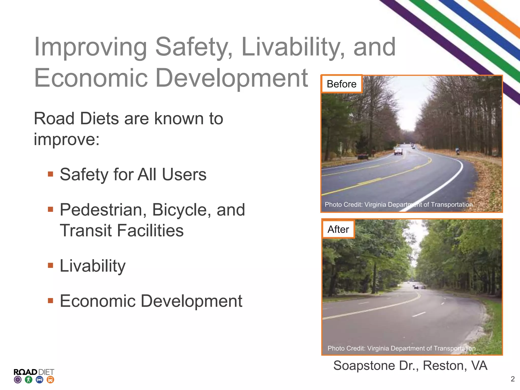
SlideShare a Scribd company logo
Improving Safety,
Livability, and
Economic Development
Jessica Rich
Federal Highway Administration
6.14.16
Improving Safety, Livability, and
Economic Development
Road Diets are known to
improve:
 Safety for All Users
 Pedestrian, Bicycle, and
Transit Facilities
 Livability
 Economic Development
2
Photo: NYCDOT
Photo: NYCDOT
Source: Randy Dittberner, VDOT
Soapstone Dr., Reston, VA
Before
After
Photo Credit: Virginia Department of Transportation
4 to 3 Lane Road Diets
AfterBefore
3
Safer Midblock Behavior
4
Road Diet Benefits:
 Reduces Conflict
 Fewer (and/or
Narrower) lanes
 Dedicated bicycle
lanes
 Wider shoulders
 Protected left turns
 Reduces aggressive
driving
Before After
Safer Intersections
Before
5
After
 Less potential crash
points
 Fewer (and/or
Narrower) lanes
 Dedicated turn lane
 Curb bulb-outs
 Pedestrian Refuge
Islands
Road Diet Benefits:
Safer Maneuvers
6
Before After
 Improved site distance
 Easier to make left turn
 Easier to see pedestrians
and bicyclists crossing
street
Road Diet Benefits:
Decrease in Top-End Speeders
Location Speed Decrease
Stone Way, Seattle, WA 10+ mph 80%
Nickerson St, Seattle, WA 10+ mph 94%
Lawyers Rd, Reston, VA 5+ mph 90%
7
Road Diets Save Lives
CMF: 0.71 (0.02)
Published: 2010
Locations: CA, IA, WA
ADT Range: 3,700 – 26,400
8
*CMF developed for 4 to 3-lane Road Diet
conversions.
4-Lane to 5-Lane 2-Lane to 3-Lane
More Example Reconfigurations
3-Lane to 3-Lane 5-Lane to 3-Lane
9
Non-Motorized Safety
Photo: Richard RettingPhoto: PeopleForBikes
Photo: PeopleForBikes
10
Multimodal
Bike Usage Increase
Stone Way, Seattle 35%
Dexter Ave, Seattle 30%
7th St, Los Angeles 200%
Transit Usage Increase
Stone Way, Seattle 35% Bus Ridership
Photo: PeopleForBikes
11
Photo: PeopleForBikes
12 - 18
Month
5 - 6
Years
Time
10s of
thousands
Millions
MoneyBenefit: Cost Savings
Vs.
Vs.
12
Improving
Safety,
Livability, and
Economic Development
Case
Studies
Photo: Richard Retting
Photo: Richard RettingPhoto: PeopleForBikes
Photo: PeopleForBikes
Genesee County, MI
14
Background
 Genesee County Metropolitan Planning Commission
(GCMPC) assessed all 4-lane roads in its jurisdiction
 Schools scattered throughout the jurisdiction
Genesee County, MI
15
Road Diet Results
 Reduced crashes by 30%
 Improved livability
“Road Diets are seen as
treatments that can be used to
keep a downtown area
‘current’ and follow the
national [livability] trends.”
~ GCMPC
Photo: GCMPC
Indianapolis Cultural Trail,
Indianapolis, IN
Background
 Cultural trail needed
expansion and completion
 Planned for future
economic development
 Desired increased shared
space for bicyclists and
pedestrians
16
Indianapolis Cultural Trail,
Indianapolis, IN
Road Diet Results
 Increased bicycle and
pedestrian traffic
 $300 million of new
development along route
17
Photo: Rundell Ernstberger Associates, LLC
Photo: Steve Greist Photography
9th Ave, Manhattan, NY
Concerns
 No bicycle lanes
 Few pedestrian
safety features
 Increased
congestion
18
Photo: NYCDOT
Before
9th Ave, Manhattan, NY
Road Diet Results
 Protected bicycle lanes
with signals
 Received ITE
Transportation Planning
Council Best Program
Award
 58% decrease in injuries
for all users
19
Photo: NYCDOTAfter
Chicago – 2020
Cycle Plan
Background
 Plan to install 100 miles
of dedicated bicycle
lanes
 Accomplished in part
with Road Diets
20
Chicago’s Plan for Expanding
Bicycle Network
Source: City of Chicago
55th St, Chicago, IL
Concerns
 Impact on bus routes
 Safely incorporating
bicycle lanes
21
55th St, Chicago, IL
22
Road Diet Results
 Reduced speeds
 Improved pedestrian
safety
 Improved livability
Source: City of Chicago
Lawrence Ave, Chicago, IL
Concerns
 Did not fit residential feel of community
 Pedestrian-car crashes count was 11 times higher
than the average Chicago street
25
Before Bicycle traffic
exceeded state
threshold for
dedicated bicycle
lane
Photo: Google
Lawrence Ave, Chicago, IL
Road Diet Results
 Reduced speeds
 Improved pedestrian and bicycle safety
 Improved livability
26
Photo: Google
After
 Promoted
economic growth
with increase in
foot traffic
Tying it All
Together
Road Diets:
 Save Lives
 Accommodate all
modes
 Expands bicycle
networks
 Increase Livability
 Promotes Economic
Growth
Photo: PeopleForBikes
27
Additional
Resources
Informational Guide Case Studies
Brochure Desk Reference
28
Contact
Information
29
Jessica Rich
FHWA, Tennessee Division
(615) 781-5788
Jessica.Rich@dot.gov
Becky Crowe
FHWA, Office of Safety
(804) 775-3381
Rebecca.Crowe@dot.gov

More Related Content

What's hot

Introduction to urban transportation
Introduction to urban transportationIntroduction to urban transportation
Introduction to urban transportation
Ali Alraouf
 
Traffic Congestion PowerPoint Presentation with Images
Traffic Congestion PowerPoint Presentation with ImagesTraffic Congestion PowerPoint Presentation with Images
Traffic Congestion PowerPoint Presentation with Images
Road Safety
 
Pedestrians
PedestriansPedestrians
traffic engineering
traffic engineeringtraffic engineering
traffic engineering
Eddy Ankit Gangani
 
Planning for sustainable urban trasport
Planning for sustainable urban trasportPlanning for sustainable urban trasport
Planning for sustainable urban trasport
JIT KUMAR GUPTA
 
Innovative intersection-ppt
Innovative intersection-pptInnovative intersection-ppt
Innovative intersection-ppt
Sierra Francisco Justo
 
Urban Transportation system - mass transit system
Urban Transportation system - mass transit systemUrban Transportation system - mass transit system
Urban Transportation system - mass transit system
Eddy Ankit Gangani
 
Introduction to transport planning
Introduction to transport planningIntroduction to transport planning
Introduction to transport planning
Dhwani Shah
 
Microscopic traffic stream model
Microscopic traffic stream modelMicroscopic traffic stream model
Microscopic traffic stream model
SAURABHKUMAR1763
 
Traffic Congestion
Traffic CongestionTraffic Congestion
Traffic Congestion
S.M. Jamil
 
Pedestrian Guidelines 20 Nov09
Pedestrian Guidelines 20 Nov09Pedestrian Guidelines 20 Nov09
Pedestrian Guidelines 20 Nov09uttipecDRAFT
 
Transportation problem with relevance to indian cities
Transportation problem with relevance to indian citiesTransportation problem with relevance to indian cities
Transportation problem with relevance to indian cities
Sailish Cephas
 
2.7 HIGHWAY TRANSPORTATION : TRAFFIC ENGINEERING (TRE) 3150611 GTU
2.7 HIGHWAY TRANSPORTATION : TRAFFIC ENGINEERING (TRE) 3150611 GTU2.7 HIGHWAY TRANSPORTATION : TRAFFIC ENGINEERING (TRE) 3150611 GTU
2.7 HIGHWAY TRANSPORTATION : TRAFFIC ENGINEERING (TRE) 3150611 GTU
VATSAL PATEL
 
An introduction to transport planning rev 1
An introduction to transport planning rev 1An introduction to transport planning rev 1
An introduction to transport planning rev 1Ronan Kearns
 
Traffic congestion and Bottlenecks - Issues and Dimensions
Traffic congestion and Bottlenecks - Issues and DimensionsTraffic congestion and Bottlenecks - Issues and Dimensions
Traffic congestion and Bottlenecks - Issues and Dimensions
Emaan Sharma
 
10 traffic calming
10 traffic calming10 traffic calming
10 traffic calming
Universiti Kebangsaan Malaysia
 
Tackling future urban mobility demand in singapore
Tackling future urban mobility demand in singaporeTackling future urban mobility demand in singapore
Tackling future urban mobility demand in singapore
Institute for Transport Studies (ITS)
 
Road marking
Road markingRoad marking
Road marking
Kapil Prashant
 
Accidents studies by ravindra c
Accidents studies by ravindra cAccidents studies by ravindra c
Accidents studies by ravindra c
Ŕąvî Bøňđ
 
Land-use transport planning
Land-use transport planning Land-use transport planning
Land-use transport planning
Bhavik A Shah
 

What's hot (20)

Introduction to urban transportation
Introduction to urban transportationIntroduction to urban transportation
Introduction to urban transportation
 
Traffic Congestion PowerPoint Presentation with Images
Traffic Congestion PowerPoint Presentation with ImagesTraffic Congestion PowerPoint Presentation with Images
Traffic Congestion PowerPoint Presentation with Images
 
Pedestrians
PedestriansPedestrians
Pedestrians
 
traffic engineering
traffic engineeringtraffic engineering
traffic engineering
 
Planning for sustainable urban trasport
Planning for sustainable urban trasportPlanning for sustainable urban trasport
Planning for sustainable urban trasport
 
Innovative intersection-ppt
Innovative intersection-pptInnovative intersection-ppt
Innovative intersection-ppt
 
Urban Transportation system - mass transit system
Urban Transportation system - mass transit systemUrban Transportation system - mass transit system
Urban Transportation system - mass transit system
 
Introduction to transport planning
Introduction to transport planningIntroduction to transport planning
Introduction to transport planning
 
Microscopic traffic stream model
Microscopic traffic stream modelMicroscopic traffic stream model
Microscopic traffic stream model
 
Traffic Congestion
Traffic CongestionTraffic Congestion
Traffic Congestion
 
Pedestrian Guidelines 20 Nov09
Pedestrian Guidelines 20 Nov09Pedestrian Guidelines 20 Nov09
Pedestrian Guidelines 20 Nov09
 
Transportation problem with relevance to indian cities
Transportation problem with relevance to indian citiesTransportation problem with relevance to indian cities
Transportation problem with relevance to indian cities
 
2.7 HIGHWAY TRANSPORTATION : TRAFFIC ENGINEERING (TRE) 3150611 GTU
2.7 HIGHWAY TRANSPORTATION : TRAFFIC ENGINEERING (TRE) 3150611 GTU2.7 HIGHWAY TRANSPORTATION : TRAFFIC ENGINEERING (TRE) 3150611 GTU
2.7 HIGHWAY TRANSPORTATION : TRAFFIC ENGINEERING (TRE) 3150611 GTU
 
An introduction to transport planning rev 1
An introduction to transport planning rev 1An introduction to transport planning rev 1
An introduction to transport planning rev 1
 
Traffic congestion and Bottlenecks - Issues and Dimensions
Traffic congestion and Bottlenecks - Issues and DimensionsTraffic congestion and Bottlenecks - Issues and Dimensions
Traffic congestion and Bottlenecks - Issues and Dimensions
 
10 traffic calming
10 traffic calming10 traffic calming
10 traffic calming
 
Tackling future urban mobility demand in singapore
Tackling future urban mobility demand in singaporeTackling future urban mobility demand in singapore
Tackling future urban mobility demand in singapore
 
Road marking
Road markingRoad marking
Road marking
 
Accidents studies by ravindra c
Accidents studies by ravindra cAccidents studies by ravindra c
Accidents studies by ravindra c
 
Land-use transport planning
Land-use transport planning Land-use transport planning
Land-use transport planning
 

Similar to Road Diet: Improving Safety, Livability, and Economic Development

Complete Freeways: Evaluation of Florida's Bicycles on Limited Access Facilit...
Complete Freeways: Evaluation of Florida's Bicycles on Limited Access Facilit...Complete Freeways: Evaluation of Florida's Bicycles on Limited Access Facilit...
Complete Freeways: Evaluation of Florida's Bicycles on Limited Access Facilit...
Project for Public Spaces & National Center for Biking and Walking
 
Safety and economic benefits of road diets 5 10
Safety and economic benefits of road diets 5 10Safety and economic benefits of road diets 5 10
Safety and economic benefits of road diets 5 10Cynthia Hoyle
 
7 reinventing streets
7 reinventing streets7 reinventing streets
7 reinventing streets
BESTGUESH
 
Making the City of Wyoming Bicycle Friendly
Making the City of Wyoming Bicycle FriendlyMaking the City of Wyoming Bicycle Friendly
Making the City of Wyoming Bicycle Friendly
wethe1ma
 
Bike Facility Design and Creating an All Ages and Abilites Network
Bike Facility Design and Creating an All Ages and Abilites NetworkBike Facility Design and Creating an All Ages and Abilites Network
Bike Facility Design and Creating an All Ages and Abilites Network
bikeed
 
Bike Facility Design and Creating an All Ages and Abilites Network
Bike Facility Design and Creating an All Ages and Abilites NetworkBike Facility Design and Creating an All Ages and Abilites Network
Bike Facility Design and Creating an All Ages and Abilites Network
bikeed
 
An All Ages and Abilities Bicycle Transportation System
An All Ages and Abilities Bicycle Transportation SystemAn All Ages and Abilities Bicycle Transportation System
An All Ages and Abilities Bicycle Transportation System
bikeed
 
The Minneapolis Bicycle Story David Peterson
The Minneapolis Bicycle Story David PetersonThe Minneapolis Bicycle Story David Peterson
The Minneapolis Bicycle Story David Peterson
Trailnet
 
Session 43: The Current State of Play on the Transportation Bill in Washingto...
Session 43: The Current State of Play on the Transportation Bill in Washingto...Session 43: The Current State of Play on the Transportation Bill in Washingto...
Session 43: The Current State of Play on the Transportation Bill in Washingto...
Sharon Roerty
 
Livable Burbank
Livable BurbankLivable Burbank
Livable Burbank
Nicholas de Wolff
 
Livable Burbank
Livable BurbankLivable Burbank
Livable Burbank
Nicholas de Wolff
 
Ward 30 bike reportv3
Ward 30 bike reportv3Ward 30 bike reportv3
Ward 30 bike reportv3bikingtoronto
 
Pacers Bike Share Final Project in SPEA
Pacers Bike Share Final Project in SPEAPacers Bike Share Final Project in SPEA
Pacers Bike Share Final Project in SPEAAnthony Watts
 
Economic Benefits of Bicycling
Economic Benefits of BicyclingEconomic Benefits of Bicycling
Economic Benefits of Bicycling
Jocelyn Bergh
 
Effland.presentation
Effland.presentationEffland.presentation
Effland.presentationTrailnet
 
"Integrating Bicycles and Transit" - Evan Corey - Oregon Active Transportatio...
"Integrating Bicycles and Transit" - Evan Corey - Oregon Active Transportatio..."Integrating Bicycles and Transit" - Evan Corey - Oregon Active Transportatio...
"Integrating Bicycles and Transit" - Evan Corey - Oregon Active Transportatio...Aaron Antrim
 
Green Mobility
Green MobilityGreen Mobility
Green Mobility
Angela Vincent, AICP
 
Davidwatsonmasccc2014
Davidwatsonmasccc2014Davidwatsonmasccc2014
Davidwatsonmasccc2014
Jen Boudrie
 
City of Chicago’s Complete Streets Policy (in search of total fabulousity)
City of Chicago’s Complete Streets Policy (in search of total fabulousity)City of Chicago’s Complete Streets Policy (in search of total fabulousity)
City of Chicago’s Complete Streets Policy (in search of total fabulousity)Center for Neighborhood Technology
 

Similar to Road Diet: Improving Safety, Livability, and Economic Development (20)

Complete Freeways: Evaluation of Florida's Bicycles on Limited Access Facilit...
Complete Freeways: Evaluation of Florida's Bicycles on Limited Access Facilit...Complete Freeways: Evaluation of Florida's Bicycles on Limited Access Facilit...
Complete Freeways: Evaluation of Florida's Bicycles on Limited Access Facilit...
 
Safety and economic benefits of road diets 5 10
Safety and economic benefits of road diets 5 10Safety and economic benefits of road diets 5 10
Safety and economic benefits of road diets 5 10
 
Bike DFW
Bike DFWBike DFW
Bike DFW
 
7 reinventing streets
7 reinventing streets7 reinventing streets
7 reinventing streets
 
Making the City of Wyoming Bicycle Friendly
Making the City of Wyoming Bicycle FriendlyMaking the City of Wyoming Bicycle Friendly
Making the City of Wyoming Bicycle Friendly
 
Bike Facility Design and Creating an All Ages and Abilites Network
Bike Facility Design and Creating an All Ages and Abilites NetworkBike Facility Design and Creating an All Ages and Abilites Network
Bike Facility Design and Creating an All Ages and Abilites Network
 
Bike Facility Design and Creating an All Ages and Abilites Network
Bike Facility Design and Creating an All Ages and Abilites NetworkBike Facility Design and Creating an All Ages and Abilites Network
Bike Facility Design and Creating an All Ages and Abilites Network
 
An All Ages and Abilities Bicycle Transportation System
An All Ages and Abilities Bicycle Transportation SystemAn All Ages and Abilities Bicycle Transportation System
An All Ages and Abilities Bicycle Transportation System
 
The Minneapolis Bicycle Story David Peterson
The Minneapolis Bicycle Story David PetersonThe Minneapolis Bicycle Story David Peterson
The Minneapolis Bicycle Story David Peterson
 
Session 43: The Current State of Play on the Transportation Bill in Washingto...
Session 43: The Current State of Play on the Transportation Bill in Washingto...Session 43: The Current State of Play on the Transportation Bill in Washingto...
Session 43: The Current State of Play on the Transportation Bill in Washingto...
 
Livable Burbank
Livable BurbankLivable Burbank
Livable Burbank
 
Livable Burbank
Livable BurbankLivable Burbank
Livable Burbank
 
Ward 30 bike reportv3
Ward 30 bike reportv3Ward 30 bike reportv3
Ward 30 bike reportv3
 
Pacers Bike Share Final Project in SPEA
Pacers Bike Share Final Project in SPEAPacers Bike Share Final Project in SPEA
Pacers Bike Share Final Project in SPEA
 
Economic Benefits of Bicycling
Economic Benefits of BicyclingEconomic Benefits of Bicycling
Economic Benefits of Bicycling
 
Effland.presentation
Effland.presentationEffland.presentation
Effland.presentation
 
"Integrating Bicycles and Transit" - Evan Corey - Oregon Active Transportatio...
"Integrating Bicycles and Transit" - Evan Corey - Oregon Active Transportatio..."Integrating Bicycles and Transit" - Evan Corey - Oregon Active Transportatio...
"Integrating Bicycles and Transit" - Evan Corey - Oregon Active Transportatio...
 
Green Mobility
Green MobilityGreen Mobility
Green Mobility
 
Davidwatsonmasccc2014
Davidwatsonmasccc2014Davidwatsonmasccc2014
Davidwatsonmasccc2014
 
City of Chicago’s Complete Streets Policy (in search of total fabulousity)
City of Chicago’s Complete Streets Policy (in search of total fabulousity)City of Chicago’s Complete Streets Policy (in search of total fabulousity)
City of Chicago’s Complete Streets Policy (in search of total fabulousity)
 

More from RPO America

RPO America Peer Exchange: Rural Transportation Planning Programs
RPO America Peer Exchange: Rural Transportation Planning ProgramsRPO America Peer Exchange: Rural Transportation Planning Programs
RPO America Peer Exchange: Rural Transportation Planning Programs
RPO America
 
Electric vehicle infrastructure in rural areas
Electric vehicle infrastructure in rural areasElectric vehicle infrastructure in rural areas
Electric vehicle infrastructure in rural areas
RPO America
 
Tennessee DOT- TEVI Plan coordination & EV
Tennessee DOT- TEVI Plan coordination & EVTennessee DOT- TEVI Plan coordination & EV
Tennessee DOT- TEVI Plan coordination & EV
RPO America
 
Electric Vehicle infrastructure planning in Rural Planning Organizations
Electric Vehicle infrastructure planning in Rural Planning OrganizationsElectric Vehicle infrastructure planning in Rural Planning Organizations
Electric Vehicle infrastructure planning in Rural Planning Organizations
RPO America
 
PEL implementation tools.pptx
PEL implementation tools.pptxPEL implementation tools.pptx
PEL implementation tools.pptx
RPO America
 
Henry Underwood, Presentation on Linking Transportation & Environment in Sout...
Henry Underwood, Presentation on Linking Transportation & Environment in Sout...Henry Underwood, Presentation on Linking Transportation & Environment in Sout...
Henry Underwood, Presentation on Linking Transportation & Environment in Sout...
RPO America
 
Cheng Yan, FHWA PEL Overview
Cheng Yan, FHWA PEL OverviewCheng Yan, FHWA PEL Overview
Cheng Yan, FHWA PEL Overview
RPO America
 
CARTS Microtransit—Innovation in Rural Mobility
CARTS Microtransit—Innovation in Rural MobilityCARTS Microtransit—Innovation in Rural Mobility
CARTS Microtransit—Innovation in Rural Mobility
RPO America
 
BCGo: Microtransit System Operating throughout Calhoun County, MI
BCGo: Microtransit System Operating throughout Calhoun County, MIBCGo: Microtransit System Operating throughout Calhoun County, MI
BCGo: Microtransit System Operating throughout Calhoun County, MI
RPO America
 
Shared. Connected. Sustainable.
Shared. Connected. Sustainable.Shared. Connected. Sustainable.
Shared. Connected. Sustainable.
RPO America
 
Microtransit and Digital Infrastructure
Microtransit and Digital InfrastructureMicrotransit and Digital Infrastructure
Microtransit and Digital Infrastructure
RPO America
 
Microtransit Planning & Implementation Lessons from the North Carolina Experi...
Microtransit Planning & Implementation Lessons from the North Carolina Experi...Microtransit Planning & Implementation Lessons from the North Carolina Experi...
Microtransit Planning & Implementation Lessons from the North Carolina Experi...
RPO America
 
Microtransit Overview: A Research Perspective
Microtransit Overview: A Research PerspectiveMicrotransit Overview: A Research Perspective
Microtransit Overview: A Research Perspective
RPO America
 
Lowcountry Go Vanpool
Lowcountry Go VanpoolLowcountry Go Vanpool
Lowcountry Go Vanpool
RPO America
 
Employment & Transportation in the Southern Georgia Region
Employment & Transportation in the Southern Georgia RegionEmployment & Transportation in the Southern Georgia Region
Employment & Transportation in the Southern Georgia Region
RPO America
 
EDDs and States: Collaborating for Success
EDDs and States: Collaborating for SuccessEDDs and States: Collaborating for Success
EDDs and States: Collaborating for Success
RPO America
 
Strengthening Partnerships Between States and Economic Development Districts
Strengthening Partnerships Between States and Economic Development DistrictsStrengthening Partnerships Between States and Economic Development Districts
Strengthening Partnerships Between States and Economic Development Districts
RPO America
 
Brownfields Tour: A Visit to Hazelwood Green & RIDC Mill 19
Brownfields Tour: A Visit to Hazelwood Green & RIDC Mill 19Brownfields Tour: A Visit to Hazelwood Green & RIDC Mill 19
Brownfields Tour: A Visit to Hazelwood Green & RIDC Mill 19
RPO America
 
The Future Started Yesterday
The Future Started Yesterday The Future Started Yesterday
The Future Started Yesterday
RPO America
 
Brownfields for Redeveloping Resilience
Brownfields for Redeveloping ResilienceBrownfields for Redeveloping Resilience
Brownfields for Redeveloping Resilience
RPO America
 

More from RPO America (20)

RPO America Peer Exchange: Rural Transportation Planning Programs
RPO America Peer Exchange: Rural Transportation Planning ProgramsRPO America Peer Exchange: Rural Transportation Planning Programs
RPO America Peer Exchange: Rural Transportation Planning Programs
 
Electric vehicle infrastructure in rural areas
Electric vehicle infrastructure in rural areasElectric vehicle infrastructure in rural areas
Electric vehicle infrastructure in rural areas
 
Tennessee DOT- TEVI Plan coordination & EV
Tennessee DOT- TEVI Plan coordination & EVTennessee DOT- TEVI Plan coordination & EV
Tennessee DOT- TEVI Plan coordination & EV
 
Electric Vehicle infrastructure planning in Rural Planning Organizations
Electric Vehicle infrastructure planning in Rural Planning OrganizationsElectric Vehicle infrastructure planning in Rural Planning Organizations
Electric Vehicle infrastructure planning in Rural Planning Organizations
 
PEL implementation tools.pptx
PEL implementation tools.pptxPEL implementation tools.pptx
PEL implementation tools.pptx
 
Henry Underwood, Presentation on Linking Transportation & Environment in Sout...
Henry Underwood, Presentation on Linking Transportation & Environment in Sout...Henry Underwood, Presentation on Linking Transportation & Environment in Sout...
Henry Underwood, Presentation on Linking Transportation & Environment in Sout...
 
Cheng Yan, FHWA PEL Overview
Cheng Yan, FHWA PEL OverviewCheng Yan, FHWA PEL Overview
Cheng Yan, FHWA PEL Overview
 
CARTS Microtransit—Innovation in Rural Mobility
CARTS Microtransit—Innovation in Rural MobilityCARTS Microtransit—Innovation in Rural Mobility
CARTS Microtransit—Innovation in Rural Mobility
 
BCGo: Microtransit System Operating throughout Calhoun County, MI
BCGo: Microtransit System Operating throughout Calhoun County, MIBCGo: Microtransit System Operating throughout Calhoun County, MI
BCGo: Microtransit System Operating throughout Calhoun County, MI
 
Shared. Connected. Sustainable.
Shared. Connected. Sustainable.Shared. Connected. Sustainable.
Shared. Connected. Sustainable.
 
Microtransit and Digital Infrastructure
Microtransit and Digital InfrastructureMicrotransit and Digital Infrastructure
Microtransit and Digital Infrastructure
 
Microtransit Planning & Implementation Lessons from the North Carolina Experi...
Microtransit Planning & Implementation Lessons from the North Carolina Experi...Microtransit Planning & Implementation Lessons from the North Carolina Experi...
Microtransit Planning & Implementation Lessons from the North Carolina Experi...
 
Microtransit Overview: A Research Perspective
Microtransit Overview: A Research PerspectiveMicrotransit Overview: A Research Perspective
Microtransit Overview: A Research Perspective
 
Lowcountry Go Vanpool
Lowcountry Go VanpoolLowcountry Go Vanpool
Lowcountry Go Vanpool
 
Employment & Transportation in the Southern Georgia Region
Employment & Transportation in the Southern Georgia RegionEmployment & Transportation in the Southern Georgia Region
Employment & Transportation in the Southern Georgia Region
 
EDDs and States: Collaborating for Success
EDDs and States: Collaborating for SuccessEDDs and States: Collaborating for Success
EDDs and States: Collaborating for Success
 
Strengthening Partnerships Between States and Economic Development Districts
Strengthening Partnerships Between States and Economic Development DistrictsStrengthening Partnerships Between States and Economic Development Districts
Strengthening Partnerships Between States and Economic Development Districts
 
Brownfields Tour: A Visit to Hazelwood Green & RIDC Mill 19
Brownfields Tour: A Visit to Hazelwood Green & RIDC Mill 19Brownfields Tour: A Visit to Hazelwood Green & RIDC Mill 19
Brownfields Tour: A Visit to Hazelwood Green & RIDC Mill 19
 
The Future Started Yesterday
The Future Started Yesterday The Future Started Yesterday
The Future Started Yesterday
 
Brownfields for Redeveloping Resilience
Brownfields for Redeveloping ResilienceBrownfields for Redeveloping Resilience
Brownfields for Redeveloping Resilience
 

Recently uploaded

Getting started with Amazon Bedrock Studio and Control Tower
Getting started with Amazon Bedrock Studio and Control TowerGetting started with Amazon Bedrock Studio and Control Tower
Getting started with Amazon Bedrock Studio and Control Tower
Vladimir Samoylov
 
Sharpen existing tools or get a new toolbox? Contemporary cluster initiatives...
Sharpen existing tools or get a new toolbox? Contemporary cluster initiatives...Sharpen existing tools or get a new toolbox? Contemporary cluster initiatives...
Sharpen existing tools or get a new toolbox? Contemporary cluster initiatives...
Orkestra
 
somanykidsbutsofewfathers-140705000023-phpapp02.pptx
somanykidsbutsofewfathers-140705000023-phpapp02.pptxsomanykidsbutsofewfathers-140705000023-phpapp02.pptx
somanykidsbutsofewfathers-140705000023-phpapp02.pptx
Howard Spence
 
Competition and Regulation in Professional Services – KLEINER – June 2024 OEC...
Competition and Regulation in Professional Services – KLEINER – June 2024 OEC...Competition and Regulation in Professional Services – KLEINER – June 2024 OEC...
Competition and Regulation in Professional Services – KLEINER – June 2024 OEC...
OECD Directorate for Financial and Enterprise Affairs
 
Acorn Recovery: Restore IT infra within minutes
Acorn Recovery: Restore IT infra within minutesAcorn Recovery: Restore IT infra within minutes
Acorn Recovery: Restore IT infra within minutes
IP ServerOne
 
International Workshop on Artificial Intelligence in Software Testing
International Workshop on Artificial Intelligence in Software TestingInternational Workshop on Artificial Intelligence in Software Testing
International Workshop on Artificial Intelligence in Software Testing
Sebastiano Panichella
 
Announcement of 18th IEEE International Conference on Software Testing, Verif...
Announcement of 18th IEEE International Conference on Software Testing, Verif...Announcement of 18th IEEE International Conference on Software Testing, Verif...
Announcement of 18th IEEE International Conference on Software Testing, Verif...
Sebastiano Panichella
 
Bonzo subscription_hjjjjjjjj5hhhhhhh_2024.pdf
Bonzo subscription_hjjjjjjjj5hhhhhhh_2024.pdfBonzo subscription_hjjjjjjjj5hhhhhhh_2024.pdf
Bonzo subscription_hjjjjjjjj5hhhhhhh_2024.pdf
khadija278284
 
Eureka, I found it! - Special Libraries Association 2021 Presentation
Eureka, I found it! - Special Libraries Association 2021 PresentationEureka, I found it! - Special Libraries Association 2021 Presentation
Eureka, I found it! - Special Libraries Association 2021 Presentation
Access Innovations, Inc.
 
Obesity causes and management and associated medical conditions
Obesity causes and management and associated medical conditionsObesity causes and management and associated medical conditions
Obesity causes and management and associated medical conditions
Faculty of Medicine And Health Sciences
 
Bitcoin Lightning wallet and tic-tac-toe game XOXO
Bitcoin Lightning wallet and tic-tac-toe game XOXOBitcoin Lightning wallet and tic-tac-toe game XOXO
Bitcoin Lightning wallet and tic-tac-toe game XOXO
Matjaž Lipuš
 
Doctoral Symposium at the 17th IEEE International Conference on Software Test...
Doctoral Symposium at the 17th IEEE International Conference on Software Test...Doctoral Symposium at the 17th IEEE International Conference on Software Test...
Doctoral Symposium at the 17th IEEE International Conference on Software Test...
Sebastiano Panichella
 
0x01 - Newton's Third Law: Static vs. Dynamic Abusers
0x01 - Newton's Third Law:  Static vs. Dynamic Abusers0x01 - Newton's Third Law:  Static vs. Dynamic Abusers
0x01 - Newton's Third Law: Static vs. Dynamic Abusers
OWASP Beja
 

Recently uploaded (13)

Getting started with Amazon Bedrock Studio and Control Tower
Getting started with Amazon Bedrock Studio and Control TowerGetting started with Amazon Bedrock Studio and Control Tower
Getting started with Amazon Bedrock Studio and Control Tower
 
Sharpen existing tools or get a new toolbox? Contemporary cluster initiatives...
Sharpen existing tools or get a new toolbox? Contemporary cluster initiatives...Sharpen existing tools or get a new toolbox? Contemporary cluster initiatives...
Sharpen existing tools or get a new toolbox? Contemporary cluster initiatives...
 
somanykidsbutsofewfathers-140705000023-phpapp02.pptx
somanykidsbutsofewfathers-140705000023-phpapp02.pptxsomanykidsbutsofewfathers-140705000023-phpapp02.pptx
somanykidsbutsofewfathers-140705000023-phpapp02.pptx
 
Competition and Regulation in Professional Services – KLEINER – June 2024 OEC...
Competition and Regulation in Professional Services – KLEINER – June 2024 OEC...Competition and Regulation in Professional Services – KLEINER – June 2024 OEC...
Competition and Regulation in Professional Services – KLEINER – June 2024 OEC...
 
Acorn Recovery: Restore IT infra within minutes
Acorn Recovery: Restore IT infra within minutesAcorn Recovery: Restore IT infra within minutes
Acorn Recovery: Restore IT infra within minutes
 
International Workshop on Artificial Intelligence in Software Testing
International Workshop on Artificial Intelligence in Software TestingInternational Workshop on Artificial Intelligence in Software Testing
International Workshop on Artificial Intelligence in Software Testing
 
Announcement of 18th IEEE International Conference on Software Testing, Verif...
Announcement of 18th IEEE International Conference on Software Testing, Verif...Announcement of 18th IEEE International Conference on Software Testing, Verif...
Announcement of 18th IEEE International Conference on Software Testing, Verif...
 
Bonzo subscription_hjjjjjjjj5hhhhhhh_2024.pdf
Bonzo subscription_hjjjjjjjj5hhhhhhh_2024.pdfBonzo subscription_hjjjjjjjj5hhhhhhh_2024.pdf
Bonzo subscription_hjjjjjjjj5hhhhhhh_2024.pdf
 
Eureka, I found it! - Special Libraries Association 2021 Presentation
Eureka, I found it! - Special Libraries Association 2021 PresentationEureka, I found it! - Special Libraries Association 2021 Presentation
Eureka, I found it! - Special Libraries Association 2021 Presentation
 
Obesity causes and management and associated medical conditions
Obesity causes and management and associated medical conditionsObesity causes and management and associated medical conditions
Obesity causes and management and associated medical conditions
 
Bitcoin Lightning wallet and tic-tac-toe game XOXO
Bitcoin Lightning wallet and tic-tac-toe game XOXOBitcoin Lightning wallet and tic-tac-toe game XOXO
Bitcoin Lightning wallet and tic-tac-toe game XOXO
 
Doctoral Symposium at the 17th IEEE International Conference on Software Test...
Doctoral Symposium at the 17th IEEE International Conference on Software Test...Doctoral Symposium at the 17th IEEE International Conference on Software Test...
Doctoral Symposium at the 17th IEEE International Conference on Software Test...
 
0x01 - Newton's Third Law: Static vs. Dynamic Abusers
0x01 - Newton's Third Law:  Static vs. Dynamic Abusers0x01 - Newton's Third Law:  Static vs. Dynamic Abusers
0x01 - Newton's Third Law: Static vs. Dynamic Abusers
 

Road Diet: Improving Safety, Livability, and Economic Development

  • 1. Improving Safety, Livability, and Economic Development Jessica Rich Federal Highway Administration 6.14.16
  • 2. Improving Safety, Livability, and Economic Development Road Diets are known to improve:  Safety for All Users  Pedestrian, Bicycle, and Transit Facilities  Livability  Economic Development 2 Photo: NYCDOT Photo: NYCDOT Source: Randy Dittberner, VDOT Source: Randy Dittberner, VDOT Soapstone Dr., Reston, VA Before After Photo Credit: Virginia Department of Transportation Photo Credit: Virginia Department of Transportation
  • 3. 4 to 3 Lane Road Diets AfterBefore 3
  • 4. Safer Midblock Behavior 4 Road Diet Benefits:  Reduces Conflict  Fewer (and/or Narrower) lanes  Dedicated bicycle lanes  Wider shoulders  Protected left turns  Reduces aggressive driving Before After
  • 5. Safer Intersections Before 5 After  Less potential crash points  Fewer (and/or Narrower) lanes  Dedicated turn lane  Curb bulb-outs  Pedestrian Refuge Islands Road Diet Benefits:
  • 6. Safer Maneuvers 6 Before After  Improved site distance  Easier to make left turn  Easier to see pedestrians and bicyclists crossing street Road Diet Benefits:
  • 7. Decrease in Top-End Speeders Location Speed Decrease Stone Way, Seattle, WA 10+ mph 80% Nickerson St, Seattle, WA 10+ mph 94% Lawyers Rd, Reston, VA 5+ mph 90% 7
  • 8. Road Diets Save Lives CMF: 0.71 (0.02) Published: 2010 Locations: CA, IA, WA ADT Range: 3,700 – 26,400 8 *CMF developed for 4 to 3-lane Road Diet conversions.
  • 9. 4-Lane to 5-Lane 2-Lane to 3-Lane More Example Reconfigurations 3-Lane to 3-Lane 5-Lane to 3-Lane 9
  • 10. Non-Motorized Safety Photo: Richard RettingPhoto: PeopleForBikes Photo: PeopleForBikes 10
  • 11. Multimodal Bike Usage Increase Stone Way, Seattle 35% Dexter Ave, Seattle 30% 7th St, Los Angeles 200% Transit Usage Increase Stone Way, Seattle 35% Bus Ridership Photo: PeopleForBikes 11 Photo: PeopleForBikes
  • 12. 12 - 18 Month 5 - 6 Years Time 10s of thousands Millions MoneyBenefit: Cost Savings Vs. Vs. 12
  • 13. Improving Safety, Livability, and Economic Development Case Studies Photo: Richard Retting Photo: Richard RettingPhoto: PeopleForBikes Photo: PeopleForBikes
  • 14. Genesee County, MI 14 Background  Genesee County Metropolitan Planning Commission (GCMPC) assessed all 4-lane roads in its jurisdiction  Schools scattered throughout the jurisdiction
  • 15. Genesee County, MI 15 Road Diet Results  Reduced crashes by 30%  Improved livability “Road Diets are seen as treatments that can be used to keep a downtown area ‘current’ and follow the national [livability] trends.” ~ GCMPC Photo: GCMPC
  • 16. Indianapolis Cultural Trail, Indianapolis, IN Background  Cultural trail needed expansion and completion  Planned for future economic development  Desired increased shared space for bicyclists and pedestrians 16
  • 17. Indianapolis Cultural Trail, Indianapolis, IN Road Diet Results  Increased bicycle and pedestrian traffic  $300 million of new development along route 17 Photo: Rundell Ernstberger Associates, LLC Photo: Steve Greist Photography
  • 18. 9th Ave, Manhattan, NY Concerns  No bicycle lanes  Few pedestrian safety features  Increased congestion 18 Photo: NYCDOT Before
  • 19. 9th Ave, Manhattan, NY Road Diet Results  Protected bicycle lanes with signals  Received ITE Transportation Planning Council Best Program Award  58% decrease in injuries for all users 19 Photo: NYCDOTAfter
  • 20. Chicago – 2020 Cycle Plan Background  Plan to install 100 miles of dedicated bicycle lanes  Accomplished in part with Road Diets 20 Chicago’s Plan for Expanding Bicycle Network Source: City of Chicago
  • 21. 55th St, Chicago, IL Concerns  Impact on bus routes  Safely incorporating bicycle lanes 21
  • 22. 55th St, Chicago, IL 22 Road Diet Results  Reduced speeds  Improved pedestrian safety  Improved livability Source: City of Chicago
  • 23. Lawrence Ave, Chicago, IL Concerns  Did not fit residential feel of community  Pedestrian-car crashes count was 11 times higher than the average Chicago street 25 Before Bicycle traffic exceeded state threshold for dedicated bicycle lane Photo: Google
  • 24. Lawrence Ave, Chicago, IL Road Diet Results  Reduced speeds  Improved pedestrian and bicycle safety  Improved livability 26 Photo: Google After  Promoted economic growth with increase in foot traffic
  • 25. Tying it All Together Road Diets:  Save Lives  Accommodate all modes  Expands bicycle networks  Increase Livability  Promotes Economic Growth Photo: PeopleForBikes 27
  • 26. Additional Resources Informational Guide Case Studies Brochure Desk Reference 28
  • 27. Contact Information 29 Jessica Rich FHWA, Tennessee Division (615) 781-5788 Jessica.Rich@dot.gov Becky Crowe FHWA, Office of Safety (804) 775-3381 Rebecca.Crowe@dot.gov

Editor's Notes

  1. We’re going to talking about a relatively inexpensive tool that has been shown to improve safety, livability, and economic development. This tool focuses on converting undivided roads (which contain a large number of potential crash points) to a safer type of cross-section. (JEN’S NOTE: while “right-sizing” the roadway for traffic needs (vehicles, peds, bikes, transit, etc.), to help make streets more “complete”, and spurring economic growth and corridor appeal)
  2. In a nutshell, Road Diets reallocate space to better met the needs of the users, and in doing so, improve safety for all users. Today we’ll talk about how Road Diets improve safety, and then how that safety improvement translates to increased livability and economic development in the surrounding area. These images are of before and after a Road Diet was implemented on Soapstone Dr. in Reston, VA. The Road Diet reallocated space to add dedicated bicycle lanes and encourage drivers to slow down.
  3. A typical Road diet converts 4 through lanes to two through lanes with a TWLTL.
  4. Road Diets provide a safer cross-section mid-block with: Reduces Number of Conflict Points: Cuts them in half. Fewer (and/or Narrower) lanes: Many think that Road Diets mean narrower lanes, but typically, lane width stays the same, while the number of lanes decrease.  This gives a shorter crossing distance. Calms traffic.    Dedicated bicycle lanes: Removes bicyclists from motor-vehicle lanes. Wider shoulders: More space between pedestrians on sidewalk and traffic. Can also provide more “recovery area” for vehicles if they depart their lane and allow for area to pull off the road for law enforcement, mail delivery, car trouble, etc. Protected left turns: By taking the left turning vehicles out of the through lane, reduces likelihood of collisions, especially rear-end crashes Reduces aggressive driving: With one through lane, aggressive drivers are unable to weave in and out. Also, speeding drivers are forced to travel behind more reasonable drivers.
  5. At intersections, safety is improved by: Less potential crash points: Conflict points are reduced. Fewer (and/or Narrower) lanes: Shorter crossing distance. Calms traffic. Dedicated left turn lane and/or right turn lane: Space may be used for a left turn lane or a right turn lane or both. Curb bulb-outs: Agencies could choose to use the extra space at intersections to construct bulb-outs which position pedestrians in a better location to view traffic if there is parking along the corridor. Pedestrian Refuge Islands: Extra space can be used to create pedestrian or median refuge islands that are placed in the center of the street to facilitate safe crossings.  Pedestrians only have to negotiate one direction of traffic at a time.
  6. Improved site distance: Multiple lanes of traffic can cause blind spots for turning vehicles. Easier to make left turn: It feels safer and more comfortable to execute a turn across one lane of traffic rather than multiple lanes of traffic. Easier to see pedestrians and bicyclists crossing street: With less lanes of traffic, it is easier to spot these users.
  7. Road Diets also improve safety by reducing top-end speeders (motorists traveling 5 or 10 mph and greater over the speed limit). Lower speeds can help road users avoid a crash and are linked with less severe crashes when crashes do occur. Many Road Diets reduce the number of through lanes per direction from 2 to 1, which helps control speeds by establishing the pace of a lead vehicle. Lane narrowing alone has also been shown to slow vehicles down. Drivers must pay more attention (and by doing so unintentionally slow down) in order to stay within their lane. In these case studies, the average speed remained the same and was around the speed limit, but the number of top-end speeders dropped dramatically. Source: http://safety.fhwa.dot.gov/road_diets/case_studies/roaddiet_cs.pdf
  8. All of these safety improvements culminate in a significantly large (and measurable) crash reduction. FHWA completed a study in 2004 called Evaluation of Lane Reduction "Road Diet" Measures on Crashes” that evaluated Road Diet treatments in California and Washington. In 2010, the Highway Safety Information System re-examined the data in the earlier study using more advanced study techniques and adds an analysis of Road Diet sites in smaller urban communities in Iowa. HSIS Study: https://www.fhwa.dot.gov/publications/research/safety/10053/ Publication Number: FHWA-HRT-10-053 Date: June 2010 Evaluation of Lane Reduction "Road Diet" Measures on Crashes
  9. So far, we have mostly talked about 4 to 3 lane Road Diets, but this is not the only type of Road Diet… A Road Diet is generally described as the reallocation of roadway space in order to improve safety and/or make space for other travel modes. This can include: Lane narrowing to accommodate TWLTL (4 to 5 lane and 2 to 3 lane) Lane narrowing to make space for shoulders or bike/ped facilities (3 to 3 lane) Lane reduction to make space for shoulders, parking, or bike/ped facilities (5 to 3 lane) What all these road diets have in common is that they reallocate the given roadway space to better meet the needs of the users. In doing so, they improve safety.
  10. Road Diets not only improve motorized safety, but can also improve non-motorized safety as well. Road Diets are one of the tools used to accomplish Complete Streets. They can be used to improve pedestrian and bicycle safety by adding: Dedicated bicycle lanes Pedestrian refuge islands Medians TWLTL Shoulders Sidewalks
  11. Numerous case studies have shown that when pedestrians and bicyclist feel safer, they are more likely to walk or bike. The case studies on the slide measured before and after bicycle ridership along the corridor and saw large increase (30 – 200%) after a Road Diet adding dedicated bicycle lanes was implemented. None of these locations had dedicated bicycle lanes previously. Stone Way – Before: no bike lanes. After: designated bike lanes. Dexter Ave – Before: bike lanes were combined with parking lane. After: dedicated bike lane with a paved median; dedicated parking lane. 7th St – Before: no bike lanes or parking. After, dedicated bike lanes and dedicated parking lanes. Source: http://safety.fhwa.dot.gov/road_diets/case_studies/roaddiet_cs.pdf
  12. Road Diets are relatively inexpensive. They provide improved safety and comfort for all road users at a low cost compared with other countermeasures. If a Road Diet is not used, adding bicycle lanes or improved pedestrian facility may require purchasing right-of-way and roadway reconstruction. Road Diets cost on the order of 10s of thousands of dollars per mile depending on the chosen features, compared to millions of dollars per mile for a road reconstruction project involving right-of-way. Road Diets are also a relatively expedient solution. They use existing right-of-way which can expedite the entire project. From idea to implementation, Road Diets take approximately 12 – 18 months, including getting public involvement. Compare this to 5-6 years for a road reconstruction project that might involve buying additional ROW to add wider sidewalks, turn lanes, bike lanes, or on-street parking.
  13. So far, we’ve abstractly discussed how Road Diets can improve safety. Now, let’s walk through some concrete examples of how Road Diets are being used to improve safety, livability, and economic development.
  14. This is an example of a Metropolitan Planning Commission that proactively tried to incorporate Road Diets within their jurisdiction. In 2009 Genesee County Metropolitan Planning Commission (GCMPC) completed a technical study and assessed every 4-lane road in within its jurisdiction (comprised of 1 county and 33 of its municipalities), for potential conversion to 3 lanes. In the beginning, routes with lower volumes (6,000 to 8,000 vehicles per day) were targeted in order to allow for easy conversion, and the results included immediate safety benefits. After several successful conversions with positive outcomes, GCMPC began selecting implementation sites with higher volumes – up to 15,000 vehicles per day. GCMPC has encouraged local agencies in the county to try out Road Diets by restriping existing 4-lane segments to three lanes as part of their ongoing restriping plans. After a trial period, if the conversion is not operating as desired or publicly accepted, the road can be restriped back to the original layout.
  15. The Road Diet installations have improved safety in Genesee County. GCMPC completed a before-and-after crash safety using data from 1996 to 2007 at seven Road Diet sites and found an approximate 30% reduction of crashes overall. GCMPC has also seen Road Diets improve the livability of the surround area. They view Road Diets as “treatments that can be used to keep a downtown area ‘current’ and follow the national [livability] trends.” Road Diets have rapidly become culturally accepted in Michigan, and agencies are scouring their systems to identify which 4-lane roads are the best candidates for a Road Diet. GCMPC has been both progressive and aggressive with Road Diet installations. Since the introduction of this safety treatment to the public, the GCMPC set out to make Road Diets a positive treatment in the community’s eyes. The 4- to 3-lane Road Diet conversions in the county have been so successful that citizens now favor the 3-lane cross section where it is operationally feasible.
  16. The City of Indianapolis, through a public-private partnership, sought to complete the Indianapolis Cultural Trail, an 8-mile biking and walking trail system that connects the cultural districts, neighborhoods, and the city’s greenway system. In order to complete this trail system, streets in downtown Indianapolis underwent Road Diets. Central Indiana Community Foundation (CICF) and the Mayor of Indianapolis envisioned that by providing improved multi-modal connectivity throughout Indianapolis’ cultural districts and historic neighborhoods, economic development in the area would improve. The streets in downtown Indianapolis were mostly five or six lanes wide, and speeds could reach close to 50 mph. The design team reduced both the number of lanes and lane widths as a way of both slowing speeds and gaining extra space within the right of way to allow for the separate pedestrian and bicyclist trail. The completed trail loops around downtown and connects to greenways with two spurs. The trail includes shared space for bicyclists and pedestrians, and some areas incorporate two separate facilities for pedestrians and bicyclists.
  17. Improving safety for all users was one of the project team’s goals. In addition to the traffic calming effect the Road Diets provided, the design also included other safety features, such as curb bulb-outs at intersections to reduce crossing distance, chicanes in the bicycle facilities to alert bicyclists of an upcoming intersection, and countdown timers and audible pedestrian signals. This innovative redesign of the area has improved economic development and has brought a significant increase in pedestrian and bicycle traffic to downtown Indianapolis as people of all ages and abilities have embraced the trail. Although the last phase of the trail was not completed until the end of 2012, new construction and redevelopment started happening in the area well before the project was finished. Over $300 million of new development has been constructed along the route since 2008. While tax assessment data from 2007-2010 from nearby areas decreased by 1.2 percent, the assessed value along the Cultural Trail showed a small increase.
  18. In 2007, New York City Department of Transportation (NYCDOT) implemented a Road Diet that completely redesigned 9th Avenue. Prior to the reconfiguration, 9th Avenue, a one-way street, consisted of four through lanes with parking on both sides, but no bicycle facilities and few pedestrian safety features. Located within a very active and dense, mixed-use, central business district, with close proximity to the New York Institute of Technology, the 9th Avenue Road Diet extended from West 23rd Street to West 16th Street. NYCDOT’s primary project goal was to create a safe street that would accommodate all road users. During the planning and design process, NYCDOT communicated openly to determine potential issues and address concerns from the community. The design considered the needs of all street users, including bicyclists, pedestrians, motorists, and bus riders.
  19. The design included: One less motor-vehicle travel lane Bicycle lanes placed between the parking lane and sidewalk, creating a safe and comfortable atmosphere for bicyclists. This included bicycle lane traffic signals and signal optimization. Pedestrian refuge islands, narrowing the crossing distance of 9th Avenue Preserved parking In 2008, the Institute of Transportation Engineers (ITE) awarded the creativity of NYCDOT’s Road Diet project on 9th Avenue with the Transportation Planning Council Best Program Award. The project’s success was later confirmed in 2012 when NYCDOT reported a 58 percent decrease in injuries to all street users.
  20. In 2011, Chicago’s mayor announced the Streets for Cycling Plan 2020. With this plan, by 2015, 100 miles of barrier and buffer protected bicycle lanes will be installed, with an additional 50 miles by 2020. The primary tool for meeting the 100 mile goal is Road Diets. To tap into the local knowledge held by Chicagoans, nine Community Advisory Groups (CAGs) were formed in separate sections of the city. Each CAG consisted of two or three volunteer leaders who organized monthly meetings to obtain input on each phase of the project. The CAGs were asked to identify the best streets for future on-street bikeways in their section of the city. Source: http://www.cityofchicago.org/content/dam/city/depts/cdot/bike/general/ChicagoStreetsforCycling2020.pdf
  21. Chicago’s 2020 Cycling Plan was the starting point that led to the Road Diet on 55th Street. Barrier protected bike lanes were installed on 55th Street in the Hyde park neighborhood, between Cottage Grove Avenue and Dorchester Avenue, in July 2012. Prior to the project, this stretch of 55th Street was 5-lanes with two travel lanes in each direction and a center left-turn lane at some intersections. The Chicago Transit Authority (CTA) has a primary bus route along this corridor, with headways ranging from 5 to 20 minutes throughout the day. The city coordinated extensively with the CTA on the design of the Road Diet. The overall design and layout of the bus stops in coordination with the separated bicycle lanes was a critical issue to maintain efficient bus operation.
  22. The average daily traffic on 55th Street is approximately 16,000, well below the capacity of a 4-lane roadway. 55th Street was uninviting for pedestrians and bicyclists due to the width of the street and lack of bicycle accommodations. As a result of the 55th Street Road Diet: Speeding had been an issue on the corridor prior to the Road Diet, but since the conversion, drivers have been closely adhering to the 30 mph speed limit. With less crossing lanes, the Road Diet has made it easier and faster for pedestrians to cross 55th Street at intersecting roadways. The community expressed that the Road Diet has benefited livability. Since 55th Street runs along the University of Chicago campus, the addition of bicycle lanes was a great advantage to students, staff, and visitors.
  23. In the late 1930s, the City of San Francisco had grand plans to build a third bridge across the San Francisco Bay. In anticipation that it would eventually connect to this new bridge, the city widened Cesar Chavez St from two lanes to six, and designed it to carry up to 53,000 vehicles per day. 80 years later their bridge dreams have never been realized—and the arterial was in sore need of an update. In recent years, the street had all the problems one would expect from a major arterial in a dense urban area: high traffic speeds, many crashes, and the feeling of a divided city. Crossing the road by foot was treacherous, and over the course of just five years there were approximately 150 crashes along the street. People on foot and bicycle accounted for 8 and 15 percent of the crashes, respectively, even though they accounted for a much smaller percentage of the overall traffic. Community members wanted a street that functioned for all users, and in 2008, the City of San Francisco began community meetings to plan improvements. When the City announced plans to upgrade the sewer system and repave the street, community leaders successfully pushed for safety and aesthetic improvements. Once the street plans were finalized by the San Francisco Planning Department and the San Francisco Municipal Transportation Agency, San Francisco’s Department of Public Works (DPW) worked with the City’s Public Utility Commission to coordinate the sewer and street projects. Source: http://www.smartgrowthamerica.org/2015/07/30/change-in-plans/
  24. After two years of public meetings and workshops, the City and community members reached consensus that the six traffic lanes and two parking lanes would be converted to four or five traffic lanes, with wider parking lanes, bulb-outs, bicycle lanes, and a 12- to 14-foot center median—even though this would mean an “F” grade for Level of Service, an traffic engineering metric to measure delay to motorists. The lane reduction has slowed traffic, with some of that width dedicated to landscaped medians. People walking along the street now find plazas, and when they cross, they find refuges and curb extensions to shorten crossing distances. Nearly every intersection received bulb-outs that shorten crossing distances for people on foot. (In one section of the Cesar Chavez, the crossing distance was shortened from 125 to 68 feet) Signal timing and phasing has been changed to give pedestrians more time to cross and to reduce conflicts between turning cars and people on foot. Left-turns were also restricted in places that had seen a high frequency of crashes. In addition to the improvements for pedestrians, new bicycle lanes provide separate space for bicyclists and reduce conflicts with cars and trucks. As a result, bicycle counts on Cesar Chavez shot up by over 400 percent after the project was completed. The drivers of cars and freight trucks benefit from left turn lanes and wider parking lanes. Bus congestion was also ameliorated through the addition of transit bulb-outs, which expand the sidewalk to allow for larger bus shelters and tree-covered waiting areas. The addition of bicycle parking at some bus stops help those cycling transfer to their bus. The Institute of Transportation Engineers’s San Francisco Bay Area group chose it as the Transportation Project of 2014. It also was awarded the Best Pedestrian/Bicycle Project of the year by the California Transportation Foundation, ahead of 98 other nominations from around the state.
  25. A road diet, bicycle lanes, and a profusion of pedestrian improvements have subtly transformed the neighborhood surrounding Lawrence Ave. Today, the neighborhood has a quiet, residential feel. Six bus routes and two train lines serve the neighborhood, and ridership rates are high. Buildings in the neighborhood are at most only three or four stories high, and that area services a pharmacy, grocery store, handful of boutiques, and cafes. Until recently, Lawrence Avenue didn’t fit the low-key character of the community. A one-mile stretch of the road had four travel lanes and parking, but was bookended by a two-lane configuration. Drivers tended to blast through the four-lane section of the street. Long distances between crosswalks made it difficult for people to cross safely between the bus stops, businesses, parks, elementary school, social services agencies, and apartment buildings that line the corridor. 72 people were injured in pedestrian-car crashes along Lawrence Avenue between 2005 and 2012. That’s 11 times higher than the average Chicago street. Bicycle traffic on the street also exceeded state standards for when to introduce a dedicated bicycle lane. Chicago’s aldermen, elected representatives from 50 city wards, are responsible for directing and financing street improvements. In Ravenswood’s case, Alderman Ameya Pawar took the lead and worked with the Chicago Department of Transportation (CDOT)’s Livable Streets program in transforming Lawrence to a safe and attractive street. In addition, CDOT coordinated with the City of Chicago’s Department of Water Management to update the stormwater system along Lawrence. Each of the 13 curb extensions has an opening for storm water. A new system of catch basins and underdrains was installed to collect any overflow from the curb-outs and funnel it into drainage pipes. The upgraded stormwater system will help prevent flooding during rainy days and ease the burden on the city’s combined sewer system. Source: http://www.smartgrowthamerica.org/2015/08/27/just-the-right-size/
  26. Chicago Department of Transportation (CDOT) began construction on Lawrence Avenue in 2013, reducing the four-lane section of the street to two lanes, adding bicycle lanes in both directions, and a center turn lane. CDOT also added 11 pedestrian refuges, extended the sidewalk by 5 feet, and added 6 curb extensions. To slow any cut-through traffic, an additional seven curb extensions were added to side streets immediately adjacent to Lawrence. A brick-pattern was added to the crosswalks with a stamped thermoplastic layer, creating a distinct and attractive space for pedestrians. The bicycle lanes replaced shared lane markings, completing a five-mile link to Lake Michigan and creating Chicago’s longest east-west bicycle route. The improvements to the walking and bicycling environment are a boon for the stores and restaurants on Lawrence. The improvements have made it more desirable for businesses because of the additional foot traffic
  27. FHWA Road Diet resources available online… FHWA flyers currently in development: Road Diet Myth Busters Capacity Flyer How to Select a Candidate Location for a Road Diet Road Diet Evaluation metrics Incorporating Road Diets into Policy Road Diets and EMS Response Road Diet Cost For more information about these or for Road Diet related Technical Assistance, contact Becky Crowe.