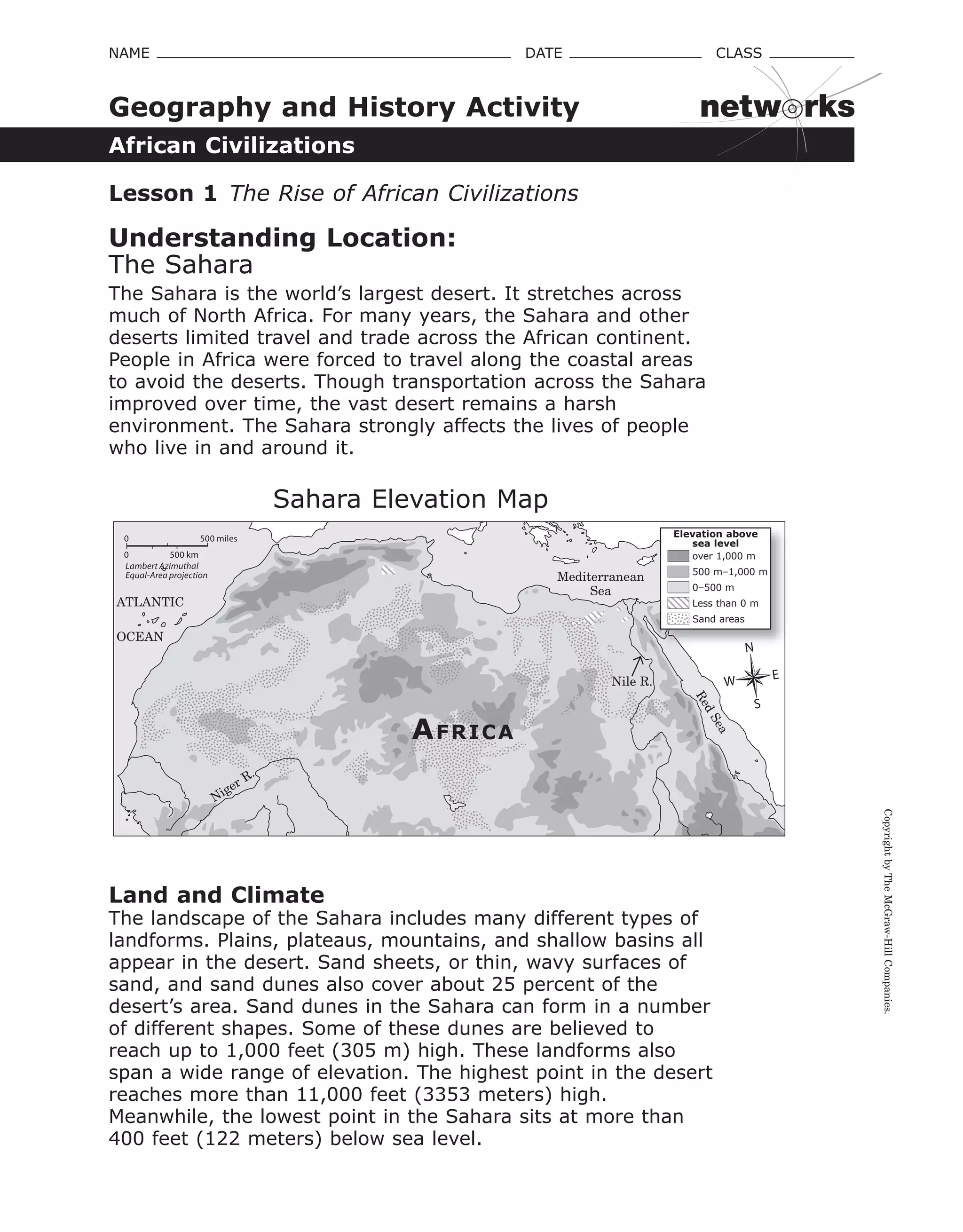
CopyrightbyTheMcGraw-HillCompanies.
NAME    DATE    CLASS 
African Civilizations
Geography and History Activity
Lesson 1  The Rise of African Civilizations
Understanding Location: 
The Sahara
The Sahara is the world’s largest desert. It stretches across
much of North Africa. For many years, the Sahara and other
deserts limited travel and trade across the African continent.
People in Africa were forced to travel along the coastal areas
to avoid the deserts. Though transportation across the Sahara
improved over time, the vast desert remains a harsh
environment. The Sahara strongly affects the lives of people
who live in and around it.
Sahara Elevation Map
0
Lambert Azimuthal
Equal-Area projection
500 km
500 miles0
N
S
E
W
N
KEY
over 1,000m
500m–1,000m
0–500m
Less than 0m
Sand areas
ring our Past - World)
ahara
L1_wsgh_01A.ai
x 18p6
10, 2011 - First Proof
ATLANTIC
OCEAN
Africa
Niger R.
RedSea
Nile R.
Mediterranean
Sea
Elevation above
sea level
over 1,000 m
500 m–1,000 m
0–500 m
Less than 0 m
Sand areas
Land and Climate
The landscape of the Sahara includes many different types of
landforms. Plains, plateaus, mountains, and shallow basins all
appear in the desert. Sand sheets, or thin, wavy surfaces of
sand, and sand dunes also cover about 25 percent of the
desert’s area. Sand dunes in the Sahara can form in a number
of different shapes. Some of these dunes are believed to
reach up to 1,000 feet (305 m) high. These landforms also
span a wide range of elevation. The highest point in the desert
reaches more than 11,000 feet (3353 meters) high.
Meanwhile, the lowest point in the Sahara sits at more than
400 feet (122 meters) below sea level.
netw rks
CopyrightbyTheMcGraw-HillCompanies.
NAME    DATE    CLASS 
African Civilizations
Geography and History Activity  Cont.
Scientists believe that the area of the Sahara has had a desert
climate for about five million years. The Sahara averages only
a few inches of precipitation a year. Temperatures can vary a
great deal, even within the same day. In the northern part of
the Sahara, the average low temperature is around 36 ºF  
(20 ºC). High temperatures in the summer months have
reached as hot as 136 ºF (58 ºC). On the other hand,
mountain areas with high elevations have experienced
temperatures as cold as 5 ºF (–15 ºC).
People
The Sahara covers an area about the same size as the United
States. However, the harsh conditions have limited the
number of people who can live there. In fact, only about 2.5
million people live in the desert today. Many groups move
from place to place as their animals graze on the scarce
vegetation. People can only settle permanently near oases in
the desert. In these locations, irrigation allows settlers to raise
some crops for food. Even in these oasis areas, the supply of
water in the Sahara is limited. People must take steps to
make sure that they do not overuse the water found there.
Transportation
As in early African times, transportation in the Sahara remains
very limited. Today, most camel caravans have stopped. A few
caravans do still carry salt through the desert. Most present-
day travel in the Sahara uses trucks. These trucks have
special equipment to make them suitable for desert travel.
Like the caravans of early Africa, these trucks often travel in
groups along old trade routes. Away from these main trade
routes, four-wheel drive vehicles are required for most travel.
Travelers venturing into the open desert are encouraged to
bring two vehicles, spare tires, and emergency supplies of
food, water, and fuel. Maps cannot be used to navigate large
portions of the desert. In these places, navigational aids, such
as GPS devices, must be used.
Scholars have learned a great deal about the Sahara in recent
times. However, in many ways it remains as it was in early
African times—a barrier to settlement and migration.
netw rks
CopyrightbyTheMcGraw-HillCompanies.
NAME    DATE    CLASS 
African Civilizations
Geography and History Activity  Cont.
Directions  Answer the following questions.
Understanding the Concept
1.	 Identifying  What types of landforms are found in the
Sahara?
2.	 Locating  In what parts of the Sahara have groups been
able to settle permanently?
3.	 Describing  How would you describe the temperatures of
the Sahara?
Applying the Concept
4.	 Predicting  What do you think might happen if people
were to overuse the few sources of water found in the
Sahara?
5.	 Making Connections  What are some other geographical
features that have limited settlement and migration of
people in history?
netw rks

Sahara

  • 1.
    CopyrightbyTheMcGraw-HillCompanies. NAME    DATE   CLASS  African Civilizations Geography and History Activity Lesson 1  The Rise of African Civilizations Understanding Location:  The Sahara The Sahara is the world’s largest desert. It stretches across much of North Africa. For many years, the Sahara and other deserts limited travel and trade across the African continent. People in Africa were forced to travel along the coastal areas to avoid the deserts. Though transportation across the Sahara improved over time, the vast desert remains a harsh environment. The Sahara strongly affects the lives of people who live in and around it. Sahara Elevation Map 0 Lambert Azimuthal Equal-Area projection 500 km 500 miles0 N S E W N KEY over 1,000m 500m–1,000m 0–500m Less than 0m Sand areas ring our Past - World) ahara L1_wsgh_01A.ai x 18p6 10, 2011 - First Proof ATLANTIC OCEAN Africa Niger R. RedSea Nile R. Mediterranean Sea Elevation above sea level over 1,000 m 500 m–1,000 m 0–500 m Less than 0 m Sand areas Land and Climate The landscape of the Sahara includes many different types of landforms. Plains, plateaus, mountains, and shallow basins all appear in the desert. Sand sheets, or thin, wavy surfaces of sand, and sand dunes also cover about 25 percent of the desert’s area. Sand dunes in the Sahara can form in a number of different shapes. Some of these dunes are believed to reach up to 1,000 feet (305 m) high. These landforms also span a wide range of elevation. The highest point in the desert reaches more than 11,000 feet (3353 meters) high. Meanwhile, the lowest point in the Sahara sits at more than 400 feet (122 meters) below sea level. netw rks
  • 2.
    CopyrightbyTheMcGraw-HillCompanies. NAME    DATE   CLASS  African Civilizations Geography and History Activity  Cont. Scientists believe that the area of the Sahara has had a desert climate for about five million years. The Sahara averages only a few inches of precipitation a year. Temperatures can vary a great deal, even within the same day. In the northern part of the Sahara, the average low temperature is around 36 ºF   (20 ºC). High temperatures in the summer months have reached as hot as 136 ºF (58 ºC). On the other hand, mountain areas with high elevations have experienced temperatures as cold as 5 ºF (–15 ºC). People The Sahara covers an area about the same size as the United States. However, the harsh conditions have limited the number of people who can live there. In fact, only about 2.5 million people live in the desert today. Many groups move from place to place as their animals graze on the scarce vegetation. People can only settle permanently near oases in the desert. In these locations, irrigation allows settlers to raise some crops for food. Even in these oasis areas, the supply of water in the Sahara is limited. People must take steps to make sure that they do not overuse the water found there. Transportation As in early African times, transportation in the Sahara remains very limited. Today, most camel caravans have stopped. A few caravans do still carry salt through the desert. Most present- day travel in the Sahara uses trucks. These trucks have special equipment to make them suitable for desert travel. Like the caravans of early Africa, these trucks often travel in groups along old trade routes. Away from these main trade routes, four-wheel drive vehicles are required for most travel. Travelers venturing into the open desert are encouraged to bring two vehicles, spare tires, and emergency supplies of food, water, and fuel. Maps cannot be used to navigate large portions of the desert. In these places, navigational aids, such as GPS devices, must be used. Scholars have learned a great deal about the Sahara in recent times. However, in many ways it remains as it was in early African times—a barrier to settlement and migration. netw rks
  • 3.
    CopyrightbyTheMcGraw-HillCompanies. NAME    DATE   CLASS  African Civilizations Geography and History Activity  Cont. Directions  Answer the following questions. Understanding the Concept 1. Identifying  What types of landforms are found in the Sahara? 2. Locating  In what parts of the Sahara have groups been able to settle permanently? 3. Describing  How would you describe the temperatures of the Sahara? Applying the Concept 4. Predicting  What do you think might happen if people were to overuse the few sources of water found in the Sahara? 5. Making Connections  What are some other geographical features that have limited settlement and migration of people in history? netw rks