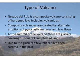
Nevado del Ruiz

        8A
     2/27/12
   Nicolas Hunt
Location
•   Ruiz is located in Calderas/Tolima, Columbia
•   In the Cordillera Central, Andes Range
•   Nevado del Ruiz lies within the Pacific Ring of Fire (convergent boundary)
•   The composition of the magma has a high viscosity and silica content
•   Like many other Andrean volcanoes, Nevado del Ruiz is a composite or
    stratovolcano
•   The summit of the volcano has steep slopes inclining from 20 to 30 degrees
•   The summit is covered by glaciers, in fact Nevado means “snow covered”
•   In the past when this volcano erupts it sends pyroclastic material out and creates a
    lahar most of the time, (a possible reason for the amount of glacier at the summit
    to decrease over time)
•   The capital of Columbia: Bagota is relatively close to Ruiz
•   Bagota has a population of 7,155,052
Location Diagrams


                    On the left
                    is all the
                    volcanoes
                    in Cloumbia
Type of Volcano
• Nevado del Ruiz is a composite volcano consisting
  of hardened lava including volcanic ash
• Composite volcanoes are created by alternate
  eruptions of pyroclastic material and lava flows
• At the summit of the volcano there are glaciers
  covering 10 square kilometers of land
• Due to the glaciers a few lahars have been
  created in the past
Self Created Image of Volcano
• Diagram of Nevado
                 By Nic   Diagram of
                          Nevado del Ruiz,
                          composite
                          volcano
                          (Scanned)
Impact
• The benefits of the volcano include tourist
  destination, provides a beautiful aspect to the
  land, and it is home to the mountain tapir and
  spectacled, both of which are ‘threatened’
• Some major dangers include another lahar,
  pyroclastic material causing physical damage
  to buildings, and the possibility of lowering
  temperatures in a violent eruption
Impact Pictures


1985 lahar
                  New land forming from magma
Monitoring the Volcano
• What is being used to monitor the volcano
  cannot be found
• However a few methods that could be used to
  monitor Ruiz would be a tiltmeter: to measure
  the slope of the cone, or a seismograph
  measuring the earthquakes created by volcanoes
• The steeper the measure of the slope the more
  likely there is to be an eruption
• The more intense and the higher number of
  earthquakes the more likely there is to be an
  eruption
Monitoring Method Pictures

                             Illustration of tilt and GPS
                             methods (below)


Experts taking gas samples
(above)
Eruptive History
•   The first eruptions of Nevado del Ruiz occurred about 1.8 million years ago. Three
    primary eruption periods in the history of the volcano have been identified:
    ancestral, older and present. During the ancestral period between one million to
    two million years ago, a complex of large stratovolcanoes was created. Between
    1.0 million and 0.8 million years ago, they partially collapsed, forming large (5–
    10 km wide) calderas. During the older period, which lasted from 0.8 million to 0.2
    million years ago, a new complex of large stratovolcanoes developed (including
    Older Ruiz, Tolima, Quindio, and Santa Isabel). Once again explosive summit
    calderas formed from 0.2 million to 0.15 million years ago.
•   On the morning of March 12, 1595, Nevado del Ruiz erupted. The volcano erupted
    pyroclastic material including lapilli and pumice bombs. Additionally, the eruption
    created a lahar was created killing more than 600 people
•   The worst recorded quake as far as casualties was at Amero on November 13, 1985
    killing 23,000 civilians and more than 10,000 animals
•   The most recent eruption was in 2008, it was a minor one
Nevado del Ruiz Eruption Pictures
Bibliography
Pics:
• http://www.google.com/search?client=safari&rls=en&q=ruiz+volca
   no&oe=UTF-8&um=1&ie=UTF-
   8&hl=en&tbm=isch&source=og&sa=N&tab=wi&ei=FTJMT634LMW
   RiQLEqcCTDw&biw=1353&bih=967&sei=FzJMT43TDcibiAL1o_nJDw
• http://www.google.com/search?client=safari&rls=en&q=nevado+d
   el+ruiz&ie=UTF-8&oe=UTF-8
Info:
• http://en.wikipedia.org/wiki/Nevado_del_Ruiz
• http://www.geology.sdsu.edu/how_volcanoes_work/Nevado.html
• http://vulcan.wr.usgs.gov/Volcanoes/Colombia/Ruiz/description_er
   uption_lahar_1985.html
• http://www.ngdc.noaa.gov/hazard/stratoguide/nevadofact.html

Ruiz volcano

  • 1.
    Nevado del Ruiz 8A 2/27/12 Nicolas Hunt
  • 2.
    Location • Ruiz is located in Calderas/Tolima, Columbia • In the Cordillera Central, Andes Range • Nevado del Ruiz lies within the Pacific Ring of Fire (convergent boundary) • The composition of the magma has a high viscosity and silica content • Like many other Andrean volcanoes, Nevado del Ruiz is a composite or stratovolcano • The summit of the volcano has steep slopes inclining from 20 to 30 degrees • The summit is covered by glaciers, in fact Nevado means “snow covered” • In the past when this volcano erupts it sends pyroclastic material out and creates a lahar most of the time, (a possible reason for the amount of glacier at the summit to decrease over time) • The capital of Columbia: Bagota is relatively close to Ruiz • Bagota has a population of 7,155,052
  • 3.
    Location Diagrams On the left is all the volcanoes in Cloumbia
  • 4.
    Type of Volcano •Nevado del Ruiz is a composite volcano consisting of hardened lava including volcanic ash • Composite volcanoes are created by alternate eruptions of pyroclastic material and lava flows • At the summit of the volcano there are glaciers covering 10 square kilometers of land • Due to the glaciers a few lahars have been created in the past
  • 5.
    Self Created Imageof Volcano • Diagram of Nevado By Nic Diagram of Nevado del Ruiz, composite volcano (Scanned)
  • 6.
    Impact • The benefitsof the volcano include tourist destination, provides a beautiful aspect to the land, and it is home to the mountain tapir and spectacled, both of which are ‘threatened’ • Some major dangers include another lahar, pyroclastic material causing physical damage to buildings, and the possibility of lowering temperatures in a violent eruption
  • 7.
    Impact Pictures 1985 lahar New land forming from magma
  • 8.
    Monitoring the Volcano •What is being used to monitor the volcano cannot be found • However a few methods that could be used to monitor Ruiz would be a tiltmeter: to measure the slope of the cone, or a seismograph measuring the earthquakes created by volcanoes • The steeper the measure of the slope the more likely there is to be an eruption • The more intense and the higher number of earthquakes the more likely there is to be an eruption
  • 9.
    Monitoring Method Pictures Illustration of tilt and GPS methods (below) Experts taking gas samples (above)
  • 10.
    Eruptive History • The first eruptions of Nevado del Ruiz occurred about 1.8 million years ago. Three primary eruption periods in the history of the volcano have been identified: ancestral, older and present. During the ancestral period between one million to two million years ago, a complex of large stratovolcanoes was created. Between 1.0 million and 0.8 million years ago, they partially collapsed, forming large (5– 10 km wide) calderas. During the older period, which lasted from 0.8 million to 0.2 million years ago, a new complex of large stratovolcanoes developed (including Older Ruiz, Tolima, Quindio, and Santa Isabel). Once again explosive summit calderas formed from 0.2 million to 0.15 million years ago. • On the morning of March 12, 1595, Nevado del Ruiz erupted. The volcano erupted pyroclastic material including lapilli and pumice bombs. Additionally, the eruption created a lahar was created killing more than 600 people • The worst recorded quake as far as casualties was at Amero on November 13, 1985 killing 23,000 civilians and more than 10,000 animals • The most recent eruption was in 2008, it was a minor one
  • 11.
    Nevado del RuizEruption Pictures
  • 12.
    Bibliography Pics: • http://www.google.com/search?client=safari&rls=en&q=ruiz+volca no&oe=UTF-8&um=1&ie=UTF- 8&hl=en&tbm=isch&source=og&sa=N&tab=wi&ei=FTJMT634LMW RiQLEqcCTDw&biw=1353&bih=967&sei=FzJMT43TDcibiAL1o_nJDw • http://www.google.com/search?client=safari&rls=en&q=nevado+d el+ruiz&ie=UTF-8&oe=UTF-8 Info: • http://en.wikipedia.org/wiki/Nevado_del_Ruiz • http://www.geology.sdsu.edu/how_volcanoes_work/Nevado.html • http://vulcan.wr.usgs.gov/Volcanoes/Colombia/Ruiz/description_er uption_lahar_1985.html • http://www.ngdc.noaa.gov/hazard/stratoguide/nevadofact.html