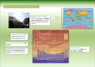
Eva de Heras Sánchez 3ºB
 Popularmente llamada Río.
                    Capital del Estado de Río de Janeiro al Sureste de Brasil, América del Sur.
                    Ubicación: 22°54′00″S 43°13′59″O
                    Conocida mundialmente como “La Ciudad Maravillosa”.
                    Segunda ciudad mas poblada de Brasil (aprox. 6’5 millones de habs.) y primer destino
                      turístico de América Latina.
                    Uno de los principales centros económicos, de recursos culturales y financieros del país.
                    Conocida internacionalmente por sus iconos culturales y paisajes.
                    Atraerá la atención mediática de todo el planeta con importantes acontecimientos:
                      Jornada Mundial de la Juventud 2013, la Copa Mundial de fútbol de 2014 y los Juegos
                      Olímpicos de 2016.


                              Río de Janeiro


Escudo   Bandera
1º Temperatures and precipitations: look at the average temperature

       Hot climate: <20ºC
       Temperate climate: 0º - 20ºC
       Cold climate: >0ºC
   -    Hot climate: look at the total amount of precipitations
         Equatorial: < 2000mm and it rains all over the year.
         Tropical: abundant precipitations and one dry season.
         Desert: little precipitations all over the year, > 250mm
   -     Temperate climate: look at the temperature range and the distribution of precipitations
         Mediterranean: hot summers and little precipitations.
         Continental: hot and rainy summers and cold winters.
         Oceanic: limited temperature variation temperature range and abundant precipitations all over the year,< 1000mm.
   -     Cold climate: look at the lowest and highest temperatures and the precipitation patterns
         Polar: extremely cold all over the year and little precipitations.
         High mountain: very cold in winter, cool in the summer and slightly rainy.

2º Hemisphere

    Northern hemisphere: temperatures rise from June to September. The temperatures line is convex.
    Southern hemisphere: temperatures rise from December to March. The temperatures line is concave.

3º Vegetation and wildlife

       Hot climate zones:
   -    Jungle: equatorial climate, exuberant vegetation, abundant precipitations and indigenous peoples (hunting and gathering).
   -    Savannah: tropical climate, tall grasses, riparian forests and people (livestock and agriculture).
   -    Desert: desert climate, (almost no vegetation) bushes, scrublands, oases and nomadic herdsmen (grazing).
       Temperate climate zones: there are three types of landscapes: oceanic, Mediterranean and continental.
       Cold climate zones: bushes, grasslands, tundra, fauna is made up of birds, (sparsely populated) Eskimos (hunt and fish) and Sami people
        (raise reindeer).
Rio has a tropical savannah          Climatic
                                     climate, according to the Köppen
                                                                           zones
                                     climate classification: one of the
                                     most used climate classification
                                     systems.


        Temperature range= 10ºC
        Highest temperature: 30 ºC
        Lowest temperature: 20 ºC


Average temperature= 25 ºC = Hot
climate

                                                                                     Total amount of
Temperatures rise from December to                                                   precipitations: 972mm and 1
March and the temperatures line is                                                   dry season = Tropical
concave, = Southern hemisphere.
Playa de Ipanema   Sambódromo


 Playa Copacabana


Playa de Leblon
Pão de Açúcar
Estadio de Maracaná   Corcovado, Cristo Redentor
Biblioteca Nacional   Parque Nacional de la Tijuca
o   http://que-visitar-en-rio-de-janeiro.mundoviajero.net/
o   http://es.wikipedia.org/wiki/R%C3%ADo_de_Janeiro
o   http://www.guiarte.com/rio-de-janeiro/que-ver.html
o   http://vicentecamarasa.wordpress.com/2009/11/08/como-se-comenta-un-climograma-y-ejercicios-para-practicar/
o   http://www.slideshare.net/isaacbuzo/comentario-de-un-climograma
o   http://es.scribd.com/doc/51266358/INTERPRETACION-DE-CLIMOGRAMAS
o   http://www.slideshare.net/Gemae/how-to-analyze-a-climograph
o   Google imágenes

Rio de Janeiro

  • 1.
    Eva de HerasSánchez 3ºB
  • 2.
     Popularmente llamadaRío.  Capital del Estado de Río de Janeiro al Sureste de Brasil, América del Sur.  Ubicación: 22°54′00″S 43°13′59″O  Conocida mundialmente como “La Ciudad Maravillosa”.  Segunda ciudad mas poblada de Brasil (aprox. 6’5 millones de habs.) y primer destino turístico de América Latina.  Uno de los principales centros económicos, de recursos culturales y financieros del país.  Conocida internacionalmente por sus iconos culturales y paisajes.  Atraerá la atención mediática de todo el planeta con importantes acontecimientos: Jornada Mundial de la Juventud 2013, la Copa Mundial de fútbol de 2014 y los Juegos Olímpicos de 2016. Río de Janeiro Escudo Bandera
  • 3.
    1º Temperatures andprecipitations: look at the average temperature  Hot climate: <20ºC  Temperate climate: 0º - 20ºC  Cold climate: >0ºC - Hot climate: look at the total amount of precipitations  Equatorial: < 2000mm and it rains all over the year.  Tropical: abundant precipitations and one dry season.  Desert: little precipitations all over the year, > 250mm - Temperate climate: look at the temperature range and the distribution of precipitations  Mediterranean: hot summers and little precipitations.  Continental: hot and rainy summers and cold winters.  Oceanic: limited temperature variation temperature range and abundant precipitations all over the year,< 1000mm. - Cold climate: look at the lowest and highest temperatures and the precipitation patterns  Polar: extremely cold all over the year and little precipitations.  High mountain: very cold in winter, cool in the summer and slightly rainy. 2º Hemisphere  Northern hemisphere: temperatures rise from June to September. The temperatures line is convex.  Southern hemisphere: temperatures rise from December to March. The temperatures line is concave. 3º Vegetation and wildlife  Hot climate zones: - Jungle: equatorial climate, exuberant vegetation, abundant precipitations and indigenous peoples (hunting and gathering). - Savannah: tropical climate, tall grasses, riparian forests and people (livestock and agriculture). - Desert: desert climate, (almost no vegetation) bushes, scrublands, oases and nomadic herdsmen (grazing).  Temperate climate zones: there are three types of landscapes: oceanic, Mediterranean and continental.  Cold climate zones: bushes, grasslands, tundra, fauna is made up of birds, (sparsely populated) Eskimos (hunt and fish) and Sami people (raise reindeer).
  • 4.
    Rio has atropical savannah Climatic climate, according to the Köppen zones climate classification: one of the most used climate classification systems. Temperature range= 10ºC Highest temperature: 30 ºC Lowest temperature: 20 ºC Average temperature= 25 ºC = Hot climate Total amount of Temperatures rise from December to precipitations: 972mm and 1 March and the temperatures line is dry season = Tropical concave, = Southern hemisphere.
  • 5.
    Playa de Ipanema Sambódromo Playa Copacabana Playa de Leblon
  • 6.
  • 7.
    Estadio de Maracaná Corcovado, Cristo Redentor
  • 8.
    Biblioteca Nacional Parque Nacional de la Tijuca
  • 9.
    o http://que-visitar-en-rio-de-janeiro.mundoviajero.net/ o http://es.wikipedia.org/wiki/R%C3%ADo_de_Janeiro o http://www.guiarte.com/rio-de-janeiro/que-ver.html o http://vicentecamarasa.wordpress.com/2009/11/08/como-se-comenta-un-climograma-y-ejercicios-para-practicar/ o http://www.slideshare.net/isaacbuzo/comentario-de-un-climograma o http://es.scribd.com/doc/51266358/INTERPRETACION-DE-CLIMOGRAMAS o http://www.slideshare.net/Gemae/how-to-analyze-a-climograph o Google imágenes