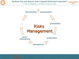
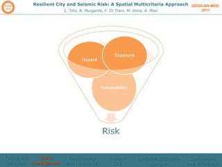
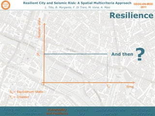
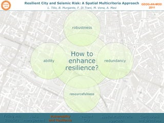
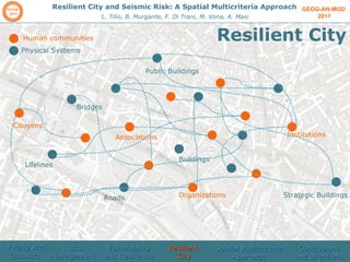
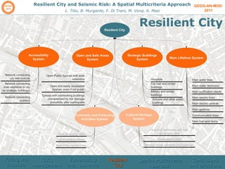
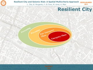
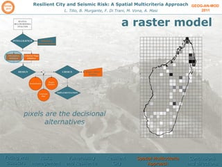
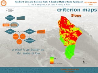
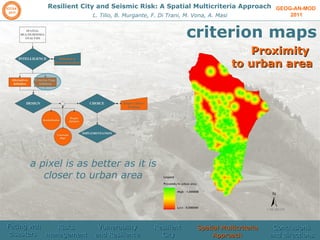
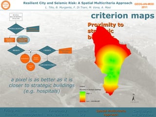
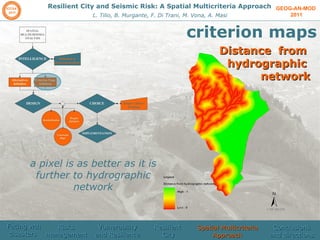
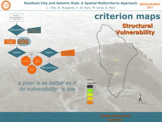
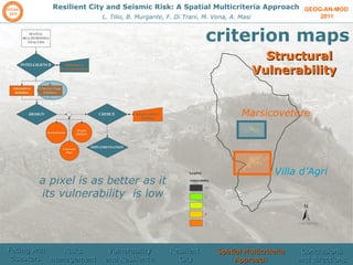
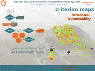
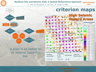
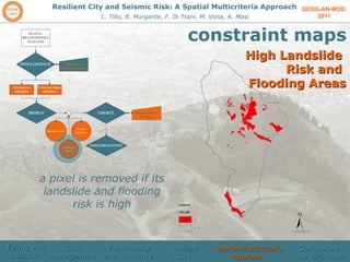
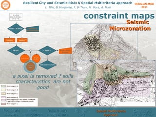
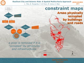
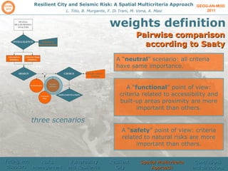
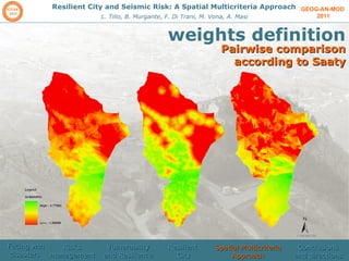
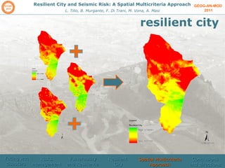
The document discusses using a spatial multicriteria approach to identify resilient cities and assess seismic risk, presenting a case study of Marsicovetere, Italy. Criteria maps and constraint maps were developed on topics like accessibility, slope, vulnerability, and hazards. These were combined to create an overall resilience assessment and identify better locations for future development.
Resilient city and seismic risk: a spatial multicriteria approachBeniamino Murgante
Resilient city and seismic risk: a spatial multicriteria approach
Lucia Tilio, Beniamino Murgante, Francesco Di Trani, Marco Vona, Angelo Masi - University of Basilicata
Craig Applegath of Cohos Evamy presents on the need for resilient cities in the face of increasingly volatile social and environmental changes.
Presented at the 5th annual Green Building Festival in Toronto, Canada, 2009.
Shocks and stresses are growing in frequency, impact and scale, with the ability to ripple across systems
and geographies. But cities are largely unprepared to respond, withstand, and rebound when disaster
strikes. The greatest burden of these increasing shocks, such as the impacts of climate change or public
health threats, often falls on poor and vulnerable people who have limited resources to cope with disaster
and who take longer to recover from it, disrupting livelihoods and increasing inequality.
The City Resilience Framework provides a lens through which the complexity of cities and the drivers that contribute to a city’s resilience can be understood. The 12 capacities in the 100RC City Resilience Framework collectively determine its ability a city’s resilience to a wide range of shocks and stresses.
Craig Applegath delivered the keynote address at the Resilient Communities in North America workshop of the CEC's Joint Public Advisory Committee in New Orleans on July 9, 2012. Find out more at http://www.cec.org/Council2012
Craig Applegath, a Principal with DIALOG, is an accomplished architect and urban designer. Since earning a Master of Architecture in Urban Design from Harvard University, Mr. Applegath has garnered a reputation for successfully leading complex institutional planning and design projects, advocating environmentally integrated design and urban resilience.
In addition to his project and practice responsibilities, Mr. Applegath is a sought-after lecturer and writer active within his industry and the community-at-large. He was named a Fellow of the Royal Architectural Institute of Canada and contributes to numerous organizations, including the Toronto WeatherWise Partnership, the Sandford Fleming Forum at the University of Toronto and the High-level Advisory Board convened by the European Commission. Mr. Applegath is currently working on a book, "Heroic Cities: How Cities Will Save Our Planet."
Field observations on building disaster resilient communities - hemkerRehne Gibb Larena
The session intends to present observations from various disaster-affected areas in different countries in terms of designing and actual building of disaster-resilient infrastructure as reference for the Philippines lie.
Enabling City Resilience through Building PerformanceEntuitive
How will your client’s business rebound after it’s struck by an unexpected and potentially catastrophic event? Entuitive’s Barry Charnish and Matthew Smith explored the subject of designing for performance to support resilience in both organizations and communities at the Sanford Fleming Forum organized by The Centre for Resilience of Critical Infrastructure. Dig into designing for seismic, climate, fire, and targeted events in their presentation.
Connectivity in action/form. A model for evaluating spatial impacts of wirele...Selena Savic
This presentation introduces a weak argument that architecturality of wireless communication infrastructure results from the fact that wireless signals, like architecture, incorporate agency. By agency, we mean a capacity of a system to autonomously and adaptively regulates its relationship/goals within a certain environment.
The weakness off this argument resides mainly in the fact that agency is not the most perceived property of architecture - it is a contested feature and requires complicated argumentation. Nevertheless, it will be demonstrated how it is exactly here that we should build foundations for a model for evaluating spatial impacts of wireless communication.
Wireless communication signals partake in the production of urbanity as connectivity that is or not available to people and devices. Ultimately, they outline a binary spatial configuration: connected and disconnected places. In this respect, we regard waves as structural infrastructure. We examine the materiality of connectivity - a phenomenon beyond mere functioning connection – the form given to wirelessness through action.
Resilient City and Seismic Risk: A Spatial Multicriteria ApproachVijay Meena
Urban Resilience is the capacity of individuals, communities, institutions, businesses, and systems within a city to survive, adapt, and grow no matter what kinds of chronic stresses and acute shocks they experience.
IoT is changing the way cities are run till recently .With real data analysis IoT can make city more resilient and sustainable. We at Vogelkop Design helps to find solutions for sustainable ways and means to do so. Attached presentation would give you glimpse of how IoT is changing the scenario.
To know more about how we can help to incorporate IoT solutions for built spaces as well as city planning , please send your queries to vogelkopdesigns@gmail.com
Presentation by Mary W. Rowe of the New Orleans Institute to the Chief of Staff Retreat convened by the Mercatus Center, Philadelphia, February 21, 2009
A Framework for Resilient Design: Lessons and Examples from New Orleans and B...Eskew+Dumez+Ripple
How do you solve an equation with nothing but variables?
One of the many challenges facing the US Army Corps of Engineers is coastal damage caused by waves, wind and surge. Hurricanes have significantly increased the vulnerability of coastal areas to natural disasters. The Corps aims to reduce these coastal risks and “improve resilience to these hazards through an integrated approach that draws from the full array of coastal risk reduction measures.”
TEN Essentials for MAKING CITIES RESILIENTabhilash.panda
The 10 Essentials for Making Cities Resilient developed by UN and global expert agencies are critical and interdependent steps which local governments may take to make their city more disaster resilient.
The City Resilience Framework is a unique framework developed by Arup with support from the Rockefeller Foundation, based on extensive research in cities. It provides a lens to understand the complexity of cities and the drivers that contribute to their resilience. Looking at these drivers can help cities to assess the extent of their resilience, to identify critical areas of weakness, and to identify actions and programs to improve the city’s resilience.
I Laboratori di Urbanistica Partecipata a Potenza: sperimentazione di tecnich...Lucia Tilio
I Laboratori di Urbanistica Partecipata a Potenza: sperimentazione di tecniche e strumenti, presented with Viviana Lanza @INPUT 2010, Settembre 2010, Università degli Studi della Basilicata
Work by Lucia Tilio, Viviana Lanza, Piergiuseppe Pontrandolfi
Indirizzi per la pianificazione degli "spazi giovani": il caso studio del com...Lucia Tilio
Indirizzi per la pianificazione degli "spazi giovani": il caso studio del comune di Potenza, presented @Vivere e Camminare in città 2009, Brescia, Giugno 2009
Work by Lucia Tilio, Viviana Lanza, Piergiuseppe Pontrandolfi
Open source resources and web 2.0 potentialities for a new democratic approac...Lucia Tilio
Open source resources and web 2.0 potentialities for a new democratic approach in programming practices, presented @WSKS 2009, Chanià, Greece, September 2009
Work by Lucia Tilio, Viviana Lanza, Francesco Scorza, Beniamino Murgante
WebGIS 2.0: New approaches to democratic public involvement to programming pr...Lucia Tilio
WebGIS 2.0: New approaches to democratic public involvement to programming processes, presented @eGov2009, in DEXA Conference, Linz, Austria, 31 August - 4 September 2009
Work by Lucia Tilio, Viviana Lanza, Francesco Scorza, Beniamino Murgante
WebGIS 2.0: e-democracy per la programmazione economicaLucia Tilio
WebGIS 2.0: e-democracy per la programmazione economica, presented @Expo2015Camp, Palazzo delle Stelline, http://barcamp.org/Expo2015Camp, 25 June 2009, Milan, Italy.
Work by Lucia Tilio, Viviana Lanza, Francesco Scorza, Beniamino Murgante
Assessing macroseismic data reliability through Rough Set Theory: application...Lucia Tilio
Assessing macroseismic data reliability through Rough Set Theory: application on Vulture Area (Basilicata, Southern Italy), presented @KES IDT 2010, Baltimore, 28-30 July 2010.
Work by Fabrizio Gizzi, Nicola Masini, Maria Danese, Cinzia Zotta, Maria Rosaria Potenza, Beniamino Murgante, Lucia Tilio
Premium MEAN Stack Development Solutions for Modern BusinessesSynapseIndia
Stay ahead of the curve with our premium MEAN Stack Development Solutions. Our expert developers utilize MongoDB, Express.js, AngularJS, and Node.js to create modern and responsive web applications. Trust us for cutting-edge solutions that drive your business growth and success.
Know more: https://www.synapseindia.com/technology/mean-stack-development-company.html
An introduction to the cryptocurrency investment platform Binance Savings.Any kyc Account
Learn how to use Binance Savings to expand your bitcoin holdings. Discover how to maximize your earnings on one of the most reliable cryptocurrency exchange platforms, as well as how to earn interest on your cryptocurrency holdings and the various savings choices available.
In the Adani-Hindenburg case, what is SEBI investigating.pptxAdani case
Adani SEBI investigation revealed that the latter had sought information from five foreign jurisdictions concerning the holdings of the firm’s foreign portfolio investors (FPIs) in relation to the alleged violations of the MPS Regulations. Nevertheless, the economic interest of the twelve FPIs based in tax haven jurisdictions still needs to be determined. The Adani Group firms classed these FPIs as public shareholders. According to Hindenburg, FPIs were used to get around regulatory standards.
Personal Brand Statement:
As an Army veteran dedicated to lifelong learning, I bring a disciplined, strategic mindset to my pursuits. I am constantly expanding my knowledge to innovate and lead effectively. My journey is driven by a commitment to excellence, and to make a meaningful impact in the world.
LA HUG - Video Testimonials with Chynna Morgan - June 2024Lital Barkan
Have you ever heard that user-generated content or video testimonials can take your brand to the next level? We will explore how you can effectively use video testimonials to leverage and boost your sales, content strategy, and increase your CRM data.🤯
We will dig deeper into:
1. How to capture video testimonials that convert from your audience 🎥
2. How to leverage your testimonials to boost your sales 💲
3. How you can capture more CRM data to understand your audience better through video testimonials. 📊
[Note: This is a partial preview. To download this presentation, visit:
https://www.oeconsulting.com.sg/training-presentations]
Sustainability has become an increasingly critical topic as the world recognizes the need to protect our planet and its resources for future generations. Sustainability means meeting our current needs without compromising the ability of future generations to meet theirs. It involves long-term planning and consideration of the consequences of our actions. The goal is to create strategies that ensure the long-term viability of People, Planet, and Profit.
Leading companies such as Nike, Toyota, and Siemens are prioritizing sustainable innovation in their business models, setting an example for others to follow. In this Sustainability training presentation, you will learn key concepts, principles, and practices of sustainability applicable across industries. This training aims to create awareness and educate employees, senior executives, consultants, and other key stakeholders, including investors, policymakers, and supply chain partners, on the importance and implementation of sustainability.
LEARNING OBJECTIVES
1. Develop a comprehensive understanding of the fundamental principles and concepts that form the foundation of sustainability within corporate environments.
2. Explore the sustainability implementation model, focusing on effective measures and reporting strategies to track and communicate sustainability efforts.
3. Identify and define best practices and critical success factors essential for achieving sustainability goals within organizations.
CONTENTS
1. Introduction and Key Concepts of Sustainability
2. Principles and Practices of Sustainability
3. Measures and Reporting in Sustainability
4. Sustainability Implementation & Best Practices
To download the complete presentation, visit: https://www.oeconsulting.com.sg/training-presentations
Event Report - SAP Sapphire 2024 Orlando - lots of innovation and old challengesHolger Mueller
Holger Mueller of Constellation Research shares his key takeaways from SAP's Sapphire confernece, held in Orlando, June 3rd till 5th 2024, in the Orange Convention Center.
Business Valuation Principles for EntrepreneursBen Wann
This insightful presentation is designed to equip entrepreneurs with the essential knowledge and tools needed to accurately value their businesses. Understanding business valuation is crucial for making informed decisions, whether you're seeking investment, planning to sell, or simply want to gauge your company's worth.
Improving profitability for small businessBen Wann
In this comprehensive presentation, we will explore strategies and practical tips for enhancing profitability in small businesses. Tailored to meet the unique challenges faced by small enterprises, this session covers various aspects that directly impact the bottom line. Attendees will learn how to optimize operational efficiency, manage expenses, and increase revenue through innovative marketing and customer engagement techniques.
Kseniya Leshchenko: Shared development support service model as the way to ma...Lviv Startup Club
Kseniya Leshchenko: Shared development support service model as the way to make small projects with small budgets profitable for the company (UA)
Kyiv PMDay 2024 Summer
Website – www.pmday.org
Youtube – https://www.youtube.com/startuplviv
FB – https://www.facebook.com/pmdayconference
B2B payments are rapidly changing. Find out the 5 key questions you need to be asking yourself to be sure you are mastering B2B payments today. Learn more at www.BlueSnap.com.
1. GEOGRAPHICAL ANALYSIS, URBAN MODELING, SPATIAL STATISTICS 2011 Resilient City and Seismic Risk: A Spatial Multicriteria Approach Lucia Tilio, Beniamino Murgante, Francesco Di Trani, Marco Vona, Angelo Masi ICCSA 2011
2. GEOG-AN-MOD 2011 Resilient City and Seismic Risk: A Spatial Multicriteria Approach L. Tilio, B. Murgante, F. Di Trani, M. Vona, A. Masi summary Facing with disasters Risks Management Vulnerability and Resilience A spatial Multicriteria approach Conclusion and directions Resilient City
3. GEOG-AN-MOD 2011 Resilient City and Seismic Risk: A Spatial Multicriteria Approach L. Tilio, B. Murgante, F. Di Trani, M. Vona, A. Masi Facing wth disasters Risks management Vulnerability and Resilience Resilient City Spatial Multicriteria Approach Conclusions and directions
4. GEOG-AN-MOD 2011 Resilient City and Seismic Risk: A Spatial Multicriteria Approach L. Tilio, B. Murgante, F. Di Trani, M. Vona, A. Masi Messina, 28 december 1908 S. Giuliano, 31 october 2002 L’Aquila, 6 April 2009 Potenza, 23 november 1980 Facing wth disasters Risks management Vulnerability and Resilience Resilient City Spatial Multicriteria Approach Conclusions and directions
5. GEOG-AN-MOD 2011 Resilient City and Seismic Risk: A Spatial Multicriteria Approach L. Tilio, B. Murgante, F. Di Trani, M. Vona, A. Masi Need to be SuperHeroes??? Facing wth disasters Risks management Vulnerability and Resilience Resilient City Spatial Multicriteria Approach Conclusions and directions
6. GEOG-AN-MOD 2011 Resilient City and Seismic Risk: A Spatial Multicriteria Approach L. Tilio, B. Murgante, F. Di Trani, M. Vona, A. Masi No!need to be normal Facing wth disasters Risks management Vulnerability and Resilience Resilient City Spatial Multicriteria Approach Conclusions and directions
7. GEOG-AN-MOD 2011 Resilient City and Seismic Risk: A Spatial Multicriteria Approach L. Tilio, B. Murgante, F. Di Trani, M. Vona, A. Masi … and to act! scientists Decision makers Common people Facing wth disasters Risks management Vulnerability and Resilience Resilient City Spatial Multicriteria Approach Conclusions and directions
8. GEOG-AN-MOD 2011 Resilient City and Seismic Risk: A Spatial Multicriteria Approach L. Tilio, B. Murgante, F. Di Trani, M. Vona, A. Masi Risks Management Facing wth disasters Risks management Vulnerability and Resilience Resilient City Spatial Multicriteria Approach Conclusions and directions
9. GEOG-AN-MOD 2011 Resilient City and Seismic Risk: A Spatial Multicriteria Approach L. Tilio, B. Murgante, F. Di Trani, M. Vona, A. Masi Facing wth disasters Risks management Vulnerability and Resilience Resilient City Spatial Multicriteria Approach Conclusions and directions
10. GEOG-AN-MOD 2011 Resilient City and Seismic Risk: A Spatial Multicriteria Approach L. Tilio, B. Murgante, F. Di Trani, M. Vona, A. Masi Hazard Global map, Giardini, Gryintal, Shedlock, Zhang, 1999 Facing wth disasters Risks management Vulnerability and Resilience Resilient City Spatial Multicriteria Approach Conclusions and directions
11. GEOG-AN-MOD 2011 Resilient City and Seismic Risk: A Spatial Multicriteria Approach L. Tilio, B. Murgante, F. Di Trani, M. Vona, A. Masi Exposure Population density (people per km2) by country, 2006 Miguel Contreras, lala land, 2007 Facing wth disasters Risks management Vulnerability and Resilience Resilient City Spatial Multicriteria Approach Conclusions and directions
12. GEOG-AN-MOD 2011 Resilient City and Seismic Risk: A Spatial Multicriteria Approach L. Tilio, B. Murgante, F. Di Trani, M. Vona, A. Masi Vulnerability Facing wth disasters Risks management Vulnerability and Resilience Resilient City Spatial Multicriteria Approach Conclusions and directions
13. GEOG-AN-MOD 2011 Resilient City and Seismic Risk: A Spatial Multicriteria Approach L. Tilio, B. Murgante, F. Di Trani, M. Vona, A. Masi Vulnerability Structural vulnerability Facing wth disasters Risks management Vulnerability and Resilience Resilient City Spatial Multicriteria Approach Conclusions and directions
14. GEOG-AN-MOD 2011 Resilient City and Seismic Risk: A Spatial Multicriteria Approach L. Tilio, B. Murgante, F. Di Trani, M. Vona, A. Masi Vulnerability Structural vulnerability Urban vulnerability Facing wth disasters Risks management Vulnerability and Resilience Resilient City Spatial Multicriteria Approach Conclusions and directions
15. GEOG-AN-MOD 2011 Resilient City and Seismic Risk: A Spatial Multicriteria Approach L. Tilio, B. Murgante, F. Di Trani, M. Vona, A. Masi Facing wth disasters Risks management Vulnerability and Resilience Resilient City Spatial Multicriteria Approach Conclusions and directions
16. GEOG-AN-MOD 2011 Resilient City and Seismic Risk: A Spatial Multicriteria Approach L. Tilio, B. Murgante, F. Di Trani, M. Vona, A. Masi Resilience time System state S e T d S e = Equilibrium State T d = Disaster And then ? Facing wth disasters Risks management Vulnerability and Resilience Resilient City Spatial Multicriteria Approach Conclusions and directions
17. GEOG-AN-MOD 2011 Resilient City and Seismic Risk: A Spatial Multicriteria Approach L. Tilio, B. Murgante, F. Di Trani, M. Vona, A. Masi Resilience Planned preparation Spontaneous adjustments Facing wth disasters Risks management Vulnerability and Resilience Resilient City Spatial Multicriteria Approach Conclusions and directions
18. GEOG-AN-MOD 2011 Resilient City and Seismic Risk: A Spatial Multicriteria Approach L. Tilio, B. Murgante, F. Di Trani, M. Vona, A. Masi Resilience Social aspects Facing wth disasters Risks management Vulnerability and Resilience Resilient City Spatial Multicriteria Approach Conclusions and directions
19. GEOG-AN-MOD 2011 Resilient City and Seismic Risk: A Spatial Multicriteria Approach L. Tilio, B. Murgante, F. Di Trani, M. Vona, A. Masi Resilience Facing wth disasters Risks management Vulnerability and Resilience Resilient City Spatial Multicriteria Approach Conclusions and directions Resilience is capacity of a system, community or society potentially exposed to hazards to adapt by resisting or changing in order to reach and maintain an acceptable level of functioning and structure and is determined by the degree to which the social system is capable of organizing itself to increase its capacity of learning from past disasters for better future protection and to improve risk reduction measures.
20. GEOG-AN-MOD 2011 Resilient City and Seismic Risk: A Spatial Multicriteria Approach L. Tilio, B. Murgante, F. Di Trani, M. Vona, A. Masi Facing wth disasters Risks management Vulnerability and Resilience Resilient City Spatial Multicriteria Approach Conclusions and directions
21. GEOG-AN-MOD 2011 Resilient City and Seismic Risk: A Spatial Multicriteria Approach L. Tilio, B. Murgante, F. Di Trani, M. Vona, A. Masi Resilient City Institutions Associations Organizations Citoyens Public Buildings Roads Lifelines Strategic Buildings Bridges Buildings Human communities Physical Systems Facing wth disasters Risks management Vulnerability and Resilience Resilient City Spatial Multicriteria Approach Conclusions and directions
22. GEOG-AN-MOD 2011 Resilient City and Seismic Risk: A Spatial Multicriteria Approach L. Tilio, B. Murgante, F. Di Trani, M. Vona, A. Masi Resilient City Facing wth disasters Risks management Vulnerability and Resilience Resilient City Spatial Multicriteria Approach Conclusions and directions
23. GEOG-AN-MOD 2011 Resilient City and Seismic Risk: A Spatial Multicriteria Approach L. Tilio, B. Murgante, F. Di Trani, M. Vona, A. Masi Resilient City Forecasting Post Emergency Phase Emergency Phase Prevention Facing wth disasters Risks management Vulnerability and Resilience Resilient City Spatial Multicriteria Approach Conclusions and directions
24. GEOG-AN-MOD 2011 Resilient City and Seismic Risk: A Spatial Multicriteria Approach L. Tilio, B. Murgante, F. Di Trani, M. Vona, A. Masi Resilient City: how to identify? In Marsicovetere, Basilicata Region, South of Italy Facing wth disasters Risks management Vulnerability and Resilience Resilient City Spatial Multicriteria Approach Conclusions and directions
25.
26. GEOG-AN-MOD 2011 Resilient City and Seismic Risk: A Spatial Multicriteria Approach L. Tilio, B. Murgante, F. Di Trani, M. Vona, A. Masi spatial multicriteria model Facing wth disasters Risks management Vulnerability and Resilience Resilient City Spatial Multicriteria Approach Conclusions and directions
27. GEOG-AN-MOD 2011 Resilient City and Seismic Risk: A Spatial Multicriteria Approach L. Tilio, B. Murgante, F. Di Trani, M. Vona, A. Masi a raster model pixels are the decisional alternatives Facing wth disasters Risks management Vulnerability and Resilience Resilient City Spatial Multicriteria Approach Conclusions and directions
28. GEOG-AN-MOD 2011 Resilient City and Seismic Risk: A Spatial Multicriteria Approach L. Tilio, B. Murgante, F. Di Trani, M. Vona, A. Masi criterion maps Accessibility a pixel is as better as it is closer to road network Facing wth disasters Risks management Vulnerability and Resilience Resilient City Spatial Multicriteria Approach Conclusions and directions
29. GEOG-AN-MOD 2011 Resilient City and Seismic Risk: A Spatial Multicriteria Approach L. Tilio, B. Murgante, F. Di Trani, M. Vona, A. Masi criterion maps Slope a pixel is as better as its slope is low Facing wth disasters Risks management Vulnerability and Resilience Resilient City Spatial Multicriteria Approach Conclusions and directions
30. GEOG-AN-MOD 2011 Resilient City and Seismic Risk: A Spatial Multicriteria Approach L. Tilio, B. Murgante, F. Di Trani, M. Vona, A. Masi criterion maps Proximity to urban area a pixel is as better as it is closer to urban area Facing wth disasters Risks management Vulnerability and Resilience Resilient City Spatial Multicriteria Approach Conclusions and directions
31. GEOG-AN-MOD 2011 Resilient City and Seismic Risk: A Spatial Multicriteria Approach L. Tilio, B. Murgante, F. Di Trani, M. Vona, A. Masi criterion maps Proximity to strategic buildings a pixel is as better as it is closer to strategic buildings (e.g. hospitals) Facing wth disasters Risks management Vulnerability and Resilience Resilient City Spatial Multicriteria Approach Conclusions and directions
32. GEOG-AN-MOD 2011 Resilient City and Seismic Risk: A Spatial Multicriteria Approach L. Tilio, B. Murgante, F. Di Trani, M. Vona, A. Masi criterion maps Distance from hydrographic network a pixel is as better as it is further to hydrographic network Facing wth disasters Risks management Vulnerability and Resilience Resilient City Spatial Multicriteria Approach Conclusions and directions
33. GEOG-AN-MOD 2011 Resilient City and Seismic Risk: A Spatial Multicriteria Approach L. Tilio, B. Murgante, F. Di Trani, M. Vona, A. Masi criterion maps a pixel is as better as it its vulnerability is low Structural Vulnerability Facing wth disasters Risks management Vulnerability and Resilience Resilient City Spatial Multicriteria Approach Conclusions and directions
34. GEOG-AN-MOD 2011 Resilient City and Seismic Risk: A Spatial Multicriteria Approach L. Tilio, B. Murgante, F. Di Trani, M. Vona, A. Masi criterion maps a pixel is as better as it its vulnerability is low Structural Vulnerability Marsicovetere Villa d’Agri Facing wth disasters Risks management Vulnerability and Resilience Resilient City Spatial Multicriteria Approach Conclusions and directions
35. GEOG-AN-MOD 2011 Resilient City and Seismic Risk: A Spatial Multicriteria Approach L. Tilio, B. Murgante, F. Di Trani, M. Vona, A. Masi criterion maps a pixel is as better as it its vulnerability is low Structural Vulnerability Facing wth disasters Risks management Vulnerability and Resilience Resilient City Spatial Multicriteria Approach Conclusions and directions
36. GEOG-AN-MOD 2011 Resilient City and Seismic Risk: A Spatial Multicriteria Approach L. Tilio, B. Murgante, F. Di Trani, M. Vona, A. Masi criterion maps a pixel is as better as its seismic hazard is low High Seismic Hazard Areas Facing wth disasters Risks management Vulnerability and Resilience Resilient City Spatial Multicriteria Approach Conclusions and directions
37. GEOG-AN-MOD 2011 Resilient City and Seismic Risk: A Spatial Multicriteria Approach L. Tilio, B. Murgante, F. Di Trani, M. Vona, A. Masi constraint maps High Landslide Risk and Flooding Areas a pixel is removed if its landslide and flooding risk is high Facing wth disasters Risks management Vulnerability and Resilience Resilient City Spatial Multicriteria Approach Conclusions and directions
38. GEOG-AN-MOD 2011 Resilient City and Seismic Risk: A Spatial Multicriteria Approach L. Tilio, B. Murgante, F. Di Trani, M. Vona, A. Masi constraint maps a pixel is removed if soils characteristics are not good Seismic Microzonation Facing wth disasters Risks management Vulnerability and Resilience Resilient City Spatial Multicriteria Approach Conclusions and directions
39. GEOG-AN-MOD 2011 Resilient City and Seismic Risk: A Spatial Multicriteria Approach L. Tilio, B. Murgante, F. Di Trani, M. Vona, A. Masi constraint maps a pixel is removed if it is “occupied” by structures and infrastructures Areas physically occupied by buildings and roads Facing wth disasters Risks management Vulnerability and Resilience Resilient City Spatial Multicriteria Approach Conclusions and directions
40. GEOG-AN-MOD 2011 Resilient City and Seismic Risk: A Spatial Multicriteria Approach L. Tilio, B. Murgante, F. Di Trani, M. Vona, A. Masi weights definition three scenarios Pairwise comparison according to Saaty A “ neutral ” scenario: all criteria have same importance. A “ functional ” point of view: criteria related to accessibility and built-up areas proximity are more important than others. A “ safety ” point of view: criteria related to natural risks are more important than others. Facing wth disasters Risks management Vulnerability and Resilience Resilient City Spatial Multicriteria Approach Conclusions and directions
41. GEOG-AN-MOD 2011 Resilient City and Seismic Risk: A Spatial Multicriteria Approach L. Tilio, B. Murgante, F. Di Trani, M. Vona, A. Masi weights definition Pairwise comparison according to Saaty Facing wth disasters Risks management Vulnerability and Resilience Resilient City Spatial Multicriteria Approach Conclusions and directions
42. GEOG-AN-MOD 2011 Resilient City and Seismic Risk: A Spatial Multicriteria Approach L. Tilio, B. Murgante, F. Di Trani, M. Vona, A. Masi resilient city Facing wth disasters Risks management Vulnerability and Resilience Resilient City Spatial Multicriteria Approach Conclusions and directions
43. GEOG-AN-MOD 2011 Resilient City and Seismic Risk: A Spatial Multicriteria Approach L. Tilio, B. Murgante, F. Di Trani, M. Vona, A. Masi conclusions A first approach to resilient city identification Some lack of information A map to communicate resilience The right scale? Another multicriteria model ? How to maximize resilience More criteria to diversify alternatives Facing wth disasters Risks management Vulnerability and Resilience Resilient City Spatial Multicriteria Approach Conclusions and directions
Editor's Notes
Pelling
Pelling
Pelling
Rispetto alle 4 fasi in sequenza della protezione civile io guardo qui non alla sequena temporale ma all’allargamento spaziale dellas resiliernt city
The system allows to visualize and query probabilistic seismic hazard maps of the Italian national territory, represented by several shaking parametrs on a regular grid spaced by 0.05°.The maps display two shaking parameters, PGA (horizontal peak ground acceleration) and Sa (spectral acceleration); the unit of measure is g , i.e. the gravity acceleration, corresponding to 9.8m/sec^2. Only for PGA values the associated disaggregation analysis is available. Maps in PGA were evaluated for different probabilities of exceedance in 50 years (9 probabilities, from 2% to 81%). For each evaluation it is available the distribution of the 50th percentile (median map, which is the reference map for every probability of exceedance) and the distribution of the 16th and 84th percentiles, which give the variability of each estimate. The details about the computation of these hazard estimates are available at the page describing deliverable D2 of this project ( http://esse1.mi.ingv.it/d2.html ) Also maps in Sa were calculated for the same probabilities of exceedance in 50 years (9 probabilities, from 2% to 81%) and for different periods (10 periods, from 0.1 to 2 seconds). Also in this case for each evaluation is available the distribution of the 50th percentile (median map, which is the reference map for every probability of exceedance) and the distribution of the 16th and 84th percentiles, which give the variability of each estimate. The details about the computation of these hazard estimates are available at the page describing deliverable D3 of this project ( http://esse1.mi.ingv.it/d3.html ) The user, in the area Map Selection can select the parameters of the required map, then pressing the Redraw map button will have the required map. For every single node of the reference grid, throught the instrument Graph on the grid point , it is possible to ask for the details of the visualized shaking parameter in graphical format, together with the tabular data. From the PGA map, for each node, the user will get the corresponding hazard curve (the PGA Vs different annual probabilities of exceedance); from the Sa map the user will get the UHS (Uniform Hazard Spectra) for different probabilities of exceedance. For every single node of the reference grid it is possible to ask for the details in graphical and tabular format of the disaggregation analysis of the associated PGA value, using the tool Disaggregation graph ; also the mean values of M, D, and ε (the mean magnitude, distance, epsilon values that mostly contribute to the hazard) will be returned. The details about the achievent of these analysis are available at the page describing deliverable D14 of this project ( http://esse1.mi.ingv.it/d14.html )