Download as PDF, PPTX


![67
Team Heavy Lift XII. Appendix
● Emil Lissauer, NYC Office of Citywide Event Coordination & Management
● Office of Emergency Management
Physical Infrastructure
● Army Corp of Engineers
● Malcolm Mclaren, Mclaren Engineering
● Jonathan Goldstick, Halcrow
● Don Jon Marine Co. (tentative)
Deliverable: Summary and analysis of interviews
Anticipated date of completion: Thursday, October 22, 2015
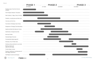
Task 2.2: Breakdown of service areas
● Map anticipated built development in New York City
● Determine factors for viable service areas across Manhattan
● Identify locations/zones that can (and cannot or should not) function as service areas
● Determine specific needs and limitations of each identified service area
● Conduct bike tour of the Manhattan waterfront to identify potential sites (Tentative Date: October
15)
Deliverable: Map delineating service areas
Anticipated date of completion: Thursday, October 22, 2015
[Feedback period: October 22 28]
Task 2.3: Development of site selection criteria
● Conduct second boat tour of Manhattan waterfront (date TBD)
Deliverable: Written analysis and maps
Anticipated date of completion: Monday, November 2, 2015
[Feedback period: November 2 6]
Task 2.4: Identification of potential project sites
● Identify all potential sites
● Determine and rank sites based upon feasibility
Deliverable: Visual and written description and analysis of each potential site
Anticipated date of completion: Thursday, November 12, 2015
[Feedback period: November 12 19]
PHASE III: DESIGN INTERVENTIONS + RECOMMENDATIONS
Task 3.1: Produce preliminary site specific design interventions for full time and part time sites that are
selected through the site identification process.
Deliverable: Drawing, classification and description of each design intervention
Anticipated date of completion: Thursday, December 3, 2015
[Feedback period: December 3 8]
Final Deliverable: Graphics and maps of selected locations in the form of a Presentation and
report to be delivered to NYCEDC, Office of Emergency Management, Department of City
Planning and the Mayor’s Office of Recovery and Resiliency.
Anticipated date of completion: December 2015, date TBD
3](https://image.slidesharecdn.com/443abb7d-c5a5-4a23-a6a0-b1cf20892fd8-160824180625/85/Report-71-320.jpg)
![68
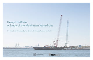
Heavy Lift/RoRo: A Study of the Manhattan Waterfront Dec, 2015
Appendix B. Terminology
1. Barge - A non-powered vessel with a flat bottom, typically
used for transport or a work platform, moved by a tugboat.
2. Bathymetric Survey: The measurement of water depths,
usually with sufficient detail to map the underwater terrain
contours.
3. Berth: The water area along the edge of a wharf or pier for
vessel mooring.
4. Bulkhead: A structure or partition built to retain or prevent
sliding of the land (FEMA, 2015).
5. Datum:
6. Diurnal Tide: A tide with one high and one low water in a
day.
7. Draft: Maximum depth of a vessel’s hull below the waterline.
8. Dredge - A barge with a crane, suction device or other
mechanism to lift mud off the bottom for the purpose of
increasing the water depth to allow passage of deeper draft
vessels (Doswell, 2012).
9. Fender: A device placed between a dock structure and a
vessel, used to absorb berthing impact energy and provide
a wearing surface for the vessel while moored to the
structure.
10. Gangway: A sloping ramp to provide access from a dock
structure to a vessel or floating dock from the shore.
11. Higher High Water (HHW): The higher of two high tides in
any given tidal day.
12. Mean High Water (MHW): The mean of all high water levels
(two per day for diurnal tides), observed over a 19 year tidal
epoch (Metonic cycle).
13. Mean Higher Water (MHHW): The mean of the highest daily
high water levels (one per day), observed over a 19 year
tidal epoch (Metonic cycle).
14. Mean Low Water (MLW): The mean of all low water levels
(two per day for diurnal tides), observed over a 19 year tidal
epoch (Metonic cycle).
15. Mean Lower Low Water (MLLW): The mean of lowest low
water levels (one per day), over a 19 year tidal epoch
(Metonic cycle).
16. PGC: This refers to power generation components used by
utility companies.
17. Pier: A deck supported on piles, extending into the water,
more or less perpendicular from the shoreline.
18. Pile: A pole, typically of timber, reinforced plastic, steel or
concrete, driven or otherwise set into the soil or rock to
resist applied vertical and/or horizontal loads.
19. Riprap: Slope erosion protection formed from stone or
concrete rubble, typically dumped and graded over the
surface of a prepared shoreline slope.
20. Self propelled modular transporter: A platform vehicle with
multiple axle lines are used for transporting massive objects
such as large bridge sections,[1]oil refining equipment,
motors and other objects that are too big or heavy for
trucks.
21. Slack Water: The state of a tidal current when its speed is
near zero, as when reversing direction
Data Source: Waterfront Terminology, Tighe & Bond
(from http://www.tighebond.com/includes/upload/assets/
waterfront%20terminology.pdf)](https://image.slidesharecdn.com/443abb7d-c5a5-4a23-a6a0-b1cf20892fd8-160824180625/85/Report-72-320.jpg)


This document provides background information on heavy lift operations in Manhattan. It defines heavy lift as cargo over 100 metric tons and notes that utility companies like ConEd regularly require waterfront access to transport heavy equipment. Two precedents for heavy lift sites in Manhattan are discussed: Pier 86, where ConEd currently operates; and the Cornell Tech campus on Roosevelt Island, where demolition waste and materials are barged to reduce truck traffic. The document also includes diagrams of standard heavy lift barge and cargo trailer equipment. The goal of this study is to identify additional suitable sites along Manhattan's waterfront to support heavy lift activities for utilities, construction, and emergencies.


