Download to read offline
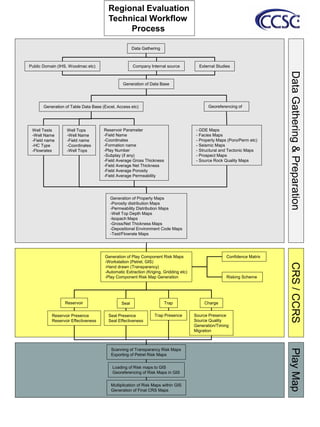

The document outlines a regional evaluation technical workflow process that involves: 1) Generating play component risk maps through various methods like workstations, hand drawing, and automatic extraction to assess risks related to reservoirs, seals, traps, and hydrocarbon generation and migration. 2) Scanning, exporting, and georeferencing the risk maps in a GIS system and multiplying the maps to determine final composite risk maps. 3) Gathering and preparing various geological and geophysical data from public, internal, and external sources and generating databases and property maps to help with the regional evaluation analysis.