Downloaded 4,237 times

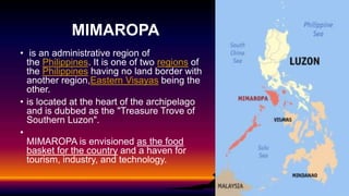


MIMAROPA is an administrative region of the Philippines located in southern Luzon. It consists of 5 provinces: Occidental Mindoro, Oriental Mindoro, Marinduque, Romblon, and Palawan. MIMAROPA has a tropical climate with wet and dry seasons. The region aims to be the country's food basket and a tourism and industry hub. Key attractions across the provinces include Puerto Galera in Oriental Mindoro, Tamaraw Falls in Mindoro, Paadjao Falls in Marinduque, Cantingas River in Romblon, and the underground river in Palawan. The region produces rice and has natural resources like gas deposits off Palawan.