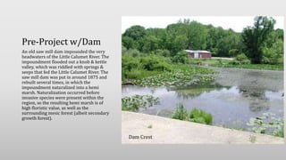
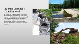
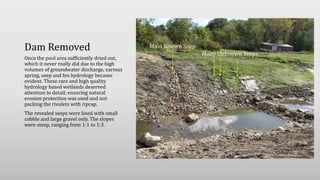
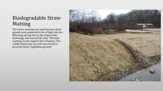
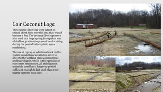
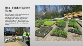
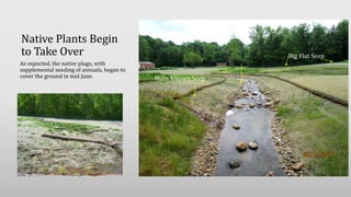
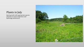
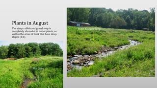
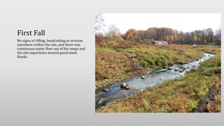
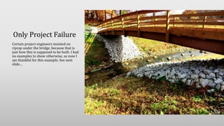
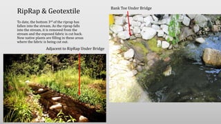
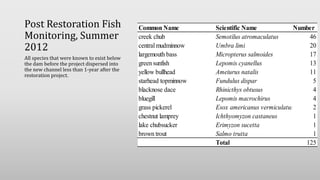
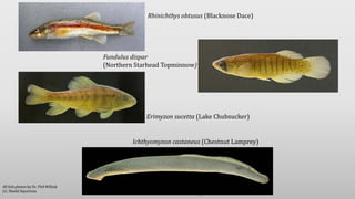
Red Mill Pond
Great Lakes Fishery & Ecosystem
Restoration Program
Section 506, WRDA 2002
Restoration of Stream, Wet Meadow, Spring & Seep Habitats
w/ Naturally Steep Slopes
Pre-Project w/Dam
An old saw mill dam impounded the very
headwaters of the Little Calumet River. The
impoundment flooded out a knob & kettle
valley, which was riddled with springs &
seeps that fed the Little Calumet River. The
saw mill dam was put in around 1875 and
rebuilt several times, in which the
impoundment naturalized into a hemi
marsh. Naturalization occurred before
invasive species were present within the
region, so the resulting hemi marsh is of
high floristic value, as well as the
surrounding mesic forest (albeit secondary
growth forest).
Dam Crest
By-Pass Channel &
Dam Removal
A temporary bypass channel was created
to allow water to continually flow down
stream while the dam was being removed
and while the construction of the new
channel was implemented. Once the new
channel was restored, the temporary
bypass channel was turned back into wet
meadow.
Creation of New
Stream Channel
Once the impoundment was dewatered,
creation of the new channel was
implemented. This consisted of creating a
linear depression what the stream path
was to go. Then natural substrates and
boulder riffles were placed in the stream
channel to a) provide dynamic stability, b)
provide substrates indicative of the reach
and c) provide habitat for
macroinvertebrates and fishes.
Past practices would have lined the whole
channel with quarried, angular riprap,
which is equivalent to a concrete channel
as far as biodiversity is concerned.
Dam Removed
Once the pool area sufficiently dried out,
which it never really did due to the high
volumes of groundwater discharge, various
spring, seep and fen hydrology became
evident. These rare and high quality
hydrology based wetlands deserved
attention to detail; ensuring natural
erosion protection was used and not
packing the rivulets with riprap.
The revealed seeps were lined with small
cobble and large gravel only. The slopes
were steep, ranging from 1:1 to 1:3.
Main Known Seep
Many Unknown Seeps
Biodegradable Straw
Matting
The straw matting was used because plant
growth was suspected to be of high rate the
following spring due to the impeccable
hydrology and natural till soils. This thin
matting would support this situation. The
cobble lined seep was left uncovered to
promote faster vegetation growth.
Coir Coconut Logs
The coconut fiber logs were added to
spread sheet flow over the area that would
become a fen. The coconut fiber logs were
also used in a large spring & seep that was
of shallow gradient to prevent head-cutting
during the period before plants were
established.
The use of riprap or additional rock in this
system would have created an adverse
affect to the wetland plant communities
and hydrologies, which is the opposite of
ecosystem restoration. All stabilization
materials used had a longevity period
sufficient enough to last until plant root
matrix systems took over.
Small Batch of Native
Plants
Nearly 50 species of wetland plants were
plugged into the designated
hydrogeomorphic zones: fen, seep, wet
meadow, marsh, stream. The contract
required both genetic specificity and for
the plants to exhibit a robust vigor, as you
can see in the photo they are extremely
healthy.
Native Plants Begin
to Take Over
As expected, the native plugs, with
supplemental seeding of annuals, began to
cover the ground in mid June. Main Known Seep
Big Flat Seep
Plants in July
Quick growth with appropriate species
selection in terms of genetics and
hydrology preferences.
Plants in August
The steep cobble and gravel seep is
completely shrouded in native plants, as
well as the areas of bank that have steep
slopes (1:1).
Main Known Seep
Flat Seep
First Fall
No signs of rilling, headcutting or erosion
anywhere within the site, and there was
continuous water flow out of the seeps and
the site experience several good sized
floods.
Only Project Failure
Certain project engineers insisted on
riprap under the bridge, because that is
just how this is supposed to be built. I had
no examples to show otherwise, so now I
am thankful for this example. See next
slide…
RipRap & Geotextile
To date, the bottom 3rd of the riprap has
fallen into the stream. As the riprap falls
into the stream, it is removed from the
stream and the exposed fabric is cut back.
Now native plants are filling in these areas
where the fabric is being cut out.
Bank Toe Under Bridge
Adjacent to RipRap Under Bridge
Post Restoration Fish
Monitoring, Summer
2012
All species that were known to exist below
the dam before the project dispersed into
the new channel less than 1-year after the
restoration project.
Common Name Scientific Name Number
creek chub Semotilus atromaculatus 46
centralmudminnow Umbra limi 20
largemouth bass Micropterus salmoides 17
green sunfish Lepomis cyanellus 13
yellow bullhead Ameiurus natalis 11
starhead topminnow Fundulus dispar 5
blacknose dace Rhinicthys obtusus 4
bluegill Lepomis macrochirus 4
grass pickerel Esox americanus vermiculatus 2
chestnut lamprey Ichthyomyzon castaneus 1
lake chubsucker Erimyzon sucetta 1
brown trout Salmo trutta 1
Total 125
16
Rhinichthys obtusus (Blacknose Dace)
Fundulus dispar
(Northern Starhead Topminnow)
Erimyzon sucetta (Lake Chubsucker)
Ichthyomyzon castaneus (Chestnut Lamprey)
All fish photos by Dr. Phil Willink
J.G. Shedd Aquarium

Red millpond506 2016_03_23

  • 1.
    Red Mill Pond GreatLakes Fishery & Ecosystem Restoration Program Section 506, WRDA 2002 Restoration of Stream, Wet Meadow, Spring & Seep Habitats w/ Naturally Steep Slopes
  • 2.
    Pre-Project w/Dam An oldsaw mill dam impounded the very headwaters of the Little Calumet River. The impoundment flooded out a knob & kettle valley, which was riddled with springs & seeps that fed the Little Calumet River. The saw mill dam was put in around 1875 and rebuilt several times, in which the impoundment naturalized into a hemi marsh. Naturalization occurred before invasive species were present within the region, so the resulting hemi marsh is of high floristic value, as well as the surrounding mesic forest (albeit secondary growth forest). Dam Crest
  • 3.
    By-Pass Channel & DamRemoval A temporary bypass channel was created to allow water to continually flow down stream while the dam was being removed and while the construction of the new channel was implemented. Once the new channel was restored, the temporary bypass channel was turned back into wet meadow.
  • 4.
    Creation of New StreamChannel Once the impoundment was dewatered, creation of the new channel was implemented. This consisted of creating a linear depression what the stream path was to go. Then natural substrates and boulder riffles were placed in the stream channel to a) provide dynamic stability, b) provide substrates indicative of the reach and c) provide habitat for macroinvertebrates and fishes. Past practices would have lined the whole channel with quarried, angular riprap, which is equivalent to a concrete channel as far as biodiversity is concerned.
  • 5.
    Dam Removed Once thepool area sufficiently dried out, which it never really did due to the high volumes of groundwater discharge, various spring, seep and fen hydrology became evident. These rare and high quality hydrology based wetlands deserved attention to detail; ensuring natural erosion protection was used and not packing the rivulets with riprap. The revealed seeps were lined with small cobble and large gravel only. The slopes were steep, ranging from 1:1 to 1:3. Main Known Seep Many Unknown Seeps
  • 6.
    Biodegradable Straw Matting The strawmatting was used because plant growth was suspected to be of high rate the following spring due to the impeccable hydrology and natural till soils. This thin matting would support this situation. The cobble lined seep was left uncovered to promote faster vegetation growth.
  • 7.
    Coir Coconut Logs Thecoconut fiber logs were added to spread sheet flow over the area that would become a fen. The coconut fiber logs were also used in a large spring & seep that was of shallow gradient to prevent head-cutting during the period before plants were established. The use of riprap or additional rock in this system would have created an adverse affect to the wetland plant communities and hydrologies, which is the opposite of ecosystem restoration. All stabilization materials used had a longevity period sufficient enough to last until plant root matrix systems took over.
  • 8.
    Small Batch ofNative Plants Nearly 50 species of wetland plants were plugged into the designated hydrogeomorphic zones: fen, seep, wet meadow, marsh, stream. The contract required both genetic specificity and for the plants to exhibit a robust vigor, as you can see in the photo they are extremely healthy.
  • 9.
    Native Plants Begin toTake Over As expected, the native plugs, with supplemental seeding of annuals, began to cover the ground in mid June. Main Known Seep Big Flat Seep
  • 10.
    Plants in July Quickgrowth with appropriate species selection in terms of genetics and hydrology preferences.
  • 11.
    Plants in August Thesteep cobble and gravel seep is completely shrouded in native plants, as well as the areas of bank that have steep slopes (1:1). Main Known Seep Flat Seep
  • 12.
    First Fall No signsof rilling, headcutting or erosion anywhere within the site, and there was continuous water flow out of the seeps and the site experience several good sized floods.
  • 13.
    Only Project Failure Certainproject engineers insisted on riprap under the bridge, because that is just how this is supposed to be built. I had no examples to show otherwise, so now I am thankful for this example. See next slide…
  • 14.
    RipRap & Geotextile Todate, the bottom 3rd of the riprap has fallen into the stream. As the riprap falls into the stream, it is removed from the stream and the exposed fabric is cut back. Now native plants are filling in these areas where the fabric is being cut out. Bank Toe Under Bridge Adjacent to RipRap Under Bridge
  • 15.
    Post Restoration Fish Monitoring,Summer 2012 All species that were known to exist below the dam before the project dispersed into the new channel less than 1-year after the restoration project. Common Name Scientific Name Number creek chub Semotilus atromaculatus 46 centralmudminnow Umbra limi 20 largemouth bass Micropterus salmoides 17 green sunfish Lepomis cyanellus 13 yellow bullhead Ameiurus natalis 11 starhead topminnow Fundulus dispar 5 blacknose dace Rhinicthys obtusus 4 bluegill Lepomis macrochirus 4 grass pickerel Esox americanus vermiculatus 2 chestnut lamprey Ichthyomyzon castaneus 1 lake chubsucker Erimyzon sucetta 1 brown trout Salmo trutta 1 Total 125
  • 16.
    16 Rhinichthys obtusus (BlacknoseDace) Fundulus dispar (Northern Starhead Topminnow) Erimyzon sucetta (Lake Chubsucker) Ichthyomyzon castaneus (Chestnut Lamprey) All fish photos by Dr. Phil Willink J.G. Shedd Aquarium