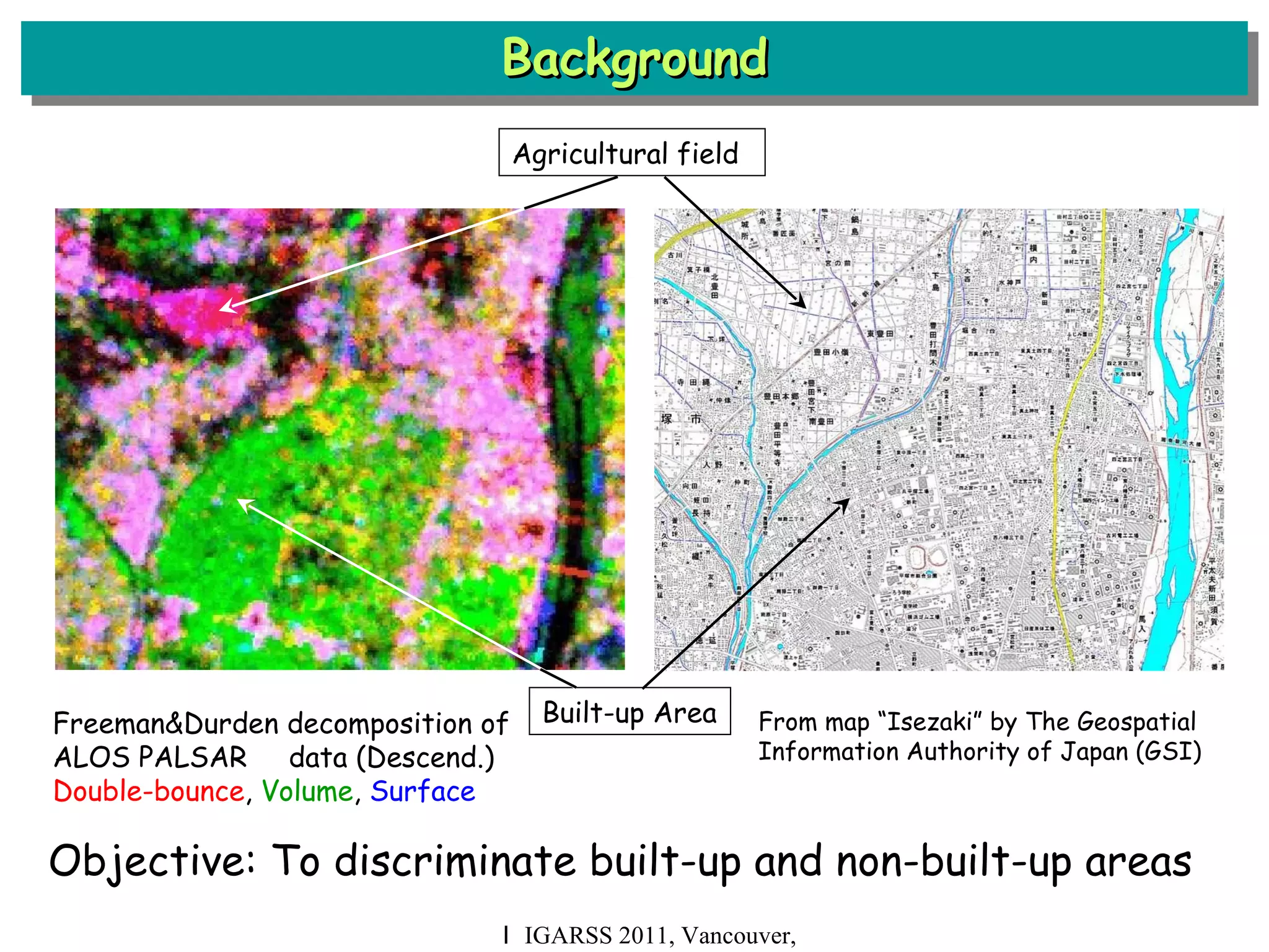
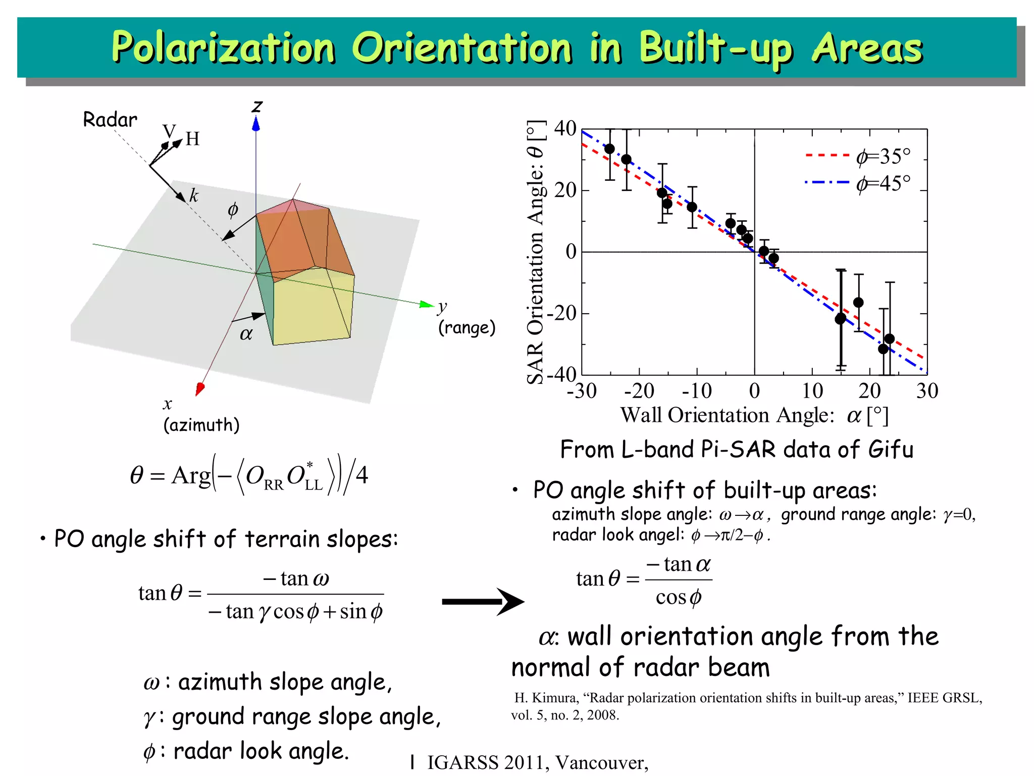
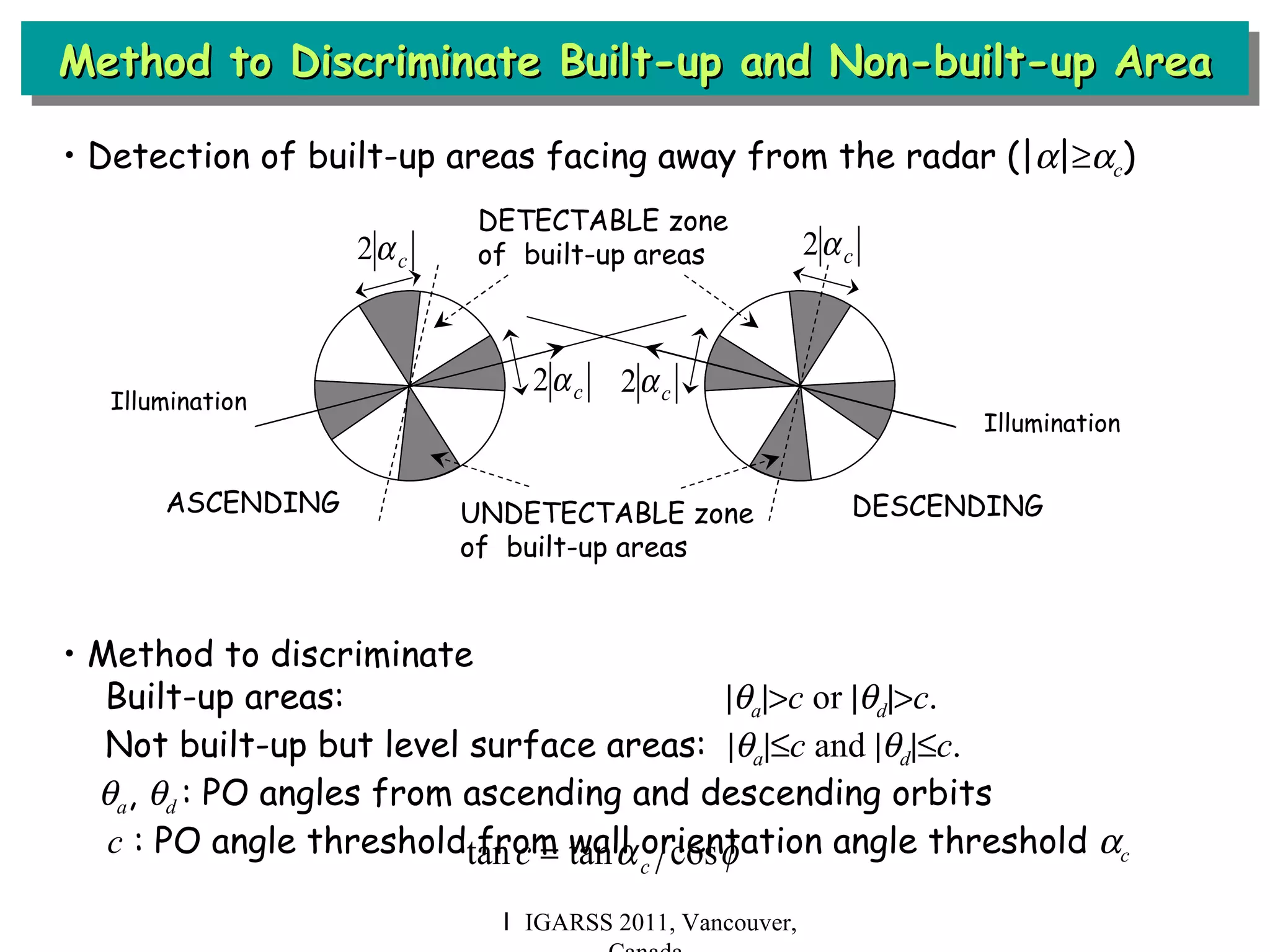
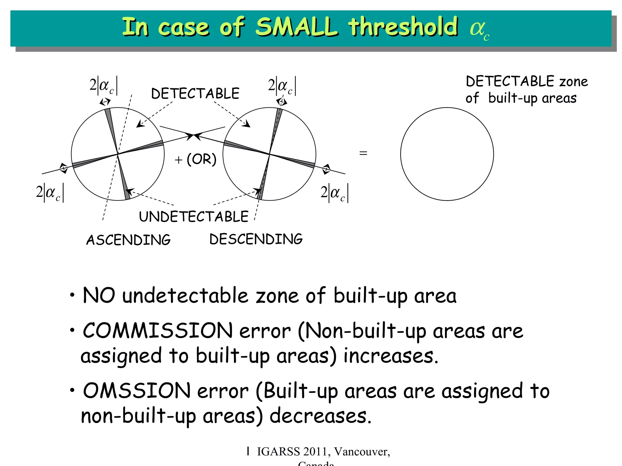
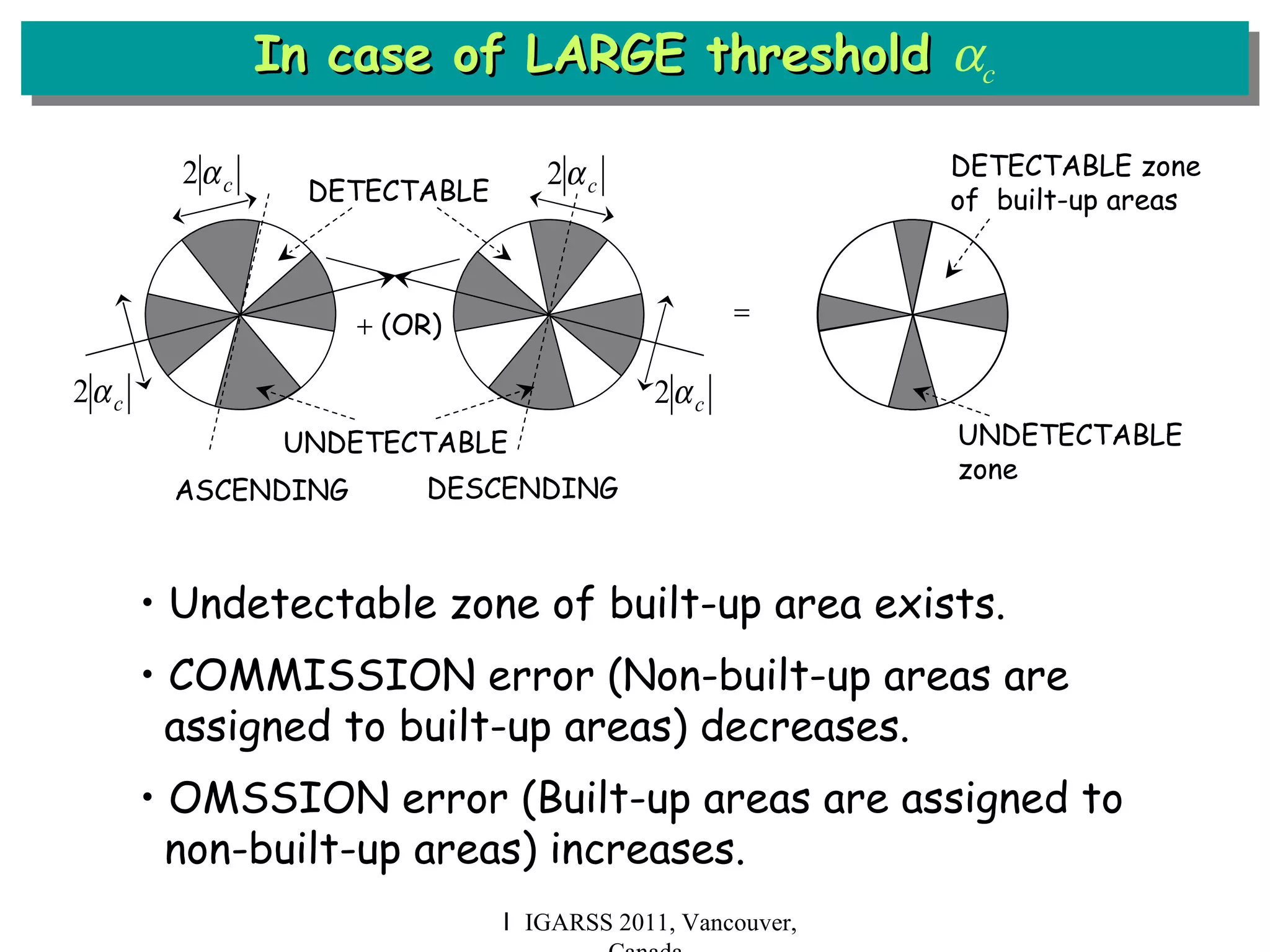
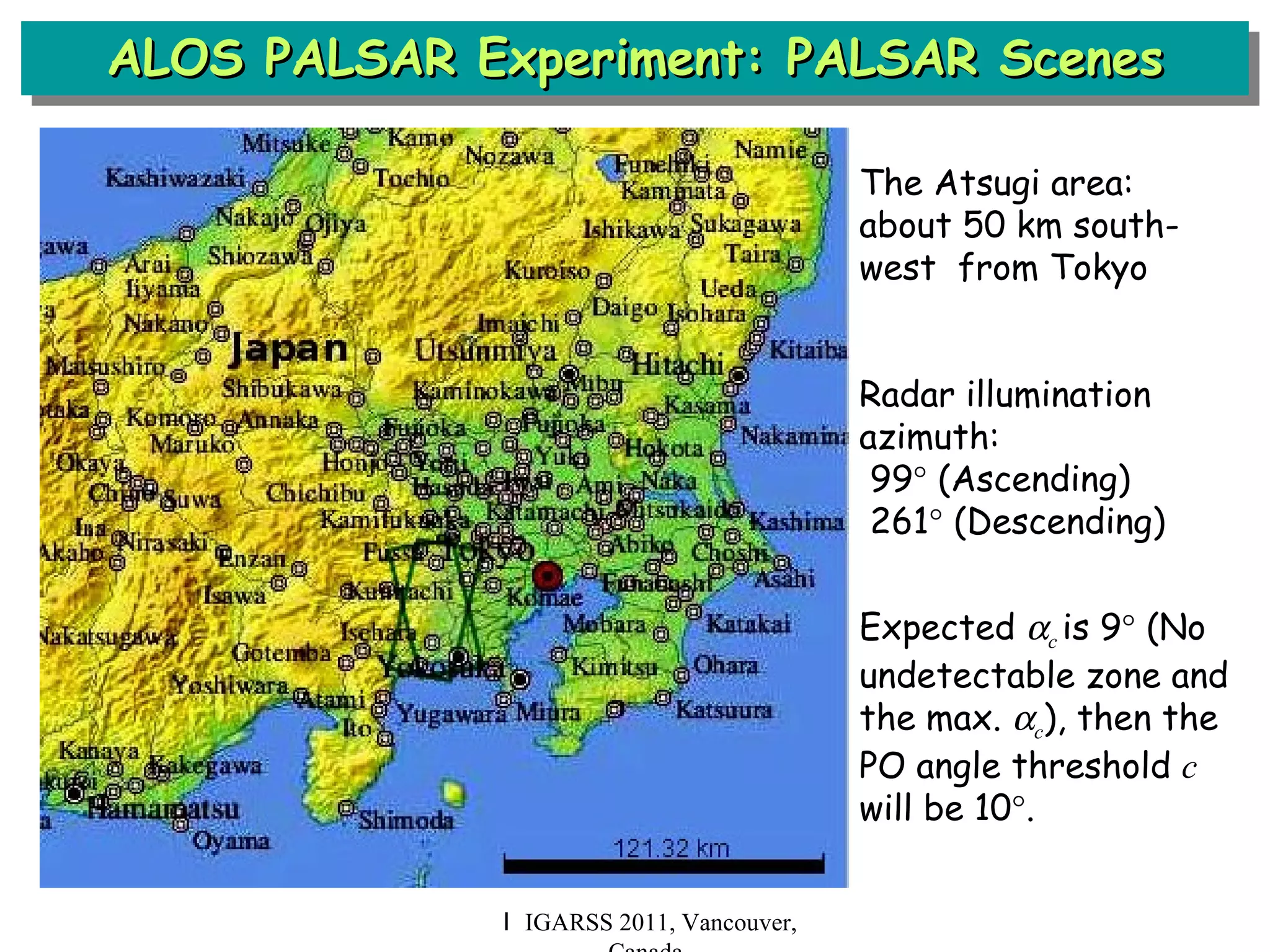
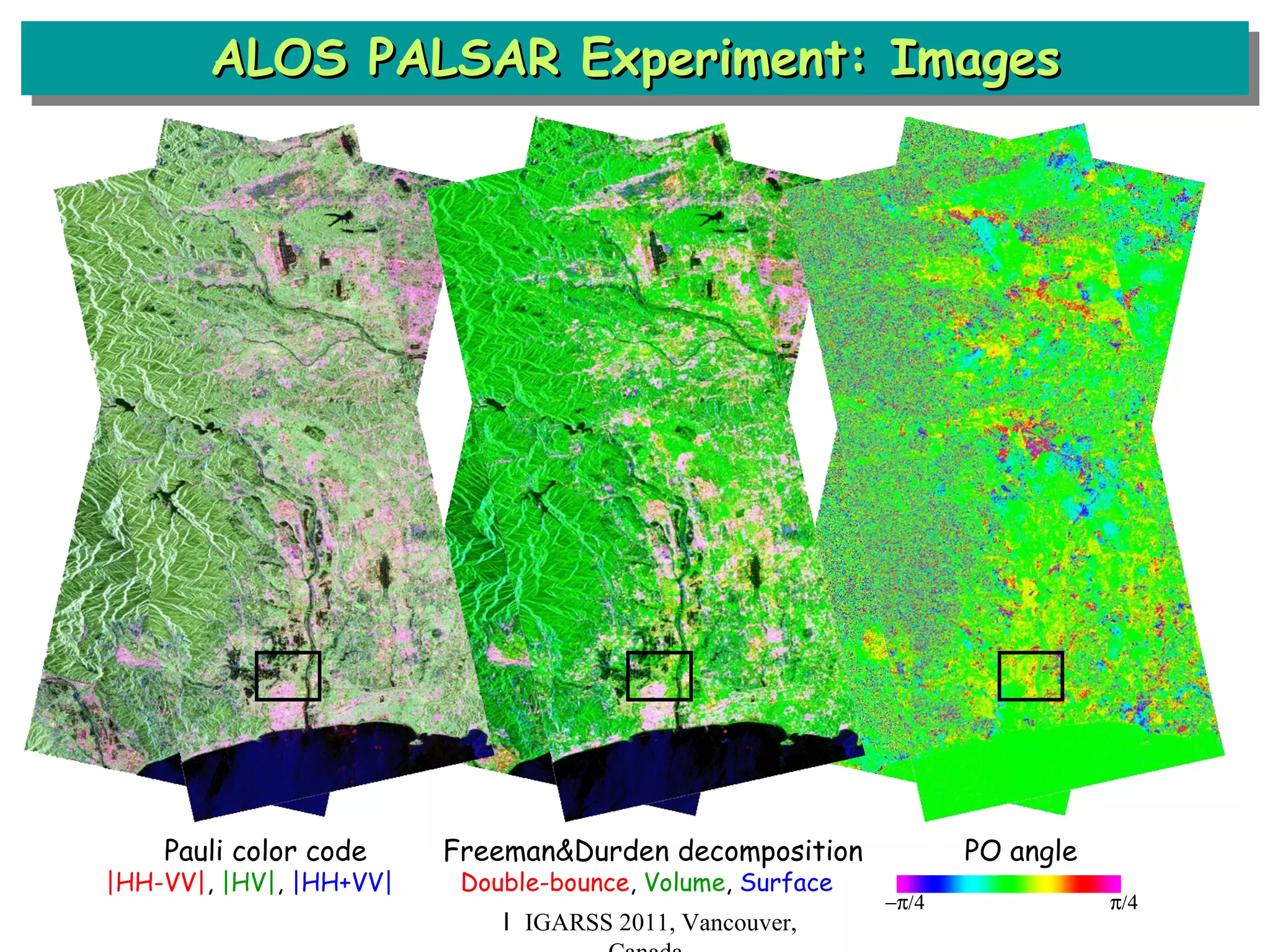
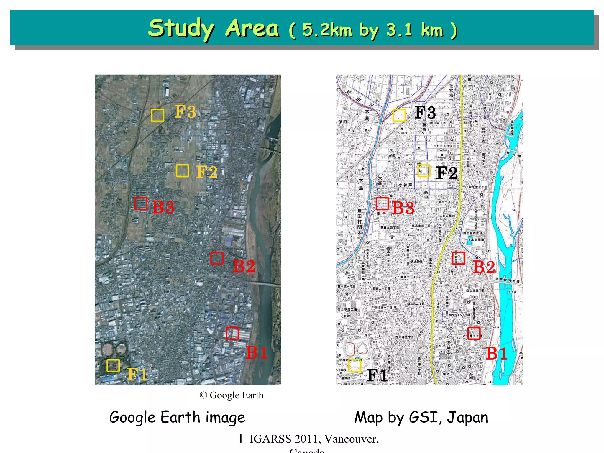
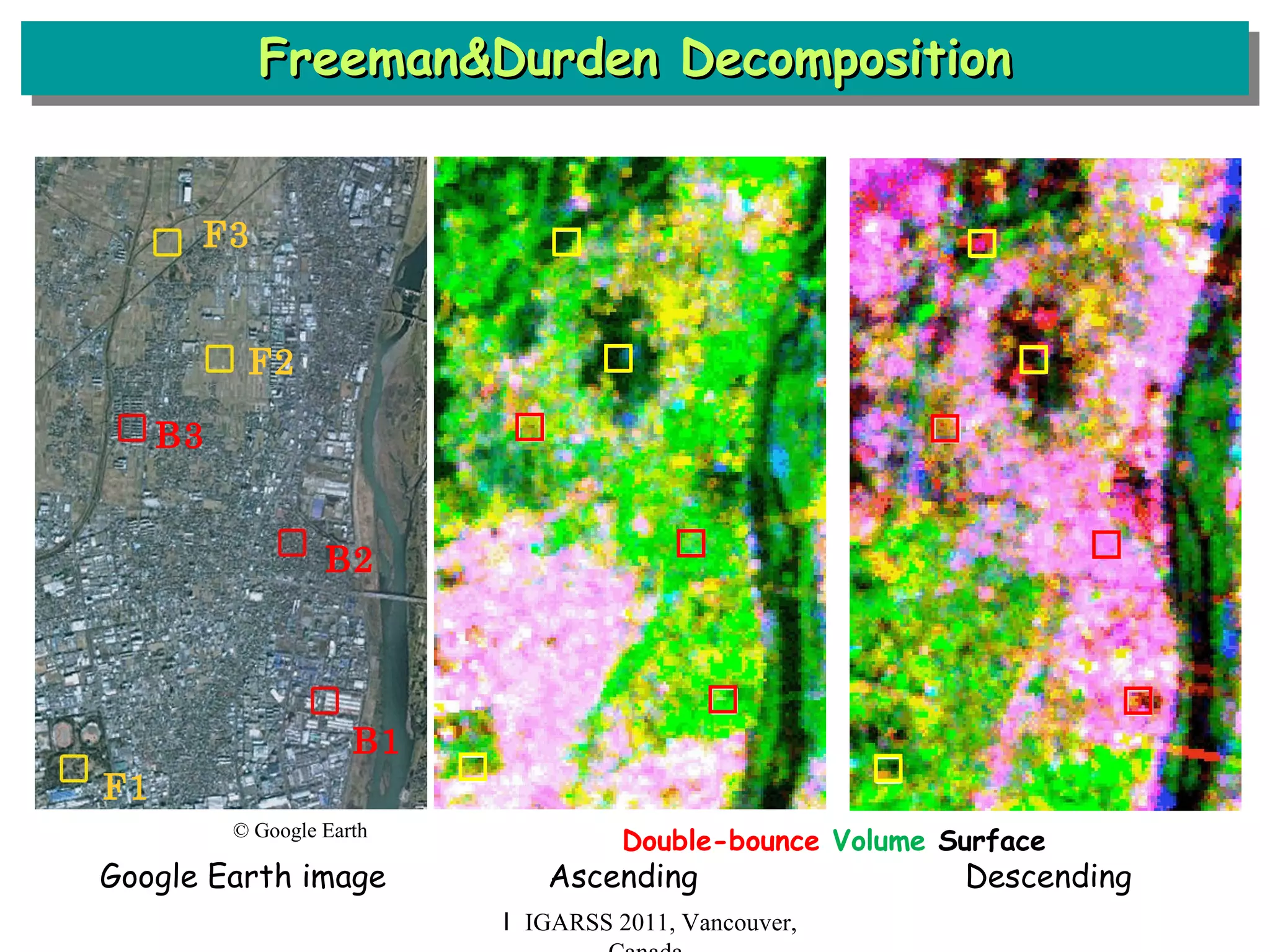
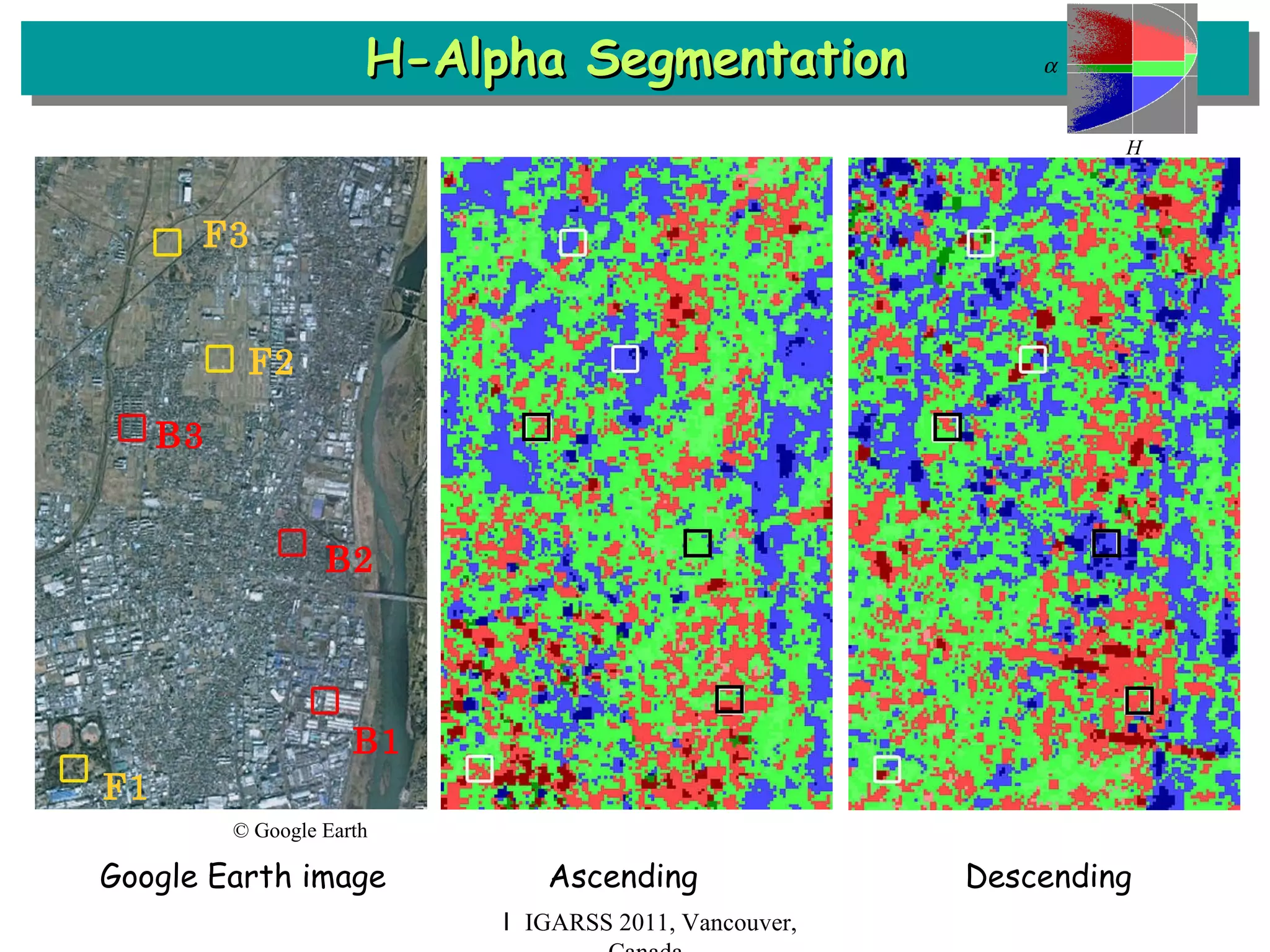
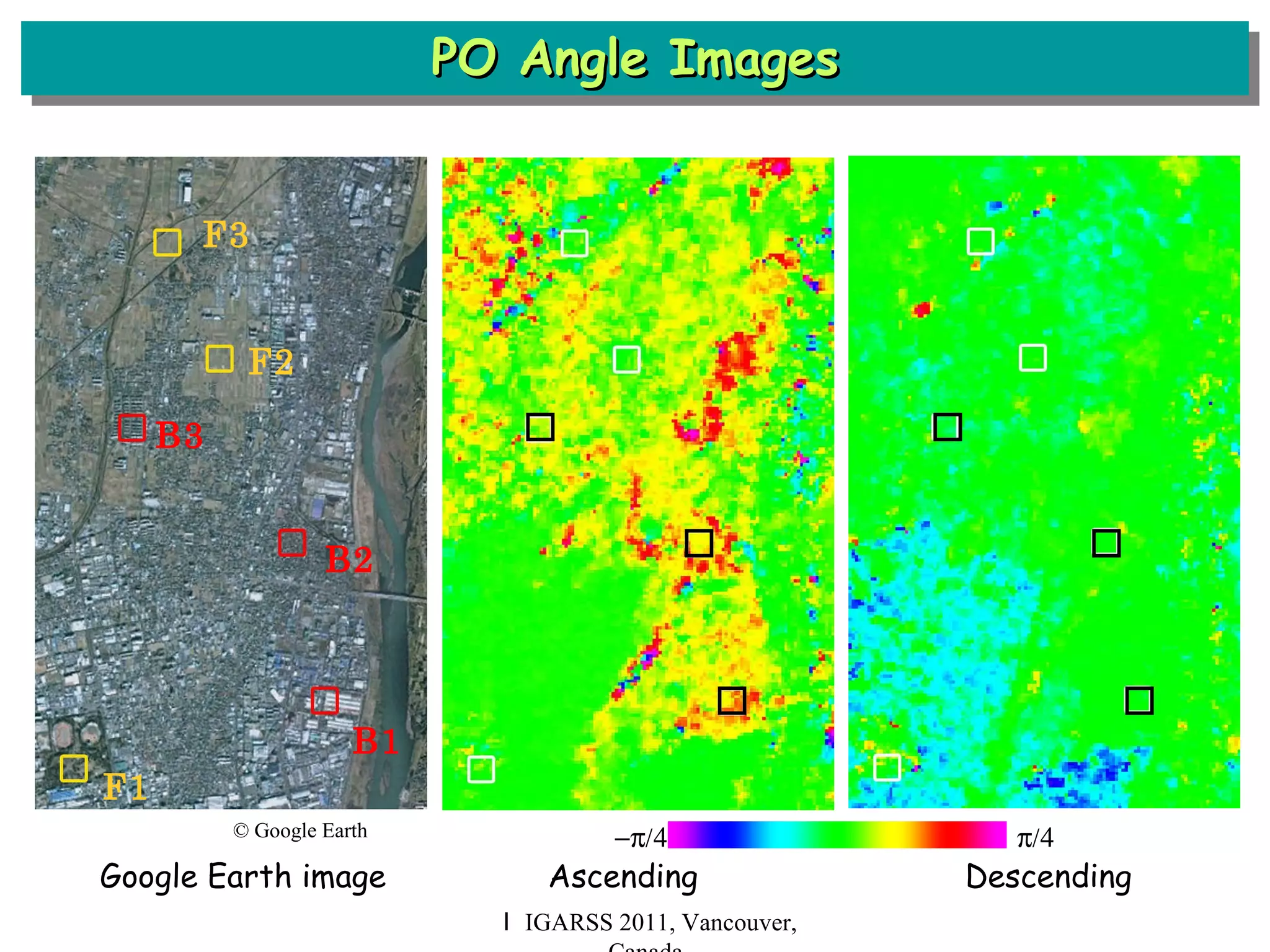
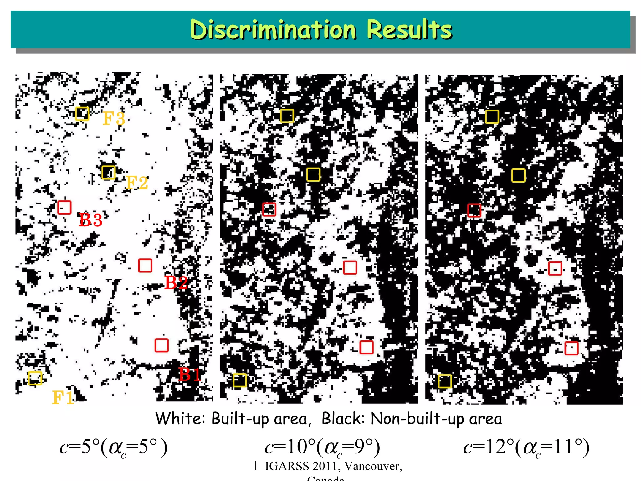
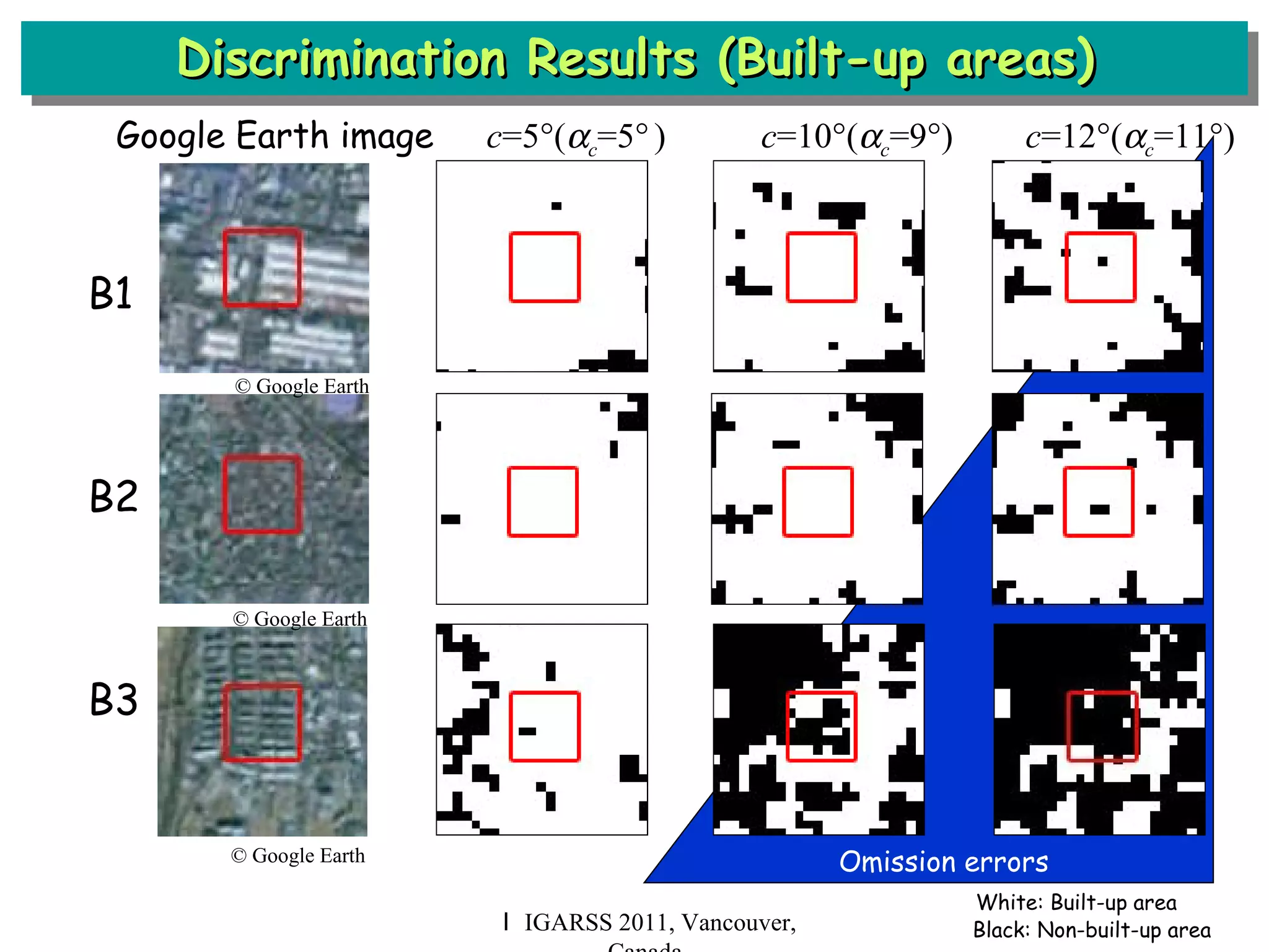
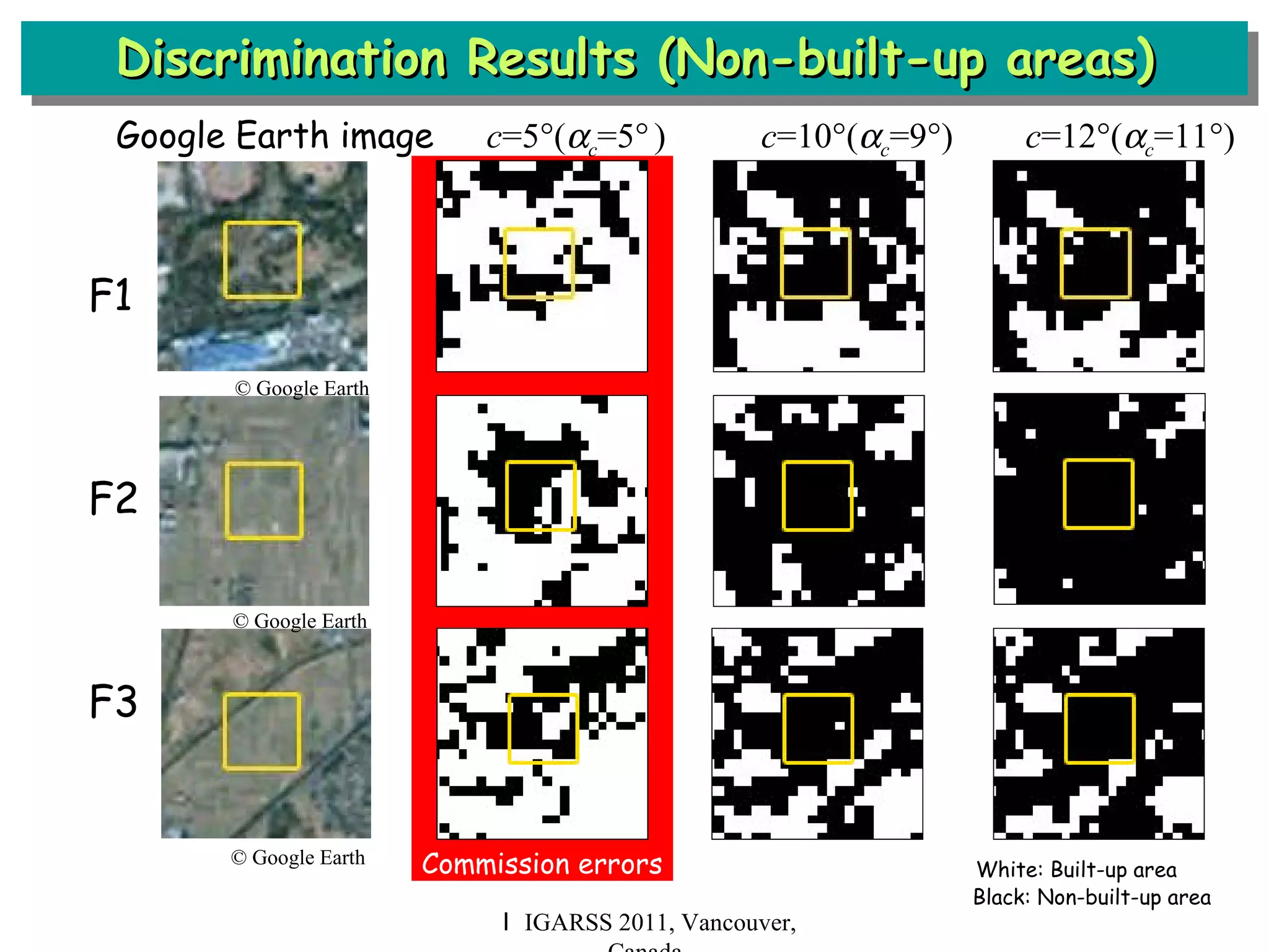
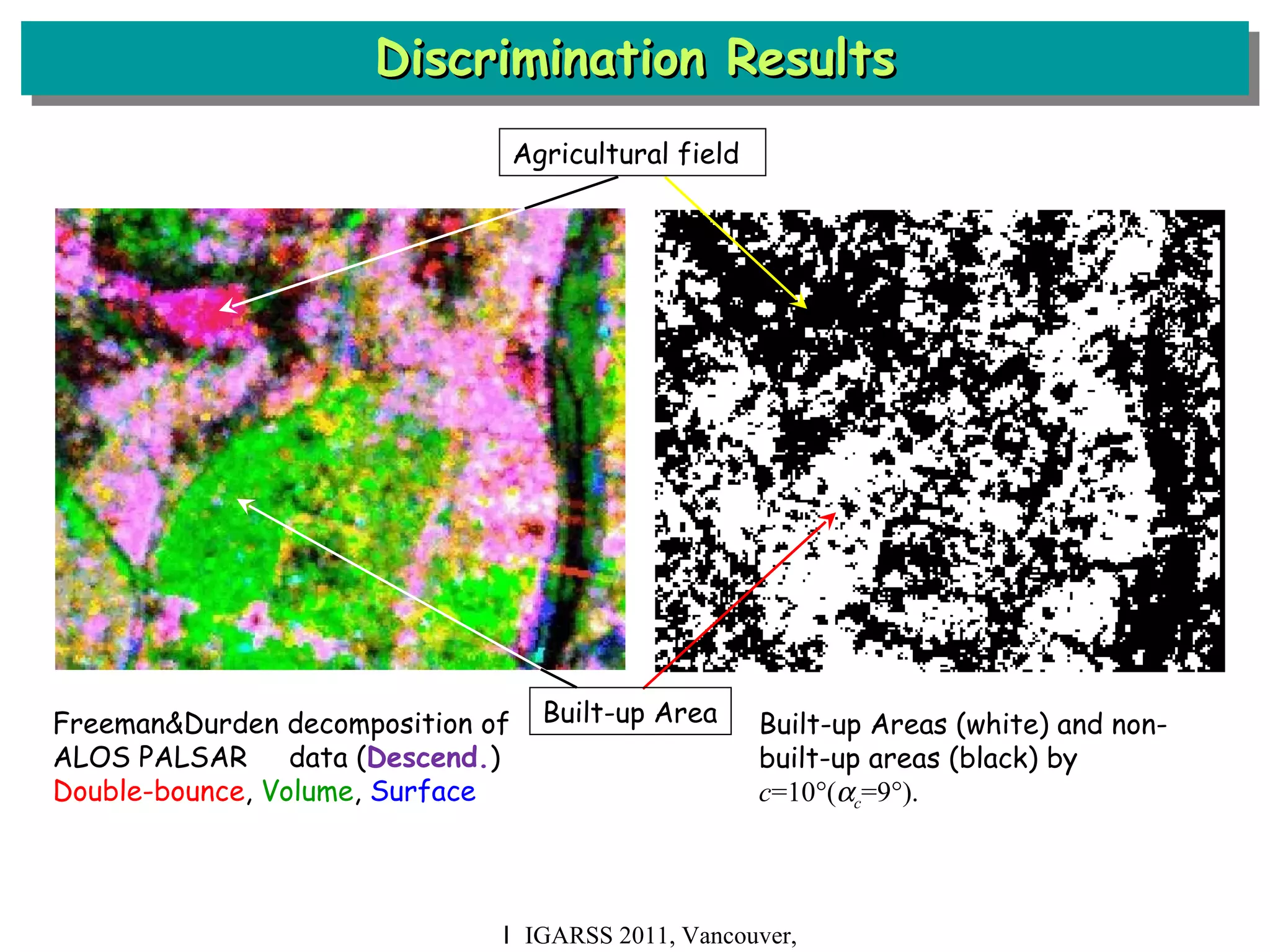
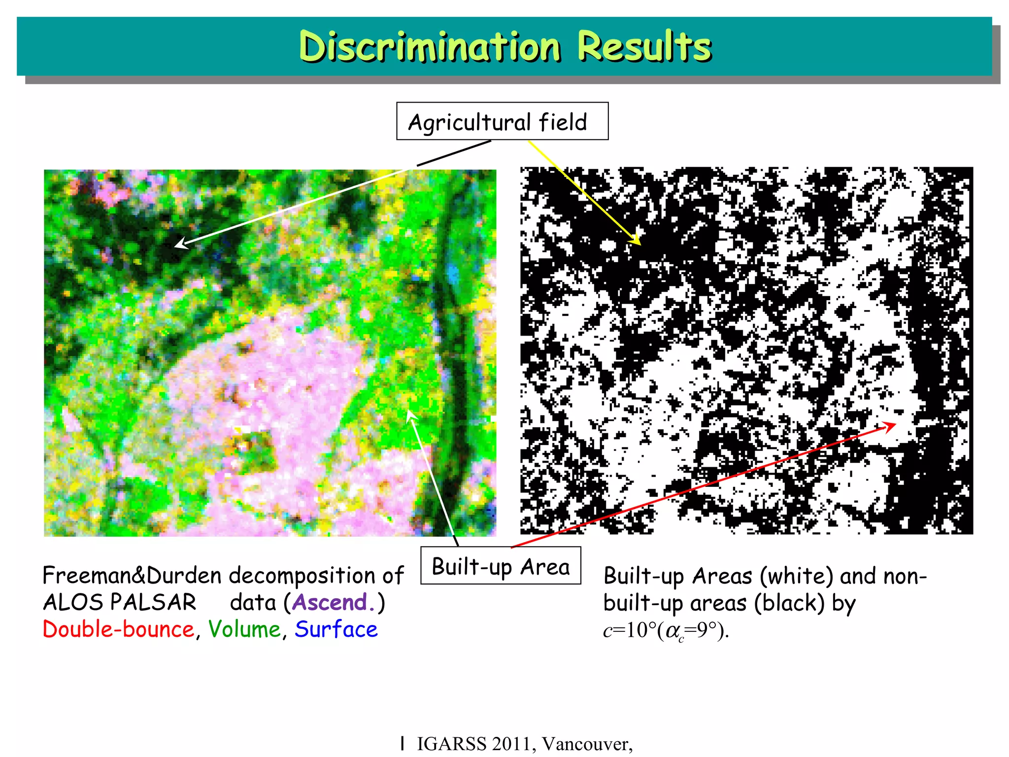
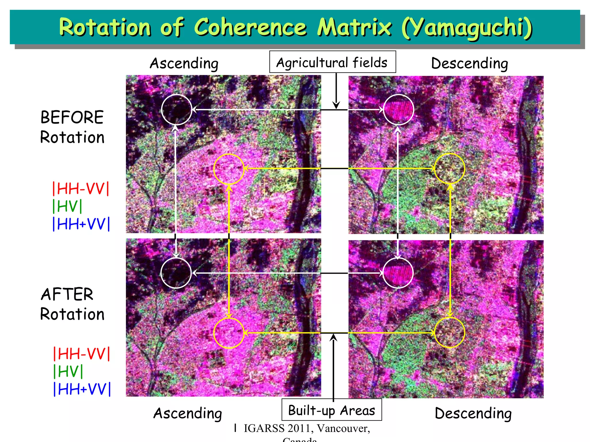
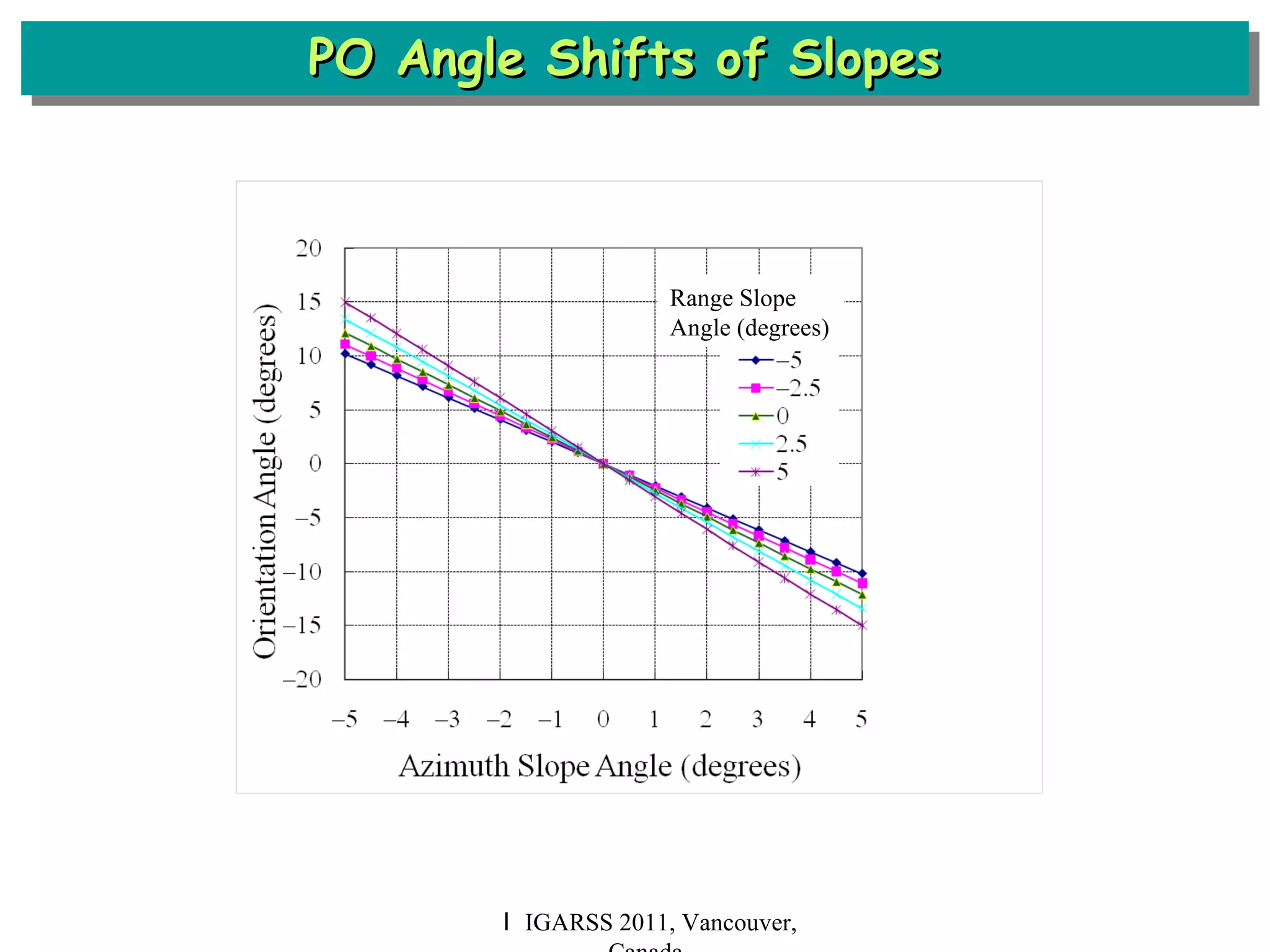
On The Use of Polarimetric Orientation for POLSAR Classification and Decomposition Hiroshi Kimura Gifu University, Japan IGARSS 2011 Vancouver, Canada July 25, 2011
Contents Background Polarization Orientation in Built-up Areas Method to Discriminate Built-up and Non-built-up Areas ALOS PALSAR Experiment Conclusion I IGARSS 2011, Vancouver, Canada
Background I IGARSS 2011, Vancouver, Canada Freeman&Durden decomposition of ALOS PALSAR   data (Descend.) Double-bounce ,  Volume ,  Surface From map “Isezaki” by The Geospatial Information Authority of Japan (GSI) Agricultural field Built-up Area Objective: To discriminate built-up and non-built-up areas
Polarization Orientation in Built-up Areas •  PO angle shift of terrain slopes:    : azimuth slope angle,    : ground range slope angle,  : radar look angle. z •  PO angle shift of built-up areas:  azimuth slope angle:       ground range angle:    radar look angel:       wall orientation angle from the normal of radar beam H. Kimura, “Radar polarization orientation shifts in built-up areas,” IEEE GRSL, vol. 5, no. 2, 2008. From L-band Pi-SAR data of Gifu I IGARSS 2011, Vancouver, Canada Radar x  (azimuth) y (range) V H k  
Method to Discriminate Built-up and Non-built-up Area I IGARSS 2011, Vancouver, Canada •  Detection of built-up areas facing away from the radar (|  |   c )  •  Method to discriminate Built-up areas:    a  c  or   d  c  Not built-up but level surface areas:    a  c  and    d  c   a ,   d  : PO angles from ascending and descending orbits c  : PO angle threshold from wall orientation angle threshold   c Illumination Illumination UNDETECTABLE zone of  built-up areas DETECTABLE zone of  built-up areas ASCENDING DESCENDING
I IGARSS 2011, Vancouver, Canada In case of SMALL threshold   c      (OR) ASCENDING DESCENDING DETECTABLE zone of  built-up areas  •  NO undetectable zone of built-up area •  COMMISSION error (Non-built-up areas are assigned to built-up areas) increases. •  OMSSION error (Built-up areas are assigned to non-built-up areas) decreases. UNDETECTABLE  DETECTABLE
I IGARSS 2011, Vancouver, Canada In case of LARGE threshold   c      (OR) ASCENDING DESCENDING DETECTABLE zone of  built-up areas  UNDETECTABLE zone •  Undetectable zone of built-up area exists. •  COMMISSION error (Non-built-up areas are assigned to built-up areas) decreases. •  OMSSION error (Built-up areas are assigned to non-built-up areas) increases. UNDETECTABLE  DETECTABLE
ALOS PALSAR Experiment: PALSAR Scenes I IGARSS 2011, Vancouver, Canada The Atsugi area: about 50 km south-west  from Tokyo Radar illumination azimuth: 99   (Ascending) 261   (Descending) Expected   c  is 9   (No undetectable zone and the max.   c ), then the PO angle threshold  c  will be 10  .
ALOS PALSAR Experiment: Images I IGARSS 2011, Vancouver, Canada Pauli color code  Freeman&Durden decomposition  PO angle |HH-VV| ,  |HV| ,  |HH+VV|   Double-bounce ,  Volume ,  Surface 
Study Area  ( 5.2km by 3.1 km ) I IGARSS 2011, Vancouver, Canada B3 F3 B2 B1 F2 F1 Google Earth image  Map by GSI, Japan B3 F3 B2 B1 F2 F1 © Google Earth
Freeman&Durden Decomposition I IGARSS 2011, Vancouver, Canada Google Earth image  Ascending  Descending B3 F3 B2 B1 F2 F1 Double-bounce   Volume   Surface © Google Earth
H-Alpha Segmentation I IGARSS 2011, Vancouver, Canada Google Earth image  Ascending  Descending © Google Earth B3 F3 B2 B1 F2 F1 H 
PO Angle Images I IGARSS 2011, Vancouver, Canada  Google Earth image  Ascending  Descending © Google Earth B3 F3 B2 B1 F2 F1
Discrimination Results I IGARSS 2011, Vancouver, Canada c =5  (  c =5    )   c =10  (  c =9  )   c =12  (  c =11  ) White: Built-up area,  Black: Non-built-up area B3 F3 B2 B1 F2 F1
Discrimination Results (Built-up areas) I IGARSS 2011, Vancouver, Canada © Google Earth © Google Earth © Google Earth B1 B2 B3 White: Built-up area Black: Non-built-up area Google Earth image  c =5  (  c =5    )   c =10  (  c =9  )   c =12  (  c =11  ) Omission errors
Discrimination Results (Non-built-up areas) I IGARSS 2011, Vancouver, Canada © Google Earth © Google Earth © Google Earth F1 F2 F3 Commission errors White: Built-up area Black: Non-built-up area Google Earth image  c =5  (  c =5    )   c =10  (  c =9  )   c =12  (  c =11  )
Discrimination Results I IGARSS 2011, Vancouver, Canada Freeman&Durden decomposition of ALOS PALSAR   data ( Descend. ) Double-bounce ,  Volume ,  Surface Built-up Areas (white) and non-built-up areas (black) by  c =10  (  c =9  ).   Agricultural field Built-up Area
Discrimination Results I IGARSS 2011, Vancouver, Canada Freeman&Durden decomposition of ALOS PALSAR   data ( Ascend. ) Double-bounce ,  Volume ,  Surface Built-up Areas (white) and non-built-up areas (black) by  c =10  (  c =9  ).   Agricultural field Built-up Area
Conclusion I IGARSS 2011, Vancouver, Canada PO from ascending and descending orbits can be used to discriminate built-up and non-built-up areas. Radar illumination direction influences POLSAR data aanlysis. The discrimination prevents  misleading of POLSAR decomposition and classification. (Volume scattering in urban areas, double bounce in agricultural fields, et al.) The expected threshold with no undetectable zone of built-up areas and the maximum number seems to be good, but a further study is required for the best one . Slopes should be separated.
Rotation of Coherence Matrix (Yamaguchi) I IGARSS 2011, Vancouver, Canada BEFORE Rotation AFTER Rotation Agricultural fields Built-up Areas |HH-VV| |HV| |HH+VV| Ascending       Descending |HH-VV| |HV| |HH+VV| Ascending       Descending
PO Angle Shifts of Slopes  I IGARSS 2011, Vancouver, Canada Range Slope Angle (degrees)

recent advances in scvattering model-based decompositions

  • 1.
    On The Useof Polarimetric Orientation for POLSAR Classification and Decomposition Hiroshi Kimura Gifu University, Japan IGARSS 2011 Vancouver, Canada July 25, 2011
  • 2.
    Contents Background PolarizationOrientation in Built-up Areas Method to Discriminate Built-up and Non-built-up Areas ALOS PALSAR Experiment Conclusion I IGARSS 2011, Vancouver, Canada
  • 3.
    Background I IGARSS2011, Vancouver, Canada Freeman&Durden decomposition of ALOS PALSAR   data (Descend.) Double-bounce , Volume , Surface From map “Isezaki” by The Geospatial Information Authority of Japan (GSI) Agricultural field Built-up Area Objective: To discriminate built-up and non-built-up areas
  • 4.
    Polarization Orientation inBuilt-up Areas • PO angle shift of terrain slopes:  : azimuth slope angle,  : ground range slope angle,  : radar look angle. z • PO angle shift of built-up areas: azimuth slope angle:    ground range angle:   radar look angel:      wall orientation angle from the normal of radar beam H. Kimura, “Radar polarization orientation shifts in built-up areas,” IEEE GRSL, vol. 5, no. 2, 2008. From L-band Pi-SAR data of Gifu I IGARSS 2011, Vancouver, Canada Radar x (azimuth) y (range) V H k  
  • 5.
    Method to DiscriminateBuilt-up and Non-built-up Area I IGARSS 2011, Vancouver, Canada • Detection of built-up areas facing away from the radar (|  |   c ) • Method to discriminate Built-up areas:   a  c  or   d  c  Not built-up but level surface areas:   a  c and   d  c   a ,  d : PO angles from ascending and descending orbits c : PO angle threshold from wall orientation angle threshold  c Illumination Illumination UNDETECTABLE zone of built-up areas DETECTABLE zone of built-up areas ASCENDING DESCENDING
  • 6.
    I IGARSS 2011,Vancouver, Canada In case of SMALL threshold  c  (OR) ASCENDING DESCENDING DETECTABLE zone of built-up areas  • NO undetectable zone of built-up area • COMMISSION error (Non-built-up areas are assigned to built-up areas) increases. • OMSSION error (Built-up areas are assigned to non-built-up areas) decreases. UNDETECTABLE DETECTABLE
  • 7.
    I IGARSS 2011,Vancouver, Canada In case of LARGE threshold  c  (OR) ASCENDING DESCENDING DETECTABLE zone of built-up areas  UNDETECTABLE zone • Undetectable zone of built-up area exists. • COMMISSION error (Non-built-up areas are assigned to built-up areas) decreases. • OMSSION error (Built-up areas are assigned to non-built-up areas) increases. UNDETECTABLE DETECTABLE
  • 8.
    ALOS PALSAR Experiment:PALSAR Scenes I IGARSS 2011, Vancouver, Canada The Atsugi area: about 50 km south-west from Tokyo Radar illumination azimuth: 99  (Ascending) 261  (Descending) Expected  c is 9  (No undetectable zone and the max.  c ), then the PO angle threshold c will be 10  .
  • 9.
    ALOS PALSAR Experiment:Images I IGARSS 2011, Vancouver, Canada Pauli color code Freeman&Durden decomposition PO angle |HH-VV| , |HV| , |HH+VV| Double-bounce , Volume , Surface 
  • 10.
    Study Area ( 5.2km by 3.1 km ) I IGARSS 2011, Vancouver, Canada B3 F3 B2 B1 F2 F1 Google Earth image Map by GSI, Japan B3 F3 B2 B1 F2 F1 © Google Earth
  • 11.
    Freeman&Durden Decomposition IIGARSS 2011, Vancouver, Canada Google Earth image Ascending Descending B3 F3 B2 B1 F2 F1 Double-bounce Volume Surface © Google Earth
  • 12.
    H-Alpha Segmentation IIGARSS 2011, Vancouver, Canada Google Earth image Ascending Descending © Google Earth B3 F3 B2 B1 F2 F1 H 
  • 13.
    PO Angle ImagesI IGARSS 2011, Vancouver, Canada  Google Earth image Ascending Descending © Google Earth B3 F3 B2 B1 F2 F1
  • 14.
    Discrimination Results IIGARSS 2011, Vancouver, Canada c =5  (  c =5  ) c =10  (  c =9  ) c =12  (  c =11  ) White: Built-up area, Black: Non-built-up area B3 F3 B2 B1 F2 F1
  • 15.
    Discrimination Results (Built-upareas) I IGARSS 2011, Vancouver, Canada © Google Earth © Google Earth © Google Earth B1 B2 B3 White: Built-up area Black: Non-built-up area Google Earth image c =5  (  c =5  ) c =10  (  c =9  ) c =12  (  c =11  ) Omission errors
  • 16.
    Discrimination Results (Non-built-upareas) I IGARSS 2011, Vancouver, Canada © Google Earth © Google Earth © Google Earth F1 F2 F3 Commission errors White: Built-up area Black: Non-built-up area Google Earth image c =5  (  c =5  ) c =10  (  c =9  ) c =12  (  c =11  )
  • 17.
    Discrimination Results IIGARSS 2011, Vancouver, Canada Freeman&Durden decomposition of ALOS PALSAR   data ( Descend. ) Double-bounce , Volume , Surface Built-up Areas (white) and non-built-up areas (black) by c =10  (  c =9  ). Agricultural field Built-up Area
  • 18.
    Discrimination Results IIGARSS 2011, Vancouver, Canada Freeman&Durden decomposition of ALOS PALSAR   data ( Ascend. ) Double-bounce , Volume , Surface Built-up Areas (white) and non-built-up areas (black) by c =10  (  c =9  ). Agricultural field Built-up Area
  • 19.
    Conclusion I IGARSS2011, Vancouver, Canada PO from ascending and descending orbits can be used to discriminate built-up and non-built-up areas. Radar illumination direction influences POLSAR data aanlysis. The discrimination prevents misleading of POLSAR decomposition and classification. (Volume scattering in urban areas, double bounce in agricultural fields, et al.) The expected threshold with no undetectable zone of built-up areas and the maximum number seems to be good, but a further study is required for the best one . Slopes should be separated.
  • 20.
    Rotation of CoherenceMatrix (Yamaguchi) I IGARSS 2011, Vancouver, Canada BEFORE Rotation AFTER Rotation Agricultural fields Built-up Areas |HH-VV| |HV| |HH+VV| Ascending      Descending |HH-VV| |HV| |HH+VV| Ascending      Descending
  • 21.
    PO Angle Shiftsof Slopes I IGARSS 2011, Vancouver, Canada Range Slope Angle (degrees)