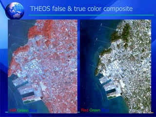
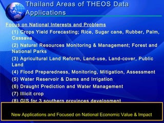
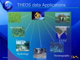
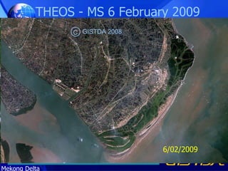
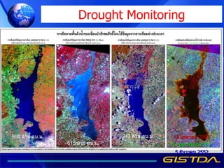
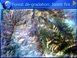
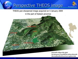
Geo-informatics and Space Technology Development Agency (Public Organization) : GISTDA THEOS Applications
THEOS Satellite Mass:  750 kg. Orbit:  Sun Synchronous Altitude:  822 km. Inclination:  98.7 Repeat Cycle:  26 days Mean Local Time:  10.00 a.m. Payload:  - Panchromatic telescope - Multi-spectral camera On-board Memory:  51Gb Mission Data:  X-band Link TT&C:  S-band Link Design Life Time:  at least  5 yrs S band antenna Star tracker X band antenna Panchromatic telescope Multispectral  camera Solar array Thermal radiator Gyroscopes
Acquisition Capabilities Imaging Mode -  Multi target mode -  Covering or Strip imaging Repeat Viewing Capabilities Stereoscopic Capabilities
THEOS Imagery PAN MS Resolution 2m. 15m. Imaging swath 22 x 22 km. 90 x 90 km. Spectral ranges (µm) P: 0.45 - 0.90 B1(blue):0.45-0.52 B2(green):0.53-0.6 B3(red):0.62-0.69 B4(NIR):0.77-0.90
Bangkok and vicinity area Acquisition: 4 December 2008 Panchromatic & Multispectral 90 km. 90 km. 22 km. 22 km.
THEOS Multi-spectral bands NIR MLA 15 m. Blue Band:  0.45-0.52 Green Band:  0.53-0.6 Red Band:  0.62-0.69 NIR Band: 0.77-0.90
THEOS false & true color composite NIR   Green   Blue Red   Green   Blue
Thailand Areas of THEOS Data Applications Focus on National Interests and Problems (1) Crops Yield Forecasting; Rice, Sugar cane, Rubber, Palm, Cassava (2) Natural Resources Monitoring & Management; Forest and National Parks  (3) Agricultural Land Reform, Land-use, Land-cover, Public Land (4) Flood Preparedness, Monitoring, Mitigation, Assessment (5) Water Reservoir & Dams and Irrigation (6) Draught Prediction and Water Management (7) Illicit crop (8) GIS for 3 southern provinces development (9) Thailand Geo-spatial Data Set & Base Map (10) Image Intelligence and National Security New Applications and Focused on National Economic Value & Impact
THEOS data  Applications Agriculture Forestry Hydrology Disasters Oceanography LU/LC Infrastructure
Agriculture: Rice monitoring THEOS_050109_15m. NE - Thailand C GISTDA 2009
SPOT-5_180106_XS_10 m. Total area =  52,486 Rai = 84 sq.km. Agriculture : Orange plantation Map
1  Oil palm 2  Para rubber 99  Miscellaneous 500  Water body Agriculture : Oil palm & Rubber THEOS 191208 Pan 2 m. Pan-sharpen 2 m. C GISTDA 2008
Agriculture :  Yield prediction of  Oil palm 2,445 oil palm Area = .22 sq.km. 2.7 Ton/1,600 sq.m. /yr THEOS 191208 Pan 2 m. Pan-sharpen 2 m. C GISTDA 2008
Damaged area Agriculture :  Declined area Monitoring of  Oil palm THEOS 191208 Pan 2 m. Pan-sharpen 2 m. C GISTDA 2008
Using geo-informatics technology in the 2nd phase paddy field acreage verification  The government initiated the price scheme for paddy field farmers in 2009/2010, this would enable the farmers in less pricing risk with certain income.  The cabinet resolution on 25 August 2009 proclaimed the committees on the price scheme for the farmer, In 23 February 2010, the resolution accolade  GISTDA/MOST in using GIS in the acreage verification, coupling with the national paddy field database in 2009/2010. So THEOS data were used to determined the number of acreage for reimbursement. Furthermore, the satellite image interpretation process had to be reported on a continually basis, up to the end of July 2010. At present, the 1: 25,000  satellite image of the nationwide paddy field had been archived and reported, with the number of acreage, in the northern and the central regions.
2nd phase paddy field acreage verification
Image Map of paddy field 2009-2010 second phase, Angthong Province
Land use: Mining:Mae Mo mine,  N-Thailand MLA 15 m. C THEOS 2008
Laem Chabang port, Chonburi province, Thailand C THEOS 2008
S - Thailand Aquaculture area monitoring:  Optical data Pan 2 m. C GISTDA 2008
Ben Tre My Tro Go Cong Vung Tau Ba Tri Tra Vinh THEOS - MS 6 February 2009 Red  Green   Blue Mekong Delta 6/02/2009 Paddy Field Sediment Mangrove Forest Aquaculture C GISTDA 2008
True color composite Red  Green   Blue   Forest monitoring Pan-sharpen 2 m. C THEOS 2008
Reforestation Pan-sharpen 2 m. C GISTDA 2008
Mangrove Forest monitoring C GISTDA 2008
Deforestation / Degradation:  shifting cultivation   change detection N-Thailand 18/01/2009 06/03/2009 MS 15 m. C THEOS 2008
Forest Monitoring: Deforestation Vientiane Capital, Lao PDR:  20/01/2009 Agriculture area C GISTDA 2008
Forest de-gradation: forest fire N-Thailand 18/01/2009 06/03/2009 MS 15 m. Burnt area Burnt area Burnt area Burnt area C THEOS 2008
Drought Monitoring 890  ล้าน ลบ . ม . 615  ล้าน ลบ . ม . 243  ล้าน ลบ . ม . 12  เมษายน  2553 8  กุมภาพันธ์  2553 5  ธันวาคม  2552
NE-Thailand Flood damage detection Red   Green   Blue อำเภอเมืองจังหวัดขอนแก่น 28/11/2009 MS 15 m.
THEOS  panchromatic image (2m.) Kim Bai Binh Da Vac Quang Bi 13 November 2008 showing flooded area in Vietnam
GISTDA Flood Map Server
Forest de-gradation: forest fire Kanchana Buri, Thailand MS 15 m. Burnt area Active fire & smoke plume Smoke Smoke Smoke
Perspective THEOS image THEOS pan-sharpened image acquired on 5 January 2009  in the part of Kalasin province Pan-sharpen 2 m.
◙   THEOS, EO satellite data are required for monitoring and mapping agriculture, urban, natural resources management ◙   THEOS best band combination need to be created in order to better understanding, identifying and high accuracy results as well ◙   THEOS, very high and low resolution satellite data along with GIS technology are useful and practical for NRM and EV ◙   THEOS data can be used in monitoring and management, mitigation and recovery efforts.  Conclusion
Shrimp ponds mapping Active ponds Non-active ponds Abandoned ponds Mangrove forest Agricultural area River, waterbody Pan 2 m. C GISTDA 2008

Theos applications

  • 1.
    Geo-informatics and SpaceTechnology Development Agency (Public Organization) : GISTDA THEOS Applications
  • 2.
    THEOS Satellite Mass: 750 kg. Orbit: Sun Synchronous Altitude: 822 km. Inclination: 98.7 Repeat Cycle: 26 days Mean Local Time: 10.00 a.m. Payload: - Panchromatic telescope - Multi-spectral camera On-board Memory: 51Gb Mission Data: X-band Link TT&C: S-band Link Design Life Time: at least 5 yrs S band antenna Star tracker X band antenna Panchromatic telescope Multispectral camera Solar array Thermal radiator Gyroscopes
  • 3.
    Acquisition Capabilities ImagingMode - Multi target mode - Covering or Strip imaging Repeat Viewing Capabilities Stereoscopic Capabilities
  • 4.
    THEOS Imagery PANMS Resolution 2m. 15m. Imaging swath 22 x 22 km. 90 x 90 km. Spectral ranges (µm) P: 0.45 - 0.90 B1(blue):0.45-0.52 B2(green):0.53-0.6 B3(red):0.62-0.69 B4(NIR):0.77-0.90
  • 5.
    Bangkok and vicinityarea Acquisition: 4 December 2008 Panchromatic & Multispectral 90 km. 90 km. 22 km. 22 km.
  • 6.
    THEOS Multi-spectral bandsNIR MLA 15 m. Blue Band: 0.45-0.52 Green Band: 0.53-0.6 Red Band: 0.62-0.69 NIR Band: 0.77-0.90
  • 7.
    THEOS false &true color composite NIR Green Blue Red Green Blue
  • 8.
    Thailand Areas ofTHEOS Data Applications Focus on National Interests and Problems (1) Crops Yield Forecasting; Rice, Sugar cane, Rubber, Palm, Cassava (2) Natural Resources Monitoring & Management; Forest and National Parks (3) Agricultural Land Reform, Land-use, Land-cover, Public Land (4) Flood Preparedness, Monitoring, Mitigation, Assessment (5) Water Reservoir & Dams and Irrigation (6) Draught Prediction and Water Management (7) Illicit crop (8) GIS for 3 southern provinces development (9) Thailand Geo-spatial Data Set & Base Map (10) Image Intelligence and National Security New Applications and Focused on National Economic Value & Impact
  • 9.
    THEOS data Applications Agriculture Forestry Hydrology Disasters Oceanography LU/LC Infrastructure
  • 10.
    Agriculture: Rice monitoringTHEOS_050109_15m. NE - Thailand C GISTDA 2009
  • 11.
    SPOT-5_180106_XS_10 m. Totalarea = 52,486 Rai = 84 sq.km. Agriculture : Orange plantation Map
  • 12.
    1 Oilpalm 2 Para rubber 99 Miscellaneous 500 Water body Agriculture : Oil palm & Rubber THEOS 191208 Pan 2 m. Pan-sharpen 2 m. C GISTDA 2008
  • 13.
    Agriculture : Yield prediction of Oil palm 2,445 oil palm Area = .22 sq.km. 2.7 Ton/1,600 sq.m. /yr THEOS 191208 Pan 2 m. Pan-sharpen 2 m. C GISTDA 2008
  • 14.
    Damaged area Agriculture: Declined area Monitoring of Oil palm THEOS 191208 Pan 2 m. Pan-sharpen 2 m. C GISTDA 2008
  • 15.
    Using geo-informatics technologyin the 2nd phase paddy field acreage verification The government initiated the price scheme for paddy field farmers in 2009/2010, this would enable the farmers in less pricing risk with certain income. The cabinet resolution on 25 August 2009 proclaimed the committees on the price scheme for the farmer, In 23 February 2010, the resolution accolade GISTDA/MOST in using GIS in the acreage verification, coupling with the national paddy field database in 2009/2010. So THEOS data were used to determined the number of acreage for reimbursement. Furthermore, the satellite image interpretation process had to be reported on a continually basis, up to the end of July 2010. At present, the 1: 25,000 satellite image of the nationwide paddy field had been archived and reported, with the number of acreage, in the northern and the central regions.
  • 16.
    2nd phase paddyfield acreage verification
  • 17.
    Image Map ofpaddy field 2009-2010 second phase, Angthong Province
  • 18.
    Land use: Mining:MaeMo mine, N-Thailand MLA 15 m. C THEOS 2008
  • 19.
    Laem Chabang port,Chonburi province, Thailand C THEOS 2008
  • 20.
    S - ThailandAquaculture area monitoring: Optical data Pan 2 m. C GISTDA 2008
  • 21.
    Ben Tre MyTro Go Cong Vung Tau Ba Tri Tra Vinh THEOS - MS 6 February 2009 Red Green Blue Mekong Delta 6/02/2009 Paddy Field Sediment Mangrove Forest Aquaculture C GISTDA 2008
  • 22.
    True color compositeRed Green Blue Forest monitoring Pan-sharpen 2 m. C THEOS 2008
  • 23.
  • 24.
  • 25.
    Deforestation / Degradation: shifting cultivation change detection N-Thailand 18/01/2009 06/03/2009 MS 15 m. C THEOS 2008
  • 26.
    Forest Monitoring: DeforestationVientiane Capital, Lao PDR: 20/01/2009 Agriculture area C GISTDA 2008
  • 27.
    Forest de-gradation: forestfire N-Thailand 18/01/2009 06/03/2009 MS 15 m. Burnt area Burnt area Burnt area Burnt area C THEOS 2008
  • 28.
    Drought Monitoring 890 ล้าน ลบ . ม . 615 ล้าน ลบ . ม . 243 ล้าน ลบ . ม . 12 เมษายน 2553 8 กุมภาพันธ์ 2553 5 ธันวาคม 2552
  • 29.
    NE-Thailand Flood damagedetection Red Green Blue อำเภอเมืองจังหวัดขอนแก่น 28/11/2009 MS 15 m.
  • 30.
    THEOS panchromaticimage (2m.) Kim Bai Binh Da Vac Quang Bi 13 November 2008 showing flooded area in Vietnam
  • 31.
  • 32.
    Forest de-gradation: forestfire Kanchana Buri, Thailand MS 15 m. Burnt area Active fire & smoke plume Smoke Smoke Smoke
  • 33.
    Perspective THEOS imageTHEOS pan-sharpened image acquired on 5 January 2009 in the part of Kalasin province Pan-sharpen 2 m.
  • 34.
    THEOS, EO satellite data are required for monitoring and mapping agriculture, urban, natural resources management ◙ THEOS best band combination need to be created in order to better understanding, identifying and high accuracy results as well ◙ THEOS, very high and low resolution satellite data along with GIS technology are useful and practical for NRM and EV ◙ THEOS data can be used in monitoring and management, mitigation and recovery efforts. Conclusion
  • 35.
    Shrimp ponds mappingActive ponds Non-active ponds Abandoned ponds Mangrove forest Agricultural area River, waterbody Pan 2 m. C GISTDA 2008

Editor's Notes

  • #32 Regarding flood hazard, an integrated approach with other disciplines, this includes integrated approaches of RS & GIS and hydrological models. This slide showing an example of flood risk area in Chang Mai province, North of Thailand. More dark blue make more risk flood area.