Downloaded 18 times
![RasterFrames: Anatomy
4
EO Data Product
DataFrame Row
(i.e. ML Observation)
Tiled BandsTPE Extent Metadata
λa
[0,0] λb
[0,0]
λc
[0,0]TPEA
[0,0]
. . .
. . .TPEA
[0,1]
. . .
. . .
. . .. . .. . .. . .. . .
TPEA
[1,0]
TPEA
[1,1]
. . .. . .. . .. . .. . .
λa
[0,1] λb
[0,1] λc
[0,1]
λa
[1,0] λb
[1,0] λc
[1,0]
λc
[1,1]λb
[1,1]λa
[1,1]
SM[0,0]
SM[0,1]
SM[1,1]
SM[1,0]
. . .
. . .
Spark DataFrame
Layer-wide Metadata
RasterFrameBandc
Bandb
Banda
Temporal
Projected
Extent (TPE)
Scene Metadata (SM)
… …
add_of f set
Band 32 emi ssi vi t y
scal e_f act or
Ti l eI D
Value
0. 002
1, 255
0. 49
l ong_name
Key
val i d_r ange
51004010
Multiband
Tile
Granule/Scene
GeoTIFF, HDF-EOS,
GML-JPEG2000, etc.
Spark DataFrame
Reader
Restructuring EO for Scaled ML](https://image.slidesharecdn.com/rasterframesstac-noanimations-180814211228/75/RasterFrames-STAC-4-2048.jpg)
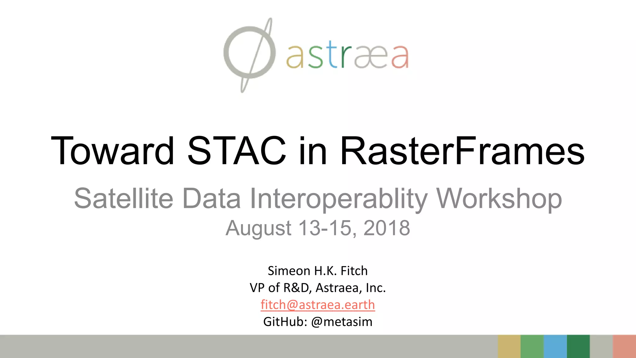
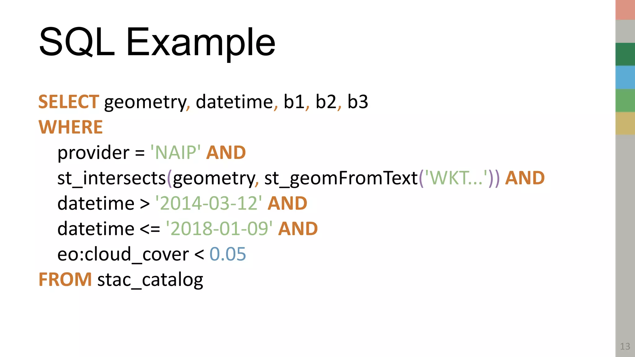
![SELECT geometry, datetime, b1, b2, b3
WHERE
provider = 'NAIP' AND
st_intersects(geometry, st_geomFromText('WKT...')) AND
datetime > '2014-03-12' AND
datetime <= '2018-01-09' AND
eo:cloud_cover < 0.05
FROM stac_catalog
RasterFrames: Canonical Query
5
λa
[0,0] λb
[0,0] λc
[0,0]TPEA
[0,0]
. . .
. . .TPEA
[0,1]
. . .
. . .
. . .. . .. . .. . .. . .
TPEA
[1,0]
TPEA
[1,1]
. . .. . .. . .. . .. . .
λa
[0,1] λb
[0,1] λc
[0,1]
λa
[1,0] λb
[1,0] λc
[1,0]
λc
[1,1]λb
[1,1]λa
[1,1]
SM[0,0]
SM[0,1]
SM[1,1]
SM[1,0]
. . .
. . .
Layer-wide Metadata](https://image.slidesharecdn.com/rasterframesstac-noanimations-180814211228/75/RasterFrames-STAC-5-2048.jpg)

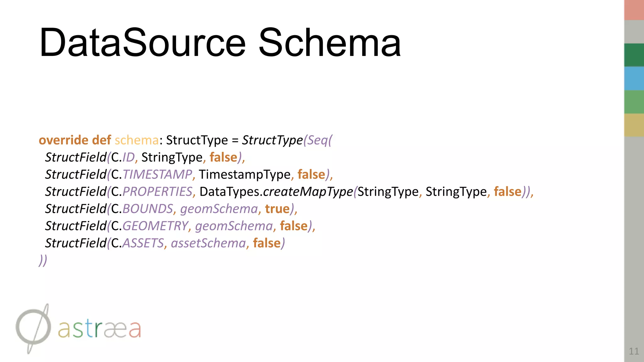
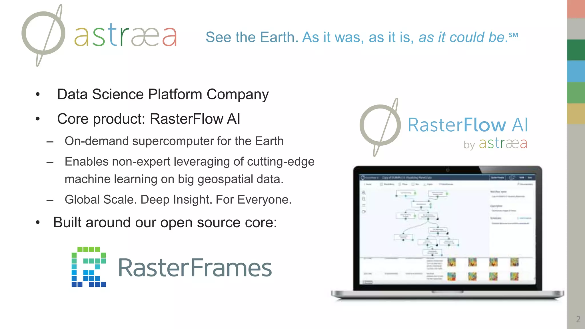
![DataSource Table Build
12
override def buildScan(requiredColumns: Array[String], attributeFilters: Array[Filter]): RDD[Row] = {
val activeFilters = filters ++ attributeFilters.filterNot(_.references.contains(C.TIMESTAMP))
/** If no filters are provided, were not going to return the whole catalog. */
if(filters.isEmpty) sqlContext.sparkContext.emptyRDD[Row]
else {
val query = STACRelation.toUrl(base, activeFilters)
val result = getJson(query)
val featureRDD = result.asJsObject.fields("features") match {
case JsArray(features) ⇒ sqlContext.sparkContext.makeRDD(features
case _ ⇒ throw new IllegalArgumentException("Unexpected JSON response recevied:n" + result)
}
featureRDD.map(_.convertTo[DOM.GeoJsonFeature]).map { feature ⇒
val entries = requiredColumns.map {
case C.ID ⇒ feature.properties(C.ID).convertTo[String]
case C.TIMESTAMP ⇒ feature.properties("datetime").convertTo[Timestamp]
case C.PROPERTIES ⇒ feature.properties.mapValues(_.toString)
case C.BOUNDS ⇒ feature.bbox.map(_.jtsGeom).orNull
case C.GEOMETRY ⇒ feature.geometry
case C.ASSETS ⇒ feature.assets.mapValues(_.toString)
}
Row(entries: _*)
}
}](https://image.slidesharecdn.com/rasterframesstac-noanimations-180814211228/75/RasterFrames-STAC-12-2048.jpg)

The document discusses integrating the SpatioTemporal Asset Catalog (STAC) specification with RasterFrames to enable querying geospatial raster data using SQL. It describes RasterFrames, an open source library that structures earth observation data in Spark DataFrames for machine learning applications. The document poses questions about using the STAC API for large-scale queries and streaming results, and integrating cloud-optimized geospatial (COG) formats.