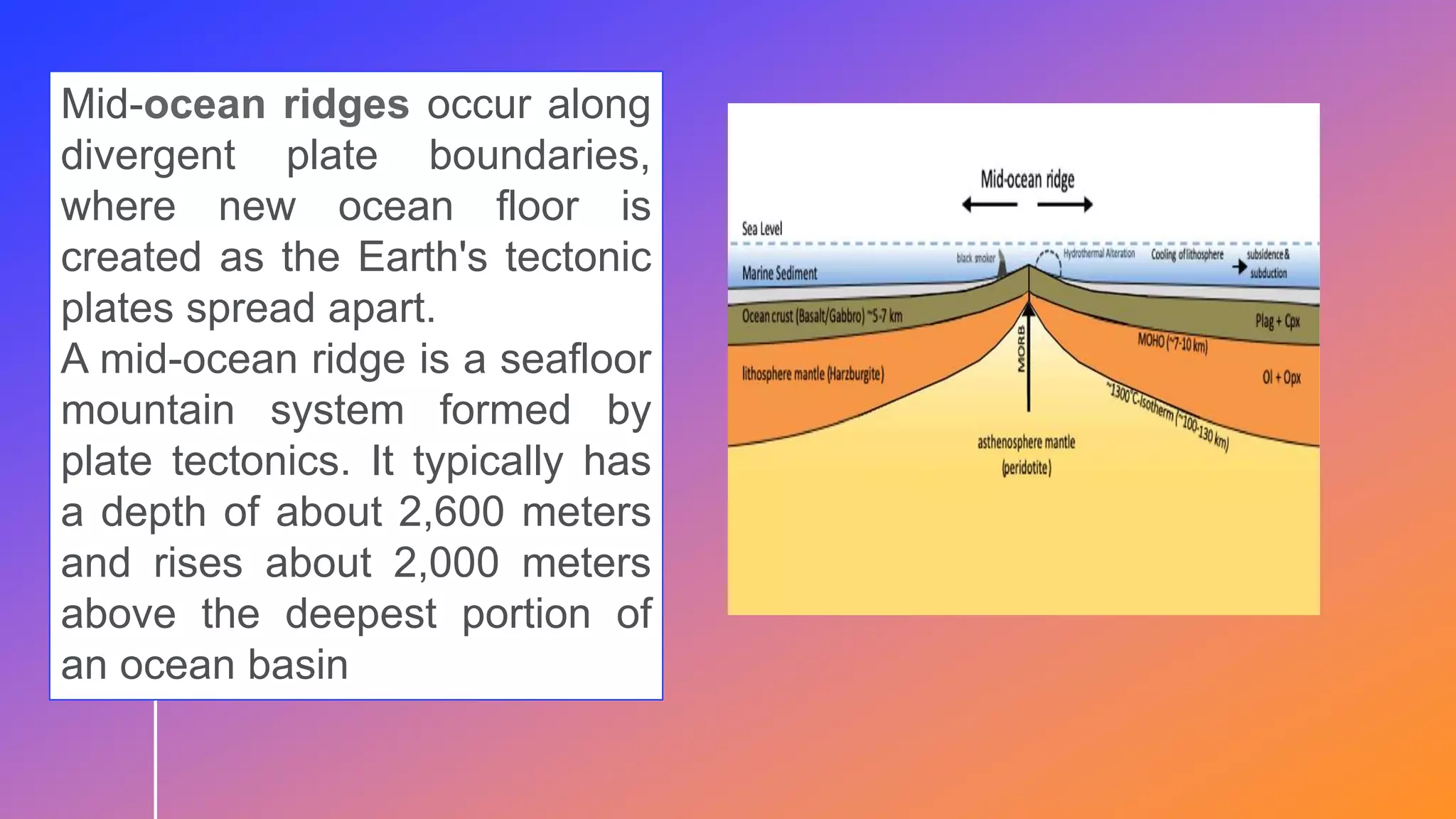
QUARTER 1 – LESSON 1:
DISTRIBUTION OF ACTIVE
VOLCANOES, EARTHQUAKES,
AND MOUNTAIN RANGES
Leiane Lei A. Luna
The Philippines is one of the countries in the world with high
disaster risk index. It means that we are vulnerable (IN DANGER)
to different natural hazards like storms, floods, and most of all
seismic activities. Several earthquakes occur everyday but most
are weak and generally cannot be felt by people.
The Philippines is an archipelago (A GROUP
OF ISLAND) blessed with beautiful natural
landforms that include dormant and active
volcanoes. Alongside with the aesthetics
value provided, however, is the high risk of
disaster. Earthquakes due to volcanic
activities are very common in the county. It is
likely that volcanoes are present in every
region.
Have you ever wondered why there are so many
volcanoes in the Philippines?
The lithosphere is the rocky
outer part of Earth. It is
made up of the brittle crust
and the top part of the upper
mantle. The lithosphere is the
coolest and most rigid part of
Earth
The Pacific Ring of Fire is a 40 000-kilometer, horseshoe-shaped
basin that is associated with oceanic trenches, volcanic arcs, and
plate movements. This ring includes several volcanoes from
southern tip of South America, up along the coast of North America,
across the Bering Strait, down through Japan, into New Zealand, and
even closed by several active and dormant volcanoes in Antarctica.
Around 75% of the world’s active and dormant volcanoes can be
found in this region.
Ring of Fire, also
called Circum-Pacific
Belt or Pacific Ring of
Fire, long horseshoe-
shaped seismically
active belt
of earthquake epicentre
s, volcanoes, and
tectonic plate
boundaries
that fringes the Pacific
basin.
Mid-ocean ridges occur along
divergent plate boundaries,
where new ocean floor is
created as the Earth's tectonic
plates spread apart.
A mid-ocean ridge is a seafloor
mountain system formed by
plate tectonics. It typically has
a depth of about 2,600 meters
and rises about 2,000 meters
above the deepest portion of
an ocean basin
What do you think is the
importance of determining the
epicenter of an earthquake?
Sesimologists use triangulation method to find the
epicenter of an earthquake. When seismic data is
collected from at least three different locations, it can
be used to determine the epicenter by where it
intersects.
Andes (SOUTH AMERICA)
Himalayas)
The Himalayas are the greatest mountain system
in Asia and one of the planet’s youngest mountain
ranges, that extends for more than 2,400km across the
nations of Bhutan, China, India, Nepal,
and Pakistan. ome of the highest peaks in the world are
located in the Himalayas, including Mount
Everest, Kangchenjunga, Lhotse, Makalu, Cho Oyu, etc.
It is believed that over the past 65 million
years, several worldwide plate-
tectonic events have led to the movement
of the Earth’s crust to form a vast number
of mountain ranges
There are mountain ranges closest to a certain
volcano.
Example, for Taal Volcano, they are Mount Macolod
(3107 ft.) which is 7 miles away from Taal, Mt.
Talamitan (2310 ft.), 17.3 miles away from Taal,
Mount Panay (1,644 ft.) 22.2 miles from Taal and
San Pablo Volcanic Field (3576 ft.) which is 22.2
miles away from Taal.
1. CARABALLO
MOUNTAINS
HIGHEST POINT: MOUNT
PALALI (1,707 METERS
OR 5,600 FEET ABOVE
SEA LEVEL)
The Caraballo Mountains, seen here with its chief peak and
highest point Mount Palali, remains one of the least-charted
mountain ranges of the Philippines; it is situated near the
middle part of Luzon
CORDILLERA CENTRAL
LENGTH: 320 KM (124 MI)
HIGHEST POINT: MOUNT
PULAG (2,922 M OR 9,587
FT ASL)
The Cordillera Central, more
commonly known as
the Cordilleras, is a
gigantic array of mountains
dominating the whole western
half of Northern Luzon. It is
the largest of all the
mountain ranges in the
Philippines, constituting
around a sixth of the entire
land area of Luzon.
Hamiguitan Mountain Range
HIGHEST POINT: Mount
Hamiguitan (1,620 m or 5,315 ft
ASL)
The Hamiguitan Mountain Range is
a narrow expanse of mountainous
upland stretched along the length of
the Pujada Peninsula, the strip of
land jutting out from the
southeastern coast of Mindanao and
forming the eastern bounds of the
Davao Gulf.
KALATUNGAN MOUNTAIN
RANGE
HIGHEST POINT: MOUNT
KALATUNGAN (2,860 M OR
9,283 FT ASL)
The Kalatungan Mountain Range is a closely-serried cluster of
mountains set in the midst of the province of Bukidnon, in Mindanao; it
lies immediately south of the slightly loftier Kitanglad Mountain Range,
and west of the far lengthier Pantaron Mountain Range.
CENTRAL PANAY
MOUNTAIN RANGE
LENGTH: 94 km (58 mi)
HIGHEST POINT: Mount
Madja-as (2,113 m or 6,932
ASL)
The Central Panay Mountain Range is stretched along the length of Panay
Island, in the Visayas group of islands. Despite its name, the range
is actually situated parallel to the western coast of the island,
arrayed from the Sibuyan Sea on the north to the Panay Gulf in the
south.
9/3/20XX PRESENTATION TITLE 35
9/3/20XX PRESENTATION TITLE 36
Learning Task 6
Earthquake prone areas in Luzon
Region 1
Ilocos Norte
Ilocos Sur
Region 2
Cagayan
Isabela
Nueva
Vizcaya
Quirino
Region 3
Aurora
Pampanga
Zambales
Region IV-A
Cavite
Laguna
Region V
Catanduanes
CAR
Abra
Benguet
9/3/20XX PRESENTATION TITLE 37
Learning Task 6
Earthquake prone areas in Visayas
Region VI
Antique
Iloilo
Region VII
Bohol
Region VIII
Eastern Samar
Leyte
Northern Samar
Southern Leyte
9/3/20XX PRESENTATION TITLE 38
Learning Task 6
Earthquake prone areas in Mindanao
Region IX
Isabela City
Region XIII
Dinagat Islands
Surigao Del Norte
Surigao Del Sur
Region X
Cagayan De Oro
9/3/20XX PRESENTATION TITLE 39
Learning Task 6
Active Volcanoes in Luzon
1. Babuyan Claro – Cagayan
2. Banahaw – Laguna & Quezon
3. Bulusan – Sorsogon, Bicol
4. Camiguin – Babuyan Island
5. Didicas & Cagua – Cagayan
6. Iraya – Batanes
7. Iriga & Isarog – Cam Sur
9/3/20XX PRESENTATION TITLE 40
Learning Task 6
Active Volcanoes in Visayas
1. Biliran – Leyte
2. Cabalian – Southern Leyte
3. Kanlaon – Negros Occidental &
Oriental
9/3/20XX PRESENTATION TITLE 41
Learning Task 6
Active Volcanoes in Mindanao
1. Bud Dajo – Sulu
2. Hibok-hibok – Camiguin
3. Matutum – Cotabato
4. Musuan – Bukidnon
5. Ragang – Lanao Del Sur
9/3/20XX PRESENTATION TITLE 42
Learning Task 6
Mountain Ranges in Luzon
1. Caraballo Mountains
2. Cordillera Central
3. Sierra Madre
4. Zambales Mountains
9/3/20XX PRESENTATION TITLE 43
Learning Task 6
Mountain Ranges in Mindanao
1. Kalantungan
2. Kitanglad
3. Pantaron
9/3/20XX PRESENTATION TITLE 44
Learning Task 6
Mountain Ranges in Visayas
1. Chocolate Hills
2. Mount Talinis
3. Mount Luho
LESSON: 5
PROCESSES THAT OCCUR
ALONG PLATE
BOUNDARIES
9/3/20XX 45
9/3/20XX 46
In the previous lesson you’ve learned about
the different types of plate boundaries,
oceanic-oceanic, continental-continental,
continental-oceanic convergent, divergent,
and transform plate boundaries and
determination of the locations of different
types of plate boundaries across the
continents.
This time, you will learn the different
processes and geologic features along
plate boundaries that slowly shaped the
Earth’s surface give rise to mountain
ranges, volcanoes, earthquake belts and
other geologic features for you
What is plate boundaries?
A plate boundary is a three-dimensional
surface or zone across which there is a
significant change in the velocity (speed or
direction) of motion of one lithospheric plate
relative to the adjacent lithospheric plate.
1.What process occurs along convergent
plate boundaries?
2. What geologic features formed when
two plates moved toward each other?
3. What are/is the reason/s why do
plates move toward each other
Subduction is a geological process in which the oceanic
lithosphere is recycled into the Earth's mantle
at convergent boundaries. Where the oceanic lithosphere
of a tectonic plate converges with the less dense
lithosphere of a second plate, the heavier plate dives
beneath the second plate and sinks into the mantle.
Subduction zone is a spot where two of
the tectonic plates collide and one dives,
or subducts, beneath the other.
Seafloor spreading occurs at divergent plate boundaries. As
tectonic plates slowly move away from each other, heat from
the mantle's convection currents makes the crust more plastic
and less dense. The less-dense material rises, often forming a
mountain or elevated area of the seafloor. Eventually, the crust
cracks.
A divergent boundary occurs when two tectonic plates
move away from each other. Along these
boundaries, earthquakes are common and magma
(molten rock) rises from the Earth's mantle to the surface,
solidifying to create new oceanic crust.
If the divergent movement is happening in the oceanic
plates, it can lead to the formation of an OCEANIC RIDGE
and RIFT VALLEY
What are Oceanic Ridge and Rift
Valley? How are they form?
A rift valley is a lowland region that forms where
Earth’s tectonic plates move apart,
or rift. Rift valleys are found both on land and at the
bottom of the ocean, where they are created by the
process of seafloor spreading.
An oceanic basin is the land
surface under an ocean that
includes the various
topography below the water
Ocean basin is formed when
water has covered a large
portion of the Earth’s crust
Famous Oceanic Basins
• Atlantic Ocean Basin
• Indian Ocean Basin
• Arctic Ocean Basin
• Pacific Ocean Basin
Transform-fault boundaries are
also called conservative
boundaries because crust is
neither destroyed or created
along them.
Most are common on the
seafloor where they form
oceanic fracture zones. When
they occur on land they produce
FAULTS.
No leading edge of plate is
being destroyed, this means
that no volcanoes, no mountains
are form but rather
EARTHQUAKE.
Most transform faults are located
within the ocean basins, there are a
few that cuts through the continental
crust like the San Andreas fault.
ACTIVITY : LET’S BE CONNECTED!
ASSEMBLE THE CONTINENTS
TO SHOW
SUPERCONTINENT PANGEA
LESSON 7:
OBJECTIVES:
Introduction:
In this lesson, you will able you to evaluate the
different theories explaining the possible causes
of tectonic plates, understand the convection
current and importance of tectonic plates to the
survival of earth and its inhabitants. It will also
help you to describe the possible causes of plate
movement and explain these causes.
This word is a noun and comes from
the Greek theoria, which means
"contemplation or speculation."
A set of beliefs or
principles that might
not be proven yet.
Study the comic strip .
What did you notice? What
are they telling about each
other ?
The forces that drive Plate Tectonics include:
•Convection in the Mantle (heat driven)
•Ridge push (gravitational force at the
spreading ridges)
•Slab pull (gravitational force in subduction
zones)
Convection in the Mantle
- warm mantle
currents drive and
carry plates of
lithosphere along a
like a conveyor
belt;
Ridge Push It occurs at the mid ocean ridges.
(also known as gravitational
sliding) or sliding plate force is a
proposed driving force for plate
motion in plate tectonics that
occurs at mid-ocean ridges as the
result of the
rigid lithosphere sliding down the
hot, raised asthenosphere
below mid-ocean ridges.
Slab Pull The weight of the subducting plate
pulls the trailing slab into the
subduction zone
at destructive plate margins the
denser, oceanic plate sinks into the
mantle under the influence of gravity,
which pulls the rest of the plate along
with it. This is known as slab pull.
Convection currents, ridge
push and slab pull are
believed to be responsible for
tectonic plate movement
Convection in the Mantle
Continuous loop of
sinking hot soft rocks
caused by energy
transferred in the
Asthenosphere (Earth’s
mantle)
Convection in the Mantle
• Hot water rises
• Cooler water sinks
 Sinking of cold and warm
materials in the mantle.
Quarter 1 – LESSON 1 SCIENCE 10.pptx

Quarter 1 – LESSON 1 SCIENCE 10.pptx

  • 1.
    QUARTER 1 –LESSON 1: DISTRIBUTION OF ACTIVE VOLCANOES, EARTHQUAKES, AND MOUNTAIN RANGES Leiane Lei A. Luna
  • 4.
    The Philippines isone of the countries in the world with high disaster risk index. It means that we are vulnerable (IN DANGER) to different natural hazards like storms, floods, and most of all seismic activities. Several earthquakes occur everyday but most are weak and generally cannot be felt by people.
  • 5.
    The Philippines isan archipelago (A GROUP OF ISLAND) blessed with beautiful natural landforms that include dormant and active volcanoes. Alongside with the aesthetics value provided, however, is the high risk of disaster. Earthquakes due to volcanic activities are very common in the county. It is likely that volcanoes are present in every region. Have you ever wondered why there are so many volcanoes in the Philippines?
  • 8.
    The lithosphere isthe rocky outer part of Earth. It is made up of the brittle crust and the top part of the upper mantle. The lithosphere is the coolest and most rigid part of Earth
  • 14.
    The Pacific Ringof Fire is a 40 000-kilometer, horseshoe-shaped basin that is associated with oceanic trenches, volcanic arcs, and plate movements. This ring includes several volcanoes from southern tip of South America, up along the coast of North America, across the Bering Strait, down through Japan, into New Zealand, and even closed by several active and dormant volcanoes in Antarctica. Around 75% of the world’s active and dormant volcanoes can be found in this region.
  • 15.
    Ring of Fire,also called Circum-Pacific Belt or Pacific Ring of Fire, long horseshoe- shaped seismically active belt of earthquake epicentre s, volcanoes, and tectonic plate boundaries that fringes the Pacific basin.
  • 17.
    Mid-ocean ridges occuralong divergent plate boundaries, where new ocean floor is created as the Earth's tectonic plates spread apart. A mid-ocean ridge is a seafloor mountain system formed by plate tectonics. It typically has a depth of about 2,600 meters and rises about 2,000 meters above the deepest portion of an ocean basin
  • 19.
    What do youthink is the importance of determining the epicenter of an earthquake?
  • 20.
    Sesimologists use triangulationmethod to find the epicenter of an earthquake. When seismic data is collected from at least three different locations, it can be used to determine the epicenter by where it intersects.
  • 25.
  • 26.
    Himalayas) The Himalayas arethe greatest mountain system in Asia and one of the planet’s youngest mountain ranges, that extends for more than 2,400km across the nations of Bhutan, China, India, Nepal, and Pakistan. ome of the highest peaks in the world are located in the Himalayas, including Mount Everest, Kangchenjunga, Lhotse, Makalu, Cho Oyu, etc. It is believed that over the past 65 million years, several worldwide plate- tectonic events have led to the movement of the Earth’s crust to form a vast number of mountain ranges
  • 30.
    There are mountainranges closest to a certain volcano. Example, for Taal Volcano, they are Mount Macolod (3107 ft.) which is 7 miles away from Taal, Mt. Talamitan (2310 ft.), 17.3 miles away from Taal, Mount Panay (1,644 ft.) 22.2 miles from Taal and San Pablo Volcanic Field (3576 ft.) which is 22.2 miles away from Taal.
  • 31.
    1. CARABALLO MOUNTAINS HIGHEST POINT:MOUNT PALALI (1,707 METERS OR 5,600 FEET ABOVE SEA LEVEL) The Caraballo Mountains, seen here with its chief peak and highest point Mount Palali, remains one of the least-charted mountain ranges of the Philippines; it is situated near the middle part of Luzon
  • 32.
    CORDILLERA CENTRAL LENGTH: 320KM (124 MI) HIGHEST POINT: MOUNT PULAG (2,922 M OR 9,587 FT ASL) The Cordillera Central, more commonly known as the Cordilleras, is a gigantic array of mountains dominating the whole western half of Northern Luzon. It is the largest of all the mountain ranges in the Philippines, constituting around a sixth of the entire land area of Luzon.
  • 33.
    Hamiguitan Mountain Range HIGHESTPOINT: Mount Hamiguitan (1,620 m or 5,315 ft ASL) The Hamiguitan Mountain Range is a narrow expanse of mountainous upland stretched along the length of the Pujada Peninsula, the strip of land jutting out from the southeastern coast of Mindanao and forming the eastern bounds of the Davao Gulf.
  • 34.
    KALATUNGAN MOUNTAIN RANGE HIGHEST POINT:MOUNT KALATUNGAN (2,860 M OR 9,283 FT ASL) The Kalatungan Mountain Range is a closely-serried cluster of mountains set in the midst of the province of Bukidnon, in Mindanao; it lies immediately south of the slightly loftier Kitanglad Mountain Range, and west of the far lengthier Pantaron Mountain Range.
  • 35.
    CENTRAL PANAY MOUNTAIN RANGE LENGTH:94 km (58 mi) HIGHEST POINT: Mount Madja-as (2,113 m or 6,932 ASL) The Central Panay Mountain Range is stretched along the length of Panay Island, in the Visayas group of islands. Despite its name, the range is actually situated parallel to the western coast of the island, arrayed from the Sibuyan Sea on the north to the Panay Gulf in the south. 9/3/20XX PRESENTATION TITLE 35
  • 36.
    9/3/20XX PRESENTATION TITLE36 Learning Task 6 Earthquake prone areas in Luzon Region 1 Ilocos Norte Ilocos Sur Region 2 Cagayan Isabela Nueva Vizcaya Quirino Region 3 Aurora Pampanga Zambales Region IV-A Cavite Laguna Region V Catanduanes CAR Abra Benguet
  • 37.
    9/3/20XX PRESENTATION TITLE37 Learning Task 6 Earthquake prone areas in Visayas Region VI Antique Iloilo Region VII Bohol Region VIII Eastern Samar Leyte Northern Samar Southern Leyte
  • 38.
    9/3/20XX PRESENTATION TITLE38 Learning Task 6 Earthquake prone areas in Mindanao Region IX Isabela City Region XIII Dinagat Islands Surigao Del Norte Surigao Del Sur Region X Cagayan De Oro
  • 39.
    9/3/20XX PRESENTATION TITLE39 Learning Task 6 Active Volcanoes in Luzon 1. Babuyan Claro – Cagayan 2. Banahaw – Laguna & Quezon 3. Bulusan – Sorsogon, Bicol 4. Camiguin – Babuyan Island 5. Didicas & Cagua – Cagayan 6. Iraya – Batanes 7. Iriga & Isarog – Cam Sur
  • 40.
    9/3/20XX PRESENTATION TITLE40 Learning Task 6 Active Volcanoes in Visayas 1. Biliran – Leyte 2. Cabalian – Southern Leyte 3. Kanlaon – Negros Occidental & Oriental
  • 41.
    9/3/20XX PRESENTATION TITLE41 Learning Task 6 Active Volcanoes in Mindanao 1. Bud Dajo – Sulu 2. Hibok-hibok – Camiguin 3. Matutum – Cotabato 4. Musuan – Bukidnon 5. Ragang – Lanao Del Sur
  • 42.
    9/3/20XX PRESENTATION TITLE42 Learning Task 6 Mountain Ranges in Luzon 1. Caraballo Mountains 2. Cordillera Central 3. Sierra Madre 4. Zambales Mountains
  • 43.
    9/3/20XX PRESENTATION TITLE43 Learning Task 6 Mountain Ranges in Mindanao 1. Kalantungan 2. Kitanglad 3. Pantaron
  • 44.
    9/3/20XX PRESENTATION TITLE44 Learning Task 6 Mountain Ranges in Visayas 1. Chocolate Hills 2. Mount Talinis 3. Mount Luho
  • 45.
    LESSON: 5 PROCESSES THATOCCUR ALONG PLATE BOUNDARIES 9/3/20XX 45
  • 46.
    9/3/20XX 46 In theprevious lesson you’ve learned about the different types of plate boundaries, oceanic-oceanic, continental-continental, continental-oceanic convergent, divergent, and transform plate boundaries and determination of the locations of different types of plate boundaries across the continents.
  • 47.
    This time, youwill learn the different processes and geologic features along plate boundaries that slowly shaped the Earth’s surface give rise to mountain ranges, volcanoes, earthquake belts and other geologic features for you
  • 48.
    What is plateboundaries? A plate boundary is a three-dimensional surface or zone across which there is a significant change in the velocity (speed or direction) of motion of one lithospheric plate relative to the adjacent lithospheric plate.
  • 49.
    1.What process occursalong convergent plate boundaries? 2. What geologic features formed when two plates moved toward each other? 3. What are/is the reason/s why do plates move toward each other
  • 50.
    Subduction is ageological process in which the oceanic lithosphere is recycled into the Earth's mantle at convergent boundaries. Where the oceanic lithosphere of a tectonic plate converges with the less dense lithosphere of a second plate, the heavier plate dives beneath the second plate and sinks into the mantle.
  • 51.
    Subduction zone isa spot where two of the tectonic plates collide and one dives, or subducts, beneath the other.
  • 53.
    Seafloor spreading occursat divergent plate boundaries. As tectonic plates slowly move away from each other, heat from the mantle's convection currents makes the crust more plastic and less dense. The less-dense material rises, often forming a mountain or elevated area of the seafloor. Eventually, the crust cracks.
  • 54.
    A divergent boundaryoccurs when two tectonic plates move away from each other. Along these boundaries, earthquakes are common and magma (molten rock) rises from the Earth's mantle to the surface, solidifying to create new oceanic crust.
  • 55.
    If the divergentmovement is happening in the oceanic plates, it can lead to the formation of an OCEANIC RIDGE and RIFT VALLEY
  • 56.
    What are OceanicRidge and Rift Valley? How are they form?
  • 60.
    A rift valleyis a lowland region that forms where Earth’s tectonic plates move apart, or rift. Rift valleys are found both on land and at the bottom of the ocean, where they are created by the process of seafloor spreading.
  • 62.
    An oceanic basinis the land surface under an ocean that includes the various topography below the water Ocean basin is formed when water has covered a large portion of the Earth’s crust Famous Oceanic Basins • Atlantic Ocean Basin • Indian Ocean Basin • Arctic Ocean Basin • Pacific Ocean Basin
  • 64.
    Transform-fault boundaries are alsocalled conservative boundaries because crust is neither destroyed or created along them. Most are common on the seafloor where they form oceanic fracture zones. When they occur on land they produce FAULTS. No leading edge of plate is being destroyed, this means that no volcanoes, no mountains are form but rather EARTHQUAKE.
  • 65.
    Most transform faultsare located within the ocean basins, there are a few that cuts through the continental crust like the San Andreas fault.
  • 66.
    ACTIVITY : LET’SBE CONNECTED! ASSEMBLE THE CONTINENTS TO SHOW SUPERCONTINENT PANGEA
  • 68.
  • 69.
  • 70.
    Introduction: In this lesson,you will able you to evaluate the different theories explaining the possible causes of tectonic plates, understand the convection current and importance of tectonic plates to the survival of earth and its inhabitants. It will also help you to describe the possible causes of plate movement and explain these causes.
  • 71.
    This word isa noun and comes from the Greek theoria, which means "contemplation or speculation." A set of beliefs or principles that might not be proven yet.
  • 72.
    Study the comicstrip . What did you notice? What are they telling about each other ?
  • 73.
    The forces thatdrive Plate Tectonics include: •Convection in the Mantle (heat driven) •Ridge push (gravitational force at the spreading ridges) •Slab pull (gravitational force in subduction zones)
  • 74.
    Convection in theMantle - warm mantle currents drive and carry plates of lithosphere along a like a conveyor belt;
  • 75.
    Ridge Push Itoccurs at the mid ocean ridges. (also known as gravitational sliding) or sliding plate force is a proposed driving force for plate motion in plate tectonics that occurs at mid-ocean ridges as the result of the rigid lithosphere sliding down the hot, raised asthenosphere below mid-ocean ridges.
  • 76.
    Slab Pull Theweight of the subducting plate pulls the trailing slab into the subduction zone at destructive plate margins the denser, oceanic plate sinks into the mantle under the influence of gravity, which pulls the rest of the plate along with it. This is known as slab pull.
  • 77.
    Convection currents, ridge pushand slab pull are believed to be responsible for tectonic plate movement
  • 78.
    Convection in theMantle Continuous loop of sinking hot soft rocks caused by energy transferred in the Asthenosphere (Earth’s mantle)
  • 79.
    Convection in theMantle • Hot water rises • Cooler water sinks  Sinking of cold and warm materials in the mantle.

Editor's Notes

  • #4 How many words do you remember?
  • #5 Our country is part of the Pacific Ring of Fire. Thus, we often experience earthquakes, and we are home to many majestic but terrible volcanoes.
  • #6 Read and study the picture. Observe the location of active volcanoes in the Philippines ? Can you locate them in the map?
  • #7 What is the role of landforms in the community and our environment? Major sources of our basic necessity foods, clothes and shelter Gives protection to from calamities like typhoon Provide livelihood specially the agricultural
  • #8 The landforms are form at the earth’s crust 1.The oceanic crust is thinner while the continental crust is much thicker. 2. The oceanic crust is denser than the continental crust.
  • #9 The landforms are form at the earth’s crust 1.The oceanic crust is thinner while the continental crust is much thicker. 2. The oceanic crust is denser than the continental crust.
  • #10 Now let us learn the major geologic features and landforms in the earth crust
  • #11 Because our country is located at the pacific ring of fire
  • #12 Because our country is located at the pacific ring of fire
  • #13 Because our country is located at the pacific ring of fire
  • #14 How about the active volcanoes in the world ?? If we are going to plot the active volcanoes in the world we were able to locate a chain of volcanoes……………..
  • #15 Because our country is located at the pacific ring of fire
  • #17 Because our country is located at the pacific ring of fire
  • #19 The second geologic features The focus is the place inside Earth's crust where an earthquake originates. The point on the Earth's surface directly above the focus is the epicenter. Originally earthquakes begin or originate at Earth’s interior.
  • #20 The second geologic features The focus is the place inside Earth's crust where an earthquake originates. The point on the Earth's surface directly above the focus is the epicenter. Originally earthquakes begin or originate at Earth’s interior.
  • #23 Let’s spot the epicenter during the past occurrences
  • #24 If we compared they are in the same location
  • #25 The next geologic features
  • #28 Because our country is located at the pacific ring of fire
  • #30 COMPARING THE DISTRIBUTION OF THIS GEOLOGIC FEATURES AND LANDFORMS
  • #31 Can you name the mountain ranges of other active volcanoes in the country ?
  • #49 Earth resembles a giant jigsaw puzzle. That is because its outer surface is composed of about 20 tectonic plates, enormous sections of Earth’s crust that roughly fit together and meet at places called plate boundaries.
  • #56 Between two oceanic plates the creation of mid-ocean ridge
  • #57 The oceanic ridge occurs when convection currents rise in the mantle beneath the oceanic crust and create magma where two tectonic plates meet at a divergent boundary.
  • #61 Many of Earth’s deepest rift valleys are found underwater During the two continental convergence rift valley and new ocean basin are formed
  • #62 Great Rift Valley The most well-known rift valley on Earth is probably the so-called "Great Rift Valley System" which stretches from the Middle East in the north to Mozambique in the south. The area is geologically active, and features volcanoes, hot springs, geysers, and frequent earthquakes. 
  • #65 They are also called conservative boundaries because crust is neither destroyed or created along them. What process occurs along transform fault plate boundary? The grinding action between the plates at a transform plate boundary
  • #76 Newly-formed plates at oceanic ridges (constructive plate margins) are warm, and so have a higher elevation at the oceanic ridge than the colder, more dense plate material further away; gravity causes the higher plate at the ridge to push away causing the plates to move away from each other.
  • #79 Sinking of cold and warm materials in the mantle.
  • #80 Sinking of cold and warm materials in the mantle.