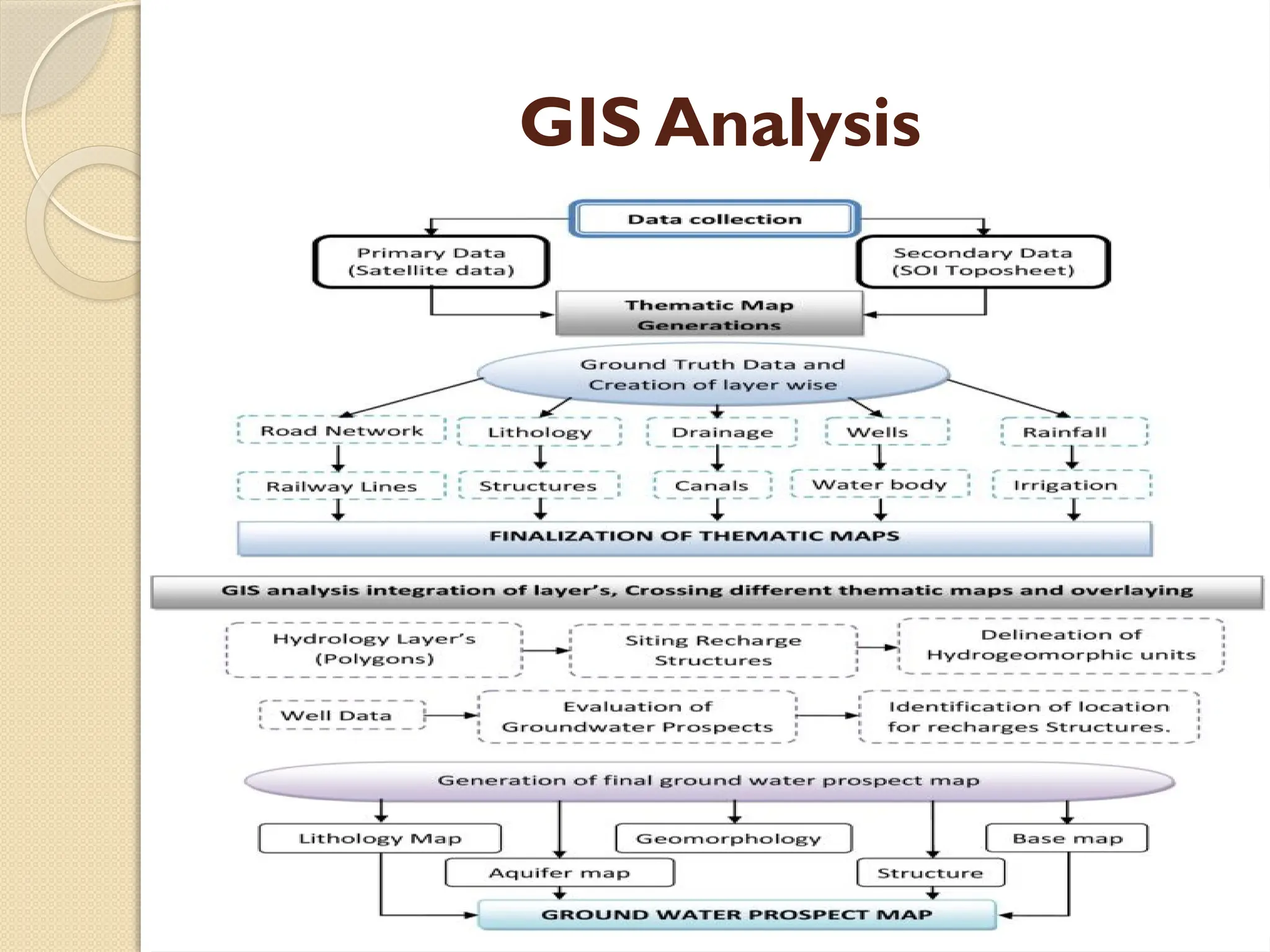
Rajkiya Engineering College Kannauj
 APPLICATION OF REMOTE SENSING AND GIS IN WATER
PROSPECTING
Under The supervision of : Presented by :
Rishabh kashyap Kushagra Sharma (16)
CO supervisor : Arvind Kumar (07)
Abhishek Patel
Table Of Content
(i) Introduction
(ii) Why remote sensing for groundwater
(iii) How Remote Sensing Works
(iv) Applications in Groundwater Prospecting
(v) Key Remote Sensing Techniques
(vi) Integration with GIS
(vii) GIS Analysis
(viii) Conclusion
(ix) Future Exploration
INTRODUCTION
Remote sensing is the process of
obtaining information about an object or
phenomenon without direct physical
contact. In the context of groundwater
prospecting, it involves collecting data
about the Earth's surface and subsurface
from a distance, typically using satellites
or aircraft.
How Remote Sensing Works
 Satellite and SensorTechnology:
Remote sensing utilizes various sensors on
satellites or aircraft to capture electromagnetic
radiation reflected or emitted by the Earth's
surface.
 DataTransmission and Processing:
Once collected, the data is transmitted to
ground stations and processed using specialized
software.This processed information can then
be analyzed to extract valuable insights.
Why Remote sensing for
groundwater
 Remote sensing is a valuable tool for
groundwater exploration and management due
to its ability to provide comprehensive and non-
invasive information about the Earth's surface
and subsurface . Some reason are
 Large-Scale Coverage
 Efficient Data Collection
 Identification of Surface Water Bodies
 Integration with Geographic Information
System (GIS
Applications in Groundwater Prospecting
 Surface Water Mapping:
◦ Remote sensing can be used to identify
surface water bodies, helping to understand
their distribution and dynamics.
 Subsurface Water Detection:
◦ Thermal infrared imaging and other
techniques enable the detection of
subsurface water, assisting in locating
potential groundwater sources.
Key Remote SensingTechniques
 Satellite Imagery:
◦ High-resolution satellite imagery provides detailed
visual information about the Earth's surface, aiding
in geological and hydrological studies.
 Thermal Infrared Imaging:
◦ Measures temperature differences to identify
areas where groundwater is likely present.
 Radar and LiDAR:
◦ Radar technology penetrates the Earth's surface,
allowing for subsurface imaging, while LiDAR
provides detailed elevation data.
Integration with GIS
 Geographic Information System
Remote sensing data is often integrated
into GIS for spatial analysis. GIS allows for
the overlay of multiple layers of
information, aiding in the identification of
potential groundwater zones.
GIS Analysis
Conclusion
 Summary:
◦ In summary, remote sensing offers a
powerful and efficient tool for
groundwater prospecting, providing
valuable insights into surface and
subsurface features.
Future Exploration
◦ As technology advances, the integration
of remote sensing with other geospatial
technologies promises even more
accurate and detailed information for
sustainable water management.
THANKYOU

ppt for mini project[1].pptx of application of remote sensing

  • 1.
    Rajkiya Engineering CollegeKannauj  APPLICATION OF REMOTE SENSING AND GIS IN WATER PROSPECTING Under The supervision of : Presented by : Rishabh kashyap Kushagra Sharma (16) CO supervisor : Arvind Kumar (07) Abhishek Patel
  • 2.
    Table Of Content (i)Introduction (ii) Why remote sensing for groundwater (iii) How Remote Sensing Works (iv) Applications in Groundwater Prospecting (v) Key Remote Sensing Techniques (vi) Integration with GIS (vii) GIS Analysis (viii) Conclusion (ix) Future Exploration
  • 3.
    INTRODUCTION Remote sensing isthe process of obtaining information about an object or phenomenon without direct physical contact. In the context of groundwater prospecting, it involves collecting data about the Earth's surface and subsurface from a distance, typically using satellites or aircraft.
  • 4.
    How Remote SensingWorks  Satellite and SensorTechnology: Remote sensing utilizes various sensors on satellites or aircraft to capture electromagnetic radiation reflected or emitted by the Earth's surface.  DataTransmission and Processing: Once collected, the data is transmitted to ground stations and processed using specialized software.This processed information can then be analyzed to extract valuable insights.
  • 5.
    Why Remote sensingfor groundwater  Remote sensing is a valuable tool for groundwater exploration and management due to its ability to provide comprehensive and non- invasive information about the Earth's surface and subsurface . Some reason are  Large-Scale Coverage  Efficient Data Collection  Identification of Surface Water Bodies  Integration with Geographic Information System (GIS
  • 6.
    Applications in GroundwaterProspecting  Surface Water Mapping: ◦ Remote sensing can be used to identify surface water bodies, helping to understand their distribution and dynamics.  Subsurface Water Detection: ◦ Thermal infrared imaging and other techniques enable the detection of subsurface water, assisting in locating potential groundwater sources.
  • 7.
    Key Remote SensingTechniques Satellite Imagery: ◦ High-resolution satellite imagery provides detailed visual information about the Earth's surface, aiding in geological and hydrological studies.  Thermal Infrared Imaging: ◦ Measures temperature differences to identify areas where groundwater is likely present.  Radar and LiDAR: ◦ Radar technology penetrates the Earth's surface, allowing for subsurface imaging, while LiDAR provides detailed elevation data.
  • 8.
    Integration with GIS Geographic Information System Remote sensing data is often integrated into GIS for spatial analysis. GIS allows for the overlay of multiple layers of information, aiding in the identification of potential groundwater zones.
  • 9.
  • 10.
    Conclusion  Summary: ◦ Insummary, remote sensing offers a powerful and efficient tool for groundwater prospecting, providing valuable insights into surface and subsurface features.
  • 11.
    Future Exploration ◦ Astechnology advances, the integration of remote sensing with other geospatial technologies promises even more accurate and detailed information for sustainable water management.
  • 12.