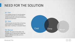
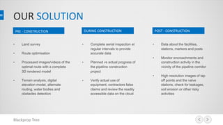
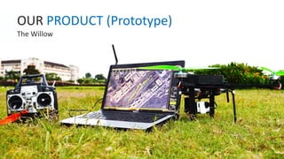
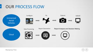
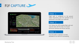
Using Unmanned Aerial Vehicles
Pipeline Inspection Services
NEED FOR THE SOLUTION
Blackprop Tree
01. Cost
The existing process of manual pipeline
inspection during the pre-construction,
during construction and post-construction
phases are expensive
02. Time
The processes are also time consuming
and involves lot of dependencies on
each other, resulting in unwanted delays
03. Manual
Besides, the cost and time factor, the
complete set of manual work makes the
project inefficient and often prone to
manual errors
Cost Time Manual
OUR SOLUTION
Blackprop Tree
• Land survey
• Route optimisation
• Processed images/videos of the
optimal route with a complete
3D rendered model
• Terrain analysis, digital
elevation model, alternate
routing, water bodies and
obstacles detection
PRE - CONSTRUCTION DURING CONSTRUCTION POST - CONSTRUCTION
• Complete aerial inspection at
regular intervals to provide
accurate data
• Planned vs actual progress of
the pipeline construction
project
• Verify actual use of
equipment, contractors false
claims and review the readily
accessible data on the cloud
• Data about the facilities,
stations, markers and posts
• Monitor encroachments and
construction activity in the
vicinity of the pipeline corridor
• High resolution images of tap
off points and the valve
stations, check for leakages,
soil erosion or other risky
activities
OUR PRODUCT (Prototype)
The Willow
PRODUCT OVERVIEW
Range of 25 km radius
VOTL: Automatic vertical takeoff and landing incorporating waypoint-navigation using GPS.
Hovering: Stable hovering over a particular point for prolonged attention to a single point for up to 50 minutes in a single point and touch
operation
Very Easy to use: Compared to other UAVs, our product requires next to no training to operate. Our custom made Willow flight suit
software makes flying the UAV as simple as playing a computer game
Fail Safe Features : In case of low battery, signal/GPS Failure, Onboard failures or obstacles, UAV will automatically return to its takeoff
point and/or land
Night Vision Enabled Camera with zoom and user controlled 360 degree pan to focus in any direction
Blackprop Tree
OUR PROCESS FLOW
Blackprop Tree
Unmanned
Aerial
Vehicles
Cloud
Fly Capture UploadConfigure
Data Processing Report Analysis and Decision MakingReport Generation
FLY CAPTURE
Blackprop Tree
STAGE - 1
Flight path is configured on the ground
station depending upon the operation to be
performed or the data to be captured
STAGE - 2
UAV follows the GPS enabled flight path and
captures data with the help of on board
advanced cameras and sensor devices
STAGE - 3
Once the data is captured, it is then
uploaded to our server for processing
PROCESS ON CLOUD
Blackprop Tree
We use the most advanced software systems for processing high quality data, in no time. The fully encrypted data is
accessible to all the authorized employees in your organization, anywhere and anytime.
REPORTS
Automated custom built reports are generated as
per the clients requirements. Decisions can now be
made quicker based on these reports
LAYERISATION
Multiple layers are applied on this processed data
and different models are created, as per the clients
requirement. Custom objects are built with “one
click” option to apply filters and access this data
PROCESS
The uploaded data is automatically processed for
initial stitching and rendering
ON GROUND
Highly efficient, safe and advanced, small sized unmanned aircrafts which travel long distances at a good speed and scans the
pipeline corridor. Our trained ground staff ensures smooth process management, at the ground level, and operates the UAVs
Blackprop Tree
DELIVERABLES
Blackprop Tree
Our UAVs scans the areas of interest and provides
Complete land survey reports along with the route
planning and optimization
Blackprop Tree
Get a digital elevation map of the
planned route to further analyse the
feasibility of the complete route
Generate stitched images to get a high quality
data upto 2 cm/pixel and detect various
obstacles like river, buildings, highways, cities
Obstacles Detection Digital Elevation Map
OUR ADVANTAGES
Blackprop Tree
We just don’t build drones and fly, we
actually make sure every flight is
meaningful for our customers, with the
most accurate data they can get
Experience in executing
similar projects and
providing great customer
satisfaction
Integrated platform for
delivering professional
services as per the client
requirements
We
Build
Uses the most cutting edge
technologies for building
the UAV, Data Collection
and Data Processing
Innovative Data Services
We
Deliver
We
Execute
CONTACT DETAILS
Blackprop Tree
Room #4, Student Technology
Business Incubation Center,
BITS Pialni, Goa - 403726
www.blackproptree.in
dhilbar@blackproptree.in
+91-9561687802
ADDRESS:
WEBSITE:
EMAIL:
TELEPHONE:

Petroleum Pipeline Inspection using UAVs

  • 1.
    Using Unmanned AerialVehicles Pipeline Inspection Services
  • 2.
    NEED FOR THESOLUTION Blackprop Tree 01. Cost The existing process of manual pipeline inspection during the pre-construction, during construction and post-construction phases are expensive 02. Time The processes are also time consuming and involves lot of dependencies on each other, resulting in unwanted delays 03. Manual Besides, the cost and time factor, the complete set of manual work makes the project inefficient and often prone to manual errors Cost Time Manual
  • 3.
    OUR SOLUTION Blackprop Tree •Land survey • Route optimisation • Processed images/videos of the optimal route with a complete 3D rendered model • Terrain analysis, digital elevation model, alternate routing, water bodies and obstacles detection PRE - CONSTRUCTION DURING CONSTRUCTION POST - CONSTRUCTION • Complete aerial inspection at regular intervals to provide accurate data • Planned vs actual progress of the pipeline construction project • Verify actual use of equipment, contractors false claims and review the readily accessible data on the cloud • Data about the facilities, stations, markers and posts • Monitor encroachments and construction activity in the vicinity of the pipeline corridor • High resolution images of tap off points and the valve stations, check for leakages, soil erosion or other risky activities
  • 4.
  • 5.
    PRODUCT OVERVIEW Range of25 km radius VOTL: Automatic vertical takeoff and landing incorporating waypoint-navigation using GPS. Hovering: Stable hovering over a particular point for prolonged attention to a single point for up to 50 minutes in a single point and touch operation Very Easy to use: Compared to other UAVs, our product requires next to no training to operate. Our custom made Willow flight suit software makes flying the UAV as simple as playing a computer game Fail Safe Features : In case of low battery, signal/GPS Failure, Onboard failures or obstacles, UAV will automatically return to its takeoff point and/or land Night Vision Enabled Camera with zoom and user controlled 360 degree pan to focus in any direction Blackprop Tree
  • 6.
    OUR PROCESS FLOW BlackpropTree Unmanned Aerial Vehicles Cloud Fly Capture UploadConfigure Data Processing Report Analysis and Decision MakingReport Generation
  • 7.
    FLY CAPTURE Blackprop Tree STAGE- 1 Flight path is configured on the ground station depending upon the operation to be performed or the data to be captured STAGE - 2 UAV follows the GPS enabled flight path and captures data with the help of on board advanced cameras and sensor devices STAGE - 3 Once the data is captured, it is then uploaded to our server for processing
  • 8.
    PROCESS ON CLOUD BlackpropTree We use the most advanced software systems for processing high quality data, in no time. The fully encrypted data is accessible to all the authorized employees in your organization, anywhere and anytime. REPORTS Automated custom built reports are generated as per the clients requirements. Decisions can now be made quicker based on these reports LAYERISATION Multiple layers are applied on this processed data and different models are created, as per the clients requirement. Custom objects are built with “one click” option to apply filters and access this data PROCESS The uploaded data is automatically processed for initial stitching and rendering
  • 9.
    ON GROUND Highly efficient,safe and advanced, small sized unmanned aircrafts which travel long distances at a good speed and scans the pipeline corridor. Our trained ground staff ensures smooth process management, at the ground level, and operates the UAVs Blackprop Tree
  • 10.
    DELIVERABLES Blackprop Tree Our UAVsscans the areas of interest and provides Complete land survey reports along with the route planning and optimization
  • 11.
    Blackprop Tree Get adigital elevation map of the planned route to further analyse the feasibility of the complete route Generate stitched images to get a high quality data upto 2 cm/pixel and detect various obstacles like river, buildings, highways, cities Obstacles Detection Digital Elevation Map
  • 12.
    OUR ADVANTAGES Blackprop Tree Wejust don’t build drones and fly, we actually make sure every flight is meaningful for our customers, with the most accurate data they can get Experience in executing similar projects and providing great customer satisfaction Integrated platform for delivering professional services as per the client requirements We Build Uses the most cutting edge technologies for building the UAV, Data Collection and Data Processing Innovative Data Services We Deliver We Execute
  • 13.
    CONTACT DETAILS Blackprop Tree Room#4, Student Technology Business Incubation Center, BITS Pialni, Goa - 403726 www.blackproptree.in dhilbar@blackproptree.in +91-9561687802 ADDRESS: WEBSITE: EMAIL: TELEPHONE: