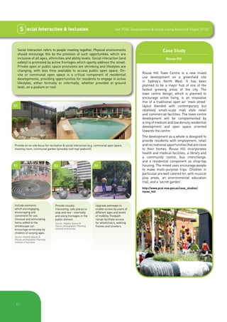
This document provides a checklist for developers to assess how well a development project incorporates principles of active living. It discusses five key principles: walkability and connectivity, active travel alternatives, legibility, quality public domain, and social interaction and inclusion. The checklist includes performance measures under each principle and cases studies of developments that successfully applied these principles. It is intended to help developers design projects that encourage physical activity as part of daily life and create healthy, sustainable communities.
Giovanni Allegretti is an architect and senior researcher at the Centre for Social Studies at the University of Coimbra, Portugal.
Presentation given on Thursday 22nd November 5.30 – 8pm
Wellington Public Library – Mezzanine Floor Meeting Room – lift across from Clarks Cafe
The document discusses the achievements of the Inspire East Design Review and Enabling services over five years. It provides feedback from panel members and users of the services. Key points include:
1) The services reviewed 136 schemes and supported 70 projects, providing independent review and advice to improve quality.
2) Feedback was overwhelmingly positive, with the panel management rated highly. Users found value in gaining different perspectives and resolving issues.
3) The impact on improving schemes was seen in modified masterplans and successful applications, though long-term impact is difficult to measure.
4) Panel members emphasized the importance of community engagement, learning from best practices, and focusing on long-term sustainability and placemaking.
Restart+ Module 5 Financing your Community Regeneration Projectscaniceconsulting
It’s time to talk money. In this module we demystify funding opportunities and help steer you towards some exciting community regeneration funding opportunities.
You will also learn top tips in grant writing and pitching and how to leverage the funding power of many.
As you have become accustomed to, the final section provide you with a pack of useful exercises and templates to help plan and execute funding and financing related actions for your community regeneration projects.
İn the scope of Urban projects at Erciyes University,Faculty of Architecture,Department of City and Regional planning,i benefited remarkably from Charles Montgomery Concept of HAPPY CİTY.
The concept has helped me plan for Alaçam Municipality(A Samsun district,a Black sea region in Turkey) 2019-2040 General land use plan(Urban project 311,1:5000 scale) and its İmplementation plan (411 urban project,1:1000 scale).
This document summarizes a presentation on regional policy and design in open user-driven ecosystems. It discusses how living labs can be used to involve users, test new services, and solve societal challenges. It emphasizes that innovation occurs through collaboration between diverse actors like designers, engineers, businesses, academics, citizens, and policymakers. A systemic approach is needed that considers people and organizations at all levels from individual to global.
The document discusses trends that will shape the futures of museums. It analyzes trends using a framework that examines changes in the external environment, resources, audiences, and talent. Some key trends discussed include squeezed resources, aging populations, the rise of user-generated content, and changing workforce demographics. The document concludes by presenting five potential scenarios for the future of museums based on the trends analysis.
The document summarizes the achievements of PIKOM and WITSA Chairman Dato' Dan E Khoo from 2008 to 2012. Some key achievements include strengthening WITSA's financial position, revising the bylaws, establishing regional offices, increasing membership from 68 to 83 members including adding China, conducting trade missions, and establishing 19 soft landing zones. The document also recaps Khoo's leadership in establishing WITSA's 6-4-2 goals and identifying 8 critical forces to advance WITSA's position as a leading voice of the global ICT industry.
This document outlines the community visioning process for a possible extension of the Green Line to Mystic Valley Parkway. The objectives are to identify community issues, understand impacts of a potential station, and develop land use recommendations. The process involves public meetings to gather input on topics like transportation, land use, and a community vision. It will culminate in a draft report and recommendations to inform MassDOT's decision on extending the Green Line.
Livable St. Louis Conference 2012 Bold Community VisionsTrailnet
This document discusses transforming streets from auto-centric transportation routes to more livable, complete streets that better accommodate all users. It outlines how streets have evolved from multi-use public spaces pre-automobile to prioritizing high-speed auto traffic. The presentation advocates reallocating street space and adjusting speeds to make streets safe, comfortable and convenient for people of all ages and abilities using automobiles, walking, biking and transit.
The WHO Global Network of Age-friendly Cities and Communities (GNFACC) aims to create social and physical environments that foster participation and health across the life course. The Network was launched in 2010 and currently includes 49 cities and hundreds more through affiliated national programs. The goal is to improve quality of life for older populations by connecting cities, exchanging best practices, and promoting age-friendly approaches. Members conduct assessments, develop action plans, and work towards continual improvement over five-year cycles.
Detroit’s downtown is experiencing a renaissance unlike anything it has seen in decades. Largely vacant office buildings are filling up with new businesses and residents, the ground floors will soon welcome new shops and restaurants, and the streets and public spaces throughout the downtown are returning to life. Soon a new streetcar on Woodward Avenue, the M-1, will tie the downtown into the City of Detroit to the north, carrying residents, students and employees into the downtown and linking key destinations.
This report focuses on how the public spaces, and particularly the three major downtown parks, can be transformed, both in the long and short term — beginning summer 2013! — so that they support this exciting commercial and residential rebirth in the downtown, and also become destinations in their own right. To develop these ideas, Project For Public Spaces (PPS) brought into focus the concept of Placemaking to downtown Detroit and engaged the public in the Placemaking process. It is the intention of the stakeholder group to begin implementation of these ideas in order to create safe places for Detroit residents, workers and visitors.
Participatory budgeting (PB) is a democratic process where community members decide how to spend part of a public budget. It is not a one-time event, but involves months of public meetings, discussions, and voting. PB in Vallejo will allocate $3.4 million, or 2% of the city budget, across several phases including brainstorming projects, vetting proposals, public expos, and votes. The goal is to improve and engage the community and transform local democracy.
Css class 8 multi-disciplinary teaming 120309TTI-UTCM
Lesson 8 for Grad Course on CSS (from UTCM Report #08-14-03 "Making Mobility Improvements a Community Asset: Transportation Improvements Using Context-Sensitive Solutions")
The document provides an evaluation of the Pixelate project, which aimed to increase digital media content production across communities in Greater Manchester. It details the project framework, methodology used to evaluate outcomes, and key findings. The project involved over 140 participants from deprived areas across the region in creating 70 digital works. Participants developed new skills and community cohesion was improved. The project leveraged over £200,000 and successfully met its goals of increasing participation and digital skills in underserved communities.
This 3-page document is the 2011-2014 Strategic Plan for the City of Waterloo. It outlines the city's vision, mission, values, and 6 strategic pillars to guide the city over the next 4 years. The first strategic pillar is Sustainability and Our Living Environment. This pillar focuses on acting sustainably to not negatively impact future generations. It identifies objectives such as implementing the city's Official Plan and Environmental Strategy, promoting sustainability within the city, and protecting natural resources. The plan aims to make Waterloo a leader in environmental responsibility.
This document outlines WaterAid India's urban WASH strategy. It was developed through extensive consultation with WaterAid India staff, partners, and external stakeholders. The strategy aims to realize the rights of urban poor populations to access sustainable water and sanitation by 2030. Key issues addressed include sanitation, faecal sludge management, water supply, hygiene, solid waste management, and WASH in schools. The strategic objectives are to provide access to sanitation and safe water for 50% of target communities by 2023, and advocate for the right to WASH to be defined in public policy by 2030. The strategy will be implemented through collaboration, innovative approaches, and engagement with communities, governments, and other partners.
Mapping for Change: Digital Tools and Neighbourhood Design WorkshopNesta
A presentation given by representatives of UCL's Mapping for Change project at our Digital Tools and Neighbourhood Design Workshop, an event designed to explore the impact of digital tools on community design, engagement and improvement.
For more information, visit: http://www.nesta.org.uk/event/digital-tools-and-neighbourhood-planning-workshop
This document introduces a resource to help promote active living through the development assessment process. It outlines five principles of active living - walkability and connectivity, active travel alternatives, legibility, quality public domain, and social interaction and inclusion. The resource aims to assist councils and the state government in developing policies, and to advise consultants, applicants, and assessment officers. It provides advice on matters to consider for different development types, such as residential, industrial, and transport infrastructure projects. The resource draws from an existing website of the Premier's Council for Active Living that provides design guidelines for environments like streets, open spaces, and workplaces.
This document provides an overview of active transportation and its benefits. Active transportation, such as walking and cycling, provides public health benefits by encouraging physical activity. It also has environmental benefits as it generates fewer emissions than motor vehicles. Economically, active transportation infrastructure requires lower development and maintenance costs compared to other transportation. Improving active transportation can also enhance community livability and connectivity.
Creating Places for People: RIAI Town and Village ToolkitRIAI
The RIAI Town and Village Toolkit has been developed by the RIAI and the RIAI Urban Design Committee in response to requests to provide expert advice for people to assess the quality of the towns and villages
where they live, work or have responsibility.
Urban design criteria the holistic approach for design assessmentNik Latogan
The lecture discusses key concepts and principles of urban design. It emphasizes taking a holistic approach that considers various factors such as the people, laws and regulations, activities, time, transportation, physical environment, politics, accessibility, resources, design plans, and space. The lecture also stresses the importance of understanding user needs and involving stakeholders in the design process. It provides guidelines for assessing urban design projects based on established criteria and benchmarks.
This document provides a framework for the City of Shreveport, Louisiana's Comprehensive Energy Efficiency and Conservation Plan (CEECP). The CEECP will build upon initial investments from the Energy Efficiency and Conservation Strategy to develop a long-term strategy for making Shreveport more energy efficient. It will implement a strategic doing process to empower citizens and align resources around innovation to create jobs, save energy, reduce emissions, and improve quality of life. The CEECP will balance environmental, economic, social, and cultural priorities to maximize benefits according to a quadruple bottom line. It will identify and support local assets through an open network model and fast cycles of strategic doing to guide progress and innovation.
Dott07 was a 10-year design promotion program hosted in different regions across the UK every two years. The 2007 program was hosted in North East England and aimed to use design to improve communities and lives, boost the regional economy, and raise awareness of design's value. It included public design projects, education initiatives, and design showcases focused on themes like health, food, energy, education and mobility. The program engaged over 20,000 people and saw some successes, but also had weaknesses in project management, marketing, and regional economic impact.
The document discusses the goals and principles of physical planning. Physical planning aims to design sustainable and livable communities through land use planning, transportation infrastructure, and consideration of environmental and cultural resources. It can take either a rationalistic approach through comprehensive master plans or an incremental approach through smaller individual projects. The goals of physical planning are evaluated using indicators to monitor progress and the social, environmental, and economic impacts of development plans.
This document provides an overview of the City of Port Coquitlam Sustainability Initiative. The initiative was established in 2005 to integrate economic, environmental and social aspects of development through policies and programs. It includes developing a sustainability checklist for development applications, promoting green building standards, protecting water sources, and conducting social planning reviews. The goal is to foster sustainable development that balances economic prosperity, environmental protection and high quality of life for current and future residents.
Irc@zaragoza urban water cooperation without animationsIRC
The United Nations proclaimed 2013 the International Year of Water Cooperation. IRC International Water and Sanitation Centre supports this focus has a wealth of lesson on improving water cooperation through learning alliances. At the UN Water Conference 2013 in Zaragoza, IRC presented lessons on learning alliances for better water cooperation in SWITCH, a multi-country urban water project.
A Step By Step Guide To Monitoring And EvaluationHeather Strinden
This document provides an overview of monitoring and evaluation (M&E) for community groups working on climate change and energy projects. It discusses why M&E is important, including improving projects, demonstrating effectiveness, and contributing to the evidence base. The document outlines key steps for groups to take in planning and implementing M&E, such as deciding what to monitor, involving stakeholders, clarifying objectives, and identifying relevant questions. It also provides examples of M&E methods and links to additional resources.
The document discusses the development of the Whole Journey Guide for accessible public transport by the Australian Department of Infrastructure and Regional Development. The Guide was developed in response to recommendations from the second review of the Disability Standards for Accessible Public Transport. It aims to encourage consideration of accessibility across the entire travel journey rather than just within individual modes of transport. The Guide outlines key influencers on accessibility, different parts of a travel journey, and principles for implementing a whole of journey approach. It emphasizes putting people's needs at the center of transport planning and design.
The document discusses a community engagement event called "Walk & Talk & Nuts & Bolts" that was facilitated by the author in Redmond, Washington to involve the local community in planning for the city's historic downtown core. The author created an "Urban Diary" workbook to guide participants through the historic area and collect feedback on aspects of the built environment through open-ended questions. Twenty-six community members participated in the walking meeting and provided input. The results of the project include the successful community event and a case study report analyzing the collected feedback to inform the city's further engagement efforts.
The document discusses case studies and a survey relevant to service and strategic design in public issues. It provides examples of successful projects that were incorporated into public policies and regional innovation strategies. These include open data initiatives in Helsinki, Finland that improved digital services for citizens. Living lab projects in Barcelona, Spain renewed their cultural industry. The document advocates for a cross-sectoral approach and partnerships between different actors to address challenges like aging populations and promote economic growth.
ACDI/VOCA's Activate is a tool to walk project staff through six steps, resulting in an Social Behaviour Change strategy and M&E plan. First, Activate will provide a set of customizable behaviors with simple guidance on how to select and tailor those behaviors. After projects identify and customize these behaviors, they will have a clearer picture of which behaviors they are trying to change. Activate will then provide training curricula and guidance on barrier analysis and formative research, so that staff will understand how to collect data on drivers and barriers of those behaviors. It will also include a set of sequential decision-making process aides, guidance on best practices from behavioral sciences, and resources on Behavior Mapping to connect target behaviors to M&E processes.
This document provides a report and toolkit to establish a consistent approach for assessing accessibility and inclusion in parks and trails in British Columbia. It outlines principles of universal design and establishes three levels of access - basic, intermediate, and universal. Standards are defined for assessing accessibility of assets, links like paths and trails, and other features. The report also provides a process for parks organizations to establish accessibility teams, conduct assessments, prioritize projects, implement improvements, and monitor progress towards accessibility objectives. The goal is to promote accessible and inclusive recreation for all.
Mammoth Lakes Downtown Revitalization Plan by Darin DinsmoreDarin Dinsmore
This is the public review draft for the Mammoth Lakes Downtown Revitalization plan that includes a first of its kind Incremental Development program, and "preapproved" mixed-use main street buildings". The Action Plan is designed to kickstart downtown revitalization and more housing choices. The actions were developed from an extensive online and in-person public process and dozens of meetings with property owners and stakeholders. The benchmark tool @infillscore.com was used to help create a baseline to compare to other resort community downtowns.
Thank you for the presentation. Developing a comprehensive project plan takes significant effort and collaboration. I wish you all the best moving forward with implementing your recommendations.
Small Enterprises and CSR Strategy Building and implementing a sustainable CS...UN Migration Agency (IOM)
This document discusses how small enterprises can implement corporate social responsibility strategies with limited budgets. It provides examples of how small hotels in Thailand were able to incorporate CSR practices that improved profits and benefited communities. Through workshops on sustainability and the Envirotel program, over 200 small hotels implemented projects to reduce costs, waste, and pollution. Examples included installing efficient lighting, reducing laundry and water use. The initiatives engaged employees and customers, saving hotels over $500,000 annually while creating jobs and supporting local causes. The key is aligning CSR with business goals, pursuing cost savings, engaging stakeholders, and utilizing training opportunities.
The document discusses private sector development in Australia's aid program. It notes that private capital flows, remittances, and trade contribute far more to developing economies than official development assistance. Australia's aid program aims to promote private sector growth in developing countries by engaging businesses in the design and delivery of aid investments, innovative financing approaches, public-private partnerships, and improving regulations. The program also supports global economic growth and facilitates trade, investment, and partnerships between Australian and developing country businesses.
This document summarizes a presentation by Susan Roxas of WWF Greater Mekong on business and NGO collaboration. It discusses why companies work with NGOs such as for expertise and credibility, and why NGOs work with businesses to leverage their resources and influence industries. Some risks of collaboration include greenwashing and lack of transparency. Areas of potential collaboration include climate and energy, sustainable production, water stewardship, and joint communications. Examples of partnerships include work with financial institutions on sustainability and a project with IKEA to sustainably source rattan in Southeast Asia.
The document provides an overview of corporate social responsibility (CSR) in Lao PDR. It finds that while CSR is still a relatively new concept, certain sectors like coffee, tea, and hydropower are beginning to adopt CSR initiatives in response to consumer and investor demands. It also identifies opportunities to further promote CSR activities and compliance with social and environmental standards and regulations in the country. These include developing sector-specific CSR guidelines, establishing a CSR stakeholder committee, and integrating CSR into existing development programs.
The document discusses corporate social responsibility (CSR) in ASEAN countries. It outlines the ASEAN Community Blueprint's recognition of CSR and objectives to promote CSR. Key actions recommended include developing CSR policies and standards. The document also discusses trends in CSR across ASEAN countries like increasing engagement from governments and stock exchanges. Challenges include the majority of businesses being SMEs and sensitivities addressing issues like human rights. Country-specific CSR examples from Philippines, Indonesia, Myanmar and Thailand are provided. The document concludes with recommendations for further developing CSR in Lao and the ASEAN CSR Network's commitments.
The document discusses corporate social responsibility (CSR) in Laos and increasing quality investments that reduce poverty and minimize environmental impact. It recommends delivering quality investments through thorough environmental impact assessments, ongoing investor reporting, inter-ministerial monitoring, and enforcement. Finally, it addresses the current status of CSR in Laos and how to encourage its adoption in a culturally appropriate way.
This document discusses the importance of social license to operate for businesses. It defines social license as a local community's acceptance of a company's presence and activities. While not a formal license, it is important for development and protecting investments by building trust and partnerships with communities. The document outlines principles and tools for obtaining and maintaining social license through early and ongoing engagement, transparency, and community benefit. It also discusses challenges in applying global guidance at the local level and ensuring social license remains relevant to local contexts.
This document discusses community investment strategies for businesses. It defines community investment as a company's long-term strategic involvement in community partnerships to address social issues in a way that benefits both the community and the company. Effective community investment requires developing initiatives to meet community needs through providing resources like equipment, human skills and business networks. It should be a sustained effort done in partnership with communities to create long-term social and business value, rather than just short-term donations. The document provides examples of how businesses can identify local needs and partner with organizations to structure community investment programs that benefit both communities and company operations and goals.
Mai Savanh Lao is a Fair Trade company in Laos established in 2005 to help mulberry farmers and silk weavers. It produces high quality Lao silk and tea products. The company employs 40 full-time staff and works with 150 silk farmers and 40 weavers. It adopts Fair Trade values like paying fair prices, ensuring good working conditions, and investing profits back into the community and business. Adhering to Fair Trade principles has helped the company access international markets while creating opportunities for disadvantaged producers and positive social impact.
The EXO Foundation was created by EXO Travel to support sustainable development projects in tourism destinations through community donations. It funds a variety of projects focused on education, health, the environment, and economic development. Projects include supporting cultural centers in Laos, ecotourism experiences owned by local villages, and Travelife certification for sustainable practices. The foundation relies on donations from EXO Travel clients and aims to integrate ethical practices within the company and give back to communities impacted by tourism.
This document outlines the environmental and social obligations of investment companies in Laos, including complying with relevant legislation, conducting environmental and social impact assessments, and ensuring public involvement. It discusses the process for screening projects, conducting Initial Environmental Examinations and Environmental and Social Impact Assessments, and obtaining Environmental Compliance Certificates from the Ministry of Natural Resources and Environment. It emphasizes the importance of avoiding, minimizing and mitigating impacts, as well as obtaining free prior and informed consent from affected communities and establishing grievance mechanisms.
This document summarizes corporate social responsibility initiatives at the Sepon mine in Laos. It discusses four key initiatives: 1) Partnership for Development which is working with local farmers on high-value crops like mandarin and silk; 2) Developing Small Business which has created over 400 jobs and $3 million in income through business training; 3) Improving Rice Yield and Milling which is working with over 1,300 farmers and 8 millers to increase rice yields and income; and 4) Infrastructure Development which includes building roads, electricity, and donating over $3 million to community projects. The initiatives aim to create jobs, increase incomes, and support long-term sustainable development in the local communities.
The document discusses corporate social responsibility (CSR) and how the private sector can contribute to achieving national development goals in Lao PDR. It notes that the implementation of the country's 7th National Development Plan requires 50% funding from taxes derived from foreign direct investment. The plan could benefit from a closer working relationship with the private sector. It identifies key targets where the private sector can help, such as reducing poverty and increasing access to water and sanitation. The document recommends that the private sector work with the government to achieve targets through community development initiatives while the government promotes business and shows support for CSR efforts.
This document summarizes research into addressing social isolation in residential apartment buildings through communal spaces and facilities. It outlines that urban consolidation is increasing apartment living, but this risks social isolation which impacts well-being. Neighbouring and a sense of community can counter isolation. The research examined case study buildings to identify features that encourage social interaction. It found that small communal spaces located near entries/exits with casual seating can foster chance meetings and relationships between residents more than large formal facilities. The report recommends guidelines for SEPP 65 to incorporate such spaces into apartment design to promote community and reduce isolation.
This document provides an independent audit of Victorian public library buildings commissioned by the State Library of Victoria. It finds that many library buildings are aging and may not be well equipped to meet future community needs. The audit assessed building condition, functionality, and compliance with accessibility standards through a survey of local government authorities. It recommends strategies to help ensure library buildings are fit for purpose, including establishing space and quality benchmarks, providing capacity building support, and encouraging the development of library-community hubs.
2. Why Active Living?
The PCAL Development
& Active Living Resource
Active living refers to opportunities for incorporating physical
activity into the routines of daily life, as well as for sport and This Checklist is a companion document
recreation. Examples of Active Living include walking or to the Premier’s Council for Active Living
cycling with children to school; walking, cycling or catching (PCAL) publication “Development & Active
public transport to work; or replacing short car trips to corner
shops and parks by walking or cycling. Living: Designing Projects For Active Living
– A Development Assessment Resource &
Across all aspects of their lives, most people are less
Navigational Tool.” The PCAL Development
physically active than they need to be. As well as the burden
this places on the health of individuals, a growing body of & Active Living Resource brings together
evidence also demonstrates the social costs are significant – existing material already available from a wide
active communities are more likely to be strong and connected range of sources and aims to assist councils
communities showing greater participation in activities. 1 (and the State Government) address Active
Evidence clearly demonstrates that the built environment of Living within their plans and policies (such
our cities and local neighbourhoods can either facilitate or as Development Control Plans) and provide
discourage Active Living.2 Studies show that communities specific advice on matters for consideration
designed with Active Living-friendly design considerations
in mind (e.g. good access to destinations (including public
in development assessment that will promote
transport), connected street networks, higher residential Active Living.
densities, and access to quality open space) benefit from
The PCAL Development & Active Living
reduced car trips, increased walking trips 3 and reduced overall
housing costs.4 Active people make their neighbourhoods Resource is also a useful reference for the
safer and more liveable. Walking, cycling and public transport private sector, providing a wealth of more
provide opportunities for social connection and inclusion. detailed information about the concepts and
So designing urban spaces that help us incorporate physical principles of Active Living. The Development
activity into our everyday lives not only helps us, it also helps & Active Living Resource also provides a
our environment and our communities. Increasingly, it is a more detailed guide to specific Active Living
point of differentiation being sought by new home buyers. issues which arise within a wide range of
Active communities are more sustainable, liveable and
desirable places to be. land use types.
Much of what is required is relatively straightforward, The PCAL Development & Active Living
being easy to incorporate within most developments. Not Resource can be found at:
just cost-neutral, designing for Active Living can add value
http://bit.ly/PCAL-DA
to development when done up-front through the planning
process.
The advice in this Checklist will assist you to make your
development an active one.
For more information see PCAL’s “Why Active Living”
Statement (http://bit.ly/PCAL-WhyAL).
Home Buyers Prefer Liveable Communities
Opinion polls and recent government community The following Active Living features were rated as
consultations have shown consistently that people place important or very important -
great importance on their health, their independence, their • being within walking distance to public transport (69%);
happiness and a feeling of wellbeing. People want a sense • being within easy walking distance to local services such
of community and social connectedness. They want more as shops or cafés (64%);
freedom to move, and places to move in. They want cleaner • having a paved or concreted footpath in every street
air, greener streets and a greater sense of well-being. (51%); and
In October 2009, the Heart Foundation (NSW) commissioned • being within easy walking distance to a local park (46%),
a telephone survey of 1403 randomly selected adults in And were all deemed to be higher priorities than:
Sydney, Melbourne, Brisbane, Adelaide and Perth seeking • having a two-car garage (44%); and
to identify what is important to people in deciding where • having a large backyard (39%).
to live.
Research from overseas and Australia has concluded that
the provision of open space and access to transport can
attract higher housing prices.5,6
|1
3. Purpose of the Checklist
This tool has been developed by PCAL to advise on urban design
factors that will promote active living in your development.
As a best practice resource for developers to self assess
their developments, the checklist will be a useful starting
point for discussions with Consent Authorities about how
Active Living has been incorporated in the formulation of your
development proposal. It will also help to demonstrate how
your development has responded to the NSW Department
of Planning Position Statement: Planning for Active Living
(http://bit.ly/PCAL-DoP).
This Checklist is not a set of prescriptive requirements,
rather it aims to provide a voluntary menu of ideas which
can be realistically incorporated by developers into their
developments for maximum effect. Not all measures will be
able to be achieved in every instance, as this will depend on
the nature of the development, the site, and its local context.
Responses will vary for example between greenfield and urban
renewal sites. Some measures may only apply to large-scale
projects. An innovative, rather than prescriptive approach is
required.
How to Use this Checklist
The Developer’s Checklist has summarised key design
outcomes according to five Active Living Principles outlined
within the PCAL Development and Active Living Resource. The
principles are:
W alkability & Connectivity
A ctive Travel Alternatives
L egibility
Q uality Public Domain
S ocial Interaction & Inclusion
The Checklist describes key Outcomes Sought from
developments within each Active Living Principle and provides
a number of Performance Measures to help demonstrate their
application.
User Hierarchy
While this advice is ordered by Active Living Principle, it is
important that the movement framework for a development
Consider First • Pedestrians
proposal, prioritising pedestrians, cyclists and public transport,
is established early in the design process. This is represented • Cyclists
in Figure 1, which indicates how the hierarchy of users should • Public transport
be prioritised throughout the design.
• Specialist service vehicles,
As you work through the Checklist, tick the boxes which you car share, and taxis
consider your development achieves. Where a measure cannot Consider Last • Private motor vehicles
be achieved, space is provided for justification and comment.
Source: Department for Transport (UK), 2007,
"Manual For Streets", Thomas Telford Publishing
Figure 1. User Hierarchy
2|
4. WALQS are the key Principles that are relevant to development:
W alkability & Connectivity See PCAL Development & Active Living Resource Pages 11-14
Walkability is how friendly a place is to pedestrians, whether it invites Case Study
and encourages people to walk. Considering the comfort of walkers
during the design and approval process will greatly impact upon the Newleaf Bonnyrigg Public
walkability of an area. Carefully designed and equipped spaces along Housing Re-development
routes to key local destinations, will make walking and cycling attractive,
encouraging the community to be active.
The Bonnyrigg Living Communities Project
(also known as Newleaf) is a NSW
Government initiative to redevelop and
W5 revitalise a large 1970s public housing
W2 W3
estate in Western Sydney. The site
is located within the Fairfield Local
Government Area.
The redevelopment will transform the
existing three to four bedroom townhouses
and cottages into a more diverse mix of
housing types. The number of dwellings
on the site will increase from 933 to 2,332.
The new housing mix will be 70% private
Retrofit pedestrian Attractive streetscapes Street design which and 30% community housing.
connections to the support walking and controls traffic
network which restore stimulate a vibrant retail speeds, particularly A key aim of the redevelopment is to
route directness (e.g. environment. Landscape at intersections (for
enhance connectivity with the surrounding
through-site links). for shade, comfort and example, narrowing
Ensure that newly visual interest. the roadway, not using urban area, enabling people to walk or
proposed streets and Source: Healthy Spaces & roundabouts). Shared cycle to nearby services, facilities, and
paths align and link to the Places, photographer SGS spaces (“naked streets”) public transport. Walking and cycling
Economics and Planning are an effective and
surrounding network. shareways and pedestrian paths are
affordable way to slow
provided in the Concept Plan, focusing
traffic. Well designed
intersections are also on key routes both within the estate
an important part of the and to surrounding facilities, including
pedestrian environment schools, shops, bus stops, transitway
and the walking station, pedestrian crossings and places
experience.
of worship. The proposed road, pedestrian
LOW DENSITY RESIDENTIAL LOTS WITHIN 5 MINUTE WALK and shared pedestrian/cycle networks
W7 RETAIL
W7 WALKABLE ROUTE 400M (5 MINUTES)
CIVIC SPACE W9 provide for the separation of movements
and safe places for pedestrian and cycle
crossings at traffic intersections. Key
routes are well lit to facilitate safe night-
time movement.
http://www.pcal.nsw.gov.au/case_studies/
bonnyrigg_living_communities_project
A lack of connections A connected street Provide for the comfort
discourage walking and network brings the of walkers (e.g. weather
cycling reinforcing car majority of places within protection, places to
use. a walkable catchment of stop and rest, pedestrian
Source: Healthy Spaces & 400 metres. Permeable crossings). Shelter can
Places, TPG Town Planning & urban blocks with be provided by trees or
Urban Design multiple routes for built form. Seating can
walking and cycling are be of both a formal and
available. informal nature (such
Source: Healthy Spaces & as the integration with
Places, TPG Town Planning & planter boxes and other
Urban Design landscape features).
|3
5. Walkability And Connectivity Checklist
Performance Measure Yes n/a Justification & Comments
Outcome Sought: Walking is Convenient, Safe and Attractive
W1 Footpaths are provided at all street frontages (both sides
where possible).
.................................................................
W2 Movement past and through the site is facilitated (including
possible through-site connections).
.................................................................
W3 Public facilities are provided for the comfort of walkers (i.e.
shade, shelter, seating).
.................................................................
W4 Appropriately located pedestrian entrances (i.e. direct and
convenient access from streets and adjacent uses; separated
.................................................................
from traffic; prominent and well-lit, with passive surveillance). .................................................................
W5
Speed of vehicles is controlled through the design of the
development (for example, narrower road widths,
.................................................................
intersections, shorter straight lengths, pedestrian friendly .................................................................
car park entries), rather than by relying on retrofitting traffic
calming devices. .................................................................
Outcome Sought: Streets and Pathways Integrate with the Adjoining Urban Structure to Improve Connectivity and
Reduce Local Travel Distances
W6 Streets and pathways connect logically to existing vehicle, .................................................................
pedestrian and cycle networks and do not simply stop at the
site boundary.
.................................................................
W7 A choice of routes are provided, leading to local destinations
.................................................................
and focal points (such as shops, schools, parks and public
transport stops).
.................................................................
W8 Routes are unobstructed, continuous and direct.
.................................................................
W9 Safe and easy access across streets is provided (e.g.
pedestrian crossings and other aids, close to the direct line
.................................................................
of travel). .................................................................
4|
6. A ctive Travel Alternatives See PCAL Development & Active Living Resource Pages 15-20
Active Travel Alternatives are modes of transport that involve physical
activity, such as walking, cycling, public transport and car sharing/
Case Study
pooling. Efforts should be made to reduce car reliance and promote such
Optus Relocation
alternatives. The availability and accessibility of ‘end-of-trip’ facilities
(such as cycle parking and showers) can influence and encourage the
decision to walk or cycle to work, which can positively impact upon
health and well-being. How do you get over 6,500 people
to work at a new site in a suburban
business park with 2,002 employee
car parking spaces?
A1 A3 A8
Driven by the relocation of Optus employees
from nine sites across Sydney to one newly
built campus in Macquarie Park, the Optus
Sustainable Transport Strategy was designed
to increase employees commuting travel
choices, with an emphasis on improving
access by sustainable modes of transport.
Key initiatives include:
Provide appropriate End-of-trip facilities The location of • additional on-site infrastructure.
walking and cycling facilitate walking and convenience shopping
infrastructure. cycling. facilities, workplaces, • pedestrian audits of local streets.
Source: Brisbane City Council and community facilities
and Queensland Transport , • staff engagement and consultation.
in close proximity to
City2City (C2C) Initiative.
residences reduces • communication and information
car trips and promotes
dissemination via traditional (e.g.
walking.
Source: NSW Government (2004),
newsletters, pocket guides) and
Planning Guidelines for Walking non-traditional channels (e.g. SMS
and Cycling.
mobile alerts, online journey planners
and travel ‘clinics’).
• Partnering with public transport providers
A9 A11 A12 to tailor services.
• Car Parking Policies which manage
demand for parking spaces (e.g. parking
fees, ride share scheme).
• Reducing the need to travel, by locating a
childcare centre, gym and a convenience
store on site. Best practice remote and
flexible working policies are a cornerstone
of reducing the need to travel.
Residential densities Travel Plans promote Car pooling options
the use of sustainable should be incorporated As a result, approximately 40% of Optus
near public transport
corridors and service transport options and within parking areas. employees commute by public transport,
nodes should be can be prepared for walking or cycling compared to 10% of all
maximised appropriately. most development types, other employees in the local area.
The integration of mixed commonly workplaces, but
land uses such as also schools, residential http://www.pcal.nsw.gov.au/case_studies/optus
residential, open space developments, stations,
and neighbourhood stadia and hospitals. They
commercial outlets into involve the preparation of
a compact subdivision a Transport Access Guide.
allows people to walk and (Image courtesy of Optus).
cycle shorter distances
and undertake multiple
activities within the one trip.
Source: NSW Government (2004),
Planning Guidelines for Walking
and Cycling.
(Image courtesy of Optus).
|5
7. Active Travel Alternatives Checklist
Performance Measure Yes n/a Justification & Comments
Outcome Sought: Walking and Cycling is Supported and Promoted
A1 Appropriate walking and cycling infrastructure is provided. .................................................................
This includes:
.................................................................
• Walking and cycling pathways provided to all building
entrances. .................................................................
• Shared paths are carefully designed, with sufficient
width, adequate sightlines, gentle gradients and turns, .................................................................
and marked centrelines.
.................................................................
• Space provided on streets for cyclists, with appropriate
signage and road markings where dedicated cycle lanes .................................................................
aren’t provided.
A2 Design reduces conflict with traffic. This includes: .................................................................
• Treatment of building entrances.
.................................................................
• Roundabouts are minimised as an intersection treatment.
• Dedicated cycle lanes provided on high volume roads. .................................................................
A3
Provision of conveniently located, safe bicycle parking
areas which satisfies the rate of provision specified in
.................................................................
NSW Guidelines.7 .................................................................
A4
Provision of amenities (e.g. changing rooms and showers) for
men and women.
.................................................................
Outcome Sought: Public Transport is Available and Accessible
A5 Pathways directly link to the nearest public
transport stops. Ideally public transport stops should
.................................................................
be located within walking distance (i.e. 400 metres along .................................................................
a connected pathway) of all dwellings, workplaces,
and businesses.
A6
Where the development proposes new streets, major
streets are designed to accommodate bus access.
.................................................................
A7
Where the development is located adjacent to a bus
route, bus stops are provided or upgraded along the
.................................................................
street frontage (i.e. shelter and seating). .................................................................
Outcome Sought: Reduce the Need to Travel by Car
A8 Trip generating land uses which meet local need are .................................................................
incorporated in the development (e.g. convenience shopping
facilities, workplaces, and community facilities). .................................................................
A9
Residential densities near public transport corridors and
service nodes are maximised appropriately.
.................................................................
A10 Prioritisation of pedestrians and cyclists over vehicular
access routes.
.................................................................
A11 TMAP / Travel Plan / Transport Access Guide prepared to .................................................................
encourage the use of alternative forms of transport.
A12 Priority parking provided for car pooling and car sharing. .................................................................
A13 Car parking levels provided are appropriate to the
location and nature of the development and its accessibility to
.................................................................
public transport. .................................................................
6|
8. L egibility See PCAL Development & Active Living Resource Pages 21-22
Legibility is a measure of how well the surrounding environment
promotes an awareness of relative location, allowing people to orientate Case Study
themselves in their physical environment and navigate from one place
to another. Places which are perceived as being safe, welcoming and Chippendale, Sydney
enjoyable through effective wayfinding systems are likely to be used
more frequently. For example, knowledge of the local environment can
provide the confidence to walk or cycle. The inner city suburb of Chippendale is
an example of a street environment that
encourages walking and cycling. Careful
planning and management of the public
L3 L3 L4 domain, particularly with regard to traffic
calming measures, has created a highly
pedestrianised and community-friendly
neighbourhood island amidst busy arterial
roads and major land uses.
Preservation of the grid street layout
and laneways provides a connected and
legible street network that maximises
convenience for pedestrians. Road closures
and footpath extensions are used to create
Wayfinding elements A clearly defined route Directional signage more public open space, deter through
can be delivered through marked by design provided within larger
developments. (eg. Maps
and fast travelling traffic, and establish
architectural design as features.
well as visual, audible and of larger developments) car-free short-cuts for pedestrians and
Source: Healthy Spaces & Places,
tactile communication photographer TPG Town Planning cyclists. Trees and planting, including
elements. (eg. a street & Urban Design. garden beds maintained by residents,
map represented in the provide a sense of ownership and a
footpath) pleasant environment for walking around.
Footpaths have been widened at a number
of street corners, creating space for trees
L5 L5 and other planting, including garden
beds tended by residents. Attention to
footpath detailing gives an impression that
pedestrians matter and enhances local
heritage, community amenity and sense
of place.
http://www.pcal.nsw.gov.au/case_studies/
chippendale
Localities, pathways and Royal North Shore Hospital – Before and after the
junctions should be well implementation of a signage strategy.
signposted. Source: NSW Health, (2009), Technical 2 Series “Wayfinding for Health
Facilities”, published 25 June 2009.
|7
9. Legibility Checklist
Performance Measure Yes n/a Justification & Comments
Outcome Sought: Streetscape and Pedestrian Environment are Recognisable and Coherent
L1 Design encourages user familiarity (e.g. the development’s .................................................................
design statement defines a coherent local identity and
character; consistent themes are embraced). .................................................................
L2
Legible street and pathway layout proposed (i.e. streets
are of a modified grid layout, with a regular, permeable
.................................................................
block structure and smaller block sizes). .................................................................
L3
Orientation features (such as landmarks and key sites)
incorporated into public domain planning (e.g. streets and
.................................................................
pathways). .................................................................
Outcome Sought: Residents, Employees and Visitors are Informed
L4
Localities, pathways and junctions are well signposted.
Directional signage provided to key points, such as bus stops
.................................................................
and cycle routes. .................................................................
L5
Way Finding Strategy proposed for larger scale
development. Wayfinding incorporates the processes of
.................................................................
knowing where you are, where you are going to, the best .................................................................
way to get there, recognising when you have arrived at your
destination and knowing how to leave the area. .................................................................
8|
10. Q uality Public Domain See PCAL Development & Active Living Resource Pages 23-28
Most physical activity takes place in the public domain, on streets and in Case Study
parks. Places which are welcoming, activated and stimulating are more
likely to be used. Successful places are safe, comfortable and engaging, Nelson’s Ridge
providing a setting for socialisation as well as physical activity. They
are adequately serviced by appropriate infrastructure, adaptable to a
variety of uses, are activated by activity generating uses, accessible to all,
connected to local destinations, and engage multiple senses of their users. Nelson’s Ridge is a masterplanned mixed
use development of 1,575 homes in Western
Sydney. The development is notable for the
large amount and variety of high quality
public open space that is provided, with 40%
Q1 Q5 Q9 of the site dedicated to open space. Over
five kilometres of walking and cycling trails
link homes to a wide range of passive
and active recreation facilities, including
regional infrastructure beyond the site.
It also incorporates many recreational
facilities that provide opportunities for
social interaction and activity, such as a
barbecue or picnic. These facilities are
located adjacent to children’s playgrounds,
Attractive and welcoming Landscaping plays Provide generous,
purposeful and well-
providing community gathering spaces for
building frontages, a significant role in
which address the creating an attractive and defined public spaces. people of different ages.
street. Building form welcoming place with a Quality is more important With a more grid-like street pattern,
which contributes to distinct identity (via street than simple size however.
the character of the trees, landscape elements
oriented towards key activities, the street
Source: Landcom Open Space
streetscape. and street furniture). Design Guidelines, page 33. and path network of Nelsons Ridge
Source: Healthy Spaces & has been designed to ensure permeability
Places, photographer TPG Town and walkability. Pedestrian footpaths are
Planning & Urban Design.
provided on each side of all residential
streets.
Q6 Q10 http://www.pcal.nsw.gov.au/case_studies/
nelsons_ridge
BUILDING TO DEFINE
EDGE OF SPACE
BESIDE ROAD CAFE FEATURE SEATING SHADE
People are more likely to use an area, including as a route Provision of well-designed
to a destination or for active recreation and leisure, if they and maintained facilities
feel safe. Safety is encouraged through adherence to crime to encourage both active
prevention (CPTED) principles, such as an effective land and passive use of public
use mix which promotes casual surveillance. Active use of open space.
boundaries encourages people to frequent an area.
Source: Healthy Spaces & Places, TPG Town Planning & Urban Design.
|9
11. Quality Public Domain Checklist
Performance Measure Yes n/a Justification & Comments
Outcome Sought: Places which are Welcoming, Activated and Stimulating
Q1 Attractive and welcoming building frontages proposed, which .................................................................
address the street.
Q2 Building form contributes to the character of the streetscape. .................................................................
Q3 Active frontages incorporated where possible. Non-
residential land uses are co-located in focal points at places
.................................................................
of high accessibility. .................................................................
Q4 Preparation of/ contribution to a Public Domain Plan. .................................................................
Q5 Landscape design creates an attractive and distinct identity
(via street trees, landscape elements and street furniture).
.................................................................
.................................................................
Outcome Sought: Places which are Safe
Q6
Adherence to Crime Prevention Through Environmental
Design (CPTED) principles, demonstrated by Crime Risk
.................................................................
Assessment (i.e. surveillance, territorial reinforcement, .................................................................
access control and space management).
Q7 Design minimises conflict between pedestrians, cyclists
and vehicles. For example, cyclists and pedestrians are
.................................................................
separated on major routes. .................................................................
Q8 Public domain is well-lit.
.................................................................
Outcome Sought: Access to Usable Open Space, with Facilities for different Ages, Abilities and Ethnicities
Q9 Adequate levels of usable open / communal space located in
prominent and accessible locations.
.................................................................
Q10
The size, layout and facilities within open / communal
space provide for socialisation and activity and are capable
.................................................................
of accommodating a variety of uses which reflect the likely .................................................................
demography and social needs of residents.
.................................................................
10|
12. S ocial Interaction & Inclusion See PCAL Development & Active Living Resource Pages 29-32
Social Interaction refers to people meeting together. Physical environments Case Study
should encourage this by the provision of such opportunities, which are
inclusive of all ages, ethnicities and ability levels. Social interaction (and Rouse Hill
safety) is promoted by active frontages which openly address the street.
Private open or public space provisions are shrinking and lifestyles are
changing, with less time available to access public open space. On-
Rouse Hill Town Centre is a new mixed
site or communal open space is a critical component of residential
use development on a greenfield site
developments, providing opportunities for residents to engage in active
in Sydney’s North West. It has been
lifestyles, either formally or informally, whether provided at ground
planned to be a major hub of one of the
level, on a podium or roof.
fastest growing areas of the city. The
town centre design, which is planned to
encourage active living, is an innovative
mix of a traditional open air ‘main street’
S1 layout blended with contemporary but
relatively small-scale mall style retail
and commercial facilities. The town centre
development will be complemented by
a ring of medium and low density residential
development and open space oriented
towards the centre.
The development as a whole is designed to
provide residents with employment, retail
Provide an on-site focus for recreation & social interaction (e.g. communal open space, and recreational opportunities that are close
meeting room, communal garden (possibly roof-top/ podium)). to their homes. Rouse Hill incorporates
health and medical facilities, a library and
a community centre, bus interchange,
and a residential component as shop-top
S1 S3 S6 housing. The mixed uses encourage people
to make multi-purpose trips. Children in
particular are well catered for, with musical
play areas, an environmental education
trail, and a ‘secret garden’.
http://www.pcal.nsw.gov.au/case_studies/
rouse_hill
Include elements Provide visually Upgrade pathways to
which are engaging, interesting, safe places to enable access by users of
encouraging and stop and rest - internally different ages and levels
convenient for use. and along frontages in the of mobility. Footpath
Unusual and stimulating public domain. ramps facilitate access
items added to the Source: Healthy Spaces & for wheelchairs, walking
streetscape can Places, photographer Planning frames and scooters.
encourage active play by Institute of Australia.
children of varying ages.
Source: Healthy Spaces &
Places, photographer Planning
Institute of Australia.
|11
13. Social Interaction & Inclusion Checklist
Performance Measure Yes n/a Justification & Comments
Outcome Sought: Opportunities to Interact
S1 Provision of an on-site focus for social interaction (e.g. .................................................................
communal open space, meeting room, communal garden
(possibly roof-top/ podium)). .................................................................
S2
For larger scale development, access provided to facilities
which satisfy residents’ social, cultural, recreation and health
.................................................................
needs (on-site where possible). .................................................................
S3 Provision of visually interesting, safe places to stop and rest .................................................................
- internally and along frontages in the public domain.
S4 Provision of a new residents’ “Welcome Pack”.
.................................................................
S5
Promotes a street focus (e.g. active land uses, building
addresses the street).
.................................................................
Outcome Sought: Barrier Free Movement and Entry
S6
Compliance with Disability Discrimination Act (DDA)
requirements and local accessibility standards, demonstrated
.................................................................
by an Accessibility Assessment. .................................................................
12|
16. NSW PREMIER'S COUNCIL FOR ACTIVE LIVING
MEMBER AGENCIES
Communities NSW - Commission for Children and Young People
Communities NSW - Sport and Recreation
Department of Education and Training
Department of Environment, Climate Change and Water
NSW Health
Department of Human Services - Ageing, Disability and Home Care
Department of Human Services - Housing NSW
Department of Planning
Department of Premier and Cabinet
Department of Premier & Cabinet - Division of Local Government
Transport NSW
Roads and Traffic Authority
I|