The document summarizes the geology of the Isle of Raasay in Scotland. It describes the island's basement rocks as Lewisian gneiss formed over 3 billion years ago. Sediments from eroded mountain ranges were deposited as Torridonian Sandstone over 1 billion years ago. Younger Mesozoic sediments including Triassic, Jurassic and Cretaceous periods were deposited in various shallow marine to terrestrial environments. During the Cenozoic era, the region experienced volcanism and intrusions of basalt and granite. Glaciation during the Pleistocene sculpted the modern landscape and deposited till.
Coautor. Presenta análisis químicos del plutón Huemul que indican segregación de riolita al interior del plutón. Para artículo completo, favor contactarme.
TURBIDITES: MODE OF FORMATION OF TURBIDITES AND ITS ECONOMIC IMPORTANCEJames Opemipo OLOMO
Turbidites are deposits resulting from turbidity currents. They are gravity driven sediments derived mostly from the continents and are deposited on the ocean floor when the transporting medium loses its energy. These turbidite deposits are sealed most times by shales to form a stratigraphic trap. If the factors required for hydrocarbon accumulation in a petroleum play system are prevalent, then the turbidite will most likely serve as a good reservoir to house hydrocarbon. Our modern day economy requires enormous amount of energy to meet the energy demand and hydrocarbon unarguably is a non-renewable resource. Perhaps its worth mentioning that the decrease in reserves. And it has been established that turbiditic deposits help to host important economic resources such as hydrocarbon, when the right conditions are emplaced. Hence, the need to understand their formation for exploration success.
Post -script: This presentation is a short review of the topic
The earliest (Precambrian) history of the earth's crustDhanBahadurkhatri
The duration of the Precambrian era and the earliest known state of the crust, Development of Archean Cratons, the Precambrian shield rocks, Paleogeography during Precambrian, and Precambrian glaciations.
Hunting geo famous Martian landmarks using WorldWide Telescope (WWT).
Watch the virtual tour in the WWT/Mars application.
Find the next interest points using the search option:
- Cydonia -"Face on Mars“; "Olympus Mons" – the biggest volcano from our solar system; “Valles Marineris” – the biggest canyon from planet Mars; “Gusev Crater”.
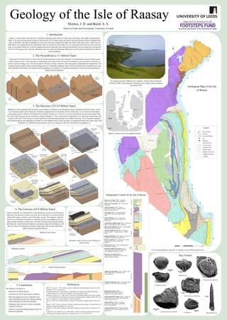
A dissertation project in partial completion of Durham Universities Geology F600 Program with funding from Durham Universities Department of Earth Sciences. Fieldwork was carried out over a period of 6 weeks from the Oystercatcher House B&B, Raasay.
Geological synthesis excercise in stonehaven using fieldmove app TomAdamson7
The poster was produced using the most recent Fieldmove Clinometer software and Google Earth. Stereonets were produced using Stereonet 10 Software, and Adobe Illustrator was used to create and edit the map and interpretations.
Hunting geo famous Martian landmarks using WorldWide Telescope (WWT).
Watch the virtual tour in the WWT/Mars application.
Find the next interest points using the search option:
- Cydonia -"Face on Mars“; "Olympus Mons" – the biggest volcano from our solar system; “Valles Marineris” – the biggest canyon from planet Mars; “Gusev Crater”.
A dissertation project in partial completion of Durham Universities Geology F600 Program with funding from Durham Universities Department of Earth Sciences. Fieldwork was carried out over a period of 6 weeks from the Oystercatcher House B&B, Raasay.
Geological synthesis excercise in stonehaven using fieldmove app TomAdamson7
The poster was produced using the most recent Fieldmove Clinometer software and Google Earth. Stereonets were produced using Stereonet 10 Software, and Adobe Illustrator was used to create and edit the map and interpretations.
Hawaii's Most Active Volcano: Here's The Latest On Kilauea's Eruption
The Kilauea volcano is located in the southeastern part of the Big Island of Hawaii.
Believe it or not, Kilauea has been erupting continuously since 1983, with only occasional pauses of quiet activity. This particular "episode" of the eruption began in the late afternoon of May 3, in a part of Leilani Estates, a subdivision near the town of Pahoa.
Officials said there is no way to predict how long the eruption will continue or what shape it will take. This eruption could be finished or could go on for a long time.
Kilauea is one of the most active and well-monitored volcanoes in the world. It's been erupting on and off for hundreds of thousands of years.
All of Hawaii is a tourist destination, but this particular eruption wasn't in an area where most tourists go. The homes at risk are in a subdivision near the town of Pahoa.
Source: USA TODAY. By Doyle Rice. May 4, 2018, accessed May 5, 2018
<https://www.usatoday.com/story/news/nation/2018/05/04/hawaii-volcano-eruption-kilauea-big-island/580466002/>
________________________
Kilauea Volcano Erupts, Spewing Lava and Gases Near Homes in Hawaii
Governor David Ige has issued an emergency proclamation and has called up the National Guard to help emergency workers with evacuation efforts.
Source: THE NEW YORK TIMES. By Meghan Miner Murray, Sabrina Tavernise and Maya Salam. May 4, 2018, accessed May 5, 2018
<https://www.nytimes.com/2018/05/04/us/kilauea-volcano-eruption-hawaii.html>
A great landmass which was thought to be in the geological past, splitting into fragments drifting apart and again colliding into one another is called a supercontinent.1. VAALBARA -First ever made continent was Vaalbara which was 3.6 billion years old, it was named after kaapvaal and Pilbara which were the most ancient cratons present on that land mass. Kaapvaal is in Africa and Pilbara is in western Australia.2. UR- A supercontinent which was 3000 m.y.a and it was smaller than modern day Australia.3. KENORLAND- 2700 m.y.a famous events were HURONIAN GLACIATION. Also known as SNOWBALL EARTH.Responsible for formation of phytoplanktons.and VREDEFORT impact.4. COLUMBIA- Also called as NUNA . Period between Snowball Earth and subsequent Oxidation is called as THE BARREN BILLION.5. RODINIA- 1130 m.y.a.SECOND SNOWBALL EARTH.Also known as NEOPROTEROZOIC GLACIATION.6. PANNOTIA- 750 m.y.aThe formation of Pannotia was associated with the breakup of Rodinia into Proto- Gondwana and Proto-Laurasia. Two oceans were PANTHALSSA and Pan-African Ocean.7. PANGEA- One of the Youngest Supercontinent of all time , there are plenty of evidences of this Supercontinent. Like marine fossils from TETHYS OCEAN can be observed in Himalayas.