OpenHistoricalMap tim waters - Topomancy / NYPL Lightning Talk
•Download as ODP, PDF•
0 likes•1,363 views
historial mapping using openstreetmap stack lightning talk presented at the New York Public Library 2014
Report
Share
Report
Share

Recommended
PREDICTING THE TIME OF OBLIVIOUS PROGRAMS. Euromicro 2001
PREDICTING THE TIME OF OBLIVIOUS PROGRAMS
The BSP model can be extended with a zero cost synchronization mechanism, which can be used when the number of messages due to receives is known. This mechanism, usually known as "oblivious synchronization" implies that different processors can be in different supersteps at the same time. An unwanted consequence of these software improvements is a loss of accuracy in prediction. This paper proposes an extension of the BSP complexity model to deal with oblivious barriers and shows its accuracy.
IOCP 채팅프로그램
This document provides an overview of an IOCP chat application created using C++. It includes summaries of the key technologies used including Windows Socket IOCP library, JsonCPP library, MySQL, and MFC for the GUI. Diagrams of the application architecture show how it uses IOCP for asynchronous socket communication, stores chat data in MySQL, and parses JSON messages. The GitHub address provided hosts the source code for the C++ IOCP chat application.
04 p 3-1_3-28.p10
This document discusses a chart that can be used to convert compensated neutron log porosity readings from one rock type to another, specifically from limestone to quartz sandstone or dolomite. The chart shows curves for different formation salinities that allow deriving the true porosity of an indicated matrix material like quartz sandstone from the apparent limestone neutron porosity reading. An example is given where a compensated neutron log reads 18 porosity units for an apparent limestone reading, but in a pure quartz sandstone formation with 250,000 parts per million salinity, the true porosity would be 24 units.
Tim waters openhistoricalmap geomob london july 2015
about open historical maps creating a map of everything that has existed, open history mapping openhistoricalmap.org with examples of peoples mapping from roman times to 18th century to 20th century in various different places
Tim waters OpenHistoricalMap State of the Map Scotland 2015
This document introduces OpenHistoricalMap.org (OHM), a project to map historical objects and places in OpenStreetMap. OHM maintains a separate database from OSM to store historical data with start and end dates. Examples are given of areas mapped in both historical and current times. Contributors can add historical data by importing archive data from OSM, tracing from historical maps, or directly editing in OHM with normal OSM tags plus start/end dates. Future goals include more map layers, timesliders, and better tracing tools to make OHM data more accessible and usable.
Fosdem 2010 GT.M and OpenStreetMap
This document discusses using the GT.M database to store and query geospatial data from OpenStreetMap. It describes how OpenStreetMap contains large amounts of map data that is currently stored in PostgreSQL but could benefit from GT.M's capabilities for querying data by tag or spatial area more efficiently. The document provides examples of how the OpenStreetMap data schema could be represented within GT.M using its key-value data storage model and indexing capabilities.
Lost In The Clouds
This document summarizes OpenStreetMap, a free editable map of the world created by volunteers. OpenStreetMap data is stored on a cloud-based database server containing over 300 million nodes and 3.6 billion tags. The XAPI service provides a RESTful API for querying OpenStreetMap data in chunks up to 100 square degrees using tags and indexes. It currently runs on 5 server instances around the world but needs more to scale to increased usage.
Incremental and parallel computation of structural graph summaries for evolvi...
This document presents an incremental and parallel algorithm for computing structural graph summaries of evolving graphs. The algorithm incrementally updates graph summaries when the input graph changes, which is often faster than recomputing from scratch. The algorithm partitions the graph and computes summaries in parallel. Experimental results on real-world and benchmark graphs show the incremental algorithm outperforms batch computation even when 50% of the graph changes. The algorithm runs in linear time with respect to graph changes and degree.
Toy Model Overview
This document provides an overview of a toy model for simulating particle collisions. It describes sampling particle data from experimental measurements to generate events. A jet finding algorithm is used to cluster particles into jets using FastJet. The current status indicates particle generation works as expected but jet finding results appear buggy. Next steps involve analyzing jet distributions and performance of the jet finder on simulated events without embedded jets. Possible extensions include jet fragmentation.
Extreme JavaScript Minification and Obfuscation
This document summarizes techniques for extreme minification and obfuscation of JavaScript code. It details steps like stripping comments and whitespace, replacing variable and member names with encoded values, and encoding keywords to reduce a 359kb file size down to 111kb while making the code unreadable. Benchmark results show this outperforms other common compilers in file size reduction but results in code that no longer runs properly. Compressing the minified file further saves an additional 7kb.
ICOS Carbon Data Portal
The document describes the ICOS Carbon Data Portal, which allows users to search, download, and view carbon and greenhouse gas data from different file formats. It includes components for converting between CSV, XLS, TXT, and netCDF file formats and storing data in a THREDDS data repository with access via OPeNDAP, NCML, WCS, and WMS. Users can search metadata through a GeoNetwork catalog using ISO 19139 and harvest data from different sources. The portal includes documentation, a static web interface, and a JavaScript client to access the data.
Introduction to STILT – an on-demand CO2 footprint calculator service
The document introduces STILT, a Lagrangian atmospheric transport model used to calculate carbon dioxide (CO2) footprints and sensitivities at ICOS atmospheric measurement stations. STILT runs are split into small jobs that are distributed across multiple virtual machines (VMs) in a cloud computing environment. While most components of the distributed STILT workflow have been tested, further work is needed to optimize the model code for parallel processing, initialize multiple worker VMs, address storage issues, and develop metadata and output visualization capabilities before the system can operate fully. A demonstration illustrates how a user could run STILT to model CO2 concentrations and contributing sources and sinks for a hypothetical station in Vienna.
SCaml compiler
- SCaml is a compiler that takes OCaml code as input and outputs Michelson smart contract code. It is a strict subset of OCaml without many features like recursion, polymorphism, or mutability in order to keep contracts secure and small.
- The compiler reuses OCaml's parser and type checker and compiles the typed AST directly to Michelson. It supports all Michelson opcodes except CREATE_CONTRACT and does some optimizations.
- Being a strict subset of OCaml means programmers can use familiar OCaml patterns and many existing OCaml tools while targeting smart contracts on Tezos. Future work may include pattern matching and user-defined types while keeping the compiler small.
Java script
JavaScript was created in 1995 by Brendan Eich at Netscape. It has gone through many versions and specifications over the years as its usage on the modern web has increased. JavaScript now powers much of what happens on the client-side of websites and web applications. While JavaScript was initially created in only 10 days, it has evolved significantly and become a complex language that continues to change and expand its capabilities. Learning JavaScript requires understanding its history and changes over time as well as developing a broad set of skills in front-end web development.
OpenHistoricMap: overview
OpenHistoricalMap (OHM) is a project to create an open historical map of the world based on OpenStreetMap. It allows users to add vector map data with temporal metadata to depict locations and changes over time. Current efforts include georeferencing old maps, adding vector data in the editor, developing time-slider and rendering tools, and addressing challenges around data volumes, temporality, and map generation. The goal is to create a comprehensive open repository of historical geographic information.
What happened?
The document summarizes a project to extract dates from Czech Wikipedia articles and provide them through a web application and iGoogle gadget. Key points include:
- The project automatically downloads Wikipedia dumps, converts pages to a structured format, and builds a category hierarchy.
- Date extraction uses regular expressions to identify dates in various formats, along with tools like Flex and Bison to handle Unicode characters.
- Extracted dates from 10,000 BC to 2500 AC are represented as simple tuples and stored in a MySQL database.
- A PHP/Nette web application and iGoogle gadget were created to provide the dates through HTML, JSON, and XML outputs.
- Future work aims to improve performance
Oss vs drive test pdcp throughput
1) A throughput testing was conducted using OSS and drive test methods on site LBHWL22 to compare the results.
2) Using multiple FTP sessions, throughput was measured every 15 minutes over 1 hour for a UE on the site.
3) The results showed that the drive test throughput was slightly higher than the OSS throughput, but both followed the same trend over time.
Analysing OpenStreetMap Data with QGIS
Jerry Clough presents techniques for analyzing OpenStreetMap data using QGIS. He discusses using OSM data to simulate the European Urban Atlas project and mapping retail locations. Case studies include analyzing pub density in Britain, simulating land use classification, and tracking street light mapping. Challenges with OSM data like polygon overlaps and tagging variations are also covered.
Where in the world is Franz Kafka? | Will LaForest, Confluent
Apache Kafka is the de-facto standard for event streaming and creating data pipelines that can feed a variety of different tools. It is very common for the data to have geospatial characteristics but to date there has been relatively little work done around how to leverage this natively in Kafka. The common approach is to just dump all the data into some geospatial store or toolset and do retrospective analysis and queries. This of course loses all the advantages of handling it in realtime before it ever goes to an external tool. In this talk I will discuss the creation and demonstrate the usage of geospatial UDFs in ksqlDB. I will also talk through the advantages of doing geospatial processing directly in Apache Kafka.
Slide smallfiles
The document proposes a solution to replace inode-based storage with a key-value store mapping objects directly to positions in large "volumes" or files to address scalability issues. It benchmarks significantly better performance for puts, gets, and concurrent operations compared to an XFS filesystem, using less RAM and avoiding compaction costs. Open tasks include replication, erasure coding, and testing on object servers.
LazyOSM State of the Map 2009 Tweets
twitter search of #lazyosm as tweeted by conference goers at State of the Map 2009 Conference, Amsrterdam
OpenStreetMap Using, Tools, Services & Hows its changed Humanitarian Response
OpenStreetMap is a collaborative project to create a free editable map of the world. The document discusses how to contribute map data by making small edits using simple tools. It also describes how OpenStreetMap data is being used for humanitarian purposes such as crisis mapping and disaster response, providing an open alternative to proprietary mapping solutions. Over 240,000 users have contributed to OpenStreetMap, including 14,000 classified as active contributors.
You know when you are addicted to OSM when...
talk by tim waters at State Of The Map 2012 OpenStreetMap Conference - a lighthearted talk about the enthusiasms about the project
It's Grim Up North
This document discusses capturing and analyzing vernacular or informal geographic descriptions that people commonly use, such as "up north" or "dog shit alley", which often convey socioeconomic or safety-related information. These types of vague, qualitative place references are more natural for people compared to precise coordinates but pose challenges to define and measure systematically. The document proposes methods like fuzzy logic and sets to account for blurred boundaries and internal variations within vernacular areas. Capturing these perceptions could provide rich geographic data for various planning and research purposes.
OSM Map Warper
This document appears to contain a URL for a website, wrp.geothings.net. The URL likely links to a site that provides information about or services related to geothings, which refers to integrating location data into applications and devices. However, without accessing the actual website, no further details about its specific purpose or content can be determined from this document alone.
Openstreetmap at GeekUp Leeds
20:20 presentation about the Openstreetmap project by Tim Waters http://thinkwhere.wordpress.com . Covering topics such as what the project is about, how it differs from google maps, collecting data, the toolchain, the data model, nodes/segments/ways and how to tag things, about the growth of the project and the community and its place in the worlds and UK geodata market, and about the Leeds Mapping Party on 15th and 16th September 2007.
Alternate Reality Games at Geekup Leeds, June 2008
Alternate Reality Games (ARGs) are collaborative online games that use multimedia elements to tell a transmedia story in real-time. Players interact directly with characters by solving puzzles, completing challenges and working together as a community across multiple media like websites, emails, phone calls and real world events. While some ARGs are for commercial purposes or promotion, many are free grassroots games created for entertainment.
Some geospatial ruby libraries
This document summarizes several Ruby libraries for geospatial and geographic data processing:
- Rosemary is a Ruby library for interacting with the OpenStreetMap API to create, update, and delete map data like nodes and changesets.
- The Overpass API Ruby library allows querying OpenStreetMap data through Overpass and retrieving results as JSON.
- The GEOS extension provides spatial operations like buffering on geometric features.
- GDAL/OGR enables reading and writing raster and vector geospatial data formats.
- RGeo handles common geometric operations on spatial objects like distance calculations between points and geometries.
- PostGIS/Postgres allows storing and querying spatial data in PostgreSQL with PostGIS extensions,
OpenStreetMap and Geospatial Ruby Tim Waters sheffield ruby user group july 2...
OpenStreetMap is a collaborative project to create a free editable map of the world. It was founded in 2004 in response to expensive licensing of Ordnance Survey data. Users can map areas by collecting GPS data or editing existing maps. The data is openly licensed and used in many applications. OpenStreetMap has over a million users who have collected billions of GPS points to map nodes, ways and areas using a folksonomy tagging scheme. The data can be accessed through the website, API or exports and rendered into maps using tools like Ruby libraries, PostGIS, and Mapnik.
More Related Content
What's hot
Incremental and parallel computation of structural graph summaries for evolvi...
This document presents an incremental and parallel algorithm for computing structural graph summaries of evolving graphs. The algorithm incrementally updates graph summaries when the input graph changes, which is often faster than recomputing from scratch. The algorithm partitions the graph and computes summaries in parallel. Experimental results on real-world and benchmark graphs show the incremental algorithm outperforms batch computation even when 50% of the graph changes. The algorithm runs in linear time with respect to graph changes and degree.
Toy Model Overview
This document provides an overview of a toy model for simulating particle collisions. It describes sampling particle data from experimental measurements to generate events. A jet finding algorithm is used to cluster particles into jets using FastJet. The current status indicates particle generation works as expected but jet finding results appear buggy. Next steps involve analyzing jet distributions and performance of the jet finder on simulated events without embedded jets. Possible extensions include jet fragmentation.
Extreme JavaScript Minification and Obfuscation
This document summarizes techniques for extreme minification and obfuscation of JavaScript code. It details steps like stripping comments and whitespace, replacing variable and member names with encoded values, and encoding keywords to reduce a 359kb file size down to 111kb while making the code unreadable. Benchmark results show this outperforms other common compilers in file size reduction but results in code that no longer runs properly. Compressing the minified file further saves an additional 7kb.
ICOS Carbon Data Portal
The document describes the ICOS Carbon Data Portal, which allows users to search, download, and view carbon and greenhouse gas data from different file formats. It includes components for converting between CSV, XLS, TXT, and netCDF file formats and storing data in a THREDDS data repository with access via OPeNDAP, NCML, WCS, and WMS. Users can search metadata through a GeoNetwork catalog using ISO 19139 and harvest data from different sources. The portal includes documentation, a static web interface, and a JavaScript client to access the data.
Introduction to STILT – an on-demand CO2 footprint calculator service
The document introduces STILT, a Lagrangian atmospheric transport model used to calculate carbon dioxide (CO2) footprints and sensitivities at ICOS atmospheric measurement stations. STILT runs are split into small jobs that are distributed across multiple virtual machines (VMs) in a cloud computing environment. While most components of the distributed STILT workflow have been tested, further work is needed to optimize the model code for parallel processing, initialize multiple worker VMs, address storage issues, and develop metadata and output visualization capabilities before the system can operate fully. A demonstration illustrates how a user could run STILT to model CO2 concentrations and contributing sources and sinks for a hypothetical station in Vienna.
SCaml compiler
- SCaml is a compiler that takes OCaml code as input and outputs Michelson smart contract code. It is a strict subset of OCaml without many features like recursion, polymorphism, or mutability in order to keep contracts secure and small.
- The compiler reuses OCaml's parser and type checker and compiles the typed AST directly to Michelson. It supports all Michelson opcodes except CREATE_CONTRACT and does some optimizations.
- Being a strict subset of OCaml means programmers can use familiar OCaml patterns and many existing OCaml tools while targeting smart contracts on Tezos. Future work may include pattern matching and user-defined types while keeping the compiler small.
Java script
JavaScript was created in 1995 by Brendan Eich at Netscape. It has gone through many versions and specifications over the years as its usage on the modern web has increased. JavaScript now powers much of what happens on the client-side of websites and web applications. While JavaScript was initially created in only 10 days, it has evolved significantly and become a complex language that continues to change and expand its capabilities. Learning JavaScript requires understanding its history and changes over time as well as developing a broad set of skills in front-end web development.
OpenHistoricMap: overview
OpenHistoricalMap (OHM) is a project to create an open historical map of the world based on OpenStreetMap. It allows users to add vector map data with temporal metadata to depict locations and changes over time. Current efforts include georeferencing old maps, adding vector data in the editor, developing time-slider and rendering tools, and addressing challenges around data volumes, temporality, and map generation. The goal is to create a comprehensive open repository of historical geographic information.
What happened?
The document summarizes a project to extract dates from Czech Wikipedia articles and provide them through a web application and iGoogle gadget. Key points include:
- The project automatically downloads Wikipedia dumps, converts pages to a structured format, and builds a category hierarchy.
- Date extraction uses regular expressions to identify dates in various formats, along with tools like Flex and Bison to handle Unicode characters.
- Extracted dates from 10,000 BC to 2500 AC are represented as simple tuples and stored in a MySQL database.
- A PHP/Nette web application and iGoogle gadget were created to provide the dates through HTML, JSON, and XML outputs.
- Future work aims to improve performance
Oss vs drive test pdcp throughput
1) A throughput testing was conducted using OSS and drive test methods on site LBHWL22 to compare the results.
2) Using multiple FTP sessions, throughput was measured every 15 minutes over 1 hour for a UE on the site.
3) The results showed that the drive test throughput was slightly higher than the OSS throughput, but both followed the same trend over time.
Analysing OpenStreetMap Data with QGIS
Jerry Clough presents techniques for analyzing OpenStreetMap data using QGIS. He discusses using OSM data to simulate the European Urban Atlas project and mapping retail locations. Case studies include analyzing pub density in Britain, simulating land use classification, and tracking street light mapping. Challenges with OSM data like polygon overlaps and tagging variations are also covered.
Where in the world is Franz Kafka? | Will LaForest, Confluent
Apache Kafka is the de-facto standard for event streaming and creating data pipelines that can feed a variety of different tools. It is very common for the data to have geospatial characteristics but to date there has been relatively little work done around how to leverage this natively in Kafka. The common approach is to just dump all the data into some geospatial store or toolset and do retrospective analysis and queries. This of course loses all the advantages of handling it in realtime before it ever goes to an external tool. In this talk I will discuss the creation and demonstrate the usage of geospatial UDFs in ksqlDB. I will also talk through the advantages of doing geospatial processing directly in Apache Kafka.
Slide smallfiles
The document proposes a solution to replace inode-based storage with a key-value store mapping objects directly to positions in large "volumes" or files to address scalability issues. It benchmarks significantly better performance for puts, gets, and concurrent operations compared to an XFS filesystem, using less RAM and avoiding compaction costs. Open tasks include replication, erasure coding, and testing on object servers.
What's hot (13)
Incremental and parallel computation of structural graph summaries for evolvi...
Incremental and parallel computation of structural graph summaries for evolvi...
Introduction to STILT – an on-demand CO2 footprint calculator service
Introduction to STILT – an on-demand CO2 footprint calculator service
Where in the world is Franz Kafka? | Will LaForest, Confluent
Where in the world is Franz Kafka? | Will LaForest, Confluent
Viewers also liked
LazyOSM State of the Map 2009 Tweets
twitter search of #lazyosm as tweeted by conference goers at State of the Map 2009 Conference, Amsrterdam
OpenStreetMap Using, Tools, Services & Hows its changed Humanitarian Response
OpenStreetMap is a collaborative project to create a free editable map of the world. The document discusses how to contribute map data by making small edits using simple tools. It also describes how OpenStreetMap data is being used for humanitarian purposes such as crisis mapping and disaster response, providing an open alternative to proprietary mapping solutions. Over 240,000 users have contributed to OpenStreetMap, including 14,000 classified as active contributors.
You know when you are addicted to OSM when...
talk by tim waters at State Of The Map 2012 OpenStreetMap Conference - a lighthearted talk about the enthusiasms about the project
It's Grim Up North
This document discusses capturing and analyzing vernacular or informal geographic descriptions that people commonly use, such as "up north" or "dog shit alley", which often convey socioeconomic or safety-related information. These types of vague, qualitative place references are more natural for people compared to precise coordinates but pose challenges to define and measure systematically. The document proposes methods like fuzzy logic and sets to account for blurred boundaries and internal variations within vernacular areas. Capturing these perceptions could provide rich geographic data for various planning and research purposes.
OSM Map Warper
This document appears to contain a URL for a website, wrp.geothings.net. The URL likely links to a site that provides information about or services related to geothings, which refers to integrating location data into applications and devices. However, without accessing the actual website, no further details about its specific purpose or content can be determined from this document alone.
Openstreetmap at GeekUp Leeds
20:20 presentation about the Openstreetmap project by Tim Waters http://thinkwhere.wordpress.com . Covering topics such as what the project is about, how it differs from google maps, collecting data, the toolchain, the data model, nodes/segments/ways and how to tag things, about the growth of the project and the community and its place in the worlds and UK geodata market, and about the Leeds Mapping Party on 15th and 16th September 2007.
Alternate Reality Games at Geekup Leeds, June 2008
Alternate Reality Games (ARGs) are collaborative online games that use multimedia elements to tell a transmedia story in real-time. Players interact directly with characters by solving puzzles, completing challenges and working together as a community across multiple media like websites, emails, phone calls and real world events. While some ARGs are for commercial purposes or promotion, many are free grassroots games created for entertainment.
Viewers also liked (7)
OpenStreetMap Using, Tools, Services & Hows its changed Humanitarian Response
OpenStreetMap Using, Tools, Services & Hows its changed Humanitarian Response
Alternate Reality Games at Geekup Leeds, June 2008
Alternate Reality Games at Geekup Leeds, June 2008
More from chippy
Some geospatial ruby libraries
This document summarizes several Ruby libraries for geospatial and geographic data processing:
- Rosemary is a Ruby library for interacting with the OpenStreetMap API to create, update, and delete map data like nodes and changesets.
- The Overpass API Ruby library allows querying OpenStreetMap data through Overpass and retrieving results as JSON.
- The GEOS extension provides spatial operations like buffering on geometric features.
- GDAL/OGR enables reading and writing raster and vector geospatial data formats.
- RGeo handles common geometric operations on spatial objects like distance calculations between points and geometries.
- PostGIS/Postgres allows storing and querying spatial data in PostgreSQL with PostGIS extensions,
OpenStreetMap and Geospatial Ruby Tim Waters sheffield ruby user group july 2...
OpenStreetMap is a collaborative project to create a free editable map of the world. It was founded in 2004 in response to expensive licensing of Ordnance Survey data. Users can map areas by collecting GPS data or editing existing maps. The data is openly licensed and used in many applications. OpenStreetMap has over a million users who have collected billions of GPS points to map nodes, ways and areas using a folksonomy tagging scheme. The data can be accessed through the website, API or exports and rendered into maps using tools like Ruby libraries, PostGIS, and Mapnik.
Tim waters OpenHistoricalMap Changes to the OSM Stack. SOTM-US 2015
This document discusses OpenHistoricalMap (OHM), which aims to create a map of everything that has ever existed by adding a time dimension to OpenStreetMap data. It provides background on OHM and outlines the technical stack used, including the website, editors, database replication, tile generation, and potential areas for future work like improved time-based querying and interfaces. The speaker encourages participants to get involved in further developing OHM through activities at an upcoming hack day.
Visible If You Can See it? The Superposition tim waters_20_may
Talk given at The Superposition, Leeds on 20 May about visible things which are invisible and that are never on any map.
Ken campbell interview hoax small 1994
Interview between John C.S. Quel and Ken Campbell
published in HOAX! Magazine 1994 pages 39-52
This is a smaller more compressed size
Ken campbell interview hoax 1994
John C.S. Quel interviewed Ken Campbell about his career as a hoaxer. Campbell discussed some of his most famous hoaxes including the nonexistent play "The Sweeney" and his hoaxing of the British Library. He also spoke about what motivated his hoaxes and how he was eventually able to admit they were not real.
Ohm
OpenHistoricalMap is creating a map of everything that has ever existed with a time slider to view how the world has changed over time. It currently has maps from prehistory through ancient and modern history and aims to map yesterday as well. OpenHistoricalMap wants contributors to help add more historical data and take part in a hackday event.
Space place psychogeography - foss4g 2013
This document discusses the concept of psychogeography and situationist practices related to exploring and mapping one's surroundings. It covers theories put forth by Guy Debord and the Situationists on deriving meaning from one's environment and how architecture can influence behavior. Specific situationist techniques are mentioned like the dérive, which involves drifting through an area and mapping psychogeographical features. Examples are given of alternative mapping projects that apply these ideas like mapping unusual or subjective attributes of places. The document advocates exploring one's surroundings through playful derivation to gain new perspectives and insights.
The map is not whats there - psychogeography and openstreetmap
This document discusses the concept of psychogeography and mapping. It provides an overview of psychogeography as defined by Situationists like Debord, involving deriving or drifting through varied urban environments and being aware of how places shape interactions. It discusses different types of psychogeography and gives examples of related practices like urban exploration, parkour and mapping community spaces. The document emphasizes that maps reflect the interests of their creators and can be used to argue perspectives or identify things worth advocating for. It encourages participants to go outside in small groups and engage in informal mapping activities.
Leeds Data Thing OpenStreetMap and Other Geo Visualization Stuff
This document discusses OpenStreetMap, a collaborative project to create a free editable map of the world. It provides statistics on OSM's growth, encourages participants to contribute data, and demonstrates how OSM data can be accessed and visualized through tools like OverPass, TagInfo, various map APIs, and platforms like CartoDB, GeoCommons, and Stamen Maps. Videos and animations are linked to illustrate how OSM is edited and has grown over time. The presenter advocates for OSM as an open alternative to proprietary mapping platforms.
Introduction to OpenStreetMap and Humanitarian OSM Team for Plan Internationa...
Presentation about OSM for Humanitarian use at Plan International Mapping Workshop, Woking, Nov. 2012.
Getting started with OSM: http://learnosm.org
About HOT: http://hot.openstreetmap.org/
Current HOT projects: http://hot.openstreetmap.org/projects
Psychogeography tim waters wherecampEU 2012
Psychogeography is the study of how geographic environments influence individuals' emotions and behaviors. It involves exploring landscapes in unconventional ways to gain unique perspectives. Techniques include deriving, which involves drifting through an area without a fixed route or purpose. The Situationists in 1950s Paris were early practitioners of psychogeography and deriving as a way to transform perceptions of places and everyday life. Modern interest has revived with groups conducting psychogeographic walks and events to re-experience urban environments. Mobile apps now offer new ways to engage in psychogeographic mapping and storytelling about places.
LSxCafe Swtich2OSM.org talk
The story about why and how companies are making the switch from google maps to openstreetmap By Tim Waters at LSxCafe, leeds, UK. 6 march 2012
Fuzzy foss4g 2006 tim waters poster
The document describes a web-based GIS tool called Tagger that allows users to capture fuzzy geographic areas and attributes. It has three main components: 1) A user input tool that lets users spray fuzzy areas on a map and tag attributes. 2) A storage and weighting tool that aggregates inputs from multiple users. 3) A querying tool that represents the aggregated data and allows searching tagged comments based on perceived importance. The tool was developed to capture everyday geography like areas people perceive as "nice" or having "high crime", which usually have vague boundaries and vary within.
Mapping The Fear of Crime
Presentation about a new mapping tool to help map vernacular geographies, with the example of mapping the fear of crime, in Keighley, West Yorkshire
Soc map rectification_tools_2011
The document discusses crowdsourcing the georectification of historical maps by having people trace over digitized maps online. It provides context that while crowdsourcing work to users can build a site, companies must also provide structure for users to collaborate. Examples are given of past mapping projects that used crowdsourcing as well as technical steps to georectify maps and tools that can be used.
Community Analytics on the GeoWeb
This document discusses community analytics on the GeoWeb and outlines challenges and opportunities for collaborative analysis of big, real-time, linked geospatial data. It proposes creating web-based platforms to make analytics easy, powerful, collaborative and traceable for decision makers and the general public. The goal is to enable people to work together to analyze information and draw more informed conclusions, as was done for disaster relief in Haiti, by addressing issues around data volume, sharing models and keeping analyses extendable and improving over time.
Psychogeography at geekup leeds
Psychogeography is the study of how geography and the built environment can influence human emotions, behavior, and perceptions. It involves exploring and mapping an area using techniques like deriving (drifting through an area) to experience places in unique ways and transform perceptions. The concept originated with the Situationists in 1950s Paris and has since inspired various groups and individuals to map areas while cultivating unusual perspectives on places through activities like psychogeographic walks.
OpenStreetMap - Case Study Haiti Crisis Response
This document discusses how OpenStreetMap data and volunteers helped respond to the 2010 Haiti earthquake. It describes how within a week of the earthquake, over 700 volunteers had mapped Haiti using satellite imagery. The highly detailed maps helped first responders locate roads, buildings, and camps. Damage assessments were also mapped. The UN noted that mapping Haiti normally would have taken years but OSM did it in just 3 weeks. OSM data continues to help with ongoing crisis response and reconstruction efforts in Haiti through tools like the Humanitarian Data Model and deployments of the OSM Humanitarian Team.
Psychogeography. Guest talk at Leeds University
Psychogeography is the study of how geography and the built environment influence human emotions and behavior. It began in the 1950s with the Situationist International group in France who saw it as a way to critique modern capitalist cities. Some key practices of psychogeography include the derive, where one explores an area by drifting aimlessly and observing how the environment shapes their movements and perceptions. In recent years there has been a resurgence of interest in psychogeography through community mapping projects, guided walks, and sharing experiences of places online.
More from chippy (20)
OpenStreetMap and Geospatial Ruby Tim Waters sheffield ruby user group july 2...
OpenStreetMap and Geospatial Ruby Tim Waters sheffield ruby user group july 2...
Tim waters OpenHistoricalMap Changes to the OSM Stack. SOTM-US 2015
Tim waters OpenHistoricalMap Changes to the OSM Stack. SOTM-US 2015
Visible If You Can See it? The Superposition tim waters_20_may
Visible If You Can See it? The Superposition tim waters_20_may
The map is not whats there - psychogeography and openstreetmap
The map is not whats there - psychogeography and openstreetmap
Leeds Data Thing OpenStreetMap and Other Geo Visualization Stuff
Leeds Data Thing OpenStreetMap and Other Geo Visualization Stuff
Introduction to OpenStreetMap and Humanitarian OSM Team for Plan Internationa...
Introduction to OpenStreetMap and Humanitarian OSM Team for Plan Internationa...
Recently uploaded
Goodbye Windows 11: Make Way for Nitrux Linux 3.5.0!
As the digital landscape continually evolves, operating systems play a critical role in shaping user experiences and productivity. The launch of Nitrux Linux 3.5.0 marks a significant milestone, offering a robust alternative to traditional systems such as Windows 11. This article delves into the essence of Nitrux Linux 3.5.0, exploring its unique features, advantages, and how it stands as a compelling choice for both casual users and tech enthusiasts.
Unlock the Future of Search with MongoDB Atlas_ Vector Search Unleashed.pdf
Discover how MongoDB Atlas and vector search technology can revolutionize your application's search capabilities. This comprehensive presentation covers:
* What is Vector Search?
* Importance and benefits of vector search
* Practical use cases across various industries
* Step-by-step implementation guide
* Live demos with code snippets
* Enhancing LLM capabilities with vector search
* Best practices and optimization strategies
Perfect for developers, AI enthusiasts, and tech leaders. Learn how to leverage MongoDB Atlas to deliver highly relevant, context-aware search results, transforming your data retrieval process. Stay ahead in tech innovation and maximize the potential of your applications.
#MongoDB #VectorSearch #AI #SemanticSearch #TechInnovation #DataScience #LLM #MachineLearning #SearchTechnology
Full-RAG: A modern architecture for hyper-personalization
Mike Del Balso, CEO & Co-Founder at Tecton, presents "Full RAG," a novel approach to AI recommendation systems, aiming to push beyond the limitations of traditional models through a deep integration of contextual insights and real-time data, leveraging the Retrieval-Augmented Generation architecture. This talk will outline Full RAG's potential to significantly enhance personalization, address engineering challenges such as data management and model training, and introduce data enrichment with reranking as a key solution. Attendees will gain crucial insights into the importance of hyperpersonalization in AI, the capabilities of Full RAG for advanced personalization, and strategies for managing complex data integrations for deploying cutting-edge AI solutions.
Mind map of terminologies used in context of Generative AI
Mind map of common terms used in context of Generative AI.
20240605 QFM017 Machine Intelligence Reading List May 2024
Everything I found interesting about machines behaving intelligently during May 2024
GraphSummit Singapore | The Art of the Possible with Graph - Q2 2024
Neha Bajwa, Vice President of Product Marketing, Neo4j
Join us as we explore breakthrough innovations enabled by interconnected data and AI. Discover firsthand how organizations use relationships in data to uncover contextual insights and solve our most pressing challenges – from optimizing supply chains, detecting fraud, and improving customer experiences to accelerating drug discoveries.
GraphSummit Singapore | Neo4j Product Vision & Roadmap - Q2 2024
Maruthi Prithivirajan, Head of ASEAN & IN Solution Architecture, Neo4j
Get an inside look at the latest Neo4j innovations that enable relationship-driven intelligence at scale. Learn more about the newest cloud integrations and product enhancements that make Neo4j an essential choice for developers building apps with interconnected data and generative AI.
UiPath Test Automation using UiPath Test Suite series, part 6
Welcome to UiPath Test Automation using UiPath Test Suite series part 6. In this session, we will cover Test Automation with generative AI and Open AI.
UiPath Test Automation with generative AI and Open AI webinar offers an in-depth exploration of leveraging cutting-edge technologies for test automation within the UiPath platform. Attendees will delve into the integration of generative AI, a test automation solution, with Open AI advanced natural language processing capabilities.
Throughout the session, participants will discover how this synergy empowers testers to automate repetitive tasks, enhance testing accuracy, and expedite the software testing life cycle. Topics covered include the seamless integration process, practical use cases, and the benefits of harnessing AI-driven automation for UiPath testing initiatives. By attending this webinar, testers, and automation professionals can gain valuable insights into harnessing the power of AI to optimize their test automation workflows within the UiPath ecosystem, ultimately driving efficiency and quality in software development processes.
What will you get from this session?
1. Insights into integrating generative AI.
2. Understanding how this integration enhances test automation within the UiPath platform
3. Practical demonstrations
4. Exploration of real-world use cases illustrating the benefits of AI-driven test automation for UiPath
Topics covered:
What is generative AI
Test Automation with generative AI and Open AI.
UiPath integration with generative AI
Speaker:
Deepak Rai, Automation Practice Lead, Boundaryless Group and UiPath MVP
Observability Concepts EVERY Developer Should Know -- DeveloperWeek Europe.pdf
Monitoring and observability aren’t traditionally found in software curriculums and many of us cobble this knowledge together from whatever vendor or ecosystem we were first introduced to and whatever is a part of your current company’s observability stack.
While the dev and ops silo continues to crumble….many organizations still relegate monitoring & observability as the purview of ops, infra and SRE teams. This is a mistake - achieving a highly observable system requires collaboration up and down the stack.
I, a former op, would like to extend an invitation to all application developers to join the observability party will share these foundational concepts to build on:
Large Language Model (LLM) and it’s Geospatial Applications
Large Language Model (LLM) and it’s Geospatial Applications.
GraphSummit Singapore | Enhancing Changi Airport Group's Passenger Experience...
Dr. Sean Tan, Head of Data Science, Changi Airport Group
Discover how Changi Airport Group (CAG) leverages graph technologies and generative AI to revolutionize their search capabilities. This session delves into the unique search needs of CAG’s diverse passengers and customers, showcasing how graph data structures enhance the accuracy and relevance of AI-generated search results, mitigating the risk of “hallucinations” and improving the overall customer journey.
Introducing Milvus Lite: Easy-to-Install, Easy-to-Use vector database for you...
Join us to introduce Milvus Lite, a vector database that can run on notebooks and laptops, share the same API with Milvus, and integrate with every popular GenAI framework. This webinar is perfect for developers seeking easy-to-use, well-integrated vector databases for their GenAI apps.
20240607 QFM018 Elixir Reading List May 2024
Everything I found interesting about the Elixir programming ecosystem in May 2024
Essentials of Automations: The Art of Triggers and Actions in FME
In this second installment of our Essentials of Automations webinar series, we’ll explore the landscape of triggers and actions, guiding you through the nuances of authoring and adapting workspaces for seamless automations. Gain an understanding of the full spectrum of triggers and actions available in FME, empowering you to enhance your workspaces for efficient automation.
We’ll kick things off by showcasing the most commonly used event-based triggers, introducing you to various automation workflows like manual triggers, schedules, directory watchers, and more. Plus, see how these elements play out in real scenarios.
Whether you’re tweaking your current setup or building from the ground up, this session will arm you with the tools and insights needed to transform your FME usage into a powerhouse of productivity. Join us to discover effective strategies that simplify complex processes, enhancing your productivity and transforming your data management practices with FME. Let’s turn complexity into clarity and make your workspaces work wonders!
Why You Should Replace Windows 11 with Nitrux Linux 3.5.0 for enhanced perfor...
The choice of an operating system plays a pivotal role in shaping our computing experience. For decades, Microsoft's Windows has dominated the market, offering a familiar and widely adopted platform for personal and professional use. However, as technological advancements continue to push the boundaries of innovation, alternative operating systems have emerged, challenging the status quo and offering users a fresh perspective on computing.
One such alternative that has garnered significant attention and acclaim is Nitrux Linux 3.5.0, a sleek, powerful, and user-friendly Linux distribution that promises to redefine the way we interact with our devices. With its focus on performance, security, and customization, Nitrux Linux presents a compelling case for those seeking to break free from the constraints of proprietary software and embrace the freedom and flexibility of open-source computing.
Video Streaming: Then, Now, and in the Future
In his public lecture, Christian Timmerer provides insights into the fascinating history of video streaming, starting from its humble beginnings before YouTube to the groundbreaking technologies that now dominate platforms like Netflix and ORF ON. Timmerer also presents provocative contributions of his own that have significantly influenced the industry. He concludes by looking at future challenges and invites the audience to join in a discussion.
Alt. GDG Cloud Southlake #33: Boule & Rebala: Effective AppSec in SDLC using ...
Effective Application Security in Software Delivery lifecycle using Deployment Firewall and DBOM
The modern software delivery process (or the CI/CD process) includes many tools, distributed teams, open-source code, and cloud platforms. Constant focus on speed to release software to market, along with the traditional slow and manual security checks has caused gaps in continuous security as an important piece in the software supply chain. Today organizations feel more susceptible to external and internal cyber threats due to the vast attack surface in their applications supply chain and the lack of end-to-end governance and risk management.
The software team must secure its software delivery process to avoid vulnerability and security breaches. This needs to be achieved with existing tool chains and without extensive rework of the delivery processes. This talk will present strategies and techniques for providing visibility into the true risk of the existing vulnerabilities, preventing the introduction of security issues in the software, resolving vulnerabilities in production environments quickly, and capturing the deployment bill of materials (DBOM).
Speakers:
Bob Boule
Robert Boule is a technology enthusiast with PASSION for technology and making things work along with a knack for helping others understand how things work. He comes with around 20 years of solution engineering experience in application security, software continuous delivery, and SaaS platforms. He is known for his dynamic presentations in CI/CD and application security integrated in software delivery lifecycle.
Gopinath Rebala
Gopinath Rebala is the CTO of OpsMx, where he has overall responsibility for the machine learning and data processing architectures for Secure Software Delivery. Gopi also has a strong connection with our customers, leading design and architecture for strategic implementations. Gopi is a frequent speaker and well-known leader in continuous delivery and integrating security into software delivery.
Recently uploaded (20)
Goodbye Windows 11: Make Way for Nitrux Linux 3.5.0!
Goodbye Windows 11: Make Way for Nitrux Linux 3.5.0!
Unlock the Future of Search with MongoDB Atlas_ Vector Search Unleashed.pdf
Unlock the Future of Search with MongoDB Atlas_ Vector Search Unleashed.pdf
Monitoring Java Application Security with JDK Tools and JFR Events
Monitoring Java Application Security with JDK Tools and JFR Events
Full-RAG: A modern architecture for hyper-personalization
Full-RAG: A modern architecture for hyper-personalization
Mind map of terminologies used in context of Generative AI
Mind map of terminologies used in context of Generative AI
20240605 QFM017 Machine Intelligence Reading List May 2024
20240605 QFM017 Machine Intelligence Reading List May 2024
GraphSummit Singapore | The Art of the Possible with Graph - Q2 2024
GraphSummit Singapore | The Art of the Possible with Graph - Q2 2024
GraphSummit Singapore | Neo4j Product Vision & Roadmap - Q2 2024
GraphSummit Singapore | Neo4j Product Vision & Roadmap - Q2 2024
UiPath Test Automation using UiPath Test Suite series, part 6
UiPath Test Automation using UiPath Test Suite series, part 6
Observability Concepts EVERY Developer Should Know -- DeveloperWeek Europe.pdf
Observability Concepts EVERY Developer Should Know -- DeveloperWeek Europe.pdf
Large Language Model (LLM) and it’s Geospatial Applications
Large Language Model (LLM) and it’s Geospatial Applications
GraphSummit Singapore | Enhancing Changi Airport Group's Passenger Experience...
GraphSummit Singapore | Enhancing Changi Airport Group's Passenger Experience...
Introducing Milvus Lite: Easy-to-Install, Easy-to-Use vector database for you...
Introducing Milvus Lite: Easy-to-Install, Easy-to-Use vector database for you...
Essentials of Automations: The Art of Triggers and Actions in FME
Essentials of Automations: The Art of Triggers and Actions in FME
Why You Should Replace Windows 11 with Nitrux Linux 3.5.0 for enhanced perfor...
Why You Should Replace Windows 11 with Nitrux Linux 3.5.0 for enhanced perfor...
Alt. GDG Cloud Southlake #33: Boule & Rebala: Effective AppSec in SDLC using ...
Alt. GDG Cloud Southlake #33: Boule & Rebala: Effective AppSec in SDLC using ...
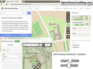
OpenHistoricalMap tim waters - Topomancy / NYPL Lightning Talk
- 1. OOppeennHHiissttoorriiccaallMMaapp..oorrgg 19th Century Hunterston, Scotland start_date end_date
- 2. Combined - all times 2009 Also Historic OSM Data 2008 Roman Mainz OOppeennHHiissttoorriiccaallMMaapp..oorrgg
- 3. OSM Stack Renderd / Mapnik – date range filters Osm2pgsql – lua script to import in start_date and end_date Edition / viewing ID Editor – date filtering / time widget Dynamic tiles / caching. Vector tiles Community https://github.com/openhistoricalmap/ OSM OHM Mailing List http://wiki.openstreetmap.org/wiki/Open_Historical_Map leleaaththeerrwwoooodd.h.heerrookkuuaapppp.c.coomm// OOppeennHHiissttoorriiccaallMMaapp..oorrgg “OSM Way” Adhoc Do what works first start_date / end_date Imagery as source OSM vs GIS Crowd vs Establishment? start_date end_date