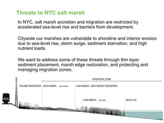
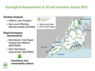
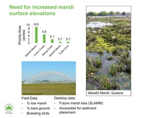
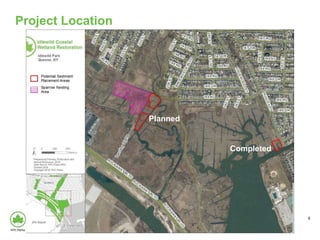
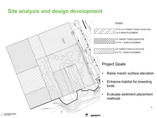
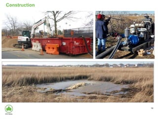
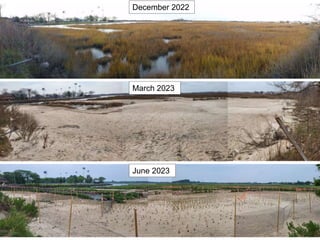
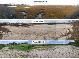
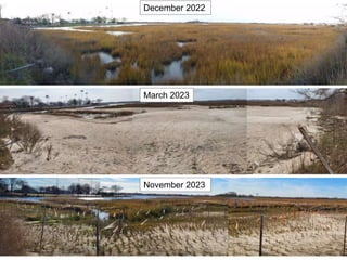
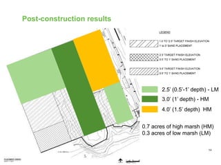
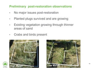
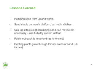
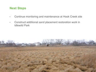
Thin Layer Sediment
Placement Salt Marsh
Restoration in Hook Creek
Park
November 30, 2023
Jamaica Bay Task Force
2
Almost Half of NYC is Green
3
Half of NYC’s Wetlands and Streams are in NYC Parks
Threats to NYC salt marsh
In NYC, salt marsh accretion and migration are restricted by
accelerated sea-level rise and barriers from development.
Citywide our marshes are vulnerable to shoreline and interior erosion
due to sea-level rise, storm surge, sediment starvation, and high
nutrient loads.
We want to address some of these threats through thin layer
sediment placement, marsh edge restoration, and protecting and
managing migration zones.
Ecological Assessment at 25 salt marshes across NYC
Long
Island
Sound
Staten
Island
Jamaica Bay
Desktop Analysis
o Historic Loss Analysis
o Sea Level Affecting
Marshes Model (SLAMM)
Rapid Ecological
Assessments
o Mid-Atlantic Tidal Rapid
Assessment Method
(MidTRAM)
o NAC Salt Marsh
Assessment (NACSMA)
Conditions and
vulnerability indices
Alley Creek Inner
Alley Creek Outer
Hutchinson Inner
Hutchinson Outer
Pelham Bay Cove
Pugsley Creek Marsh
Turtle Cove
Udall's Cove Marsh
Westchester Creek
Four Sparrow
Fresh Creek Marsh
Idlewild Marsh Inner
Idlewild Marsh Outer
Spring Creek
Arlington Marsh
Fresh Kills Marsh
Lemon Creek Inner
Lemon Creek Outer
Neck Creek Inner
Neck Creek Outer
Richmond Creek
Saw Mill Creek Inner Saw Mill Creek Outer
W. T. Davis Inner
W. T. Davis Outer
-1
-0.8
-0.6
-0.4
-0.2
0
0.2
0.4
0.6
0.8
-1.5 -1 -0.5 0 0.5 1 1.5 2
Long Island Sound
Jamaica Bay
Staten Island
Lower Condition / Lower Vulnerability Lower Condition / Higher Vulnerability
Higher Condition / Lower Vulnerability Higher Condition / Higher Vulnerability
Priority site for
protection
Priority site for restoration
Condition
Vulnerability
Need for increased marsh
surface elevations
8.9
4.8
2.1
0.7 0.7
0
2
4
6
8
10
Priority
Area
(acres)
Field Data
• % low marsh
• % bare ground
• Breeding birds
Desktop data:
• Future marsh loss (SLAMM)
• Accessible for sediment
placement
Photo: Patty Doer, TNC-NJ Idlewild Marsh, Queens
Project Location
8
Completed
Planned
Site analysis and design development
9
Project Goals
• Raise marsh surface elevation
• Enhance habitat for breeding
birds
• Evaluate sediment placement
methods
10
Construction
11
December 2022
March 2023
June 2023
12
December 2022
March 2023
August 2023
13
December 2022
March 2023
November 2023
Post-construction results
14
2.5’ (0.5’-1’ depth) - LM
3.0’ (1’ depth) - HM
4.0’ (1.5’ depth) HM
0.7 acres of high marsh (HM)
0.3 acres of low marsh (LM)
Preliminary post-restoration observations
• No major issues post-restoration
• Planted plugs survived and are growing
• Existing vegetation growing through thinner
areas of sand
• Crabs and birds present
15
High Marsh Low Marsh
2.3
1.5
3.1
2.0
2.2
1.6
3.1
2.0
3.0
2.3
3.2
2.1
0.0
0.5
1.0
1.5
2.0
2.5
3.0
3.5
4.0
RestoredHM RestoredLM ReferenceHM ReferenceLM
2023
Post-restoration
Average
Plot
Elevation
(ft
NAVD88)
2021 2022 2023 MHW MHHW
Post-restoration monitoring results
16
2.3
1.5
3.1
2.0
2.2
1.6
3.1
2.0
3.0
2.3
3.2
2.1
0.0
0.5
1.0
1.5
2.0
2.5
3.0
3.5
4.0
RestoredHM RestoredLM ReferenceHM ReferenceLM
2023
Post-restoration
Average
Plot
Elevation
(ft
NAVD88)
2021 2022 2023 MHW MHHW
Post-restoration monitoring results
17
Lessons Learned
• Pumping sand from upland works
• Sand stable on marsh platform, but not in ditches
• Coir log effective at containing sand, but maybe not
necessary – use turbidity curtain instead
• Public outreach is important (as is fencing)
• Existing plants grew through thinner areas of sand (~6
inches)
18
Next Steps
• Continue monitoring and maintenance at Hook Creek site
• Construct additional sand placement restoration work in
Idlewild Park
19
Thank you!
christopher.haight@parks.nyc.gov
Christopher Haight

NYCParks_HookCreekSedimentPlacement_20231130_FINAL.pptx

  • 1.
    Thin Layer Sediment PlacementSalt Marsh Restoration in Hook Creek Park November 30, 2023 Jamaica Bay Task Force
  • 2.
    2 Almost Half ofNYC is Green
  • 3.
    3 Half of NYC’sWetlands and Streams are in NYC Parks
  • 4.
    Threats to NYCsalt marsh In NYC, salt marsh accretion and migration are restricted by accelerated sea-level rise and barriers from development. Citywide our marshes are vulnerable to shoreline and interior erosion due to sea-level rise, storm surge, sediment starvation, and high nutrient loads. We want to address some of these threats through thin layer sediment placement, marsh edge restoration, and protecting and managing migration zones.
  • 5.
    Ecological Assessment at25 salt marshes across NYC Long Island Sound Staten Island Jamaica Bay Desktop Analysis o Historic Loss Analysis o Sea Level Affecting Marshes Model (SLAMM) Rapid Ecological Assessments o Mid-Atlantic Tidal Rapid Assessment Method (MidTRAM) o NAC Salt Marsh Assessment (NACSMA) Conditions and vulnerability indices
  • 6.
    Alley Creek Inner AlleyCreek Outer Hutchinson Inner Hutchinson Outer Pelham Bay Cove Pugsley Creek Marsh Turtle Cove Udall's Cove Marsh Westchester Creek Four Sparrow Fresh Creek Marsh Idlewild Marsh Inner Idlewild Marsh Outer Spring Creek Arlington Marsh Fresh Kills Marsh Lemon Creek Inner Lemon Creek Outer Neck Creek Inner Neck Creek Outer Richmond Creek Saw Mill Creek Inner Saw Mill Creek Outer W. T. Davis Inner W. T. Davis Outer -1 -0.8 -0.6 -0.4 -0.2 0 0.2 0.4 0.6 0.8 -1.5 -1 -0.5 0 0.5 1 1.5 2 Long Island Sound Jamaica Bay Staten Island Lower Condition / Lower Vulnerability Lower Condition / Higher Vulnerability Higher Condition / Lower Vulnerability Higher Condition / Higher Vulnerability Priority site for protection Priority site for restoration Condition Vulnerability
  • 7.
    Need for increasedmarsh surface elevations 8.9 4.8 2.1 0.7 0.7 0 2 4 6 8 10 Priority Area (acres) Field Data • % low marsh • % bare ground • Breeding birds Desktop data: • Future marsh loss (SLAMM) • Accessible for sediment placement Photo: Patty Doer, TNC-NJ Idlewild Marsh, Queens
  • 8.
  • 9.
    Site analysis anddesign development 9 Project Goals • Raise marsh surface elevation • Enhance habitat for breeding birds • Evaluate sediment placement methods
  • 10.
  • 11.
  • 12.
  • 13.
  • 14.
    Post-construction results 14 2.5’ (0.5’-1’depth) - LM 3.0’ (1’ depth) - HM 4.0’ (1.5’ depth) HM 0.7 acres of high marsh (HM) 0.3 acres of low marsh (LM)
  • 15.
    Preliminary post-restoration observations •No major issues post-restoration • Planted plugs survived and are growing • Existing vegetation growing through thinner areas of sand • Crabs and birds present 15 High Marsh Low Marsh
  • 16.
    2.3 1.5 3.1 2.0 2.2 1.6 3.1 2.0 3.0 2.3 3.2 2.1 0.0 0.5 1.0 1.5 2.0 2.5 3.0 3.5 4.0 RestoredHM RestoredLM ReferenceHMReferenceLM 2023 Post-restoration Average Plot Elevation (ft NAVD88) 2021 2022 2023 MHW MHHW Post-restoration monitoring results 16
  • 17.
    2.3 1.5 3.1 2.0 2.2 1.6 3.1 2.0 3.0 2.3 3.2 2.1 0.0 0.5 1.0 1.5 2.0 2.5 3.0 3.5 4.0 RestoredHM RestoredLM ReferenceHMReferenceLM 2023 Post-restoration Average Plot Elevation (ft NAVD88) 2021 2022 2023 MHW MHHW Post-restoration monitoring results 17
  • 18.
    Lessons Learned • Pumpingsand from upland works • Sand stable on marsh platform, but not in ditches • Coir log effective at containing sand, but maybe not necessary – use turbidity curtain instead • Public outreach is important (as is fencing) • Existing plants grew through thinner areas of sand (~6 inches) 18
  • 19.
    Next Steps • Continuemonitoring and maintenance at Hook Creek site • Construct additional sand placement restoration work in Idlewild Park 19
  • 20.

Editor's Notes

  • #3 Almost half of NYC is green, 12% of which is natural area. These areas include forests, wetlands and grasslands. NAC Ecological Cover Type Map, 2014.
  • #4 We have in NYC saltwater and freshwater marshes and beaches and mudflats. We will focus on the coastal zones that are inundated twice daily by the tides. There are 2,080 acres of tidal wetlands under NYC Parks management.
  • #8 Priority area: 17 acres across 5 sites