Kane Aldridge presents a seminar from the second Water Wednesday entitled "Future options for the Lower Lakes." Kane Aldridge is a postdoctoral fellow with Water Research Centre with The Environment Institute at The University of Adelaide.
Limnological and Ecological sensitivity of Rwenzori mountain lakes (Uganda - DR Congo) to climate warming. Presented by Hilde Eggermont by "Perth II: Global Change and the World's Mountains" conference in Perth, Scotland in September 2010.
Earthqakes are dynamic laboratories for learning and catalysts for building capacity for disaster-intelligent & disaster-resilient communites. Presentation courtesy of Dr Walter Hays, Global Alliance for Disaster Reduction
The metropolitan area of Eastern Pima County Arizona is developing and implementing a Regional Optimization Master Plan (ROMP) as a $720 million program to modernize and upgrade the two major RWRD metropolitan treatment facilities. These modernizations will improve the water quality for recharge and reuse, develop a state of the art water quality laboratory, incorporate solar and rainwater harvesting features, and will help to develop habitat and birding features. The Pima County/Tucson team will present the ongoing collaboration with the water research scientists at the University of Arizona, Pima Association of Governments, Tucson Audubon Society and other community organizations to proudly transform these RWRD treatment facilities into a water-centric focus area for the region, capitalizing on the natural beauty of the Santa Cruz River and the award winning area of the Tucson Sweetwater Wetlands.
Presentation by Walter Vergara & Sebastian Scholz, The World Bank, at Forest Day 3, 13 December 2009, Copenhagen. Learning event "Landscape approaches to Adaptation and Mitigation"
Wetlands: Climate adaptation, mitigation and biodiversity protectionCIFOR-ICRAF
Presentation by Walter Vergara & Sebastian Scholz, LAC Climate Change Team, Worldbank
Landscape approaches to mitigation and adaptation, Forest Day 3
Sunday, 13 December 2009
Copenhagen, Denmark
CLIMATE CHANGE, SEA-LEVEL RISE and COASTAL GEOLOGIC HAZARDSriseagrant
CLIMATE CHANGE, SEA-LEVEL RISE
and
COASTAL GEOLOGIC HAZARDS
URI Climate Change Symposium
5 May 2011
Jon C. Boothroyd
Rhode Island State Geologist,
Research Professor Emeritus – Quaternary Geology
-------------
Rhode Island Geological Survey and Department of Geosciences
College of the Environment and Life Sciences
University of Rhode Island
jon_boothroyd@uri.edu
Mapping Tools to Support Protected Area Managementreo-southamerica
• Bathymetry
• Biological and habitat information
• Management zones
• Oil and gas activities
• Oceanographic data
• Remotely-operated vehicle tracks
• Underwater photographs
Details proposed island restoration in the Upper Mississippi as part of an ecologically sustainable, multifunctional riverfront park design.
TLS/KVA presentation, prepared with Kestrel Design Group, InterFluve and Barr Engineering, and given to the Minnesota Department of Natural Resources and U.S. Army Corps of Engineers.
DNR and USACE are regulatory agencies overseeing the RiverFirst area.
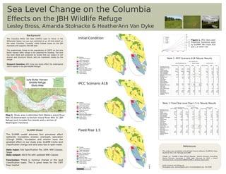
1. Background
The Columbia White Tail Deer (CWTD) used to thrive in the Initial Condition Figure 1. IPCC Sea Level
Willamette Valley, but are now restricted to an 18 mile extent on
Prediction Scenarios used
the lower Columbia. Currently viable habitat exists on the JBH
by SLAMM. We chose A1B
mainland and supports 150-200 deer.
and 1.5 meter rise.
The predominate threat to the populations of CWTD on the Julia
Butler Hansen (JBH) refuge is the potential for flooding. The land
has been diked and protected by levees that are subject to soil
erosion and structural failure, and are monitored closely by the Swamp
Inland Fresh Marsh Table 1. IPCC Scenario A1B Tabular Results
refuge. Tidal Fresh Marsh
Trans. Salt Marsh
Reg. Flooded Marsh
Research Question: Will rising sea levels affect the endangered Estuarine Beach
CWTD habitat in the JBH Wildlife Refuge? Tidal Flat
Riverine Tidal
Estuarine Open Water
Irreg. Flooded Marsh
Inland Shore
Tidal Swamp
IPCC Scenario A1B
Swamp
Inland Fresh Marsh
Table 2. Fixed Sea Level Rise 1.5 m Tabular Results
Tidal Fresh Marsh
Trans. Salt Marsh
Reg. Flooded Marsh
Estuarine Beach
Tidal Flat
Riverine Tidal
Estuarine Open Water
Map 1. Study area is delimited from Wallace Island River Irreg. Flooded Marsh
Mile 50 downstream to Karlson Island River Mile 32. JBH Inland Shore
Tidal Swamp
Refuge land includes five islands and a section of
Washington mainland.
SLAMM Model Fixed Rise 1.5
The SLAMM model assumes four processes affect
wetlands: inundation, erosion, overwash, saturation
(Clough 2009). Inundation and erosion have the
greatest effect on our study area. SLAMM tracks land
classification change and land area lost to open water.
Swamp
References
Inland Fresh Marsh
Data input: Site Specification file, DEM, NWI Classes, Tidal Fresh Marsh
Trans. Salt Marsh
This project was completed using all Open Source software: SLAMM 6.0 beta,
Slope Reg. Flooded Marsh Quantum GIS 1.4.0, Inkscape and GIMP.
Data output: ASCII file with updated NWI Classes Estuarine Beach
Tidal Flat Clough, J.S. "SLAMM 6 beta Official Release." Warren Pinnacle Consulting.
Riverine Tidal
Warren Pinnacle, December 1, 2009. Web. February 16, 2010. < http://
Estuarine Open Water
Conclusion: There is minimal change in the land Irreg. Flooded Marsh warrenpinnacle.com/prof/SLAMM6/SLAMM_6_Release_Notes.pdf>.
Inland Shore
classification types. This is great news for the CWT Tidal Swamp
Deer habitat. Poster Analysis and Design by:
0 1000 2000 Meters lbross@pdx.edu, stolnack@pdx.edu & hvandyke@pdx.edu Fall 2009