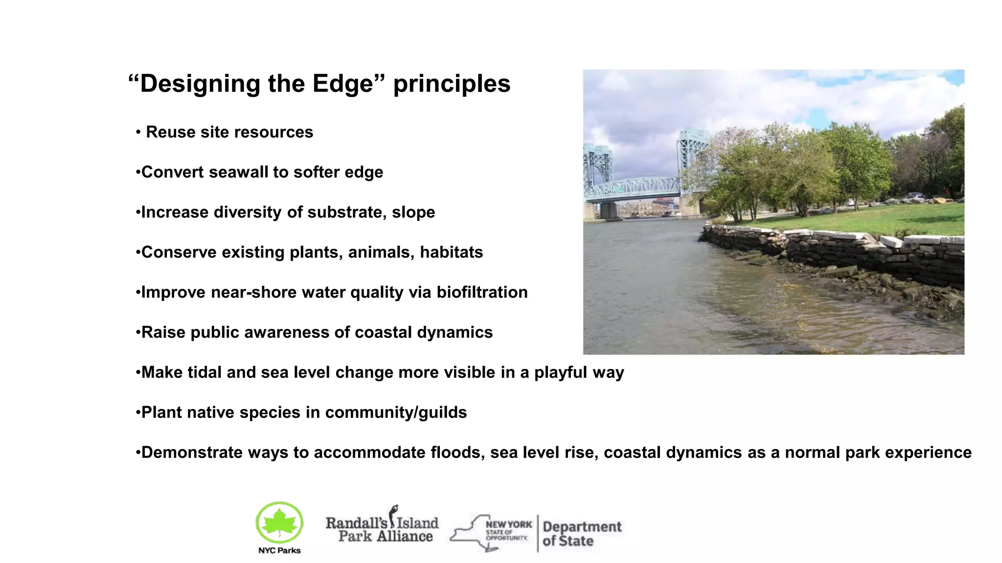
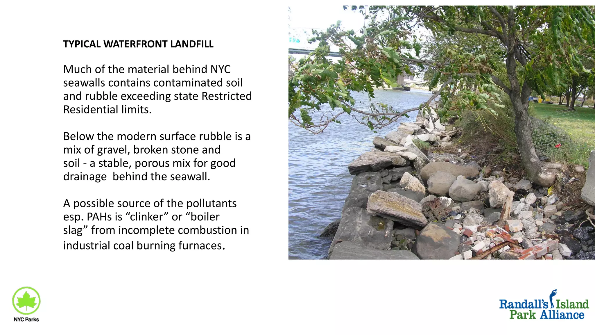
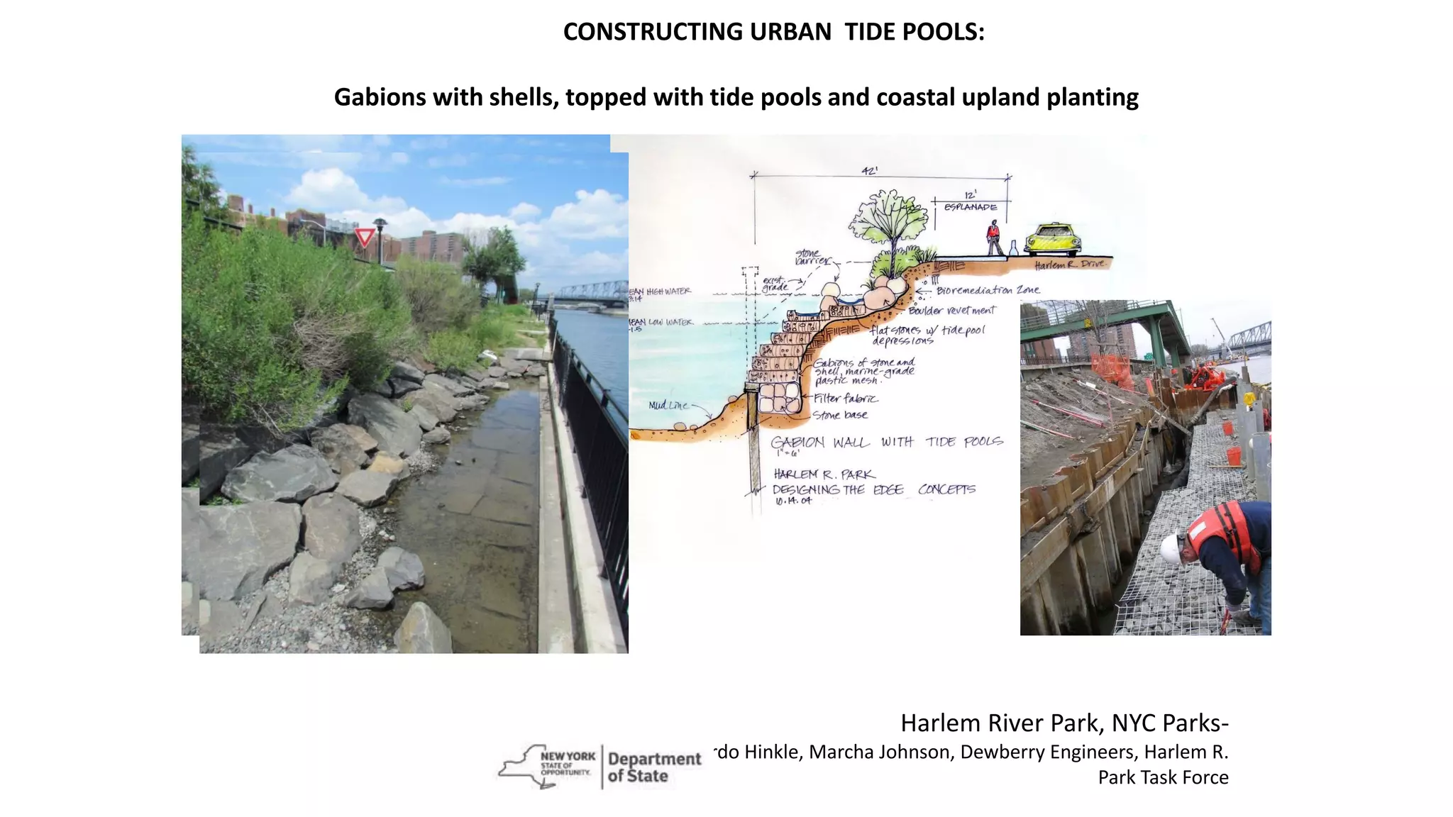
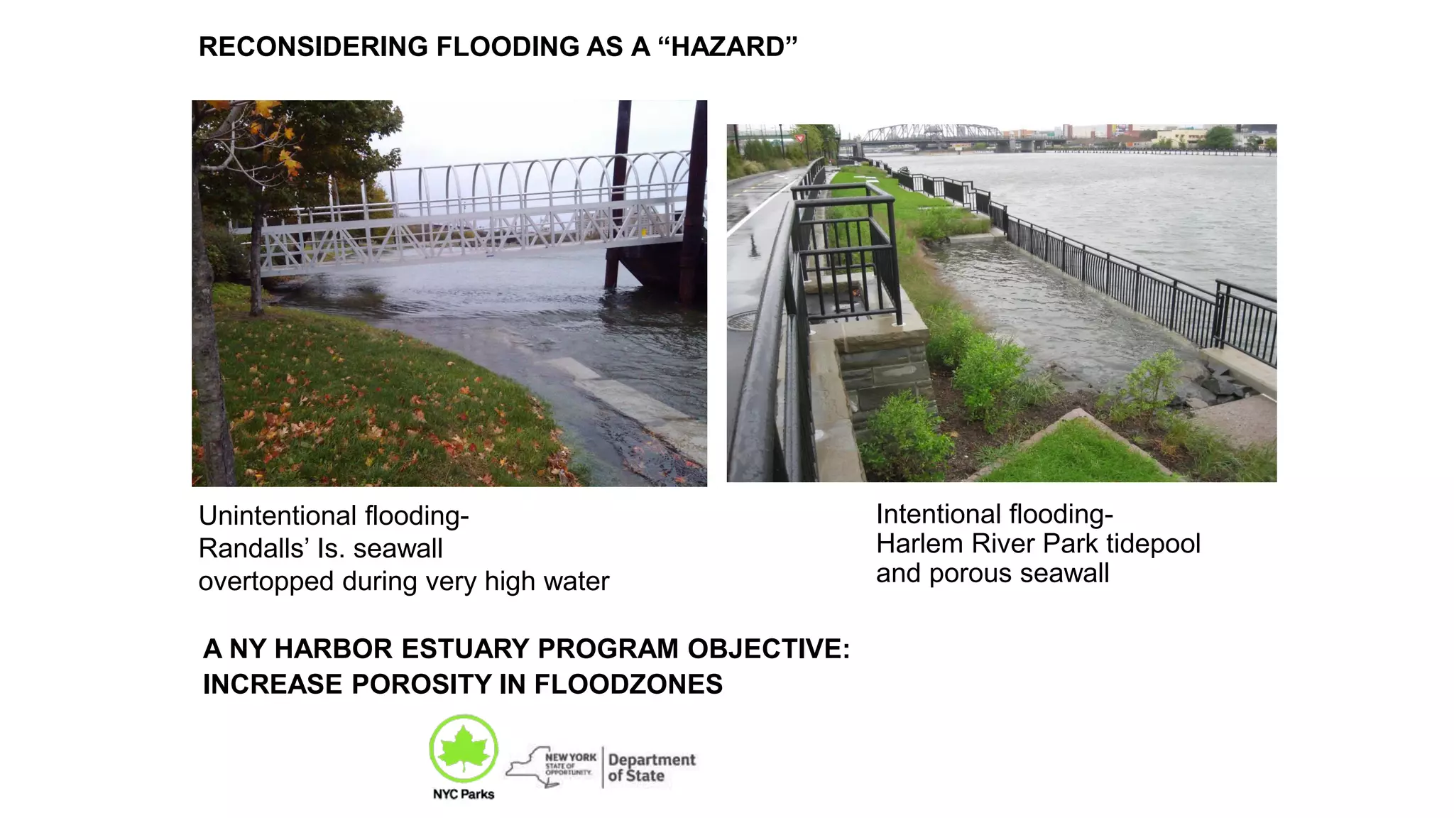
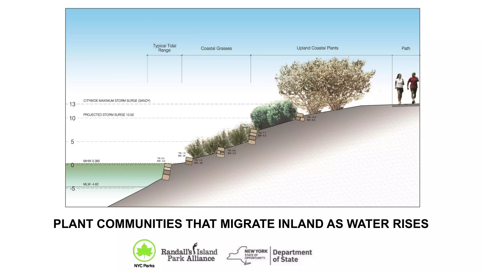
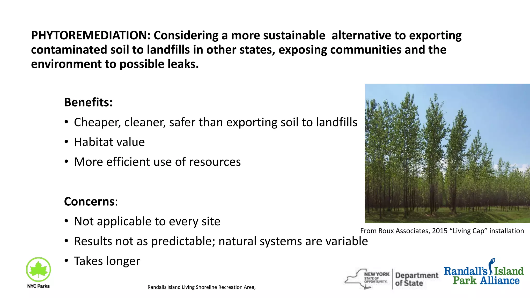
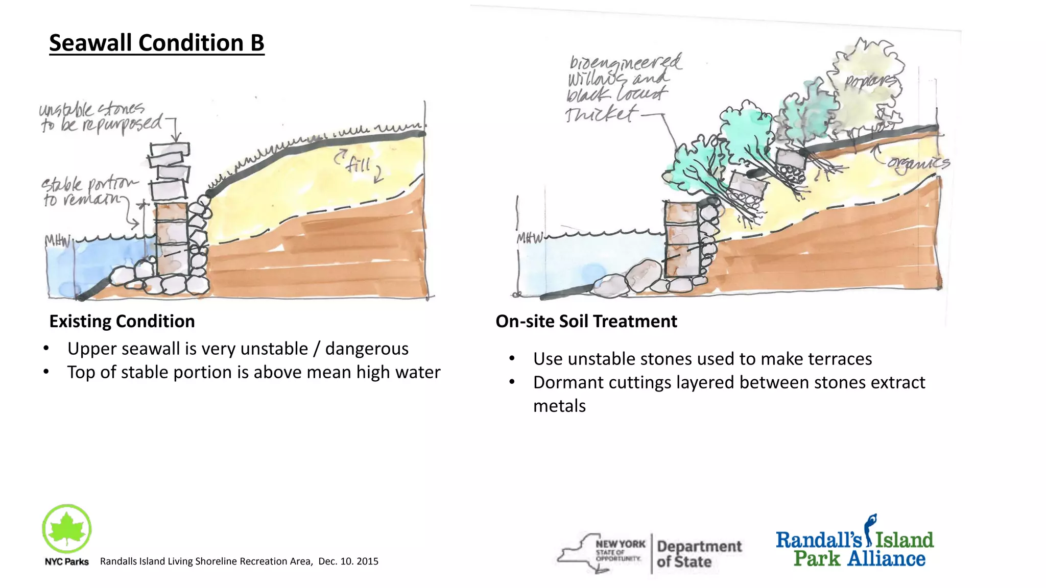
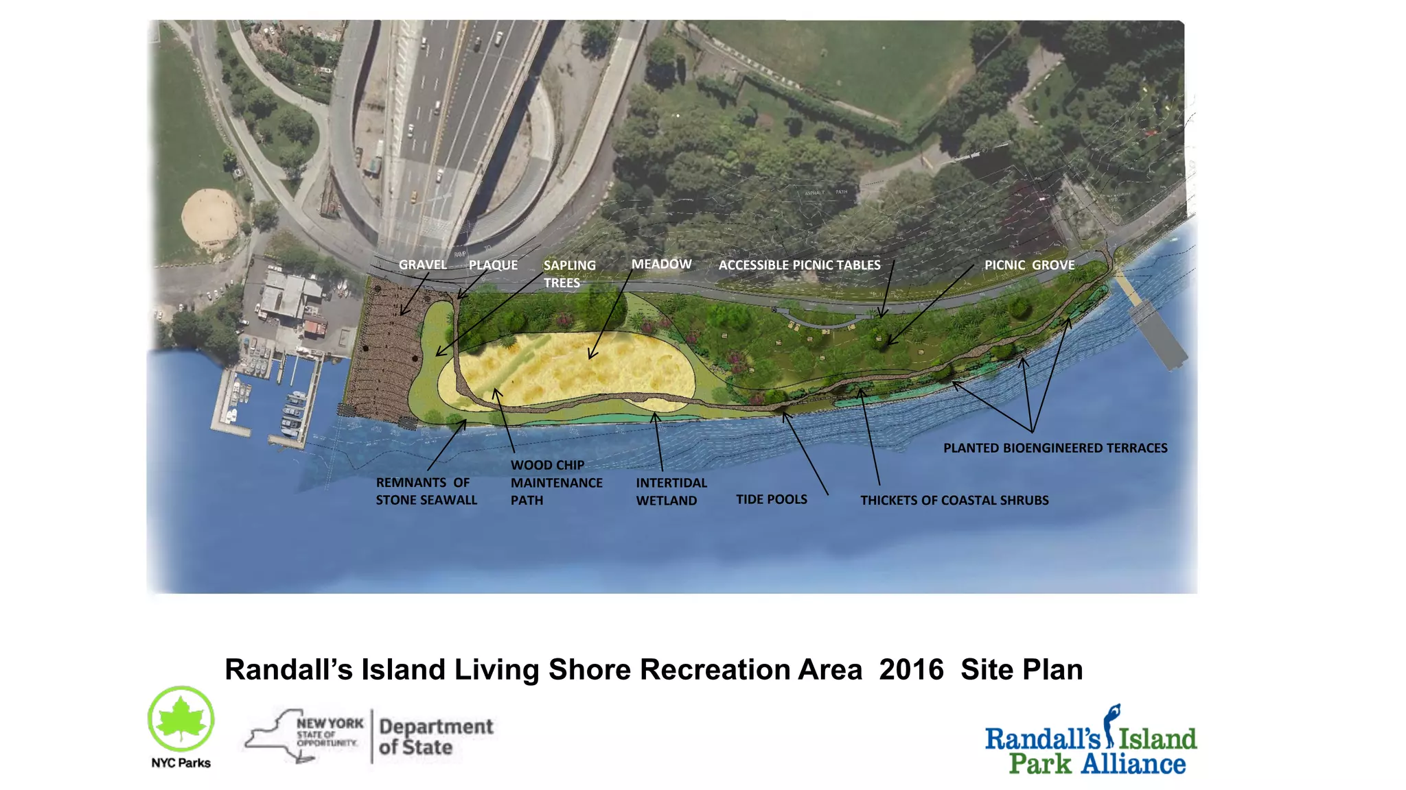
Coastal Landscapes:
Considerations for Healthier
Ecosystems
while Adapting to Change
Enterprise Community Partners
Rotterdam-NYC Roundtable on Urban Coastal Landscapes
Sept. 20, 2016
MORE RESILIENT, SUSTAINABLE COASTAL LANDSCAPES
can be located and designed to respect both human life and the life in
our adjacent ocean and estuarine ecosystems
Marcha Johnson, ASLA, PhD Landscape Archictect
and Ecological Restorationist, NYC Parks
Floodable coastal communities around
the world are growing; most of the
structures in these communities are
not able to easily tolerate changing
coastal conditions and water level.
Many coastal landscape and
engineering projects continue to
disregard the connection between
what we do on the shore and the
impact on life in the ocean.
LIVES AT STAKE
Barrier beach homes being raised and
moved inland
Hudson R. Park, NYC GoogleEarth.com
Irregular natural habitats contain a lot of variety and include changeable,
ephemeral patches. New methods, materials and arrangements are being
explored to enhance biodiversity on in-water structures, to offset some of their
habitat displacement impacts:
.
SURFACES AND STRUCTURES
In-water infrastructure is typically uniform in texture and straight; biodiversity
much lower than natural habitats. Even new, otherwise well-designed
structures often meet the water with biologically sterile materials.
Photo: Biodiversitysnapshots.net.au.
5
Athens, NY Greenwall
Photo by the designers: Anchor-QEA,
Seattle
Photo by the manufacturer: LI Precast,
GRADUAL RELEASE FROM HARD STRUCTURES - a few examples
Bulkheads which intercepted bluff
material feeding an eroding pocket
beach were removed at Seahurst
Park, in a Seattle suburb. After loss
of 4 vertical feet on the beach, it is
now rebuilding, restoring itself.Marsh grass boxes in Newtown Creek,
Sarah Durand, Carter Craft
RESPONSES TO TURBULENCE AND FLOODING:
• Zonation in response to gradients of light, wave exposure, etc.
• Moveable substrate
• Fractal arrangements, clustering,
• Conical, streamlined forms,
• Flexible, regenerating structures
• Complex surface textures
• Taking advantage of temporary pools
ANCIENT TECHNIQES
Some earlier North American coastal cultures adapted to rapid oscillations in sea level 4000 years ago:
• Raised surfaces of earth and shells.
• Seasonal settlements (summers at the beach, inland in winter)
• Flexibile, light, portable or temporary structures easily transported to higher ground
• Stacked elements adjustable in place
• Built to be easily replaceable with inexpensive, local materials
• Integrated with range of water level
Raised shell rings built
5- 20’ high, built 4000 years
ago in what is now coastal
salt marsh,
Georgia and S. Carolina
The Kincaid Site in Massac Co., Illinois,
showing platform mounds above floodstage.
Illustration by artist Herb Roe
THE NEW NORMAL OF INLAND MIGRATION:
Storms accelerate the inland shoreline movement during eras of sea level rise.
Photos: NYC Mayor’s office PLANYC
Beach 94th St: Dune developed
Before storm “Sandy” Oct. 2012 After storm. Sand moved from
beach inland onto lawns and streets
After storm “Sandy.” Sand added to
dune face; more of jetty is exposed
Beach 56th St. Remnant dune.
Before storm “Sandy” 2012
Project
Area
HARLEM R. AND RANDALL’S IS. LIVING SHORE
Queens
Manhattan
Bronx
New
Jersey
Project
Area
Harlem R. Park
Randall’s Is.
Living Shore
Funded with Dept. of State Coastal Resources grants for
research + capital project -- demonstrating innovative,
sustainable waterfront design
• Reuse site resources
•Convert seawall to softer edge
•Increase diversity of substrate, slope
•Conserve existing plants, animals, habitats
•Improve near-shore water quality via biofiltration
•Raise public awareness of coastal dynamics
•Make tidal and sea level change more visible in a playful way
•Plant native species in community/guilds
•Demonstrate ways to accommodate floods, sea level rise, coastal dynamics as a normal park experience
“Designing the Edge” principles
Much of the material behind NYC
seawalls contains contaminated soil
and rubble exceeding state Restricted
Residential limits.
Below the modern surface rubble is a
mix of gravel, broken stone and
soil - a stable, porous mix for good
drainage behind the seawall.
A possible source of the pollutants
esp. PAHs is “clinker” or “boiler
slag” from incomplete combustion in
industrial coal burning furnaces.
TYPICAL WATERFRONT LANDFILL
DESIGNING THE EDGE at HARLEM RIVER PARK - Replacing some natural floodplain functions.
Harlem R. Park 2011, 2013, 2015
Harlem R. at MacCombs Dam,
ca. 1865 Currier & Ives print
•Flood storage capacity
•Ecological connections
•Wave absorption instead of reflection.
•Resistance to rust, scour, salt corrosion
•Self-repairing
HARLEM RIVER PARK, completed 2009
SOFTENING ARMORED SHORES :
FLOODPLAIN TERRACES
POROUS SEAWALL
SHELLFISH-ATTRACTING MATERIALS
SET-BACKS TO SLOW LAMINAR FLOW,
Photo: Ricardo Hinkle, NYCParks
MIX OF EDGE CONDITIONS
photo: Fred Landa, NY DOS 2008
CONSTRUCTING URBAN TIDE POOLS:
Gabions with shells, topped with tide pools and coastal upland planting
Harlem River Park, NYC Parks-
Ricardo Hinkle, Marcha Johnson, Dewberry Engineers, Harlem R.
Park Task Force
Intentional flooding-
Harlem River Park tidepool
and porous seawall
A NY HARBOR ESTUARY PROGRAM OBJECTIVE:
INCREASE POROSITY IN FLOODZONES
Unintentional flooding-
Randalls’ Is. seawall
overtopped during very high water
RECONSIDERING FLOODING AS A “HAZARD”
Progressive water levels:
Elevations 5’ and 7’ above existing Mean High Water
MAKING SEA LEVEL RISE PART OF THE PARK
2015 Design for an Adaptable Edge- Randalls Is.
Remnant of old seawall
and toe stones
Berm constructed to “feed” the beach and
stabilize itself by adjusting slope
Vegetation can migrate in relation to water level
and open soil.
Surface of new beach face
PLANT COMMUNITIES THAT MIGRATE INLAND AS WATER RISES
11
ACCESSIBLE PICNIC TABLES
FLOOD PLAIN TERRACES
BEACH
PEDESTRIAN ACCESS
TO BEACH
BRIDGE STORMWATER
INFILTRATION
BANK RUN GRAVEL
PATH
PLAQUE
REMNANTS OF
STONE SEAWALL
BERM
GRAVEL
PARKING (13
SPACES)
HEADWALLS TIDE POOLS
BOULDER EDGE
PEDESTRIAN
ACCESS TO
WATER EDGE
PICNIC GROVE
Proposed 2015 Changes:
Remove upper part of crumbling seawall, reuse stone on site
Improve water edge access, mark water elevations
Public parking area
Cusp beach, berm, terraced slope, tidepools, headland features
Environmental education/citizen science features
Connect planted zones based on coastal ecological communities
DEC-Solid Waste Concerns:
Reusing soil contaminated with Lead, Mercury, PAHs
Stockpiling soil for other Randalls Island projects
New beach would be dynamic
Beach surface could have contaminants similar to
present surface but more mobile
Randall’s Island Living Shoreline Recreation Area, Dec. 10. 2015
PHYTOREMEDIATION: Considering a more sustainable alternative to exporting
contaminated soil to landfills in other states, exposing communities and the
environment to possible leaks.
Benefits:
• Cheaper, cleaner, safer than exporting soil to landfills
• Habitat value
• More efficient use of resources
Concerns:
• Not applicable to every site
• Results not as predictable; natural systems are variable
• Takes longer
Randalls Island Living Shoreline Recreation Area,
From Roux Associates, 2015 “Living Cap” installation
Graphics from: Phyto, by Kate Kennan, Niall Kirkwood, 2015 p. 36-37.
3 Phyto Methods:
Rhizodegradation:
PAH molecules are broken down into
benign compounds by soil bacteria in
root zone.
Phytodegradation:
Contaminants are degraded
into benign compounds by
plants.
Phytoextraction:
Plant concentrates metals in its leaves
or other tissues.
Randall’s Island Living Shoreline Recreation Area, Dec. 10. 2015
Seawall Condition B
Existing Condition On-site Soil Treatment
• Upper seawall is very unstable / dangerous
• Top of stable portion is above mean high water
• Use unstable stones used to make terraces
• Dormant cuttings layered between stones extract
metals
Randalls Island Living Shoreline Recreation Area, Dec. 10. 2015
Switchgrass, Panicum virgatum
Black Willow, Salix nigra
Black Locust, Robinia pseudoacacia,
Red Mulberry, Morus rubra
Randall’s Island Living Shoreline Recreation Area, Dec. 10. 2015
Build current design
Temporary seeding
Plants that extract MercuryPlants that degrade PAHs
Red Maple, Acer rubrum
Willow, Salix spp.
Plants that extract Lead
Sunflower, Helianthus annuus
Red maple, Acer rubrum
Honeylocust, Gleditsia triacanthos
Sources: Kennan and Kirkwood, Phyto, 2015; Southwesternurbanhydrology, 2015,
EPA https://clu-in.org/download/studentpapers/henry.pdf, 2001
Reduced scope - minimal grading - allowed project to go forward.
Trade-off: fewer public benefits.
Randall’s Island Living Shoreline Recreation Area, Dec. 10. 2015
Build current design
Intertidal pockets
Leave
as is
Meadow grasses and Trees Build picnic area per
2015 design
Woody phytoremediation thickets
ACCESSIBLE PICNIC TABLES
PLANTED BIOENGINEERED TERRACES
PLAQUE
REMNANTS OF
STONE SEAWALL
GRAVEL
TIDE POOLS
MEADOW PICNIC GROVE
Randall’s Island Living Shore Recreation Area 2016 Site Plan
INTERTIDAL
WETLAND THICKETS OF COASTAL SHRUBS
SAPLING
TREES
WOOD CHIP
MAINTENANCE
PATH
CONSTRAINTS, OPPORTUNITIES AND “BEST PRACTICES” FOR
CONTAMINATED SOIL MANAGEMENT
• Common urban soil contaminants add to cumulative public health burden
• Most of our waterfront contains fill, typically not clean materials, variable across a site
• The era of cheap, easy of disposal in leaky, local, open pits and piles is over
• Using 20th C. rules and methods for 21st C. problems is costly, expands environmental
impacts, potentially exposes many more citizens to harm
• Managing contaminated soil on-site is complex: more sustainable, may in some cases be
safer, cheaper and environmentally sound, but take longer and requires new skill sets
and regulatory approaches
Marcha Johnson, ASLA, PhD Landscape
Archictect
and Ecological Restorationist, NYC Parks
(718) 760-6646
Marcha.johnson@parks.nyc.gov
This presentation was supported by NYC Parks, the NYS
Dept. of State with funds provided under Title 11 of the
Environmental Protection Fund,
Photo credits:
http://www.conservewildlifenj.org/species/spotlight/pinnipeds/ Harbor seal
http://www.fws.gov/northeast/pipingplover/overview.html
www.nydailynews.com
http://assets.nydailynews.com/polopoly_fs/1.1574111.1389357933!/img/httpI
mage/image.JPG_gen/derivatives/gallery_1200/toddmaisel-1847729.JPG
Coney Is. July
http://news.maryland.gov/dnr/2012/11/30/funding-available-to-help-coastal-
communities-prepare-for-natural-disasters/ Crisfield,MD Houses under
water, Sandy
http://news.nationalgeographic.com/news/special-features/2014/07/140725-
outer-banks-north-carolina-sea-level-rise-climate/ House being moved off a
beach in Outer Banks, NC
www.Busseltonjetty.com.au purple barnacles
www.alamy.com blue mussels on rocks at Gorran Haven, Cornwall
www.telegraph.co.uk Limpets nature’s tough guy revealed
Fig Island photos, S. Carolina Dept. Archives and History, 2007
http://www.sapelonerr.org/education-training/the-history-of-sapelo/
https://www.bamertseed.com/switchgrass/
https://en.wikipedia.org/wiki/Platform_mound#/media/File:
Chromesun_kincaid_site_01.jpg
http://www.arkive.org/horseshoe-crab/limulus-polyphemus/image-G8860.html
Monterrey, California tide pool Photo: www. Coastalcare.org

Coastal Landscapes and How they Must Adapt to Climate Change

  • 1.
    Coastal Landscapes: Considerations forHealthier Ecosystems while Adapting to Change Enterprise Community Partners Rotterdam-NYC Roundtable on Urban Coastal Landscapes Sept. 20, 2016
  • 2.
    MORE RESILIENT, SUSTAINABLECOASTAL LANDSCAPES can be located and designed to respect both human life and the life in our adjacent ocean and estuarine ecosystems Marcha Johnson, ASLA, PhD Landscape Archictect and Ecological Restorationist, NYC Parks
  • 3.
    Floodable coastal communitiesaround the world are growing; most of the structures in these communities are not able to easily tolerate changing coastal conditions and water level. Many coastal landscape and engineering projects continue to disregard the connection between what we do on the shore and the impact on life in the ocean. LIVES AT STAKE Barrier beach homes being raised and moved inland
  • 4.
    Hudson R. Park,NYC GoogleEarth.com Irregular natural habitats contain a lot of variety and include changeable, ephemeral patches. New methods, materials and arrangements are being explored to enhance biodiversity on in-water structures, to offset some of their habitat displacement impacts: . SURFACES AND STRUCTURES In-water infrastructure is typically uniform in texture and straight; biodiversity much lower than natural habitats. Even new, otherwise well-designed structures often meet the water with biologically sterile materials. Photo: Biodiversitysnapshots.net.au.
  • 5.
    5 Athens, NY Greenwall Photoby the designers: Anchor-QEA, Seattle Photo by the manufacturer: LI Precast, GRADUAL RELEASE FROM HARD STRUCTURES - a few examples Bulkheads which intercepted bluff material feeding an eroding pocket beach were removed at Seahurst Park, in a Seattle suburb. After loss of 4 vertical feet on the beach, it is now rebuilding, restoring itself.Marsh grass boxes in Newtown Creek, Sarah Durand, Carter Craft
  • 6.
    RESPONSES TO TURBULENCEAND FLOODING: • Zonation in response to gradients of light, wave exposure, etc. • Moveable substrate • Fractal arrangements, clustering, • Conical, streamlined forms, • Flexible, regenerating structures • Complex surface textures • Taking advantage of temporary pools
  • 7.
    ANCIENT TECHNIQES Some earlierNorth American coastal cultures adapted to rapid oscillations in sea level 4000 years ago: • Raised surfaces of earth and shells. • Seasonal settlements (summers at the beach, inland in winter) • Flexibile, light, portable or temporary structures easily transported to higher ground • Stacked elements adjustable in place • Built to be easily replaceable with inexpensive, local materials • Integrated with range of water level Raised shell rings built 5- 20’ high, built 4000 years ago in what is now coastal salt marsh, Georgia and S. Carolina The Kincaid Site in Massac Co., Illinois, showing platform mounds above floodstage. Illustration by artist Herb Roe
  • 8.
    THE NEW NORMALOF INLAND MIGRATION: Storms accelerate the inland shoreline movement during eras of sea level rise. Photos: NYC Mayor’s office PLANYC Beach 94th St: Dune developed Before storm “Sandy” Oct. 2012 After storm. Sand moved from beach inland onto lawns and streets After storm “Sandy.” Sand added to dune face; more of jetty is exposed Beach 56th St. Remnant dune. Before storm “Sandy” 2012
  • 9.
    Project Area HARLEM R. ANDRANDALL’S IS. LIVING SHORE Queens Manhattan Bronx New Jersey Project Area Harlem R. Park Randall’s Is. Living Shore Funded with Dept. of State Coastal Resources grants for research + capital project -- demonstrating innovative, sustainable waterfront design
  • 10.
    • Reuse siteresources •Convert seawall to softer edge •Increase diversity of substrate, slope •Conserve existing plants, animals, habitats •Improve near-shore water quality via biofiltration •Raise public awareness of coastal dynamics •Make tidal and sea level change more visible in a playful way •Plant native species in community/guilds •Demonstrate ways to accommodate floods, sea level rise, coastal dynamics as a normal park experience “Designing the Edge” principles
  • 11.
    Much of thematerial behind NYC seawalls contains contaminated soil and rubble exceeding state Restricted Residential limits. Below the modern surface rubble is a mix of gravel, broken stone and soil - a stable, porous mix for good drainage behind the seawall. A possible source of the pollutants esp. PAHs is “clinker” or “boiler slag” from incomplete combustion in industrial coal burning furnaces. TYPICAL WATERFRONT LANDFILL
  • 12.
    DESIGNING THE EDGEat HARLEM RIVER PARK - Replacing some natural floodplain functions. Harlem R. Park 2011, 2013, 2015 Harlem R. at MacCombs Dam, ca. 1865 Currier & Ives print •Flood storage capacity •Ecological connections •Wave absorption instead of reflection. •Resistance to rust, scour, salt corrosion •Self-repairing
  • 13.
    HARLEM RIVER PARK,completed 2009 SOFTENING ARMORED SHORES : FLOODPLAIN TERRACES POROUS SEAWALL SHELLFISH-ATTRACTING MATERIALS SET-BACKS TO SLOW LAMINAR FLOW, Photo: Ricardo Hinkle, NYCParks MIX OF EDGE CONDITIONS photo: Fred Landa, NY DOS 2008
  • 14.
    CONSTRUCTING URBAN TIDEPOOLS: Gabions with shells, topped with tide pools and coastal upland planting Harlem River Park, NYC Parks- Ricardo Hinkle, Marcha Johnson, Dewberry Engineers, Harlem R. Park Task Force
  • 15.
    Intentional flooding- Harlem RiverPark tidepool and porous seawall A NY HARBOR ESTUARY PROGRAM OBJECTIVE: INCREASE POROSITY IN FLOODZONES Unintentional flooding- Randalls’ Is. seawall overtopped during very high water RECONSIDERING FLOODING AS A “HAZARD”
  • 16.
    Progressive water levels: Elevations5’ and 7’ above existing Mean High Water MAKING SEA LEVEL RISE PART OF THE PARK
  • 17.
    2015 Design foran Adaptable Edge- Randalls Is. Remnant of old seawall and toe stones Berm constructed to “feed” the beach and stabilize itself by adjusting slope Vegetation can migrate in relation to water level and open soil. Surface of new beach face
  • 18.
    PLANT COMMUNITIES THATMIGRATE INLAND AS WATER RISES 11
  • 19.
    ACCESSIBLE PICNIC TABLES FLOODPLAIN TERRACES BEACH PEDESTRIAN ACCESS TO BEACH BRIDGE STORMWATER INFILTRATION BANK RUN GRAVEL PATH PLAQUE REMNANTS OF STONE SEAWALL BERM GRAVEL PARKING (13 SPACES) HEADWALLS TIDE POOLS BOULDER EDGE PEDESTRIAN ACCESS TO WATER EDGE PICNIC GROVE Proposed 2015 Changes: Remove upper part of crumbling seawall, reuse stone on site Improve water edge access, mark water elevations Public parking area Cusp beach, berm, terraced slope, tidepools, headland features Environmental education/citizen science features Connect planted zones based on coastal ecological communities DEC-Solid Waste Concerns: Reusing soil contaminated with Lead, Mercury, PAHs Stockpiling soil for other Randalls Island projects New beach would be dynamic Beach surface could have contaminants similar to present surface but more mobile Randall’s Island Living Shoreline Recreation Area, Dec. 10. 2015
  • 20.
    PHYTOREMEDIATION: Considering amore sustainable alternative to exporting contaminated soil to landfills in other states, exposing communities and the environment to possible leaks. Benefits: • Cheaper, cleaner, safer than exporting soil to landfills • Habitat value • More efficient use of resources Concerns: • Not applicable to every site • Results not as predictable; natural systems are variable • Takes longer Randalls Island Living Shoreline Recreation Area, From Roux Associates, 2015 “Living Cap” installation
  • 21.
    Graphics from: Phyto,by Kate Kennan, Niall Kirkwood, 2015 p. 36-37. 3 Phyto Methods: Rhizodegradation: PAH molecules are broken down into benign compounds by soil bacteria in root zone. Phytodegradation: Contaminants are degraded into benign compounds by plants. Phytoextraction: Plant concentrates metals in its leaves or other tissues. Randall’s Island Living Shoreline Recreation Area, Dec. 10. 2015
  • 22.
    Seawall Condition B ExistingCondition On-site Soil Treatment • Upper seawall is very unstable / dangerous • Top of stable portion is above mean high water • Use unstable stones used to make terraces • Dormant cuttings layered between stones extract metals Randalls Island Living Shoreline Recreation Area, Dec. 10. 2015
  • 23.
    Switchgrass, Panicum virgatum BlackWillow, Salix nigra Black Locust, Robinia pseudoacacia, Red Mulberry, Morus rubra Randall’s Island Living Shoreline Recreation Area, Dec. 10. 2015 Build current design Temporary seeding Plants that extract MercuryPlants that degrade PAHs Red Maple, Acer rubrum Willow, Salix spp. Plants that extract Lead Sunflower, Helianthus annuus Red maple, Acer rubrum Honeylocust, Gleditsia triacanthos Sources: Kennan and Kirkwood, Phyto, 2015; Southwesternurbanhydrology, 2015, EPA https://clu-in.org/download/studentpapers/henry.pdf, 2001
  • 24.
    Reduced scope -minimal grading - allowed project to go forward. Trade-off: fewer public benefits. Randall’s Island Living Shoreline Recreation Area, Dec. 10. 2015 Build current design Intertidal pockets Leave as is Meadow grasses and Trees Build picnic area per 2015 design Woody phytoremediation thickets
  • 25.
    ACCESSIBLE PICNIC TABLES PLANTEDBIOENGINEERED TERRACES PLAQUE REMNANTS OF STONE SEAWALL GRAVEL TIDE POOLS MEADOW PICNIC GROVE Randall’s Island Living Shore Recreation Area 2016 Site Plan INTERTIDAL WETLAND THICKETS OF COASTAL SHRUBS SAPLING TREES WOOD CHIP MAINTENANCE PATH
  • 26.
    CONSTRAINTS, OPPORTUNITIES AND“BEST PRACTICES” FOR CONTAMINATED SOIL MANAGEMENT • Common urban soil contaminants add to cumulative public health burden • Most of our waterfront contains fill, typically not clean materials, variable across a site • The era of cheap, easy of disposal in leaky, local, open pits and piles is over • Using 20th C. rules and methods for 21st C. problems is costly, expands environmental impacts, potentially exposes many more citizens to harm • Managing contaminated soil on-site is complex: more sustainable, may in some cases be safer, cheaper and environmentally sound, but take longer and requires new skill sets and regulatory approaches
  • 27.
    Marcha Johnson, ASLA,PhD Landscape Archictect and Ecological Restorationist, NYC Parks (718) 760-6646 Marcha.johnson@parks.nyc.gov This presentation was supported by NYC Parks, the NYS Dept. of State with funds provided under Title 11 of the Environmental Protection Fund,
  • 28.
    Photo credits: http://www.conservewildlifenj.org/species/spotlight/pinnipeds/ Harborseal http://www.fws.gov/northeast/pipingplover/overview.html www.nydailynews.com http://assets.nydailynews.com/polopoly_fs/1.1574111.1389357933!/img/httpI mage/image.JPG_gen/derivatives/gallery_1200/toddmaisel-1847729.JPG Coney Is. July http://news.maryland.gov/dnr/2012/11/30/funding-available-to-help-coastal- communities-prepare-for-natural-disasters/ Crisfield,MD Houses under water, Sandy http://news.nationalgeographic.com/news/special-features/2014/07/140725- outer-banks-north-carolina-sea-level-rise-climate/ House being moved off a beach in Outer Banks, NC www.Busseltonjetty.com.au purple barnacles www.alamy.com blue mussels on rocks at Gorran Haven, Cornwall www.telegraph.co.uk Limpets nature’s tough guy revealed Fig Island photos, S. Carolina Dept. Archives and History, 2007 http://www.sapelonerr.org/education-training/the-history-of-sapelo/ https://www.bamertseed.com/switchgrass/ https://en.wikipedia.org/wiki/Platform_mound#/media/File: Chromesun_kincaid_site_01.jpg http://www.arkive.org/horseshoe-crab/limulus-polyphemus/image-G8860.html Monterrey, California tide pool Photo: www. Coastalcare.org