NISAR NASA-ISRO Synthetic Aperture Radar (NISAR) Volcanic Hazards
•
0 likes•8 views

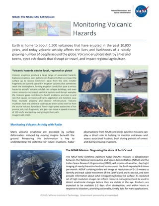
1) Radar observations from the NISAR satellite mission can help monitor volcanoes by measuring surface deformation caused by underground magma movement, which can indicate future eruptions. 2) Volcanic eruptions produce hazards like ash falls, lava and mudflows that can damage property and infrastructure as well as gases that harm health and the environment. 3) The NISAR mission will image nearly the entire land and ice masses of Earth with radar every 4-6 days at 5-10 meter resolution to track subtle changes and provide data for resource management and disaster response within hours.
![ã2017 California Institute of Technology. Government sponsorship acknowledged.
Continued from front page
Data from NISAR and other radar missions allow us to
identify and monitor surface deformation at quiescent
and active volcanoes through the use of radar
interferometry (InSAR). Only InSAR has the capability for
monitoring deformation at virtually all of the world’s
potentially active volcanoes on land. InSAR observations
allow us to build models of subsurface magma movement
preceding, accompanying, and following eruptions –
information that is critically important to understand the
state of activity and anticipated hazards. Radar images
that allow us to monitor and characterize volcanic
processes are also used to map the extent of eruptive
products, like lava and ash, during an eruption. When
combined with other measurements of volcanic activity,
data from NISAR will facilitate the development of more
realistic depictions of active volcanoes, which are critical
for eruption foresting.
All NISAR data products, including the InSAR results, will
be freely available through a web portal. This way, the
nation’s investment in land surveys remotely acquired
from space can be widely used by a variety of agencies and
individuals to monitor volcanic processes and mitigate
associated hazards.
National Aeronautics and Space Administration For more information, visit http://nisar.jpl.nasa.gov/applications
Jet Propulsion Laboratory / California Institute of Technology / Pasadena, California / www.jpl.nasa.gov
Map showing areas of volcanoes in the world
[Global Volcano Program/Smithsonian
Institution; US Center for Disease Control]
More than 50 volcanoes in the United States have erupted one or more times in
the past 200 years. The most volcanically active regions of the nation are in
Alaska, Hawaii, California, Oregon, Washington, and Wyoming. Unlike other
techniques that rely on measurements at a few points, InSAR produces a map of
ground deformation that covers a very large spatial area with centimeter- to
millimeter-scale accuracy, even over remote areas with no ground-based
monitoring resources. The figure to the right shows uplift (depicted as colored
fringes) of the Three Sisters Wilderness in Oregon during 1995-2001, which was
discovered by InSAR and would not otherwise have been known. The InSAR data
indicated the intrusion of about 20 million cubic meters of magma about 5 km
beneath the ground. The last eruption in this region was about 1500 years ago,
and there will certainly be another eruption in the area in the future. Advanced
knowledge of magma accumulation allowed for a better ground-based
monitoring network to be installed, and for better communication of potential
hazards to the local population. Image Credit: USGS
Monitoring Volcanoes with InSAR](data:image/gif;base64,R0lGODlhAQABAIAAAAAAAP///yH5BAEAAAAALAAAAAABAAEAAAIBRAA7)
Recommended
Recommended
More Related Content
Similar to NISAR NASA-ISRO Synthetic Aperture Radar (NISAR) Volcanic Hazards
Similar to NISAR NASA-ISRO Synthetic Aperture Radar (NISAR) Volcanic Hazards (20)
More from Dr. Pankaj Dhussa
More from Dr. Pankaj Dhussa (20)
Recently uploaded
Recently uploaded (20)
NISAR NASA-ISRO Synthetic Aperture Radar (NISAR) Volcanic Hazards
- 1. ã2017 California Institute of Technology. Government sponsorship acknowledged. NISAR: The NASA-ISRO SAR Mission Monitoring Volcanic Activity with Radar Many volcanic eruptions are preceded by surface deformation induced by moving magma beneath the ground. Measuring this deformation is key to understanding the potential for future eruptions. Radar observations from NISAR and other satellite missions can play a direct role in helping to monitor volcanoes and assess associated hazards, both during periods of unrest and during ensuing eruptions. Monitoring Volcanic Hazards Earth is home to about 1,500 volcanoes that have erupted in the past 10,000 years, and today volcanic activity affects the lives and livelihoods of a rapidly growing number of people around the globe. Volcanic eruptions destroy cities and towns, eject ash clouds that disrupt air travel, and impact regional agriculture. Volcanic hazards can be local, regional or global Volcanic eruptions produce a large range of associated hazards. Explosive eruptions eject ballistic rock fragments that can impact the surface up to several kilometers away from the vent. Smaller fragments are carried upward in eruption columns that sometimes reach the stratosphere, forming eruption clouds that pose a serious hazard to aircraft. Volcanic ash fall can collapse buildings, and even minor amounts can impact electrical systems and disrupt everyday life. Volcanic gases contribute to health problems, and also to acid rain that causes corrosion and harms vegetation and livestock. Lava flows inundate property and destroy infrastructure. Volcanic mudflows have the potential to devastate entire cities even far from the source volcano. Pyroclastic flows—high-speed avalanches of hot pumice, ash, rock fragments, and gas—can move at speeds in excess of 100 km/hr and destroy everything in their path. Image Credit: USGS The NISAR Mission: Diagnosing the state of Earth’s land The NASA–ISRO Synthetic Aperture Radar (NISAR) mission, a collaboration between the National Aeronautics and Space Administration (NASA) and the Indian Space Research Organization (ISRO), will provide all-weather, day/night imaging of nearly the entire land and ice masses of the Earth repeated 4-6 times per month. NISAR’s orbiting radars will image at resolutions of 5-10 meters to identify and track subtle movement of the Earth’s land and its sea ice, and even provide information about what is happening below the surface. Its repeated set of high resolution images can inform resource management and be used to detect small-scale changes before they are visible to the eye. Products are expected to be available 1-2 days after observation, and within hours in response to disasters, providing actionable, timely data for many applications.
- 2. ã2017 California Institute of Technology. Government sponsorship acknowledged. Continued from front page Data from NISAR and other radar missions allow us to identify and monitor surface deformation at quiescent and active volcanoes through the use of radar interferometry (InSAR). Only InSAR has the capability for monitoring deformation at virtually all of the world’s potentially active volcanoes on land. InSAR observations allow us to build models of subsurface magma movement preceding, accompanying, and following eruptions – information that is critically important to understand the state of activity and anticipated hazards. Radar images that allow us to monitor and characterize volcanic processes are also used to map the extent of eruptive products, like lava and ash, during an eruption. When combined with other measurements of volcanic activity, data from NISAR will facilitate the development of more realistic depictions of active volcanoes, which are critical for eruption foresting. All NISAR data products, including the InSAR results, will be freely available through a web portal. This way, the nation’s investment in land surveys remotely acquired from space can be widely used by a variety of agencies and individuals to monitor volcanic processes and mitigate associated hazards. National Aeronautics and Space Administration For more information, visit http://nisar.jpl.nasa.gov/applications Jet Propulsion Laboratory / California Institute of Technology / Pasadena, California / www.jpl.nasa.gov Map showing areas of volcanoes in the world [Global Volcano Program/Smithsonian Institution; US Center for Disease Control] More than 50 volcanoes in the United States have erupted one or more times in the past 200 years. The most volcanically active regions of the nation are in Alaska, Hawaii, California, Oregon, Washington, and Wyoming. Unlike other techniques that rely on measurements at a few points, InSAR produces a map of ground deformation that covers a very large spatial area with centimeter- to millimeter-scale accuracy, even over remote areas with no ground-based monitoring resources. The figure to the right shows uplift (depicted as colored fringes) of the Three Sisters Wilderness in Oregon during 1995-2001, which was discovered by InSAR and would not otherwise have been known. The InSAR data indicated the intrusion of about 20 million cubic meters of magma about 5 km beneath the ground. The last eruption in this region was about 1500 years ago, and there will certainly be another eruption in the area in the future. Advanced knowledge of magma accumulation allowed for a better ground-based monitoring network to be installed, and for better communication of potential hazards to the local population. Image Credit: USGS Monitoring Volcanoes with InSAR