1) Radar observations from the NISAR satellite mission can help monitor volcanoes by measuring surface deformation caused by underground magma movement, which can indicate future eruptions.
2) Volcanic eruptions produce hazards like ash falls, lava and mudflows that can damage property and infrastructure as well as gases that harm health and the environment.
3) The NISAR mission will image nearly the entire land and ice masses of Earth with radar every 4-6 days at 5-10 meter resolution to track subtle changes and provide data for resource management and disaster response within hours.
Disaster monitoring by multi-temporal images of the 2011 Tohoku Earthquake an...grssieee
PASCO analyzed data from satellites, aircraft, and vehicles after the 2011 Tohoku earthquake and tsunami to monitor the affected areas. Multi-source and multi-temporal data allowed automatic detection of inundation areas within hours of acquisition. Flood maps covering over 12,000 km2 were created from various satellite images and distributed to authorities for disaster management.
The NASA-ISRO SAR Mission (NISAR) will provide flood forecasting capabilities through the use of synthetic aperture radar (SAR) to measure changing water levels in flooded areas. NISAR will augment sparse networks of stream gauges by providing continuous maps of water level changes from SAR images. These maps can indicate how much water levels have increased or decreased between observations days or weeks apart. Flood forecasting from NISAR data can help save lives and property by informing communities of incoming floods and their expected severity.
The document discusses NOAA's National Environmental Satellite, Data, and Information Service (NESDIS) and its role in managing environmental satellites. NESDIS operates two types of satellites - polar-orbiting satellites that pass over the same location twice a day and provide global coverage every 12 hours, and geostationary satellites that remain fixed over one position and continuously monitor parts of Earth. The document also provides information about the Wallops Command and Data Acquisition Station, which supports many satellite missions, and gives an overview of the GOES-R series of geostationary satellites, which will provide improved weather monitoring, lightning detection, and space weather observations starting in 2017.
Spaceborne Imagery For Environmental & Disaster Monitoringgpetrie
The document discusses the use of spaceborne imagery for environmental and disaster monitoring. It provides examples of how satellite imagery has been used to monitor various natural disasters such as flooding, landslides, volcanic eruptions and forest fires. It also discusses how satellites are used to monitor ongoing environmental changes, such as receding glaciers, sand and dust storms, algal blooms, mining, agriculture and deforestation. Different types of satellites are used depending on the specific monitoring needs and situations.
Remote sensing involves collecting information about an object or area without physical contact using devices like satellites and aircraft. There are two main types: passive sensing which detects natural radiation like sunlight, and active sensing which emits energy like radar. The first weather satellite, TIROS-1, was launched in 1960 and used cameras to scan wide areas, revolutionizing remote sensing. Satellites provide an extended view of Earth and allow data collection in dangerous or inaccessible places without disturbing the environment. Remote sensing is used in fields like natural resource management and agriculture.
The document discusses several sustainability initiatives at NASA's Goddard Space Flight Center, including a tree planting event where approximately 250 native trees were planted by 20 Goddard employees. The event was part of GSFC's reforestation plan to add 40 acres of woodlands. Other sustainability programs mentioned include storm water management to filter pollutants and a wetlands mitigation program. The efforts are part of GSFC's broader sustainability program to be better environmental stewards.
This document discusses the role of remote sensing and GIS in disaster management. It begins with an introduction to disaster management cycles and then describes how remote sensing is used across different stages of disasters like cyclones, earthquakes, and floods for tasks such as early warning, damage assessment, and recovery planning. It provides examples of various satellites used for monitoring different disasters. The document emphasizes that while hazards cannot be prevented, remote sensing can play a key role in minimizing loss of life through preparedness, response, and rebuilding efforts after disasters strike.
The document discusses GEO Grid's activities during the 2011 Tohoku earthquake and tsunami in Japan, including providing satellite imagery, hazard maps, and geological data through online portals and services. It describes how GEO Grid established a disaster task force to process and deliver satellite data from NASA, JAXA, and other sources to support response and recovery efforts. Key services and data included satellite imagery of damage areas from ASTER, crustal deformation maps from PALSAR interferometry, and shaking maps from the QuiQuake system.
PPT Obstructs: Outline about Meteorological satellites and their types. principle of Satellite remote sensing - Electro Magnetic Spectrum, Data from weather satellites.
This document discusses how freely available weather and volcanic ash data from government agencies can be combined and visualized in near real-time using open web mapping services and tools. Specifically, it shows how data from NOAA and USGS on cloud cover, sulfur dioxide levels, and volcanic locations can be streamed and overlaid to track the dispersal of ash from the Eyjafjallajokull volcano in Iceland in 2010. Examples are given of viewing this "mash-up" of data on GIS Cloud and ArcGIS Explorer to monitor the movement of ash plumes and their impact on air travel.
NISAR
Earthquake! Tracking Location and Impact from Space
NASA
National Aeronautics and Space Administration
NASA-ISRO Synthetic Aperture Radar (NISAR)
By
Dr. Pankaj Dhussa
Satellite image processing involves correcting satellite images for defects, overlaying the 2D images onto a 3D model of Earth, and applying the images for scientific and practical uses. Early satellite photographs from the 1940s and 1950s provided initial images of Earth and the Moon. Modern satellite image processing utilizes large amounts of data from numerous sensors and satellites to monitor the planet. Cloud computing provides advanced infrastructure for processing large satellite images, performing corrections, and generating meaningful results through on-demand public and private cloud resources.
Use of satellite imageries in weather forecastingDK27497
Satellite imagery provides valuable data for weather forecasting. Meteorologists use satellite images, which act as "eyes in the sky", to observe the atmosphere and track events like the formation of clouds. Different types of satellites like geostationary and polar-orbiting satellites provide imagery at varying resolutions, frequencies, wavelengths, and angles. Weather forecasting involves collecting data from stations, analyzing patterns in satellite images and charts, and issuing forecasts. Satellite images allow forecasters to predict conditions and natural hazards. Continued technological advances will further improve forecasting accuracy.
Seminar report on GPS based Space Debris Removal SystemSunil Ds
Space debris refers to defunct objects in orbit around Earth, including spent rocket stages, old satellites, and fragments. As the number of satellites increases, space debris poses a hazard to operational spacecraft through collisions. Effective measures are needed to mitigate space debris, such as de-orbiting satellites at end-of-life and actively removing existing debris. The 2009 collision between an Iridium satellite and a Russian satellite created over 200,000 pieces of debris and challenged assumptions about collision risks. The US Space Surveillance Network tracks and catalogs artificial objects in orbit to monitor and predict space debris.
NOAA and NASA Launch New Polar Satellite for Next-Gen Weather ForecastingIrene_McNeil
The National Oceanic and Atmospheric Administration (NOAA) will transform the way we observe the earth’s climate and weather events following the launch of the Joint Polar Satellite System (JPSS-1). Launched by NASA for NOAA’s National Weather Service, the new satellite system will provide meteorologists and climate change researchers with more accurate weather predictions and a variety of high-definition observations of Earth.
Remote sensing is the collection of information about Earth's surface without direct contact. It uses sensors on satellites and aircraft to detect and measure electromagnetic radiation reflected or emitted from objects. There are two types of remote sensing - active uses sensors that emit energy like radar, while passive detects natural energy like sunlight. Applications include monitoring agriculture, forestry, geology, oceans, and the environment. NASA operates many satellites that use different parts of the electromagnetic spectrum to analyze features and changes on Earth.
Advanced earthquake monitoring techniques allow for more accurate earthquake detection and analysis. New monitoring stations have over 600 sensors installed. Shake maps can now be created for major cities to show seismic shaking. The 3D Full-Scale Earthquake Testing Facility in Japan will replicate large earthquakes to test building designs. Instrumenting buildings provides data to engineer earthquake-resistant structures. Improved monitoring through networks of sensors helps provide warning of impending shaking and tsunamis.
NASA Overcoming the 50-Year Ban History of the Ban on Commercial Supersonic F...Dr. Pankaj Dhussa
NASA
National Aeronautics and Space Administration
NASA Overcoming the 50-Year Ban
History of the Ban on Commercial Supersonic Flight Over Land
By
Dr. Pankaj Dhussa
More Related Content
Similar to NISAR NASA-ISRO Synthetic Aperture Radar (NISAR) Damage Mapping
Remote sensing involves collecting information about an object or area without physical contact using devices like satellites and aircraft. There are two main types: passive sensing which detects natural radiation like sunlight, and active sensing which emits energy like radar. The first weather satellite, TIROS-1, was launched in 1960 and used cameras to scan wide areas, revolutionizing remote sensing. Satellites provide an extended view of Earth and allow data collection in dangerous or inaccessible places without disturbing the environment. Remote sensing is used in fields like natural resource management and agriculture.
The document discusses several sustainability initiatives at NASA's Goddard Space Flight Center, including a tree planting event where approximately 250 native trees were planted by 20 Goddard employees. The event was part of GSFC's reforestation plan to add 40 acres of woodlands. Other sustainability programs mentioned include storm water management to filter pollutants and a wetlands mitigation program. The efforts are part of GSFC's broader sustainability program to be better environmental stewards.
This document discusses the role of remote sensing and GIS in disaster management. It begins with an introduction to disaster management cycles and then describes how remote sensing is used across different stages of disasters like cyclones, earthquakes, and floods for tasks such as early warning, damage assessment, and recovery planning. It provides examples of various satellites used for monitoring different disasters. The document emphasizes that while hazards cannot be prevented, remote sensing can play a key role in minimizing loss of life through preparedness, response, and rebuilding efforts after disasters strike.
The document discusses GEO Grid's activities during the 2011 Tohoku earthquake and tsunami in Japan, including providing satellite imagery, hazard maps, and geological data through online portals and services. It describes how GEO Grid established a disaster task force to process and deliver satellite data from NASA, JAXA, and other sources to support response and recovery efforts. Key services and data included satellite imagery of damage areas from ASTER, crustal deformation maps from PALSAR interferometry, and shaking maps from the QuiQuake system.
PPT Obstructs: Outline about Meteorological satellites and their types. principle of Satellite remote sensing - Electro Magnetic Spectrum, Data from weather satellites.
This document discusses how freely available weather and volcanic ash data from government agencies can be combined and visualized in near real-time using open web mapping services and tools. Specifically, it shows how data from NOAA and USGS on cloud cover, sulfur dioxide levels, and volcanic locations can be streamed and overlaid to track the dispersal of ash from the Eyjafjallajokull volcano in Iceland in 2010. Examples are given of viewing this "mash-up" of data on GIS Cloud and ArcGIS Explorer to monitor the movement of ash plumes and their impact on air travel.
NISAR
Earthquake! Tracking Location and Impact from Space
NASA
National Aeronautics and Space Administration
NASA-ISRO Synthetic Aperture Radar (NISAR)
By
Dr. Pankaj Dhussa
Satellite image processing involves correcting satellite images for defects, overlaying the 2D images onto a 3D model of Earth, and applying the images for scientific and practical uses. Early satellite photographs from the 1940s and 1950s provided initial images of Earth and the Moon. Modern satellite image processing utilizes large amounts of data from numerous sensors and satellites to monitor the planet. Cloud computing provides advanced infrastructure for processing large satellite images, performing corrections, and generating meaningful results through on-demand public and private cloud resources.
Use of satellite imageries in weather forecastingDK27497
Satellite imagery provides valuable data for weather forecasting. Meteorologists use satellite images, which act as "eyes in the sky", to observe the atmosphere and track events like the formation of clouds. Different types of satellites like geostationary and polar-orbiting satellites provide imagery at varying resolutions, frequencies, wavelengths, and angles. Weather forecasting involves collecting data from stations, analyzing patterns in satellite images and charts, and issuing forecasts. Satellite images allow forecasters to predict conditions and natural hazards. Continued technological advances will further improve forecasting accuracy.
Seminar report on GPS based Space Debris Removal SystemSunil Ds
Space debris refers to defunct objects in orbit around Earth, including spent rocket stages, old satellites, and fragments. As the number of satellites increases, space debris poses a hazard to operational spacecraft through collisions. Effective measures are needed to mitigate space debris, such as de-orbiting satellites at end-of-life and actively removing existing debris. The 2009 collision between an Iridium satellite and a Russian satellite created over 200,000 pieces of debris and challenged assumptions about collision risks. The US Space Surveillance Network tracks and catalogs artificial objects in orbit to monitor and predict space debris.
NOAA and NASA Launch New Polar Satellite for Next-Gen Weather ForecastingIrene_McNeil
The National Oceanic and Atmospheric Administration (NOAA) will transform the way we observe the earth’s climate and weather events following the launch of the Joint Polar Satellite System (JPSS-1). Launched by NASA for NOAA’s National Weather Service, the new satellite system will provide meteorologists and climate change researchers with more accurate weather predictions and a variety of high-definition observations of Earth.
Remote sensing is the collection of information about Earth's surface without direct contact. It uses sensors on satellites and aircraft to detect and measure electromagnetic radiation reflected or emitted from objects. There are two types of remote sensing - active uses sensors that emit energy like radar, while passive detects natural energy like sunlight. Applications include monitoring agriculture, forestry, geology, oceans, and the environment. NASA operates many satellites that use different parts of the electromagnetic spectrum to analyze features and changes on Earth.
Advanced earthquake monitoring techniques allow for more accurate earthquake detection and analysis. New monitoring stations have over 600 sensors installed. Shake maps can now be created for major cities to show seismic shaking. The 3D Full-Scale Earthquake Testing Facility in Japan will replicate large earthquakes to test building designs. Instrumenting buildings provides data to engineer earthquake-resistant structures. Improved monitoring through networks of sensors helps provide warning of impending shaking and tsunamis.
Similar to NISAR NASA-ISRO Synthetic Aperture Radar (NISAR) Damage Mapping (20)
NASA Overcoming the 50-Year Ban History of the Ban on Commercial Supersonic F...Dr. Pankaj Dhussa
NASA
National Aeronautics and Space Administration
NASA Overcoming the 50-Year Ban
History of the Ban on Commercial Supersonic Flight Over Land
By
Dr. Pankaj Dhussa
NASA Carbon Fiber Composites (CFC) Recycling Technology Enabled by the TuFF T...Dr. Pankaj Dhussa
NASA
National Aeronautics and Space Administration
NASA Carbon Fiber Composites (CFC) Recycling
Technology Enabled by the TuFF Technology
By
Dr. Pankaj Dhussa
NASA Urban Air Mobility Fatigue Prediction Aaron Crawford – NASA ULI Innovati...Dr. Pankaj Dhussa
NASA
National Aeronautics and Space Administration
NASA Urban Air Mobility Fatigue Prediction
Aaron Crawford – NASA ULI Innovative Manufacturing, Operation, and Certification of Advanced
By
Dr. Pankaj Dhussa
NASA
National Aeronautics and Space Administration
NASA Multiscale Analysis Tool (NASMAT)
Robust, Integrated, Physics-based, Non-linear, Variable Fidelity Modeling of
Multi-phased Materials and Structures
By
Dr. Pankaj Dhussa
NASA Aviary Open-source software tool for optimizing next-generation aircraft...Dr. Pankaj Dhussa
NASA
National Aeronautics and Space Administration
NASA Aviary
Open-source software tool for optimizing next-generation aircraft designs
By
Dr. Pankaj Dhussa
NASA Aircraft Certification by Analysis (CbA) 20-year Vision for Virtual Flig...Dr. Pankaj Dhussa
NASA
National Aeronautics and Space Administration
NASA Aircraft Certification by Analysis (CbA)
20-year Vision for Virtual Flight Testing
By
Dr. Pankaj Dhussa
NASA DECO CAS Research into a New Operating Mode for Digitally Enabled Cooper...Dr. Pankaj Dhussa
NASA
National Aeronautics and Space Administration
NASA DECO
CAS Research into a New Operating Mode for Digitally Enabled Cooperative Operations (DECO)
By
Dr. Pankaj Dhussa
NASA Advanced Exploration of Reliable Operation at low Altitudes: meteorology...Dr. Pankaj Dhussa
NASA
National Aeronautics and Space Administration
NASA Advanced Exploration of Reliable Operation at low Altitudes: meteorology, Simulation,
and Technology (AEROcAST)
By
Dr. Pankaj Dhussa
NASA Self-Adaptation of Loosely Coupled Systems across a System of Small Uncr...Dr. Pankaj Dhussa
NASA
National Aeronautics and Space Administration
NASA Self-Adaptation of Loosely Coupled Systems across a
System of Small Uncrewed Aerial Vehicles
By
Dr. Pankaj Dhussa
NASA RealWindDroneSim (RWDS) Enhancing Simulation Fidelity of small Uncrewed ...Dr. Pankaj Dhussa
NASA
National Aeronautics and Space Administration
NASA RealWindDroneSim (RWDS)
Enhancing Simulation Fidelity of small Uncrewed Aerial Vehicles in Windy Conditions
By
Dr. Pankaj Dhussa
NASA ARMD Test Data Portal (ATDP) Agile Development Method Introduction of an...Dr. Pankaj Dhussa
NASA
National Aeronautics and Space Administration
NASA ARMD Test Data Portal (ATDP) Agile Development Method
Introduction of an Agile Systems Engineering Process to the
NASA Armstrong Flight Research Center
By
Dr. Pankaj Dhussa
NASA ARMD Test Data Portal (ATDP) he ARMD Test Data Portal (ATDP) is a secure...Dr. Pankaj Dhussa
NASA
National Aeronautics and Space Administration
NASA The ARMD Test Data Portal (ATDP) is a secure data archive that allows NASA personnel to remotely upload and register ARMD test data, as well as to quickly search, access, extract, time slice, and download test data for further analysis.
Associated metadata [ATDP Metadata Specification (AMS)] is compliant with government and industry metadata standards and requirements, and provides capabilities for cataloging, search, and data discovery.
By
Dr. Pankaj Dhussa
HCL Notes and Domino License Cost Reduction in the World of DLAUpanagenda
Webinar Recording: https://www.panagenda.com/webinars/hcl-notes-and-domino-license-cost-reduction-in-the-world-of-dlau/
The introduction of DLAU and the CCB & CCX licensing model caused quite a stir in the HCL community. As a Notes and Domino customer, you may have faced challenges with unexpected user counts and license costs. You probably have questions on how this new licensing approach works and how to benefit from it. Most importantly, you likely have budget constraints and want to save money where possible. Don’t worry, we can help with all of this!
We’ll show you how to fix common misconfigurations that cause higher-than-expected user counts, and how to identify accounts which you can deactivate to save money. There are also frequent patterns that can cause unnecessary cost, like using a person document instead of a mail-in for shared mailboxes. We’ll provide examples and solutions for those as well. And naturally we’ll explain the new licensing model.
Join HCL Ambassador Marc Thomas in this webinar with a special guest appearance from Franz Walder. It will give you the tools and know-how to stay on top of what is going on with Domino licensing. You will be able lower your cost through an optimized configuration and keep it low going forward.
These topics will be covered
- Reducing license cost by finding and fixing misconfigurations and superfluous accounts
- How do CCB and CCX licenses really work?
- Understanding the DLAU tool and how to best utilize it
- Tips for common problem areas, like team mailboxes, functional/test users, etc
- Practical examples and best practices to implement right away
Fueling AI with Great Data with Airbyte WebinarZilliz
This talk will focus on how to collect data from a variety of sources, leveraging this data for RAG and other GenAI use cases, and finally charting your course to productionalization.
Monitoring and Managing Anomaly Detection on OpenShift.pdfTosin Akinosho
Monitoring and Managing Anomaly Detection on OpenShift
Overview
Dive into the world of anomaly detection on edge devices with our comprehensive hands-on tutorial. This SlideShare presentation will guide you through the entire process, from data collection and model training to edge deployment and real-time monitoring. Perfect for those looking to implement robust anomaly detection systems on resource-constrained IoT/edge devices.
Key Topics Covered
1. Introduction to Anomaly Detection
- Understand the fundamentals of anomaly detection and its importance in identifying unusual behavior or failures in systems.
2. Understanding Edge (IoT)
- Learn about edge computing and IoT, and how they enable real-time data processing and decision-making at the source.
3. What is ArgoCD?
- Discover ArgoCD, a declarative, GitOps continuous delivery tool for Kubernetes, and its role in deploying applications on edge devices.
4. Deployment Using ArgoCD for Edge Devices
- Step-by-step guide on deploying anomaly detection models on edge devices using ArgoCD.
5. Introduction to Apache Kafka and S3
- Explore Apache Kafka for real-time data streaming and Amazon S3 for scalable storage solutions.
6. Viewing Kafka Messages in the Data Lake
- Learn how to view and analyze Kafka messages stored in a data lake for better insights.
7. What is Prometheus?
- Get to know Prometheus, an open-source monitoring and alerting toolkit, and its application in monitoring edge devices.
8. Monitoring Application Metrics with Prometheus
- Detailed instructions on setting up Prometheus to monitor the performance and health of your anomaly detection system.
9. What is Camel K?
- Introduction to Camel K, a lightweight integration framework built on Apache Camel, designed for Kubernetes.
10. Configuring Camel K Integrations for Data Pipelines
- Learn how to configure Camel K for seamless data pipeline integrations in your anomaly detection workflow.
11. What is a Jupyter Notebook?
- Overview of Jupyter Notebooks, an open-source web application for creating and sharing documents with live code, equations, visualizations, and narrative text.
12. Jupyter Notebooks with Code Examples
- Hands-on examples and code snippets in Jupyter Notebooks to help you implement and test anomaly detection models.
Ocean lotus Threat actors project by John Sitima 2024 (1).pptxSitimaJohn
Ocean Lotus cyber threat actors represent a sophisticated, persistent, and politically motivated group that poses a significant risk to organizations and individuals in the Southeast Asian region. Their continuous evolution and adaptability underscore the need for robust cybersecurity measures and international cooperation to identify and mitigate the threats posed by such advanced persistent threat groups.
How to Interpret Trends in the Kalyan Rajdhani Mix Chart.pdfChart Kalyan
A Mix Chart displays historical data of numbers in a graphical or tabular form. The Kalyan Rajdhani Mix Chart specifically shows the results of a sequence of numbers over different periods.
A Comprehensive Guide to DeFi Development Services in 2024Intelisync
DeFi represents a paradigm shift in the financial industry. Instead of relying on traditional, centralized institutions like banks, DeFi leverages blockchain technology to create a decentralized network of financial services. This means that financial transactions can occur directly between parties, without intermediaries, using smart contracts on platforms like Ethereum.
In 2024, we are witnessing an explosion of new DeFi projects and protocols, each pushing the boundaries of what’s possible in finance.
In summary, DeFi in 2024 is not just a trend; it’s a revolution that democratizes finance, enhances security and transparency, and fosters continuous innovation. As we proceed through this presentation, we'll explore the various components and services of DeFi in detail, shedding light on how they are transforming the financial landscape.
At Intelisync, we specialize in providing comprehensive DeFi development services tailored to meet the unique needs of our clients. From smart contract development to dApp creation and security audits, we ensure that your DeFi project is built with innovation, security, and scalability in mind. Trust Intelisync to guide you through the intricate landscape of decentralized finance and unlock the full potential of blockchain technology.
Ready to take your DeFi project to the next level? Partner with Intelisync for expert DeFi development services today!
Building Production Ready Search Pipelines with Spark and MilvusZilliz
Spark is the widely used ETL tool for processing, indexing and ingesting data to serving stack for search. Milvus is the production-ready open-source vector database. In this talk we will show how to use Spark to process unstructured data to extract vector representations, and push the vectors to Milvus vector database for search serving.
Nunit vs XUnit vs MSTest Differences Between These Unit Testing Frameworks.pdfflufftailshop
When it comes to unit testing in the .NET ecosystem, developers have a wide range of options available. Among the most popular choices are NUnit, XUnit, and MSTest. These unit testing frameworks provide essential tools and features to help ensure the quality and reliability of code. However, understanding the differences between these frameworks is crucial for selecting the most suitable one for your projects.
Main news related to the CCS TSI 2023 (2023/1695)Jakub Marek
An English 🇬🇧 translation of a presentation to the speech I gave about the main changes brought by CCS TSI 2023 at the biggest Czech conference on Communications and signalling systems on Railways, which was held in Clarion Hotel Olomouc from 7th to 9th November 2023 (konferenceszt.cz). Attended by around 500 participants and 200 on-line followers.
The original Czech 🇨🇿 version of the presentation can be found here: https://www.slideshare.net/slideshow/hlavni-novinky-souvisejici-s-ccs-tsi-2023-2023-1695/269688092 .
The videorecording (in Czech) from the presentation is available here: https://youtu.be/WzjJWm4IyPk?si=SImb06tuXGb30BEH .
Let's Integrate MuleSoft RPA, COMPOSER, APM with AWS IDP along with Slackshyamraj55
Discover the seamless integration of RPA (Robotic Process Automation), COMPOSER, and APM with AWS IDP enhanced with Slack notifications. Explore how these technologies converge to streamline workflows, optimize performance, and ensure secure access, all while leveraging the power of AWS IDP and real-time communication via Slack notifications.
5th LF Energy Power Grid Model Meet-up SlidesDanBrown980551
5th Power Grid Model Meet-up
It is with great pleasure that we extend to you an invitation to the 5th Power Grid Model Meet-up, scheduled for 6th June 2024. This event will adopt a hybrid format, allowing participants to join us either through an online Mircosoft Teams session or in person at TU/e located at Den Dolech 2, Eindhoven, Netherlands. The meet-up will be hosted by Eindhoven University of Technology (TU/e), a research university specializing in engineering science & technology.
Power Grid Model
The global energy transition is placing new and unprecedented demands on Distribution System Operators (DSOs). Alongside upgrades to grid capacity, processes such as digitization, capacity optimization, and congestion management are becoming vital for delivering reliable services.
Power Grid Model is an open source project from Linux Foundation Energy and provides a calculation engine that is increasingly essential for DSOs. It offers a standards-based foundation enabling real-time power systems analysis, simulations of electrical power grids, and sophisticated what-if analysis. In addition, it enables in-depth studies and analysis of the electrical power grid’s behavior and performance. This comprehensive model incorporates essential factors such as power generation capacity, electrical losses, voltage levels, power flows, and system stability.
Power Grid Model is currently being applied in a wide variety of use cases, including grid planning, expansion, reliability, and congestion studies. It can also help in analyzing the impact of renewable energy integration, assessing the effects of disturbances or faults, and developing strategies for grid control and optimization.
What to expect
For the upcoming meetup we are organizing, we have an exciting lineup of activities planned:
-Insightful presentations covering two practical applications of the Power Grid Model.
-An update on the latest advancements in Power Grid -Model technology during the first and second quarters of 2024.
-An interactive brainstorming session to discuss and propose new feature requests.
-An opportunity to connect with fellow Power Grid Model enthusiasts and users.
Digital Marketing Trends in 2024 | Guide for Staying AheadWask
https://www.wask.co/ebooks/digital-marketing-trends-in-2024
Feeling lost in the digital marketing whirlwind of 2024? Technology is changing, consumer habits are evolving, and staying ahead of the curve feels like a never-ending pursuit. This e-book is your compass. Dive into actionable insights to handle the complexities of modern marketing. From hyper-personalization to the power of user-generated content, learn how to build long-term relationships with your audience and unlock the secrets to success in the ever-shifting digital landscape.
GraphRAG for Life Science to increase LLM accuracyTomaz Bratanic
GraphRAG for life science domain, where you retriever information from biomedical knowledge graphs using LLMs to increase the accuracy and performance of generated answers
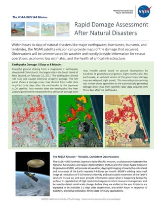
1. ã2019 California Institute of Technology. Government sponsorship acknowledged.
The NISAR-ISRO SAR Mission
Rapid Damage Assessment
After Natural Disasters
Within hours to days of natural disasters like major earthquakes, hurricanes, tsunamis, and
landslides, the NISAR satellite mission can provide maps of the damage that occurred.
Observations will be uninterrupted by weather and rapidly provide information for rescue
operations, economic loss estimates, and the health of critical infrastructure.
Earthquake Damage: 3 Days vs 8 Months
Powerful ground shaking from a magnitude 7 earthquake
devastated Christchurch, the largest city in the South Island of
New Zealand, on February 22, 2011. The earthquake claimed
185 lives and caused extensive property damage. The left
panel shows a damage proxy map derived from radar data
acquired three days after the earthquake by the Japanese
ALOS satellite. Four months after the earthquake, the New
Zealand government released the first version of damage zone
map (middle panel) based on ground observations by
hundreds of geotechnical engineers. Eight months after the
earthquake, an updated version of the government damage
map was released (right panel). This manually produced map
was in even closer agreement to the automatically generated
damage proxy map from satellite radar data acquired only
three days after the earthquake.
The NISAR Mission – Reliable, Consistent Observations
The NASA–ISRO Synthetic Aperture Radar (NISAR) mission, a collaboration between the
National Aeronautics and Space Administration (NASA) and the Indian Space Research
Organization (ISRO), will provide all-weather, day/night imaging of nearly the entire land
and ice masses of the Earth repeated 4-6 times per month. NISAR’s orbiting radars will
image at resolutions of 5-10 meters to identify and track subtle movement of the Earth’s
land and its sea ice, and even provide information about what is happening below the
surface. Its repeated set of high resolution images can inform resource management and
be used to detect small-scale changes before they are visible to the eye. Products are
expected to be available 1-2 days after observation, and within hours in response to
disasters, providing actionable, timely data for many applications.
2. ã2019 California Institute of Technology. Government sponsorship acknowledged.
National Aeronautics and Space Administration For more information, visit http://nisar.jpl.nasa.gov/applications
Jet Propulsion Laboratory / California Institute of Technology / Pasadena, California / www.jpl.nasa.gov
Wide Coverage with Essential Detail
August 24, 2016, Central Italy was struck by an earthquake that killed nearly
300 people. Damage Proxy Maps were derived from ALOS-2 and COSMO-
SkyMed radar data. As of August 27, optical image-based manual analysis
covered the white box, COSMO-SkyMed has imaged the yellow box, and
ALOS-2 has imaged the red box. The NISAR mission would have covered the
blue box. Right panels show damage proxy maps of the town of Amatrice
derived from ALOS-2 (up), COSMO-SkyMed (middle), and optical image-
based manual analysis (bottom). The western part of Amatrice was
devastated by the earthquake.
Amatrice
Damage Proxy Map
Synthetic Aperture Radar (SAR) satellites carry their own
illumination source - radar - that penetrates clouds and
can be used at night. As a result, when disaster events
occur, a SAR satellite can acquire a consistently high
quality image as soon as it flies over the site, which can
be in the range of minutes to days, depending on the
satellite’s orbit and field of view. Within several hours of
capturing an image, the data are sent from the satellite to
the ground, where they are ingested into a server for
near-real-time processing. A modern Synthetic Aperture
Radar (SAR) mission is designed to image the Earth
surface from the same position along its orbit in order to
measure how much the surface moved, useful knowledge
following an earthquake, for example. The images can be
processed automatically to produce damage proxy maps
– change detection maps that show areas of potential
damage – by comparing scenes from before the disaster
to those acquired just after it occurred.