Download as PDF, PPTX

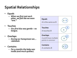


The lecture focuses on spatial relationships and topology, highlighting their importance in understanding how different spatial features interact, such as 'equals,' 'touches,' and 'overlaps.' It also discusses the concept of scale in geography, including map scale and scale of analysis, and emphasizes the significance of incorporating time into geographic processes and mapping. The information presented is part of an online geospatial education initiative at Penn State.


