1. ANALYSIS OF AN URBAN LOCAL AREA
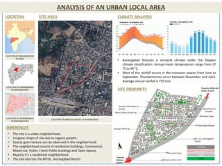
LOCATION SITE AREA
LOCATION OF MAHARASHTRA
IN INDIA
LOCATION OF AURANGABAD
IN MAHARASHTRA
LOCATION OF AURANGABAD
IN MAHARASHTRA
LOCATION OF BANSILAL NAGAR IN AURANGABAD
CLIMATE ANALYSIS
• Aurangabad features a semiarid climate under the Köppen
climate classification. Annual mean temperatures range from 17
°C to 39 °C.
• Most of the rainfall occurs in the monsoon season from June to
September. Thunderstorms occur between November and April.
Average annual rainfall is 710 mm.
SITE PROXIMITY
Railway station circle
M.T.D.C Aurangabad
Resort
Sky touch hotel
Shitla Mata Mandir
Tandoor hotel
Commercial
complex
Towards Ahilya Bai
Holkar Chowk
Towards
Railway
Station
Rajshri Shahu Garden
Kendriya Municipal
School
Rajnagar MTDC
Buildings
Open Spaces
Roads
Trees
• The site is a urban neighborhood.
• Irregular shape of site due to organic growth.
• Coarse grain texture can be observed in the neighborhood.
• The neighborhood consist of residential buildings, Commercial,
Mixed use, Public / Semi Public buildings and Open Spaces.
• Majorly it’s a residential neighborhood.
• The site also has the MTDC, Aurangabad Resort
INFERENCES
2. HIERARCHY OF OPEN SPACES
DEVELOPMENT PLAN, AURANGABAD (2001) URDPFI GUIDELINES FOR GREEN OPEN SPACE
RESIDENTIAL LAND USE
COMMERCIAL LAND USE
SEMI/PUBLIC LAND USE
OPEN SPACES
LEGENDS
EXISTING LAND-
USE PLAN
A
E
C
B
C
D
F
G
A
B
C
D
E
F
G
A) The space was then included in residential zone but is now
converted into Rajshri Shahu Garden.
B) This space again was included in residential zone but now is used as
open space.
C) This space serves as a n ground for the school but during the
evening times its open to children.
D) No provision on open space in the master plan but currently used as
open space by the locals.
E) Residential land use now serves as an open space for the
neighborhood.
F) Open space made by the locals on open plot.
G) Open space made by locals on open plot.
SITE PLAN
(Not to scale)
HIERARCHY OF GREEN OPEN SPACES ON SITE:
• In a neighborhood 3-4 local parks and playgrounds should be
provided but, in this case, there are only two small parks which
are not properly developed.
• There is no community level park and open space in the overall
site.
3. HIERARCHY OF OPEN SPACES
SITE PLAN (Not to scale)
LEGENDS
Buildings
Open Spaces
Roads
This open space is semi
developed with a small
community hall used for small
gathering.
This open space is paved
and serves the school
premises but open for
children after school.
This open space has
temple in its premises and
serves the temple activity
as well as large gatherings.
This open space has a small
temple in its premises and is
used for various activities such
as it has a net for cricket, used
for parking, used for walking,
and used by kids for playing.
MTDC lawn for the tourist and also used
by public for events and weddings.
Kendriya Municipal school
basketball court and
playground.
Rajshri Shahu Garden well
developed park with walking
track and kids play area.
4. HIERARCHY OF ROADS
LEGENDS
SUB- ARTERIAL ROAD (30 - 40M)
LOCAL STREET (10 - 20M)
MAJOR PATHWAY (3 - 10M)
HIERARCHY OF ROAD AS PER INDIAN ROAD CONGRESS
[A] SUB- ARTERIAL ROAD (30 - 40M)
[B] LOCAL STREET (10 - 20M)
[C] MAJOR PATHWAY (3 - 10M)
A
B
c