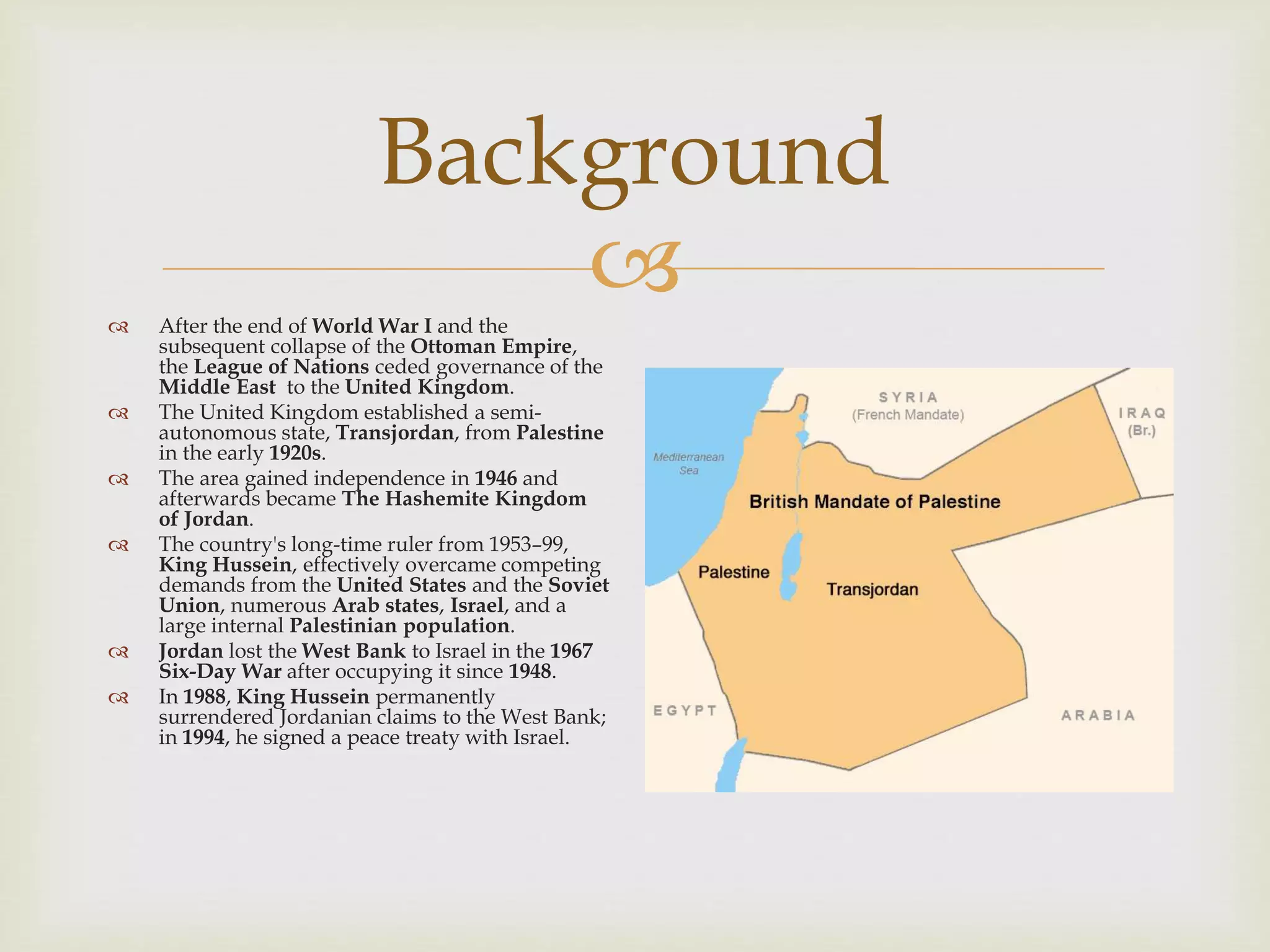
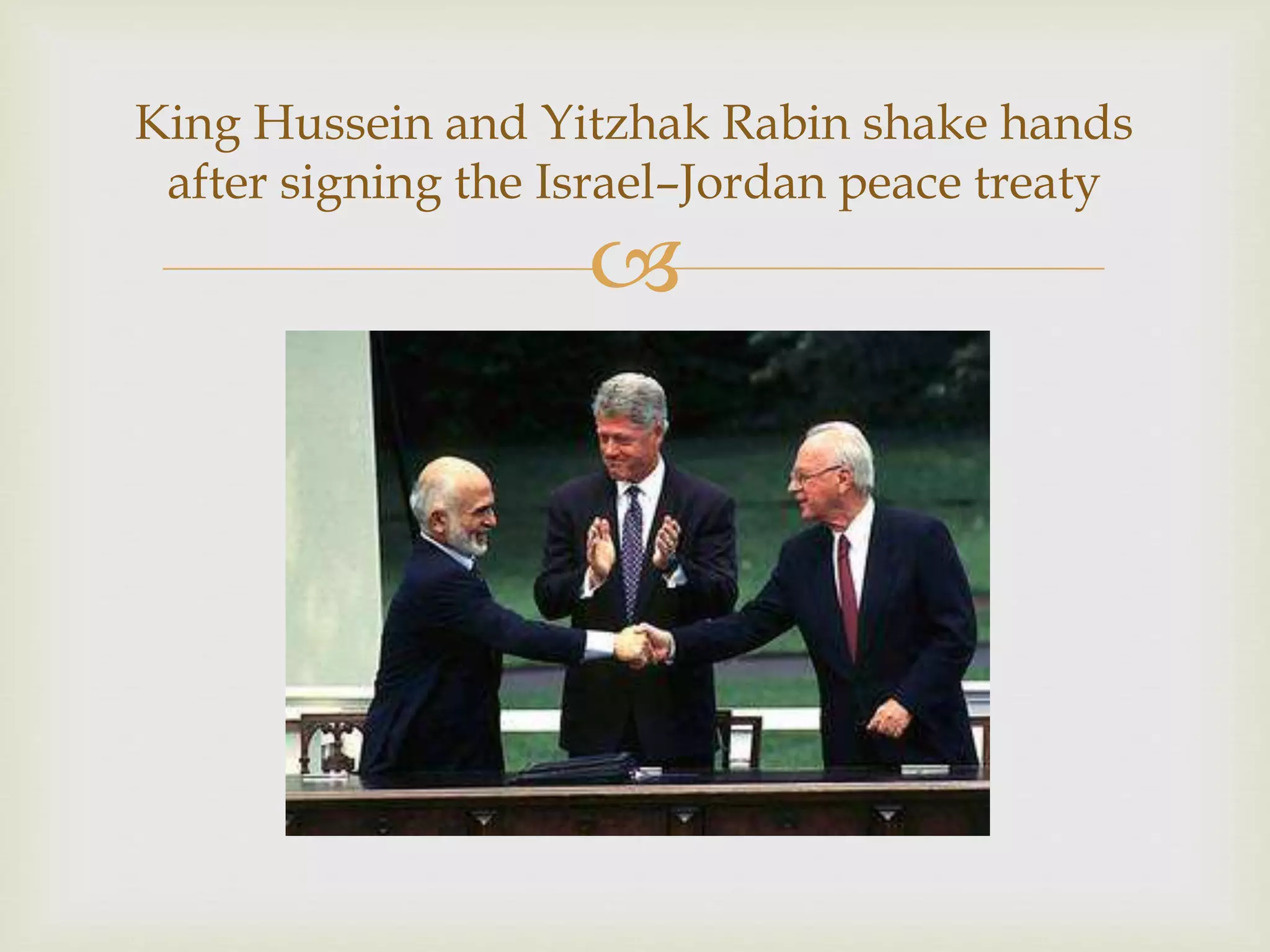

Background
 After the end of World War I and the
subsequent collapse of the Ottoman Empire,
the League of Nations ceded governance of the
Middle East to the United Kingdom.
 The United Kingdom established a semi-
autonomous state, Transjordan, from Palestine
in the early 1920s.
 The area gained independence in 1946 and
afterwards became The Hashemite Kingdom
of Jordan.
 The country's long-time ruler from 1953–99,
King Hussein, effectively overcame competing
demands from the United States and the Soviet
Union, numerous Arab states, Israel, and a
large internal Palestinian population.
 Jordan lost the West Bank to Israel in the 1967
Six-Day War after occupying it since 1948.
 In 1988, King Hussein permanently
surrendered Jordanian claims to the West Bank;
in 1994, he signed a peace treaty with Israel.

Changes to Israel’s borders after the
Six-Day War

King Hussein and Yitzhak Rabin shake hands
after signing the Israel–Jordan peace treaty

 King Abdullah II, King Hussein's oldest son, assumed the throne after his
father died in 1999.
 He has instigated modest political reforms, including the enactment of a new
electoral law in early 2016 prior to legislative elections held in September, and
significant economic liberalization and reforms to elevate growth and focus on
continuing budget insufficiencies.
 In 2016, the Islamic Action Front, which is the political arm of the Jordanian
Muslim Brotherhood, returned to parliament with fifteen seats after refusing to
participate in the preceding two elections in 2010 and 2013.
Background (cont.)

Geography
 Location: Middle East, northwest of
Saudi Arabia, between Israel (to the
west) and Iraq
 Geographic coordinates: 31 00 N, 36
00 E
 Map references: Middle East
 Area:
 Total: 89,342 sq km
 Land: 88,802 sq km
 Water: 540 sq km
 Country comparison to the world:
113
 Area – comparative: roughly three-
quarters the size of Pennsylvania;
slightly smaller than Indiana

Physical map of Jordan

 Land boundaries:
 Total: 1,744 km
 Border countries (5): Iraq 179 km, Israel 307 km, Saudi Arabia 731 km, Syria 379 km,
West Bank 148 km
 Coastline: 26 km
 Maritime claims:
 Territorial sea: 3 nm
 Climate: mainly dry desert; rainy season in west (November to April)
 Terrain: mainly desert plateau in east, plateau area in west; Great Rift Valley
separates eastern and western banks of the Jordan River
 Elevation:
 Mean elevation: 812 m
 Elevation extremes: lowest point is the Dead Sea (-431 m); highest point is the Jabal Umm
ad Dami (1,854 m)
Geography (cont.)

Geography (cont.)
Dead Sea Jabal Umm ad Dami

 Natural resources: phosphates, potash, shale oil
 Land use:
 Agricultural land: 11.4% (arable land 2%; permanent crops 1%; permanent pasture
8.4%)
 Forest: 1.1%
 Other: 87.5% (2011 est.)
 Irrigated land: 964 sq km (2012)
 Population – distribution: population mostly concentrated in the west, and
especially the northwest, in and near the capital of Amman; a substantial, but smaller
population is situated in the southwest beside the shore of the Gulf of Aqaba
 Natural hazards: droughts; periodic earthquakes; flash floods
 Environment – current issues: inadequate natural freshwater resources; decreasing
water table, salinity; deforestation; overgrazing; soil attrition; desertification;
biodiversity and ecosystem destruction/loss
Geography (cont.)

 Environment – international agreements:
 Party to: Biodiversity, Climate Change, Climate Change-Kyoto Protocol,
Desertification, Endangered Species, Hazardous Wastes, Law of the Sea, Marine
Dumping, Ozone Layer Protection, Wetlands
 Signed, but not ratified: none of the above agreements
 Geography – note: strategic location at the head of the Gulf of Aqaba and as the Arab
country that shares the longest border with Israel and the occupied West Bank
Geography (cont.)

 Population: 10,248,069 (note: increased estimate reflects reviewed postulations
about the net migration rate due to the increased flow of Syrian migrants)
 Country comparison to the world: 89
 Nationality:
 Noun: Jordanian(s)
 Adjective: Jordanian
 Ethnic groups: Jordanian 69.3%, Syrian 13.3%, Palestinian 6.7%, Egyptian 6.7%, Iraqi
1.4%, other 2.6% (includes Armenian, Circassian)
 Note: figures represent population by self-identified nationality (2015 est.)
 Languages: Arabic (official), English (commonly understood among upper and
middle classes)
 Religion: Muslim 97.2% (official; predominantly Sunni), Christian 2.2% (majority
Greek Orthodox, but some Greek and Roman Catholics, Syrian Orthodox, Coptic
Orthodox, Armenian Orthodox, and Protestant denominations), Buddhist 0.4%,
Hindu 0.1%, Jewish <0.1, folk religionist <0.1, unaffiliated <0.1, other <0.1 (2010
est.)
People and Society

 Official name: Hashemite Kingdom of Jordan ( ‫األردنية‬ ‫المملكة‬‫الهاشمية‬ , Al-Mamlakah Al-
Urdunnīyah Al-Hāshimīyah)
 Etymology: named after the Jordan River, which forms part of Jordan’s northwest
border (partially on its borders with Israel and Syria and most of its border with the
West Bank)
 Government type: Unitary parliamentary constitutional monarchy
 Monarch: Abdullah II
 Prime Minister: Omar Razzaz
 Capital: Amman
 Administrative divisions: twelve governorates (muhafazat, singular - muhafazah);
'Ajlun, Al 'Aqabah, Al Balqa', Al Karak, Al Mafraq, Al �Asimah (Amman), At
Tafilah, Az Zarqa', Irbid, Jarash, Ma'an, Madaba
 Independence: 25 May 1946 (from League of Nations mandate under British
administration)
 National holiday: Independence Day, 25 May (1946)
Government

 Constitution: previous in 1928 (before independence); post-independence constitution
adopted 28 November 1947; revised and ratified 1 January 1952
 Amendments: proposed by ten or more members of the Senate or by the House of
Representatives followed by transfer to the appropriate House committee for its
evaluation and judgement; if approved, the proposal is sent to the government for
reassertion as a draft; approval requires two-thirds majority vote of both the Senate and the
House and ratification by the king; revised several times, most recently in 2016 (2016)
 Legal system: mixed system started from codes inaugurated by the Ottoman Empire
(based on French law), British common law, and Islamic law
 International law organization participation: has not submitted an ICJ jurisdiction
declaration, but accepts ICCt jurisdiction
 Citizenship:
 Citizenship by birth: no
 Citizenship by descent only: the father has to be a citizen of Jordan
 Dual citizenship recognized: yes
 Residency requirement for naturalization: fifteen years
 Suffrage: eighteen years of age; universal
Government (cont.)

 International organization participation: ABEDA, AFESD, AMF, CAEU, CD, CICA,
EBRD, FAO, G-11, G-77, IAEA, IBRD, ICAO, ICC (national committees), ICCt, ICRM,
IDA, IDB, IFAD, IFC, IFRCS, ILO, IMF, IMO, IMSO, Interpol, IOC, IOM, IPU, ISO,
ITSO, ITU, ITUC (NGOs), LAS, MIGA, MINUSTAH, MINUSMA, MONUSCO,
NAM, OIC, OPCW, OSCE (partner), PCA, UN, UN Security Council (temporary),
UNAMID, UNCTAD, UNESCO, UNHCR, UNIDO, UNMIL, UNMISS, UNOCI,
UNRWA, UNWTO, UPU, WCO, WFTU (NGOs), WHO, WIPO, WMO, WTO
 Jordanian Ambassador to the U.S.: Dina Khalil Tawfiq Kawar (since 27 June 2016)
 U.S. Ambassador to Jordan: vacant (Henry T. Wooster is the chargé d'affaires since 24
March 2017)
Government (cont.)

 Flag description: three equal horizontal bands of black (top), representing the
Abbassid Caliphate, white, representing the Ummayyad Caliphate, and green,
representing the Fatimid Caliphate; a red isosceles triangle on the hoist side,
representing the Great Arab Revolt of 1916, and bearing a small white seven-
pointed star symbolizing the seven verses of the opening Sura (Al-Fatiha) of the
Holy Koran; the seven points on the star represent faith in One God, humanity,
national spirit, humility, social justice, virtue, and aspirations; design is based on
the Arab Revolt flag of World War I
 National symbol(s): eagle; national colors: black, white, green, red
 National anthem:
 Name: as-Salām al-Malakī al-ʾUrdunī (“The Royal Anthem of Jordan”)
 Lyrics: Abdul Monem Al-Refai
 Music: Abdul Qader al-Taneer
 Note: adopted 1946; the condensed form of the anthem is used most commonly,
whereas the full version (https://www.youtube.com/watch?v=Ws1i9_iMIxk) is set
aside for distinct events
Government (cont.)

 https://www.cia.gov/library/publications/the-world-factbook/geos/jo.html
 https://en.wikipedia.org/wiki/Jordan
 https://en.wikipedia.org/wiki/As-Salam_Al-Malaki_Al-Urduni
Sources

Jordan

  • 2.
     Background  After theend of World War I and the subsequent collapse of the Ottoman Empire, the League of Nations ceded governance of the Middle East to the United Kingdom.  The United Kingdom established a semi- autonomous state, Transjordan, from Palestine in the early 1920s.  The area gained independence in 1946 and afterwards became The Hashemite Kingdom of Jordan.  The country's long-time ruler from 1953–99, King Hussein, effectively overcame competing demands from the United States and the Soviet Union, numerous Arab states, Israel, and a large internal Palestinian population.  Jordan lost the West Bank to Israel in the 1967 Six-Day War after occupying it since 1948.  In 1988, King Hussein permanently surrendered Jordanian claims to the West Bank; in 1994, he signed a peace treaty with Israel.
  • 3.
     Changes to Israel’sborders after the Six-Day War
  • 4.
     King Hussein andYitzhak Rabin shake hands after signing the Israel–Jordan peace treaty
  • 5.
      King AbdullahII, King Hussein's oldest son, assumed the throne after his father died in 1999.  He has instigated modest political reforms, including the enactment of a new electoral law in early 2016 prior to legislative elections held in September, and significant economic liberalization and reforms to elevate growth and focus on continuing budget insufficiencies.  In 2016, the Islamic Action Front, which is the political arm of the Jordanian Muslim Brotherhood, returned to parliament with fifteen seats after refusing to participate in the preceding two elections in 2010 and 2013. Background (cont.)
  • 6.
     Geography  Location: MiddleEast, northwest of Saudi Arabia, between Israel (to the west) and Iraq  Geographic coordinates: 31 00 N, 36 00 E  Map references: Middle East  Area:  Total: 89,342 sq km  Land: 88,802 sq km  Water: 540 sq km  Country comparison to the world: 113  Area – comparative: roughly three- quarters the size of Pennsylvania; slightly smaller than Indiana
  • 7.
  • 8.
      Land boundaries: Total: 1,744 km  Border countries (5): Iraq 179 km, Israel 307 km, Saudi Arabia 731 km, Syria 379 km, West Bank 148 km  Coastline: 26 km  Maritime claims:  Territorial sea: 3 nm  Climate: mainly dry desert; rainy season in west (November to April)  Terrain: mainly desert plateau in east, plateau area in west; Great Rift Valley separates eastern and western banks of the Jordan River  Elevation:  Mean elevation: 812 m  Elevation extremes: lowest point is the Dead Sea (-431 m); highest point is the Jabal Umm ad Dami (1,854 m) Geography (cont.)
  • 9.
  • 10.
      Natural resources:phosphates, potash, shale oil  Land use:  Agricultural land: 11.4% (arable land 2%; permanent crops 1%; permanent pasture 8.4%)  Forest: 1.1%  Other: 87.5% (2011 est.)  Irrigated land: 964 sq km (2012)  Population – distribution: population mostly concentrated in the west, and especially the northwest, in and near the capital of Amman; a substantial, but smaller population is situated in the southwest beside the shore of the Gulf of Aqaba  Natural hazards: droughts; periodic earthquakes; flash floods  Environment – current issues: inadequate natural freshwater resources; decreasing water table, salinity; deforestation; overgrazing; soil attrition; desertification; biodiversity and ecosystem destruction/loss Geography (cont.)
  • 11.
      Environment –international agreements:  Party to: Biodiversity, Climate Change, Climate Change-Kyoto Protocol, Desertification, Endangered Species, Hazardous Wastes, Law of the Sea, Marine Dumping, Ozone Layer Protection, Wetlands  Signed, but not ratified: none of the above agreements  Geography – note: strategic location at the head of the Gulf of Aqaba and as the Arab country that shares the longest border with Israel and the occupied West Bank Geography (cont.)
  • 12.
      Population: 10,248,069(note: increased estimate reflects reviewed postulations about the net migration rate due to the increased flow of Syrian migrants)  Country comparison to the world: 89  Nationality:  Noun: Jordanian(s)  Adjective: Jordanian  Ethnic groups: Jordanian 69.3%, Syrian 13.3%, Palestinian 6.7%, Egyptian 6.7%, Iraqi 1.4%, other 2.6% (includes Armenian, Circassian)  Note: figures represent population by self-identified nationality (2015 est.)  Languages: Arabic (official), English (commonly understood among upper and middle classes)  Religion: Muslim 97.2% (official; predominantly Sunni), Christian 2.2% (majority Greek Orthodox, but some Greek and Roman Catholics, Syrian Orthodox, Coptic Orthodox, Armenian Orthodox, and Protestant denominations), Buddhist 0.4%, Hindu 0.1%, Jewish <0.1, folk religionist <0.1, unaffiliated <0.1, other <0.1 (2010 est.) People and Society
  • 13.
      Official name:Hashemite Kingdom of Jordan ( ‫األردنية‬ ‫المملكة‬‫الهاشمية‬ , Al-Mamlakah Al- Urdunnīyah Al-Hāshimīyah)  Etymology: named after the Jordan River, which forms part of Jordan’s northwest border (partially on its borders with Israel and Syria and most of its border with the West Bank)  Government type: Unitary parliamentary constitutional monarchy  Monarch: Abdullah II  Prime Minister: Omar Razzaz  Capital: Amman  Administrative divisions: twelve governorates (muhafazat, singular - muhafazah); 'Ajlun, Al 'Aqabah, Al Balqa', Al Karak, Al Mafraq, Al �Asimah (Amman), At Tafilah, Az Zarqa', Irbid, Jarash, Ma'an, Madaba  Independence: 25 May 1946 (from League of Nations mandate under British administration)  National holiday: Independence Day, 25 May (1946) Government
  • 14.
      Constitution: previousin 1928 (before independence); post-independence constitution adopted 28 November 1947; revised and ratified 1 January 1952  Amendments: proposed by ten or more members of the Senate or by the House of Representatives followed by transfer to the appropriate House committee for its evaluation and judgement; if approved, the proposal is sent to the government for reassertion as a draft; approval requires two-thirds majority vote of both the Senate and the House and ratification by the king; revised several times, most recently in 2016 (2016)  Legal system: mixed system started from codes inaugurated by the Ottoman Empire (based on French law), British common law, and Islamic law  International law organization participation: has not submitted an ICJ jurisdiction declaration, but accepts ICCt jurisdiction  Citizenship:  Citizenship by birth: no  Citizenship by descent only: the father has to be a citizen of Jordan  Dual citizenship recognized: yes  Residency requirement for naturalization: fifteen years  Suffrage: eighteen years of age; universal Government (cont.)
  • 15.
      International organizationparticipation: ABEDA, AFESD, AMF, CAEU, CD, CICA, EBRD, FAO, G-11, G-77, IAEA, IBRD, ICAO, ICC (national committees), ICCt, ICRM, IDA, IDB, IFAD, IFC, IFRCS, ILO, IMF, IMO, IMSO, Interpol, IOC, IOM, IPU, ISO, ITSO, ITU, ITUC (NGOs), LAS, MIGA, MINUSTAH, MINUSMA, MONUSCO, NAM, OIC, OPCW, OSCE (partner), PCA, UN, UN Security Council (temporary), UNAMID, UNCTAD, UNESCO, UNHCR, UNIDO, UNMIL, UNMISS, UNOCI, UNRWA, UNWTO, UPU, WCO, WFTU (NGOs), WHO, WIPO, WMO, WTO  Jordanian Ambassador to the U.S.: Dina Khalil Tawfiq Kawar (since 27 June 2016)  U.S. Ambassador to Jordan: vacant (Henry T. Wooster is the chargé d'affaires since 24 March 2017) Government (cont.)
  • 16.
      Flag description:three equal horizontal bands of black (top), representing the Abbassid Caliphate, white, representing the Ummayyad Caliphate, and green, representing the Fatimid Caliphate; a red isosceles triangle on the hoist side, representing the Great Arab Revolt of 1916, and bearing a small white seven- pointed star symbolizing the seven verses of the opening Sura (Al-Fatiha) of the Holy Koran; the seven points on the star represent faith in One God, humanity, national spirit, humility, social justice, virtue, and aspirations; design is based on the Arab Revolt flag of World War I  National symbol(s): eagle; national colors: black, white, green, red  National anthem:  Name: as-Salām al-Malakī al-ʾUrdunī (“The Royal Anthem of Jordan”)  Lyrics: Abdul Monem Al-Refai  Music: Abdul Qader al-Taneer  Note: adopted 1946; the condensed form of the anthem is used most commonly, whereas the full version (https://www.youtube.com/watch?v=Ws1i9_iMIxk) is set aside for distinct events Government (cont.)
  • 17.