Iraq
•Download as PPTX, PDF•
8 likes•5,698 views

The document provides a country profile of Iraq, detailing its official name, capital, languages, government, exports, and other key facts. It discusses Iraq's geography, climate, transportation infrastructure including roads, railways, ports and airports. The profile also covers Iraq's major religions, tourist attractions, and the languages spoken in the country.

Recommended
More Related Content
What's hot
What's hot (20)
Similar to Iraq
Similar to Iraq (16)
More from Roopesh VN
Recently uploaded
Recently uploaded (20)
Iraq
- 3. COUNTRY PROFILE Official Name : Al-Jumhūriyyah al-ʿIrāqiyyah (Republic of Iraq) Capital : Baghdad Official Language : Arabic & Kurdish Demonym : Iraqi Government : Federal Parliamentary Republic President : Fuad Masum Prime Minister : Haider al-Ababi Area : 4,37,072 km2 (59th) Population : 36,004,552 (36th) Currency : Iraqi Dinar (IQD) Major Religion : Islam Main exports : Crude oil International Dialing code : 964
- 4. LOCATION
- 6. GEOGRAPHY The geography of Iraq is diverse and falls into four main regions • the desert (west of the Euphrates) • Upper Mesopotamia (between the upper Tigris and Euphrates rivers) • the northern highlands of Iraqi Kurdistan • Lower Mesopotamia, the alluvial plain extending from around Tikrit to the Persian Gulf. Iraq, a triangle of mountains, desert, and fertile river valley, is bounded on the east by Iran on the north by Turkey on the west by Syria and Jordan on the south by Saudi Arabia and Kuwait The country has arid desert land west of the Euphrates, a broad central valley between the Euphrates and the Tigris, and mountains in the northeast.
- 8. CLIMATE Iraq’s average temperature is 70 °F (21°C) Average monthly rainfall is less than an inch (16 mm), depending on the season Two seasons Summer : May to October Winter : December to February Temperatures in Baghdad average 95 °F (35 °C), but have been recorded up to 123 °F (51 °C) during summers Temperatures are mild with bouts of hot and cold ranging between 35 and 60 °F (2 to 15 °C) during winters Rainfall averages just over an inch per month (29 mm) between November and April.
- 9. MOUNTAINS
- 10. Two major rivers, Tigris and Euphrates run south through the center of Iraq and flow into the Shatt al-Arab near the Persian Gulf. These rivers provide Iraq with significant amounts of fertile land. RIVERS
- 11. TRANSPORTATION Transport in Iraq consists of highways, railways, waterways, pipelines, ports and harbors, marines and airports. Roads Total: 44,900 km Paved: 37,851 km Unpaved: 7,049 km Road traffic crashes rank as one of the leading causes of mortality in Iraq. Around 75,000 lives were lost during the period 1979 to 2011 due to road traffic crashes. Highway Of Death
- 12. RAILWAY Iraqi Republic Railways (IRR) is the state company of Iraqi Railway which is an economical establishment and symbol that contributed in the economical, civilization and social development of Iraq. IRR is composed of 1905 route-km. The railway suffered approximately U.S.$1 billion in war and looting damage from 1980 to 2003
- 13. METRO Baghdad adopted the modernization by constructing a project named ‘Metro Baghdad’ in order to dismantle the traffic congestion in the main capital. The metro consist of two lines and one main hub. First : 18km (20 stations) Second : 21km (21 stations)
- 14. PORTS Umm Qasr Port Port of Basra Abu Flous Port
- 15. AIRPORTS Iraq has about 104 airports as of 2012. Major airports include: Baghdad International Airport Basra International Airport Mosul International Airport Erbil International Airport Sulaimaniyah International Airport Najaf International Airport
- 16. AIRWAYSS
- 17. LANGUAGE According to the constitution of 2005, the two official languages of Iraq are Arabic and Kurdish Turkmen and Assyrian neoAramaic also are official languages in regions where they are spoken. The two main regional dialects of Arabic spoken in Iraq are Mesopotamian (spoken by about 11.5 million) North Mesopotamian (spoken by about 5.4 million) Other languages in Iraq are Armenian, Azeri, and Chaldean Neo-Aramaic.
- 18. RELIGION 97 percent of Iraq’s population is Muslim. 60 – 65% - Shia Community 30 – 37% - Sunni Community
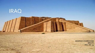
- 21. Ziggurat ofUr
- 24. Baghdad Zoo
- 25. CONTRIBUTION