Download to read offline
![International Research Journal of Engineering and Technology (IRJET) e-ISSN: 2395-0056
Volume: 06 Issue: 06 | June 2019 www.irjet.net p-ISSN: 2395-0072
© 2019, IRJET | Impact Factor value: 7.211 | ISO 9001:2008 Certified Journal | Page 488
Drone Delivery System
Pankaj S Kambire1, Akash S Auti 2, Ajinkya A Barge3, Guided By: Dr. P.R Badadapure
1,2,3Students, Department of ENTC Engineering, JSPM, ICOER, Pune, India.
---------------------------------------------------------------------***---------------------------------------------------------------------
Abstract - The internet evolution continues. Whether it is
online shopping, ordering food, buying gifts, grocery runs or
personal packages the consumer space in increasingly relying
on fast and reliable door step delivery. The market for
delivering goods is massive, Shopping, logisticonlineshopping
businesses are investing heavily in the entire supply chain up
to the last mile delivery to make it fast and efficient. On the
other hand, there are significant technological advance in
building drone in the delivery area. Drone could allow
accelerated delivery time, improved accuracy and reduce
human cost associated with delivery.this system is designed
using the naza m-lite flight controller, ESC, GPS module .
Key Words: Naza M-lite Flight controller, ESC, GPS
Module.
1. INTRODUCTION
The technological evolution that characterised the last
century deeply modified the manner folks perform daily
activities. This is evident once considering, for example,
the novel transformations brought within the
organization of house works by refrigerators/freezers,
laundry machines, etc. In the last years, humanity is
witnessing a replacement evolution, in which appliances
and devices that once required a human command in
order to be activated have become more and a lot of
intelligent and ready to take choices supported the
external context. Beginner drones typically don't have
GPS, however a lot of advanced drones create use of GPS
receivers among the navigation and management loop
that permits for a few good GPS drone navigation
features that include: Position Hold: permits the drone to
keep up position at a hard and fast altitude and
placement. Return to Home: The drone remembers the
spot from wherever it took removed from, and at the
press of the come back to home button, it will
automatically return to this spot.
2. LITERATURE SURVEY
1st Joseph Christopher Fancher Et. Al (2017) In
Drones for Medical Supply StatesDroneapplicationsinthe
United States have the potential to shape the future of the
economy, society and the daily lives of people. In today’s
society, there are many negative connotations that are
associated with drones. When people think of drones they
usually associate them with video surveillance or military
warfare purposes. Drones are currently being used in the
U.S. for surveying, inspecting, and imaging.Strictregulations
and licensing requirements are enforced by U.S. federal
agencies, which currently hinder the exploration of drone
technologies. However, the use of drones for commercial
application has been an increasing topic of exploration for
many companies. The top three companies that are
exploring the use of commercial drone applications are
Amazon Prime Air, DHL and Google [1]. Google has been
exploring commercial drone and disaster reliefapplications.
Recently, Google released information about a new project
they have been developing, “Project Wing.” Project Winghas
been a work in progress for two years with a goal of
completion coming in 2017. The goal of Google’s Project
Wing is to provide disaster relief by delivering aid, including
water and medical supplies to affected areas. To avoid any
legal conflicts Google has consulted the Federal Aviation
Administration (FAA) and has been conducting their flight
and performance tests in Queensland, Australia.Regulations
were established after consulting the FAA, which include a
maximum drone altitude of 500 feet and air traffic control
system structured byexistingcell network infrastructure [2].
Plant protection for agriculture and forestry jobs. The
unmanned aircraft by the flight platform (fixed-wing, single
rotor, multi-rotor) composition, GPS flight control, spray
bodies of three parts, by remote control or GPS groundflight
control to achieve spraying operation, the agent can be
sprayed, seeds, powders, etc. China's sales of plant
protection drones consist of two types, oil dropping plant
protection agents and plant protection spraying drones. [3]
2nd HimadriNath Saha et.al (2018) in A low cost
fully autonomousGPS(GlobalPositioningSystem)based
Quad copter for disastermanagement AuthorStatesQuad
copter is one of the examples of a man machine concept
implementation. In real time whena Disasterhappensdue to
earthquake, any construction collapsed or in time of flood,
manpower of disaster management team reaches there and
rescues the victims; But sometimes too many areas where
victims are there and they are alive but people from rescue
team are not able to reach there. In this situation quad
copter can help; like if Quad copter is flying at disaster area
then through night vision it is possible to see how many
people are stuck and where they stuck on and how many of
them are alive. If anywhere suddenly conflagrationhappens,
and then Quad copter can spray water or any fire resistant.
As it has camera with live broadcasting system, it can easily
show everything live and any rescue team of any disaster
management team can take proper action. In time of flood,
where rescue team is not able to reach, there Quad copter
can go and can provide drinking water and proper food, so
that they can survive.](https://image.slidesharecdn.com/irjet-v6i697-191109105244/85/IRJET-Drone-Delivery-System-1-320.jpg)
![International Research Journal of Engineering and Technology (IRJET) e-ISSN: 2395-0056
Volume: 06 Issue: 06 | June 2019 www.irjet.net p-ISSN: 2395-0072
© 2019, IRJET | Impact Factor value: 7.211 | ISO 9001:2008 Certified Journal | Page 488
Drone Delivery System
Pankaj S Kambire1, Akash S Auti 2, Ajinkya A Barge3, Guided By: Dr. P.R Badadapure
1,2,3Students, Department of ENTC Engineering, JSPM, ICOER, Pune, India.
---------------------------------------------------------------------***---------------------------------------------------------------------
Abstract - The internet evolution continues. Whether it is
online shopping, ordering food, buying gifts, grocery runs or
personal packages the consumer space in increasingly relying
on fast and reliable door step delivery. The market for
delivering goods is massive, Shopping, logisticonlineshopping
businesses are investing heavily in the entire supply chain up
to the last mile delivery to make it fast and efficient. On the
other hand, there are significant technological advance in
building drone in the delivery area. Drone could allow
accelerated delivery time, improved accuracy and reduce
human cost associated with delivery.this system is designed
using the naza m-lite flight controller, ESC, GPS module .
Key Words: Naza M-lite Flight controller, ESC, GPS
Module.
1. INTRODUCTION
The technological evolution that characterised the last
century deeply modified the manner folks perform daily
activities. This is evident once considering, for example,
the novel transformations brought within the
organization of house works by refrigerators/freezers,
laundry machines, etc. In the last years, humanity is
witnessing a replacement evolution, in which appliances
and devices that once required a human command in
order to be activated have become more and a lot of
intelligent and ready to take choices supported the
external context. Beginner drones typically don't have
GPS, however a lot of advanced drones create use of GPS
receivers among the navigation and management loop
that permits for a few good GPS drone navigation
features that include: Position Hold: permits the drone to
keep up position at a hard and fast altitude and
placement. Return to Home: The drone remembers the
spot from wherever it took removed from, and at the
press of the come back to home button, it will
automatically return to this spot.
2. LITERATURE SURVEY
1st Joseph Christopher Fancher Et. Al (2017) In
Drones for Medical Supply StatesDroneapplicationsinthe
United States have the potential to shape the future of the
economy, society and the daily lives of people. In today’s
society, there are many negative connotations that are
associated with drones. When people think of drones they
usually associate them with video surveillance or military
warfare purposes. Drones are currently being used in the
U.S. for surveying, inspecting, and imaging.Strictregulations
and licensing requirements are enforced by U.S. federal
agencies, which currently hinder the exploration of drone
technologies. However, the use of drones for commercial
application has been an increasing topic of exploration for
many companies. The top three companies that are
exploring the use of commercial drone applications are
Amazon Prime Air, DHL and Google [1]. Google has been
exploring commercial drone and disaster reliefapplications.
Recently, Google released information about a new project
they have been developing, “Project Wing.” Project Winghas
been a work in progress for two years with a goal of
completion coming in 2017. The goal of Google’s Project
Wing is to provide disaster relief by delivering aid, including
water and medical supplies to affected areas. To avoid any
legal conflicts Google has consulted the Federal Aviation
Administration (FAA) and has been conducting their flight
and performance tests in Queensland, Australia.Regulations
were established after consulting the FAA, which include a
maximum drone altitude of 500 feet and air traffic control
system structured byexistingcell network infrastructure [2].
Plant protection for agriculture and forestry jobs. The
unmanned aircraft by the flight platform (fixed-wing, single
rotor, multi-rotor) composition, GPS flight control, spray
bodies of three parts, by remote control or GPS groundflight
control to achieve spraying operation, the agent can be
sprayed, seeds, powders, etc. China's sales of plant
protection drones consist of two types, oil dropping plant
protection agents and plant protection spraying drones. [3]
2nd HimadriNath Saha et.al (2018) in A low cost
fully autonomousGPS(GlobalPositioningSystem)based
Quad copter for disastermanagement AuthorStatesQuad
copter is one of the examples of a man machine concept
implementation. In real time whena Disasterhappensdue to
earthquake, any construction collapsed or in time of flood,
manpower of disaster management team reaches there and
rescues the victims; But sometimes too many areas where
victims are there and they are alive but people from rescue
team are not able to reach there. In this situation quad
copter can help; like if Quad copter is flying at disaster area
then through night vision it is possible to see how many
people are stuck and where they stuck on and how many of
them are alive. If anywhere suddenly conflagrationhappens,
and then Quad copter can spray water or any fire resistant.
As it has camera with live broadcasting system, it can easily
show everything live and any rescue team of any disaster
management team can take proper action. In time of flood,
where rescue team is not able to reach, there Quad copter
can go and can provide drinking water and proper food, so
that they can survive.](https://image.slidesharecdn.com/irjet-v6i697-191109105244/75/IRJET-Drone-Delivery-System-1-2048.jpg)
![International Research Journal of Engineering and Technology (IRJET) e-ISSN: 2395-0056
Volume: 06 Issue: 06 | June 2019 www.irjet.net p-ISSN: 2395-0072
© 2019, IRJET | Impact Factor value: 7.211 | ISO 9001:2008 Certified Journal | Page 489
UAV’s have the added advantage of not having the
operator on board which makes them more expendable and
allows them to operate in extreme and dangerous
environments with no risk to the operator. UAVs are agile,
fast, can exhibit autonomous behaviour and hence perform
operations hard to execute by human operators, and at low
operating costs but the current use of drones in Disaster
Response scenarios is extremely limited due to the limited
range, prohibitive cost of sensors required for safeflightand
the requirement for skilled operators to fly the drones. In a
typical scenario, UAVs will be deployed inanarea ofinterest,
perform sensory operations to collect evidence of the
presence of a victim, and report their collected information
to a remote ground station orrescueteam.Thekeychallenge
in making drones ubiquitous in disaster response is to
localize the robot purely through its on-board sensors
enabling it to perform true autonomous flight but equipping
each and every drone with the required sensors for
autonomous navigation drives up the per unit price of the
drones and drives up the cost of the entire system. In order
to overcome this issue, we propose a networked system
where different classes of drones are used for different
purposes and the data collected from the onboard sensorsis
transferred to the cloud for use by other drones in the
network. The mapping and 3D modelling of theaffectedarea
will be performed by a class of Path finder drones that carry
laser range scanners, inertial measurement units(IMU) and
stereo cameras for accurate modelling of the terrain. The 3D
map created by the path finder drones will be transferred to
the cloud where it can be used by Drones equipped with
Infrared scanners to detect people who are stranded, these
drones on locating human beings log the GPS coordinates
which are then passed on to heavy lift cargo drones which
make use of the logged coordinates to performaerial drop of
supplies. The maps created will be of a higher quality than
satellite imagery as they can provide depth information as
well as provide fast refreshes to the map which cannot be
done through satellite imagery. In theaftermathofa disaster
quick response of rescue teams can make a huge difference
in the number of survivors and these maps can help SAR
teams choose the best path to reach stranded people in
shortest time.
3rd Apurv Saha et.al (2017) in FPV Drone with
GPS used for Surveillance in Remote Areas author states
Drones are the hottest consumer product of 2016. Last year,
a true revolution occurred in terms of the hardware and
software used in both the manufacturing process and in
controlling drones. This has made these devices easier to
maneuverer, able to fly more, be safer and able to obtain
video footage and high-resolution photos at a professional
level. In recent research [4] it is clearly observedthatdrones
are about to create a revolution in human life and industry.
The most important aspect is that it can be used for effective
surveillance at places where human being can’t reach. To
reduce the cost of the drones, Low cost avionics System
Prototypes [5] are made. It makes the structure light as well
as strong. In comparison to these prototypes we have tried
to improve the video transmission of data from drone to the
server by increasing the quality as well as making it fast.
Researchers have also tried to receive the data at multiple
devices and for analysis they have stored the data in their
server. Surveillance Drone for Landmine Detection [6]
provides the exact location of mine and sends it through
GSM. Paper described above uses a Multivii flight controller
connected to Arduino with GPS and thermal camera in
contrast to these prototypes. We have tried to make the
connection more reliable by using a channel of 5.8 GHz and
increasing the speed of our prototype. 978-1-5386-1931-
5/17/$31.00 ©2017 IEEE Thermal camera is also one of the
important devices used these days with regard to
surveillance. Digital Image Stabilization [7] technique is
introduced by implementation of the Speed-Up Robust
Feature (SURF) method. The fundamental concept is to
compare the current image with another from the previous
frame. The result indicates that SURF method is useful in
stabilizing the image capturing process in drone. In the
coming days, Image Processing can be utilizedtoprocessthe
captured images.
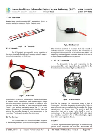
3. BLOCK DIGRAM
Fig 3.1 Block Digram
3.1 Naza M-lite flight controller
Naza m-lite flight controller is use to the set the different
types of modes which drone have to flight.
It comes with the three modes Atti mode ,fail-safe,GPSMode
.it has the voltage protection indicator.
Fig 3.2 naza m-lite flight controller](https://image.slidesharecdn.com/irjet-v6i697-191109105244/85/IRJET-Drone-Delivery-System-2-320.jpg)
![International Research Journal of Engineering and Technology (IRJET) e-ISSN: 2395-0056
Volume: 06 Issue: 06 | June 2019 www.irjet.net p-ISSN: 2395-0072
© 2019, IRJET | Impact Factor value: 7.211 | ISO 9001:2008 Certified Journal | Page 491
drone . 1st mode is atti mode in this mode the drone will hold
the altitude. 2nd mode is RTH (GPS) in this mode the drone
will hold the GPS Position and also the follow the mission
planner mission set .3rd mode is the failsafe mode when the
drone will go out of range the controller will safely land the
drone in land.
Fig 4.1 result
5. CONCLUSION
This project describes a drone whose operation is
completely based on Naza M-Lite flight controller. Project
provides accurate delivery with the help of GPS using drone.
This project reduces time of delivery and gives precise
performance. With the help of ESC we can control the
behaviour of drone and hence provide better operation to
fulfil the requirements. Using transmitter we can adjust the
direction and speed of drone. In addition with camera we
can detect the suspicious activity in the unmanned area.
REFERENCES
[1] Rao, Bharat, Ashwin Goutham Gopi, andRomana Maione.
"The Societal Impact of Commercial Drones". Technology in
Society 45 (2016): 83-90. Web. 3 Aug. 2016.
[2] Google's 'Project Wing' commercial drone service to
launch in 2017, AOL Inc, New York, 2015.
[3] Francisco, Newley. "Chinese Drone Maker Plows Into
Agriculture". WSJ. N.p., 2015. Web. 17 Aug. 2016.
[4] Z. Zaheer, A. Usmani, E. Khan and M. A. Qadeer, "Aerial
surveillance system using UAV," 2016 Thirteenth
International Conference on Wireless and Optical
CommunicationsNetworks(WOCN),Hyderabad,2016,Pp.1-
7. doi: 10.1109/WOCN.2016.7759885
[5] E. Wang, S. Zhang and Z. Zhang, "Research on Composite
Material UAV Low-Cost Avionics System Prototype," 2012
8th International Conference on Wireless Communications,
Networking and Mobile Computing, Shanghai, 2012, pp.1-4.
doi: 10.1109/WiCOM.2012.6478650
[6] Y. Ganesh, R. Raju and R. Hegde, "Surveillance Drone for
Landmine Detection," 2015 International Conference on
Advanced Computing and Communications (ADCOM),
Chennai, 2015, pp. 33-38. doi: 10.1109/ADCOM.2015.13
[7] E. Mingkhwan and W. Khawsuk, "Digital image
stabilization technique forfixedcamera onsmall sizedrone,"
2017 Third Asian Conference on Defence Technology
(ACDT), Phuket, 2017, pp. 12-19.](https://image.slidesharecdn.com/irjet-v6i697-191109105244/85/IRJET-Drone-Delivery-System-4-320.jpg)

This document summarizes a research paper on drone delivery systems. It discusses how online shopping and delivery is increasingly relying on fast doorstep delivery. Drone delivery could allow for accelerated delivery times, improved accuracy, and reduced human costs compared to traditional delivery methods. The system is designed using a Naza M-lite flight controller, ESC (electronic speed controller), and GPS module. It then reviews related work on using drones for medical supply delivery in disaster relief situations and for agricultural purposes like plant protection.


![HMC_Industry_Report_Drone_Technology_160321[1]](https://cdn.slidesharecdn.com/ss_thumbnails/d2be7b1b-4131-4f7e-89f2-ef0bdcf6aa58-170130024403-thumbnail.jpg?width=640&height=640&fit=bounds)
![HMC industry report_drone_technology_160321[1]](https://cdn.slidesharecdn.com/ss_thumbnails/hmcindustryreportdronetechnology1603211-170130024210-thumbnail.jpg?width=640&height=640&fit=bounds)
![Hmc industry report_drone_technology_160321[1]](https://cdn.slidesharecdn.com/ss_thumbnails/hmcindustryreportdronetechnology1603211-170130024004-thumbnail.jpg?width=640&height=640&fit=bounds)


