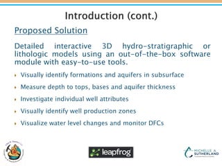
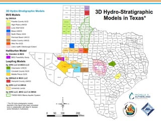
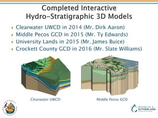
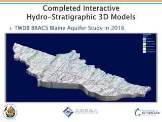
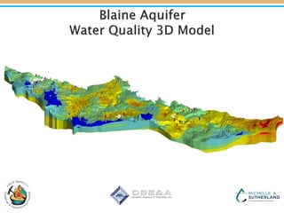
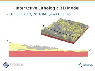
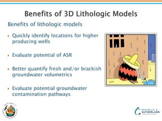
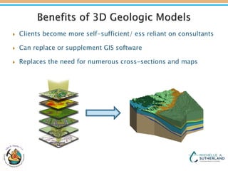
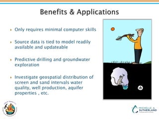
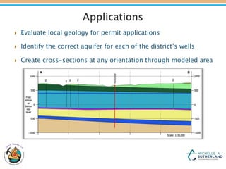
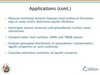
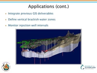
TAGD Regular Business Meeting
Austin Crowne Plaza
January 26th, 2017
Michelle A. Sutherland, LLC, PE
Allan R. Standen, LLC, PG
Consulting Philosophy
 A client should receive project deliverables that allow
them to make decisions with the provided data, reducing
their need for additional consulting services.
 The client should receive or have easy access to all source
data used to make interpretations for the project.
 Deliverables should be dynamic, allowing future research
to be easily integrated with the existing research.
Problem
Groundwater district staff need easy access to
groundwater data to make daily, permit and long-term
aquifer management decisions and communicate
those decisions to stakeholders.
Proposed Solution
Detailed interactive 3D hydro-stratigraphic or
lithologic models using an out-of-the-box software
module with easy-to-use tools.
 Visually identify formations and aquifers in subsurface
 Measure depth to tops, bases and aquifer thickness
 Investigate individual well attributes
 Visually identify well production zones
 Visualize water level changes and monitor DFCs
 Clearwater UWCD in 2014 (Mr. Dirk Aaron)
 Middle Pecos GCD in 2015 (Mr. Ty Edwards)
 University Lands in 2015 (Mr. James Buice)
 Crockett County GCD in 2016 (Mr. Slate Williams)
Clearwater UWCD Middle Pecos GCD
 TWDB BRACS Blaine Aquifer Study in 2016
 Hemphill GCD, 2016 (Ms. Janet Guthrie)
A
A’
A
A’
Benefits of lithologic models
 Quickly identify locations for higher
producing wells
 Evaluate potential of ASR
 Better quantify fresh and/or brackish
groundwater volumetrics
 Evaluate potential groundwater
contamination pathways
 Clients become more self-sufficient/ ess reliant on consultants
 Can replace or supplement GIS software
 Replaces the need for numerous cross-sections and maps
 Only requires minimal computer skills
 Source data is tied to model readily
available and updateable
 Predictive drilling and groundwater
exploration
 Investigate geospatial distribution of
screen and sand intervals water
quality, well production, aquifer
properties , etc.
 Evaluate local geology for permit applications
 Identify the correct aquifer for each of the district’s wells
 Create cross-sections at any orientation through modeled area
 Measure estimated distance between land surface to formation
tops or water levels, determine aquifer thickness
 Investigate alluvial resources and groundwater/surface water
interactions
 Compare water level surfaces, GAMs and TWDB reports
 Evaluate geospatial distribution of groundwater contamination,
aquifer properties or sand continuity
 Calculate volumetric estimates of aquifer resources
 Integrate previous GIS deliverables
 Define vertical brackish water zones
 Monitor injection well intervals
A 3D hydro-stratigraphic model provides a District with:
 A better understanding of aquifer’s geo-spatial complexity
 An evolving tool and framework for all future projects
 A platform to visualize all data types
 A powerful proactive tool for future litigation
 Gives the staff the power to make informed decisions quickly
Michelle Sutherland
michelleasutherland@gmail.com
949-702-3622
and
Allan Standen
astanden@att.net
512-731-6242

Interactive 3D Geological Models for Daily Operations, Permitting, and Stakeholder Communication

  • 1.
    TAGD Regular BusinessMeeting Austin Crowne Plaza January 26th, 2017 Michelle A. Sutherland, LLC, PE Allan R. Standen, LLC, PG
  • 2.
    Consulting Philosophy  Aclient should receive project deliverables that allow them to make decisions with the provided data, reducing their need for additional consulting services.  The client should receive or have easy access to all source data used to make interpretations for the project.  Deliverables should be dynamic, allowing future research to be easily integrated with the existing research.
  • 3.
    Problem Groundwater district staffneed easy access to groundwater data to make daily, permit and long-term aquifer management decisions and communicate those decisions to stakeholders.
  • 4.
    Proposed Solution Detailed interactive3D hydro-stratigraphic or lithologic models using an out-of-the-box software module with easy-to-use tools.  Visually identify formations and aquifers in subsurface  Measure depth to tops, bases and aquifer thickness  Investigate individual well attributes  Visually identify well production zones  Visualize water level changes and monitor DFCs
  • 6.
     Clearwater UWCDin 2014 (Mr. Dirk Aaron)  Middle Pecos GCD in 2015 (Mr. Ty Edwards)  University Lands in 2015 (Mr. James Buice)  Crockett County GCD in 2016 (Mr. Slate Williams) Clearwater UWCD Middle Pecos GCD
  • 7.
     TWDB BRACSBlaine Aquifer Study in 2016
  • 9.
     Hemphill GCD,2016 (Ms. Janet Guthrie) A A’ A A’
  • 10.
    Benefits of lithologicmodels  Quickly identify locations for higher producing wells  Evaluate potential of ASR  Better quantify fresh and/or brackish groundwater volumetrics  Evaluate potential groundwater contamination pathways
  • 11.
     Clients becomemore self-sufficient/ ess reliant on consultants  Can replace or supplement GIS software  Replaces the need for numerous cross-sections and maps
  • 12.
     Only requiresminimal computer skills  Source data is tied to model readily available and updateable  Predictive drilling and groundwater exploration  Investigate geospatial distribution of screen and sand intervals water quality, well production, aquifer properties , etc.
  • 13.
     Evaluate localgeology for permit applications  Identify the correct aquifer for each of the district’s wells  Create cross-sections at any orientation through modeled area
  • 14.
     Measure estimateddistance between land surface to formation tops or water levels, determine aquifer thickness  Investigate alluvial resources and groundwater/surface water interactions  Compare water level surfaces, GAMs and TWDB reports  Evaluate geospatial distribution of groundwater contamination, aquifer properties or sand continuity  Calculate volumetric estimates of aquifer resources
  • 15.
     Integrate previousGIS deliverables  Define vertical brackish water zones  Monitor injection well intervals
  • 16.
    A 3D hydro-stratigraphicmodel provides a District with:  A better understanding of aquifer’s geo-spatial complexity  An evolving tool and framework for all future projects  A platform to visualize all data types  A powerful proactive tool for future litigation  Gives the staff the power to make informed decisions quickly
  • 17.