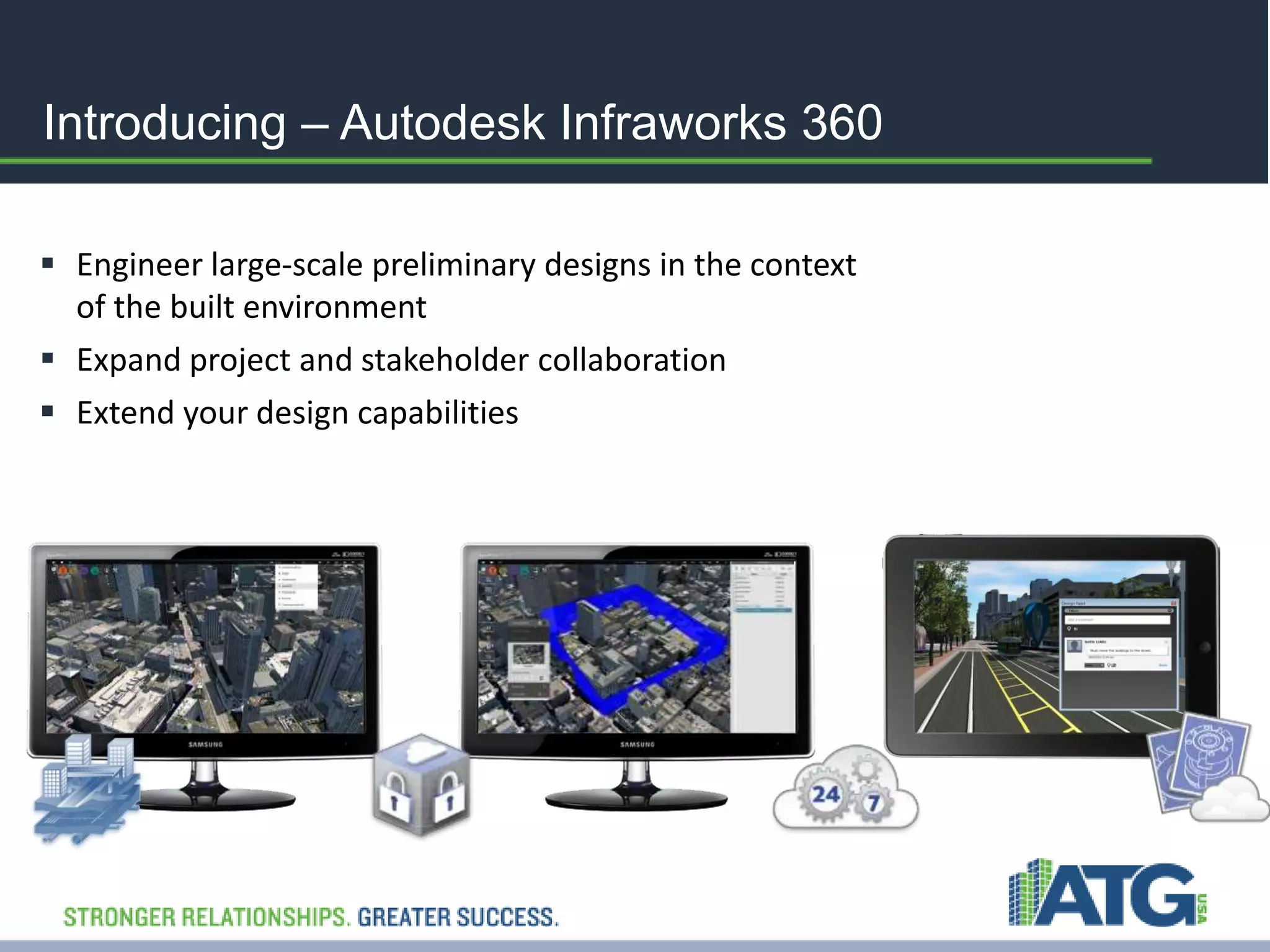
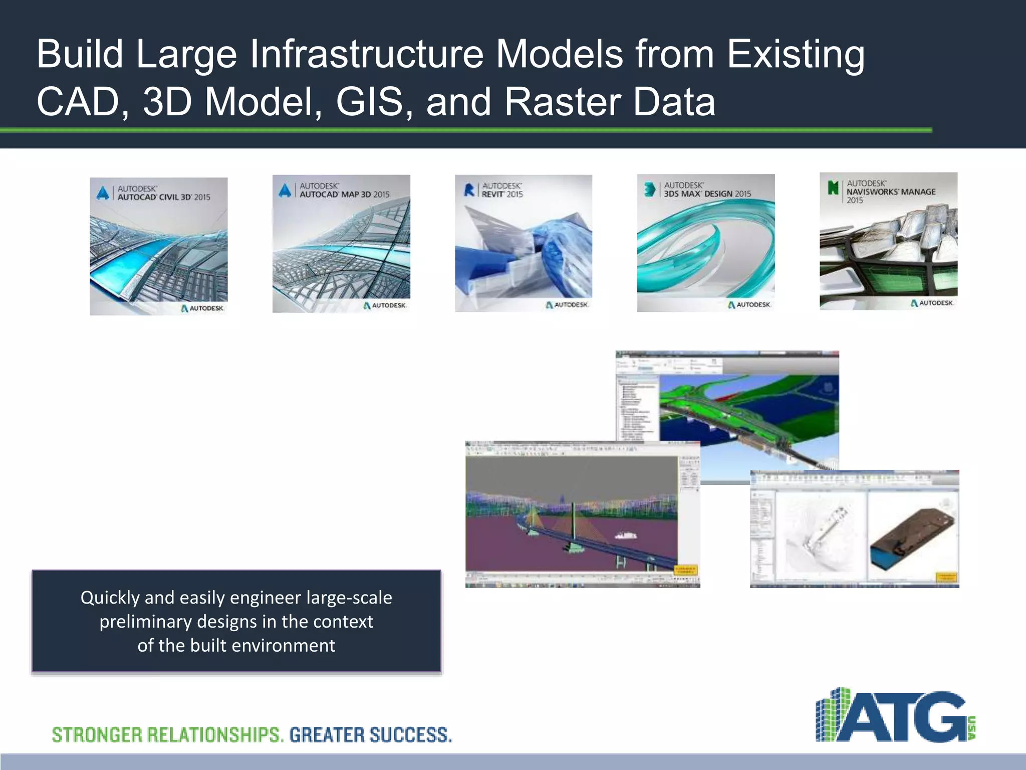
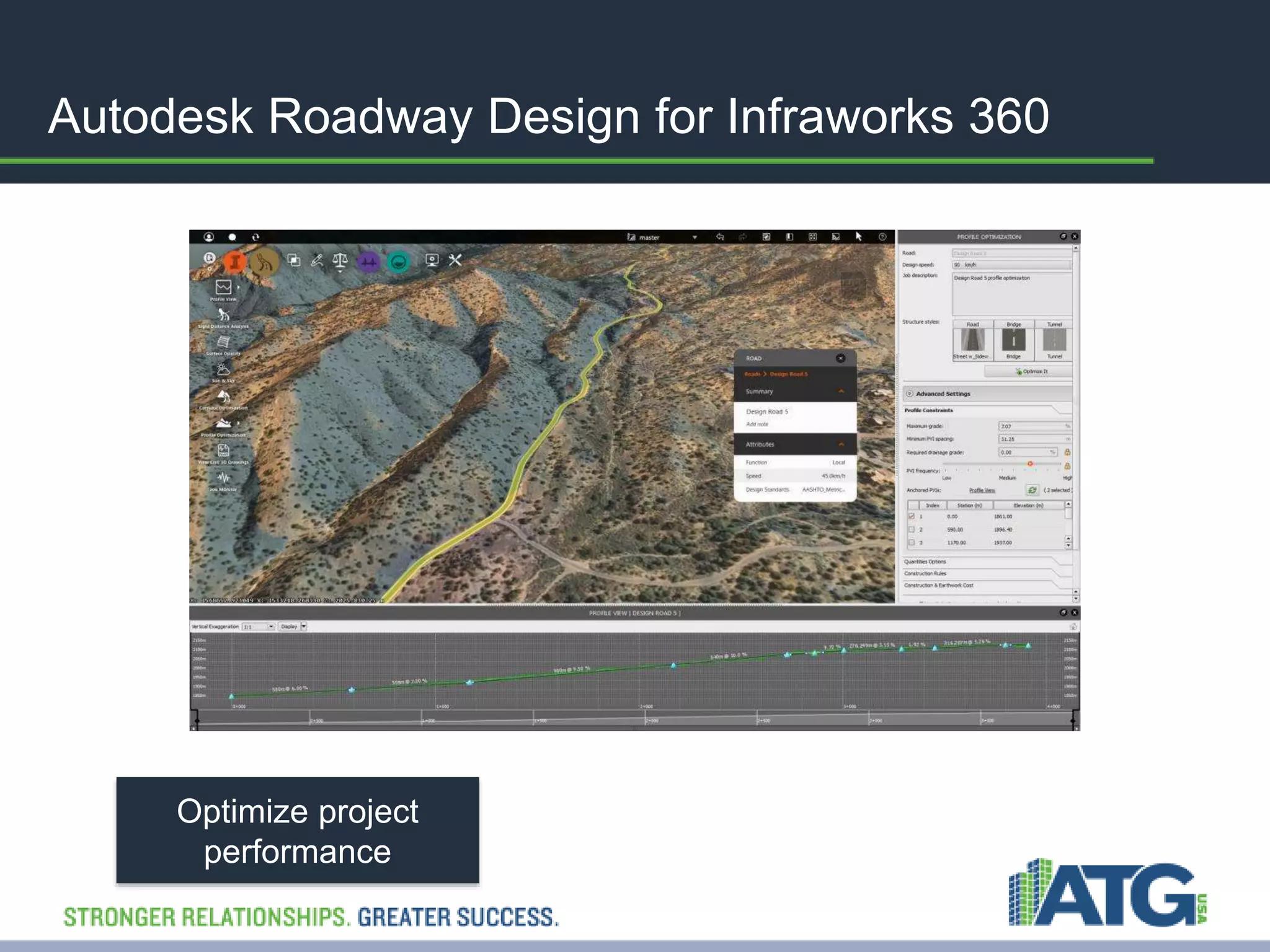
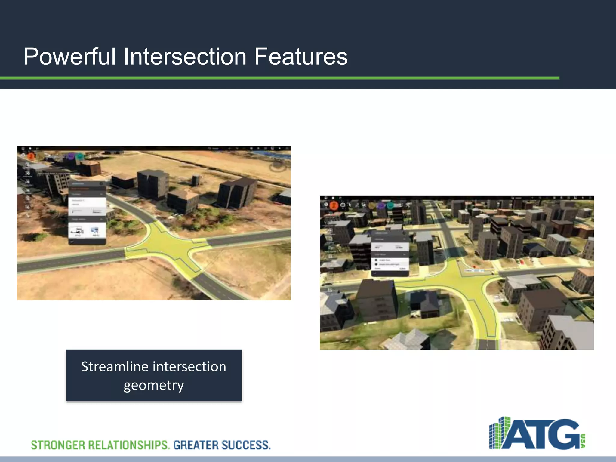
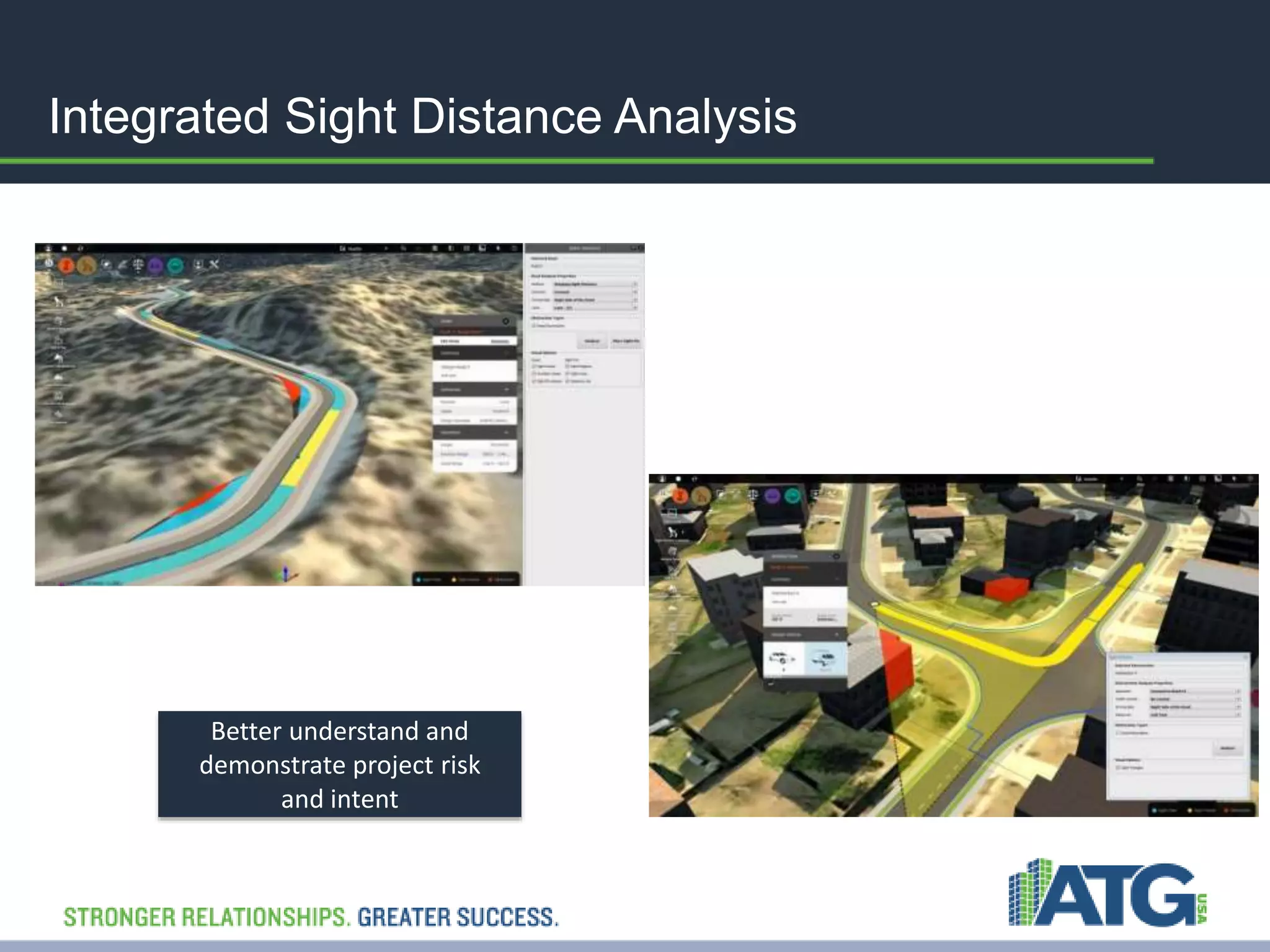
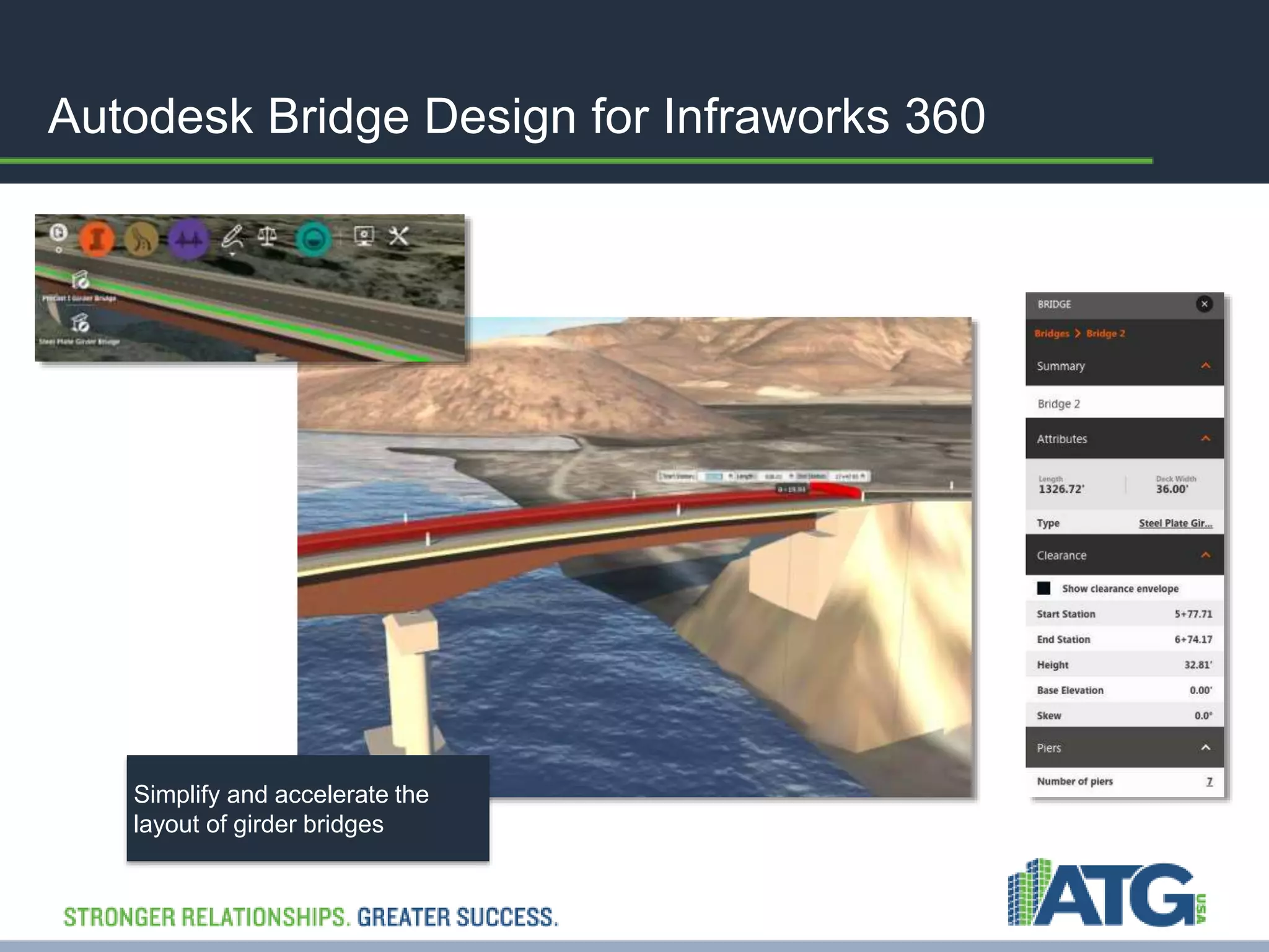
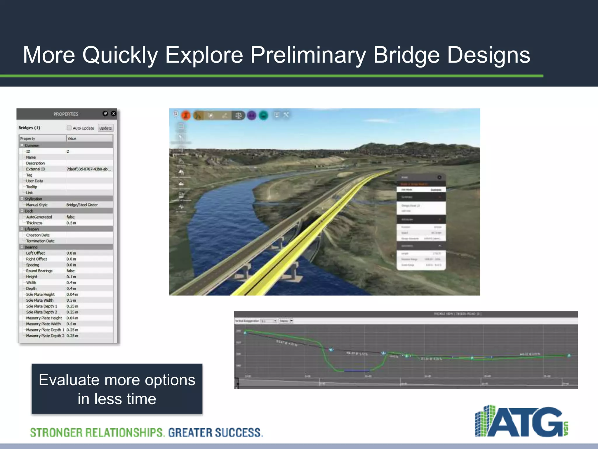
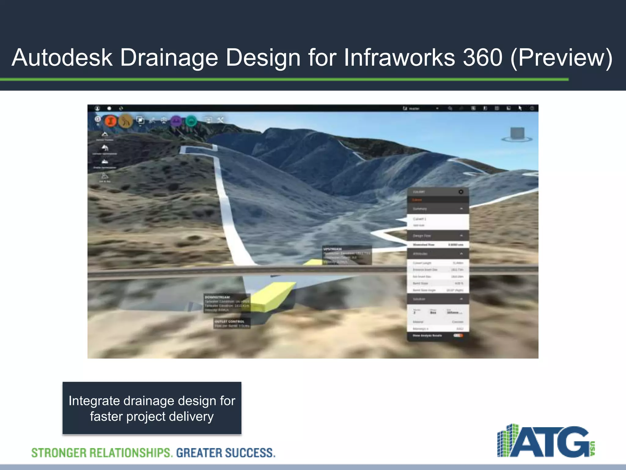
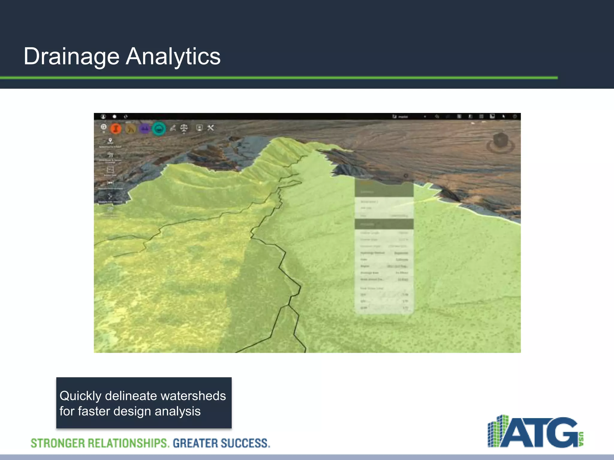
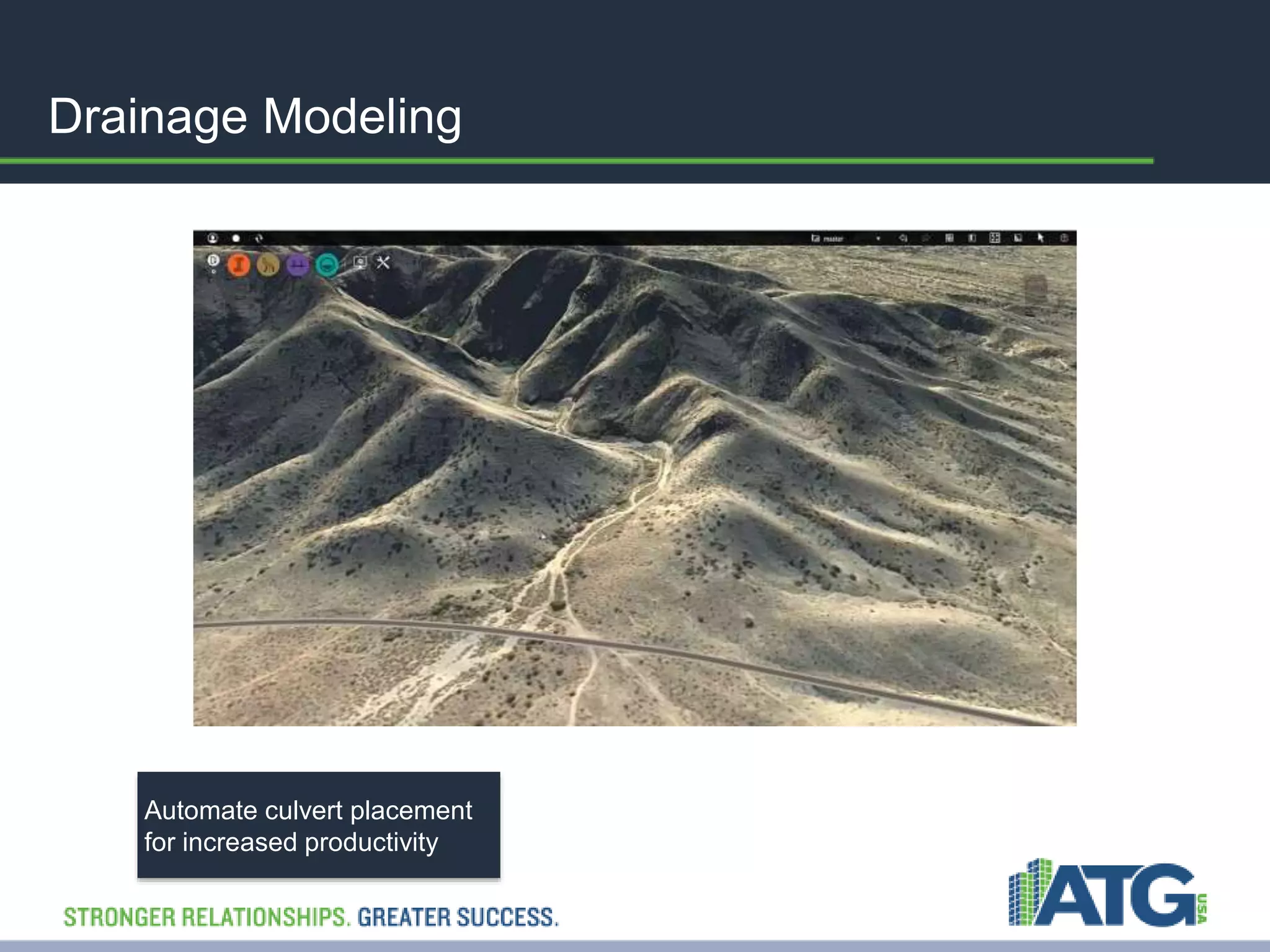
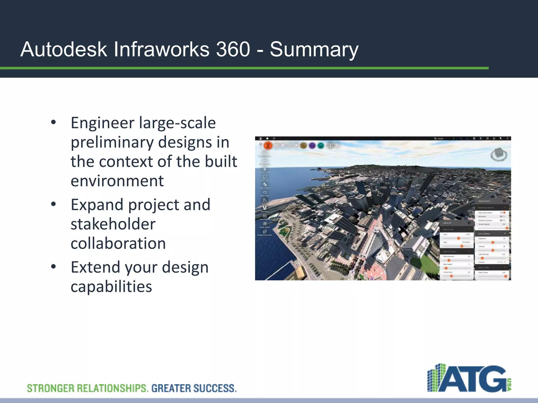
This Presentation would help you to explore Revit as a BIM tool and get you familiar with Revit features along with its usefulness & importance in the AEC industry. It is a brief presentation enlighting the important attributes of Revit software.
The purpose of this presentation is to give an understanding of the Methods, Plant and Sequence to construct an Airport.
This presentation can be used to engage Stakeholders and to get the Site Teams commitment to the programme. Also can be used for Site Induction Training and as a way to capture and share knowledge.
Project Execution Plan (PEP) details how a project will be executed, monitored and controlled.
High in Educational Value and easily understood. Recommended for Continuing Professional Development (CPD).
This Video Presentation is innovative and has many beneficial uses.
Can be used for Tender Presentations and to substantiate entitlement for additional payments.
This presentation shows how drones have been used successfully in construction and infrastructure asset management as aerial image and data capture devices thus far, review competitive and traditional approaches using incumbent technology, discuss the opportunities and challenges posed by the technology itself, outline the lessons learned, and discuss what’s next for drones in civil engineering.
What is Level of Definition?
When creating an information model as part of the #BIM process, you would not expect to have all your data collated right from day one. The aim is to deliver the right information, in the right format, to the right people at the right time.
A building information model contains both graphical and non-graphical information, accurately linked, clearly defined and well structured. As stages progress and proposals develop, the graphical and non-graphical data builds in a shared digital space, known as a Common Data Environment (#CDE). The different amounts of data are termed Levels of Definition.
Design and Development of BIM on GIS Interoperability Open Platformslhead1
ecently, Construction data has evolved from CAD to BIM and BIM becomes more important data used in various fields like facility management and 3D GIS construction, so there is an increasing need for developing technologies that can be effectively used in post-construction steps. There are lots of trials to model and service not only geographical terrain and outdoor but also indoor space. From this perspective, establishment of BIM and GIS interoperable method and development of service platform became the most important core technology. On this research, spatial data linkage model has been devised to smoothly implement the interoperability between two different kinds of data - BIM data and GIS data.
The platform basically displays BIM data based on 3D GIS such as WorldWind Java developed by NASA and Google Earth. It is also possible to interactively move in and out the buildings and also to see the outside of the building when a user is inside the building and inside of the building while a user is outside the building. Besides, the platform makes users look up the objects of buildings and properties of objects one by one, floor by floor, by similar properties, or all. Users can also edit the properties of objects and do spatial queries for analysis of the data.
This project is co research project of KICT(Korea Institute of Construction Technology) and Gaia3D and working closely together to develop BIM and GIS Interoperability Open-Platform for the integration of BIM and GIS data since 2012 and have developed the system for smooth operation of big size 3D BIM data and GIS data about plenty of buildings in areas or cities, not just one building. Now, core technologies to integrate BIM into GIS are successfully developed and we will keep improving the system step by step. KICT and Gaia3D together have designed and developed BIM and GIS interoperability open-platform based on the spatial data linkage model. Links between BIM data and GIS data enables efficient and seamless management of indoor and outdoor information at the same time and it also could be used for various services such as real estates and AR (Augmented Reality) services. Gaia3D develops 3D facility management system for Antarctic King Sejong science station to efficiently manage the facilities and publicly promote the station using BIM on GIS system with open source GIS software.
This is the basic knowledge of an IT Infrastructer.Which help to understand the requirment of IT ,Clients ,server and the work flow of the Information. The network connection and the Layars of OSI model to understand how the data is moving in a network.
Although cloud computing is an emerging field of computer science, the idea has been around for a few years. Cloud computing is ideally suited for engineering departments because it provides immediate access to flexible, real-time, high-performance computing resources configured in a way designers, engineers, and analysts need it, when they need it on a pay-as-you-go basis. Thus, cloud computing is an economical way to share data, conduct training sessions, and demonstrate software to prospects.
The leading 3D CAD vendors will discuss how their products facilitate cloud computing. By attending this special, free one-hour webinar, you will gain a better understanding of how cloud computing can help you work more efficiently.
Integrating Advanced Analytics with Autodesk SolutionsRich Hanapole
Learn how to integrate analytics software with Autodesk products to improve project visibility and communicate progress, issues and accomplishments to project stakeholders.
This class highlights proven approaches to design and integrate analytics into a project and demonstrates how stakeholders have the ability to view charts and trends including the ability to drill down into project data to identify challenge areas and apply corrective actions to improve the likelihood of a successful project outcome.
Webinar presentation July 23, 2015.
Big data technology increases the amount and variety of data that can be processed by analytics, providing a foundation for visualizations and insights that can significantly improve business operations.
The CSCC deliverable, Cloud Customer Architecture for Big Data and Analytics, discusses how harnessing cloud architectures can drastically improve big data and analytics capabilities. The paper explains how to host analytics solutions on the cloud.
Download the deliverable: http://www.cloud-council.org/resource-hub
Exploring Top Product Design Trends at Shalin DesignsShalin Designs
Discover 2023's top product design trends at Shalin Designs. From cutting-edge innovation to timeless aesthetics, stay ahead in the design game with our insightful guide. Elevate your creativity today! Check Now: https://shalindesigns.com/blog/product-design-trends/
Visualizing the engineering project lifecycle - Unite CopenhagenUnity Technologies
From design to operations, visualization is a powerful tool to drive informed decision-making on major projects. Point clouds, virtual reality and mobile apps are combining to enable better outcomes throughout the engineering industry. Join this session led by Aurecon to learn how Unity can empower engineers to increase efficiency and realize value through every stage of the project lifecycle.
Speaker: Michael Gardiner - Aurecon
Session available here: https://youtu.be/dixtTbGcCFg
5.2.2013 2013 2013 - Software, System, & IT Architecture - Good Design is G...IBM Rational
Series Name: Software, System, & IT Architecture
Webinar Name: 2013 - Software, System, & IT Architecture - Good Design is Good Business: Design Management: Pictures are Worth….
Date: May 2, 2013
Presneter: Roger Snook
Autodesk Recap Empowering Businesses with 3D Modellingamanraza23
Explore the power of Autodesk Recap for robust 3D modeling solutions. Revolutionize your business with advanced tools and seamless workflows, empowering teams to visualize, analyze, and collaborate like never before. From architectural designs to engineering projects, unlock new possibilities and drive innovation with Autodesk Recap at the helm of your ventures.
Field Activity Planner SaaS SW for the Digital OilfieldOlav Sylthe
Field Activity Planner is a SaaS SW for timeline 2D/3D visualization of dependencies and cost in work processes for offshore installations and marine operations. Thus allowing you to save time and money and moving into digital oilfield solutions available 24/7 in your browser.
Explore how Microsoft Azure can be used in extending your Dynamics 365 instances to support a rich set of business processes. We’ll compare options for building extensions such as a Service Bus, Worker Roles, Azure Functions and Microsoft Azure Logic Apps
Climate Science Flows: Enabling Petabyte-Scale Climate Analysis with the Eart...Globus
The Earth System Grid Federation (ESGF) is a global network of data servers that archives and distributes the planet’s largest collection of Earth system model output for thousands of climate and environmental scientists worldwide. Many of these petabyte-scale data archives are located in proximity to large high-performance computing (HPC) or cloud computing resources, but the primary workflow for data users consists of transferring data, and applying computations on a different system. As a part of the ESGF 2.0 US project (funded by the United States Department of Energy Office of Science), we developed pre-defined data workflows, which can be run on-demand, capable of applying many data reduction and data analysis to the large ESGF data archives, transferring only the resultant analysis (ex. visualizations, smaller data files). In this talk, we will showcase a few of these workflows, highlighting how Globus Flows can be used for petabyte-scale climate analysis.
Paketo Buildpacks : la meilleure façon de construire des images OCI? DevopsDa...Anthony Dahanne
Les Buildpacks existent depuis plus de 10 ans ! D’abord, ils étaient utilisés pour détecter et construire une application avant de la déployer sur certains PaaS. Ensuite, nous avons pu créer des images Docker (OCI) avec leur dernière génération, les Cloud Native Buildpacks (CNCF en incubation). Sont-ils une bonne alternative au Dockerfile ? Que sont les buildpacks Paketo ? Quelles communautés les soutiennent et comment ?
Venez le découvrir lors de cette session ignite
TROUBLESHOOTING 9 TYPES OF OUTOFMEMORYERRORTier1 app
Even though at surface level ‘java.lang.OutOfMemoryError’ appears as one single error; underlyingly there are 9 types of OutOfMemoryError. Each type of OutOfMemoryError has different causes, diagnosis approaches and solutions. This session equips you with the knowledge, tools, and techniques needed to troubleshoot and conquer OutOfMemoryError in all its forms, ensuring smoother, more efficient Java applications.
Enterprise Resource Planning System includes various modules that reduce any business's workload. Additionally, it organizes the workflows, which drives towards enhancing productivity. Here are a detailed explanation of the ERP modules. Going through the points will help you understand how the software is changing the work dynamics.
To know more details here: https://blogs.nyggs.com/nyggs/enterprise-resource-planning-erp-system-modules/
Experience our free, in-depth three-part Tendenci Platform Corporate Membership Management workshop series! In Session 1 on May 14th, 2024, we began with an Introduction and Setup, mastering the configuration of your Corporate Membership Module settings to establish membership types, applications, and more. Then, on May 16th, 2024, in Session 2, we focused on binding individual members to a Corporate Membership and Corporate Reps, teaching you how to add individual members and assign Corporate Representatives to manage dues, renewals, and associated members. Finally, on May 28th, 2024, in Session 3, we covered questions and concerns, addressing any queries or issues you may have.
For more Tendenci AMS events, check out www.tendenci.com/events
Check out the webinar slides to learn more about how XfilesPro transforms Salesforce document management by leveraging its world-class applications. For more details, please connect with sales@xfilespro.com
If you want to watch the on-demand webinar, please click here: https://www.xfilespro.com/webinars/salesforce-document-management-2-0-smarter-faster-better/
Custom Healthcare Software for Managing Chronic Conditions and Remote Patient...Mind IT Systems
Healthcare providers often struggle with the complexities of chronic conditions and remote patient monitoring, as each patient requires personalized care and ongoing monitoring. Off-the-shelf solutions may not meet these diverse needs, leading to inefficiencies and gaps in care. It’s here, custom healthcare software offers a tailored solution, ensuring improved care and effectiveness.
Into the Box Keynote Day 2: Unveiling amazing updates and announcements for modern CFML developers! Get ready for exciting releases and updates on Ortus tools and products. Stay tuned for cutting-edge innovations designed to boost your productivity.
OpenFOAM solver for Helmholtz equation, helmholtzFoam / helmholtzBubbleFoamtakuyayamamoto1800
In this slide, we show the simulation example and the way to compile this solver.
In this solver, the Helmholtz equation can be solved by helmholtzFoam. Also, the Helmholtz equation with uniformly dispersed bubbles can be simulated by helmholtzBubbleFoam.
AI Pilot Review: The World’s First Virtual Assistant Marketing SuiteGoogle
AI Pilot Review: The World’s First Virtual Assistant Marketing Suite
👉👉 Click Here To Get More Info 👇👇
https://sumonreview.com/ai-pilot-review/
AI Pilot Review: Key Features
✅Deploy AI expert bots in Any Niche With Just A Click
✅With one keyword, generate complete funnels, websites, landing pages, and more.
✅More than 85 AI features are included in the AI pilot.
✅No setup or configuration; use your voice (like Siri) to do whatever you want.
✅You Can Use AI Pilot To Create your version of AI Pilot And Charge People For It…
✅ZERO Manual Work With AI Pilot. Never write, Design, Or Code Again.
✅ZERO Limits On Features Or Usages
✅Use Our AI-powered Traffic To Get Hundreds Of Customers
✅No Complicated Setup: Get Up And Running In 2 Minutes
✅99.99% Up-Time Guaranteed
✅30 Days Money-Back Guarantee
✅ZERO Upfront Cost
See My Other Reviews Article:
(1) TubeTrivia AI Review: https://sumonreview.com/tubetrivia-ai-review
(2) SocioWave Review: https://sumonreview.com/sociowave-review
(3) AI Partner & Profit Review: https://sumonreview.com/ai-partner-profit-review
(4) AI Ebook Suite Review: https://sumonreview.com/ai-ebook-suite-review
Field Employee Tracking System| MiTrack App| Best Employee Tracking Solution|...informapgpstrackings
Keep tabs on your field staff effortlessly with Informap Technology Centre LLC. Real-time tracking, task assignment, and smart features for efficient management. Request a live demo today!
For more details, visit us : https://informapuae.com/field-staff-tracking/
Exploring Innovations in Data Repository Solutions - Insights from the U.S. G...Globus
The U.S. Geological Survey (USGS) has made substantial investments in meeting evolving scientific, technical, and policy driven demands on storing, managing, and delivering data. As these demands continue to grow in complexity and scale, the USGS must continue to explore innovative solutions to improve its management, curation, sharing, delivering, and preservation approaches for large-scale research data. Supporting these needs, the USGS has partnered with the University of Chicago-Globus to research and develop advanced repository components and workflows leveraging its current investment in Globus. The primary outcome of this partnership includes the development of a prototype enterprise repository, driven by USGS Data Release requirements, through exploration and implementation of the entire suite of the Globus platform offerings, including Globus Flow, Globus Auth, Globus Transfer, and Globus Search. This presentation will provide insights into this research partnership, introduce the unique requirements and challenges being addressed and provide relevant project progress.
Large Language Models and the End of ProgrammingMatt Welsh
Talk by Matt Welsh at Craft Conference 2024 on the impact that Large Language Models will have on the future of software development. In this talk, I discuss the ways in which LLMs will impact the software industry, from replacing human software developers with AI, to replacing conventional software with models that perform reasoning, computation, and problem-solving.
First Steps with Globus Compute Multi-User EndpointsGlobus
In this presentation we will share our experiences around getting started with the Globus Compute multi-user endpoint. Working with the Pharmacology group at the University of Auckland, we have previously written an application using Globus Compute that can offload computationally expensive steps in the researcher's workflows, which they wish to manage from their familiar Windows environments, onto the NeSI (New Zealand eScience Infrastructure) cluster. Some of the challenges we have encountered were that each researcher had to set up and manage their own single-user globus compute endpoint and that the workloads had varying resource requirements (CPUs, memory and wall time) between different runs. We hope that the multi-user endpoint will help to address these challenges and share an update on our progress here.
Understanding Globus Data Transfers with NetSageGlobus
NetSage is an open privacy-aware network measurement, analysis, and visualization service designed to help end-users visualize and reason about large data transfers. NetSage traditionally has used a combination of passive measurements, including SNMP and flow data, as well as active measurements, mainly perfSONAR, to provide longitudinal network performance data visualization. It has been deployed by dozens of networks world wide, and is supported domestically by the Engagement and Performance Operations Center (EPOC), NSF #2328479. We have recently expanded the NetSage data sources to include logs for Globus data transfers, following the same privacy-preserving approach as for Flow data. Using the logs for the Texas Advanced Computing Center (TACC) as an example, this talk will walk through several different example use cases that NetSage can answer, including: Who is using Globus to share data with my institution, and what kind of performance are they able to achieve? How many transfers has Globus supported for us? Which sites are we sharing the most data with, and how is that changing over time? How is my site using Globus to move data internally, and what kind of performance do we see for those transfers? What percentage of data transfers at my institution used Globus, and how did the overall data transfer performance compare to the Globus users?
Providing Globus Services to Users of JASMIN for Environmental Data AnalysisGlobus
JASMIN is the UK’s high-performance data analysis platform for environmental science, operated by STFC on behalf of the UK Natural Environment Research Council (NERC). In addition to its role in hosting the CEDA Archive (NERC’s long-term repository for climate, atmospheric science & Earth observation data in the UK), JASMIN provides a collaborative platform to a community of around 2,000 scientists in the UK and beyond, providing nearly 400 environmental science projects with working space, compute resources and tools to facilitate their work. High-performance data transfer into and out of JASMIN has always been a key feature, with many scientists bringing model outputs from supercomputers elsewhere in the UK, to analyse against observational or other model data in the CEDA Archive. A growing number of JASMIN users are now realising the benefits of using the Globus service to provide reliable and efficient data movement and other tasks in this and other contexts. Further use cases involve long-distance (intercontinental) transfers to and from JASMIN, and collecting results from a mobile atmospheric radar system, pushing data to JASMIN via a lightweight Globus deployment. We provide details of how Globus fits into our current infrastructure, our experience of the recent migration to GCSv5.4, and of our interest in developing use of the wider ecosystem of Globus services for the benefit of our user community.
Providing Globus Services to Users of JASMIN for Environmental Data Analysis
Infraworks360 Overview
1. Introducing – Autodesk Infraworks 360
Engineer large-scale preliminary designs in the context
of the built environment
Expand project and stakeholder collaboration
Extend your design capabilities
2. Today’s Business Challenges
• Strong competition
• Inefficient and fragmented workflows
• Gaining commitment from stakeholders
How do you overcome these
challenges?
3. What if you could…
Provide real -
world context
Create and
visualize data rich
models from GIS,
CAD, and reality
capture data in
minutes to provide
context for designs
like never before
Explore design
alternatives
Efficiently
produce and
iterate on
accurate and
realistic design
proposals to
explore
alternatives, then
leverage them for
preliminary
engineering
Make informed
decisions
Utilize analytics
and simulation to
understand
conditions,
evaluate design
proposals to make
informed decisions
faster
Increase project
understanding
Share models and
proposals with
collaborators and
stakeholders
virtually anytime,
anywhere,
increasing project
understanding and
reducing costs
Accelerate
approvals
Present design
intent in realistic
3D context to
accelerate
approvals
4. 1 – Engineer Large-scale Infrastructure Models
Create models from existing data
Securely publish, store, and
manage large infrastructure
models
Use existing conditions to inform planning and
design concepts.
5. Build Large Infrastructure Models from Existing
CAD, 3D Model, GIS, and Raster Data
Quickly and easily engineer large-scale
preliminary designs in the context
of the built environment
6. 2 – Expand Project and Stakeholder Collaboration
Create stunning
visualizations for
proposals
Better communicate
concepts
Visualize concepts from
web and mobile
Differentiate your services,
make information available 24/7, and
help to ease public concerns over project
changes or timelines.
15. Autodesk Infraworks 360 - Summary
• Engineer large-scale
preliminary designs in
the context of the built
environment
• Expand project and
stakeholder
collaboration
• Extend your design
capabilities
16. With Autodesk® software
and services, you can win
more work and deliver
projects with more
predictability and less risk.
Editor's Notes
Autodesk® InfraWorks 360™ software expands Building information Modeling (BIM) workflows by enabling infrastructure and building professionals to go beyond basic model creation, sketching, and visualization to engineering, collaboration, and analysis.
More quickly and easily engineer large-scale preliminary designs in the context of the built environment using a single model that can contain significant amounts of data from a wide range of sources.
Advance and accelerate project development by creating and sharing scenarios and project proposals using a more secure, reliable cloud service that allows for additional viewing and editing across disciplines, offices, and stakeholders.
Extend your design capabilities with the ability to access specialized tools for roadway, drainage, and bridge design.
There are several business challenges we often hear about and they primarily focus on winning new business, and increasing efficiency and productivity. Here is what we have learned:
In an economy where they are fewer projects and tighter budget constraints winning new business requires that you standout from your competition. How do you differentiate what you can offer your prospects and existing clients?
Companies are concerned with the money they often lose as they try to capture new business. It can be expensive to create multiple alternatives for a new client and to demonstrate that you understand what the customer is asking for.
And for the projects they are already working on businesses see inefficiencies throughout the lifecycle of the project that hurt their productivity. Whether it is time spent on finding and incorporating the data they need to build the model, or the costs of change orders- they see areas for improvement.
Communicating with project team members, and external, often non-technical stakeholders presents its own set of challenges. When someone doesn’t understand the design intent a great deal of time is wasted getting to yes.
Do these business challenges sound familiar to you? What are you trying to improve?
What if you could solve those business challenges with the ability to:
Create your models in the context of today’s environment.
Quickly and easily explore multiple design alternatives to ensure you are making the right choice. Give your client options to choose from with the ability to re-use the chosen design in the preliminary engineering phase.
Make smarter decisions about how your model will perform using analytics and simulations that don’t send your projects over budget.
Share designs with internal and external stakeholders, even the non-technical ones, in easy to understand models that ultimately help accelerate the approval process. Your stakeholder would no longer have to ask how your design would look in real life, because you could show them.
Preliminary design and engineering is an important, often forgotten, phase in the lifecycle of an infrastructure project and can benefit from BIM for Infrastructure workflows. Work completed between the planning and design phases is needed to confirm scope, budget, and schedule. Autodesk InfraWorks 360 provides added value to civil infrastructure projects in this phase.
Create models from existing data: Using open-source Feature Data Object (FDO) technology, InfraWorks 360 supports spatial data from a variety of sources, including:
ESRI® SHP files, Oracle, Microsoft SQL Server, PostGIS, PostgreSQL, SQLite, MySQL™, and ESRI® ArcSDE® managed databases
3D DGN, IFC, and Sketchup (SKP)
InfraWorks 360 also supports importing data from a 3D laser scan and other reality capture files that have been converted to RCS format (Autodesk® ReCap software can be used to generate this file).
Improved CityGML supports schema location, building asset mapping, and self-intersecting geometry.
Finally, for some data sources, you can choose cloud or local import based on your preference or project requirements.
Import data from other Autodesk technology (We will cover this in more detail on the next slide)
You can create and manage large-scale models from existing data sources and more securely publish, store and manage them.
Greatly improve your ability to incorporate detailed data from existing CAD, 3D model, GIS, CityGML, and raster data—again, allowing existing conditions to inform the design concepts.
Incorporate detailed models from:
Autodesk AutoCAD Civil 3D software and specifically LandXML and IMX formats, as well as numerous terrain and imagery file formats, including Mr.SID, ECW, and georeferenced TIFF files
Autodesk AutoCAD Map 3D
Autodesk Revit software products and Autodesk FBX file format is also supported; Revit .rvt files can be imported directly.
Autodesk 3ds Max Design, and Autodesk Navisworks software products, among others.
Let’s talk about the need to be able to communicate in new ways. On one hand, our clients have told us that to address the increasing complexity and to stay competitive they are putting a lot of time and effort into creating proposals—they need to win work in order to make money.
Once a project is won, growing project complexity is complicated by changing technology where social networks and crowdsourcing are commonplace. The growing social climate means customers need to be able to communicate to a broader audience—our customers are telling us that public involvement can result in an increase in project cost and can even shut down a project.
And there are many ways that your stakeholders can get engaged now because they can visualize these concepts from web and mobile.
Field teams can provide real-time comments to project teams to support decisions made in the office by accessing project proposals nearly anytime and anywhere. More quickly arrive at an effective solution with minimal debate because decisions are backed by information and field validation.
Adding to the power of Autodesk InfraWorks 360, Autodesk Roadway Design for InfraWorks 360 helps civil engineering professionals working on transportation projects explore preliminary design options and optimize project performance by more efficiently and effectively engineering roadway geometry in the context of the existing environment.
Roadway Design for InfraWorks 360 enables functionality that complements current planning and design workflows. Civil engineering teams can help streamline horizontal and vertical roadway geometry layout, including the design of intersections, using a powerful rules-based toolset. More effectively document and share design alternatives with project stakeholders via cloud services. Help accelerate the overall design process by importing the preferred alternative into Autodesk® AutoCAD® Civil 3D® 2015 software to continue detailed design work.
Let’s continue to explore how Roadway Design for InfraWorks 360 enables you to engineer early design concepts in context.
Tools in the software enable you to use standard design vehicles to define intersection geometry. This ability helps streamline intersection geometry layout with discipline-specific authoring tools that incorporate parametric controls, support engineering standards, and provide design validation rules.
Flexible editing tools enable faster and easier design changes.
Considerations for safety need to be made even at the earliest stages of project development.
With Roadway Design for InfraWorks 360, you’re working with a more precise model of what truly exists at the project site, so you are able to better consider safety requirements early in project development by analyzing sight distances, including stopping sight, with a 3D model versus the traditional methods that consider only vertical profiles.
Using the 3D model you’ll be able to help identify:
Blind spots and sight distance failure zones
Demonstrate desired and actual sight envelopes
Identify causes for driver sight obstructions
Adding to the power of Autodesk InfraWorks 360, Autodesk Bridge Design for InfraWorks 360 software helps you more effectively explore preliminary bridge design options as part of your overall roadway designs by modeling and visualizing realistic civil structures in the context of the surrounding proposed site. Bridge Design for InfraWorks 360 takes advantage of a robust, data-rich model and a rules-based workflow, helping to simplify, accelerate, and focus the layout of girder bridge design concepts, as well as helping to maintain consistent data and context between highway and bridge engineers. Let’s take a closer look.
Bridge Design enables you to more quickly evaluate bridge design options using a parametric workflow. The advantage of the workflow is that while you focus on a few key inputs the software will update other areas of the bridge model in an intelligent manner. For example, by simply changing the number of lanes for the road, the number of girders and the pier layouts adjust automatically.
The Autodesk Drainage Design preview provides the drainage design tools you need for your transportation projects. Analyze watershed hydrology using USGS National Stream State regression equations. Now you can layout, size and design preliminary culverts directly in the InfraWorks 360 model.
Delineate watersheds (using Watershed Analysis preview)
Watershed Analysis for InfraWorks 360 cloud service (preview) delineates watersheds and streams across large terrain surfaces. The analysis examines the terrain model to find the watershed tributary to a single point location or to locate all of the watersheds that are tributary to a portion of a design road with runoff calculations and peak flow Q values. The resulting terrain analytics provide the crossing streams and the tributary watersheds for use in cross-drainage design.
Culvert design and analysis calculations size and compute culvert hydraulics. Rules determine initial culvert solution. Designs are resized for culvert configuration changes.
Drainage Modeling
Automate culvert placement at linear waterway crossings using pre-determined rules.
Drainage modeling is associated with road layout and locations are adjusted as roads change
Assign a USGS National Stream State Regression equation and parameters to compute the runoff from the defined watershed
Pipelines and connector data from InfraWorks 360 now goes with appropriate elevation, offset and size information into Civil 3D through IMX
Autodesk InfraWorks 360 gives you the tools you need to engineer preliminary design in context---giving you the ability to see your design as it would perform in today’s existing environment. You can rapidly build models and then share parts of the model or all of the model using a secure cloud service that enables your extended project team and public stakeholders to access the model.
And with InfraWorks 360 you have the platform to extend your design capabilities and access specialized tools for road, bridge, and drainage design projects.