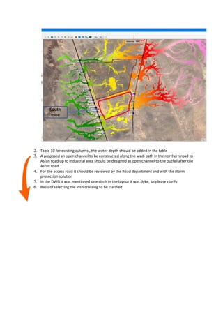
The document provides details on proposed infrastructure improvements for a hydrologic study area, including:
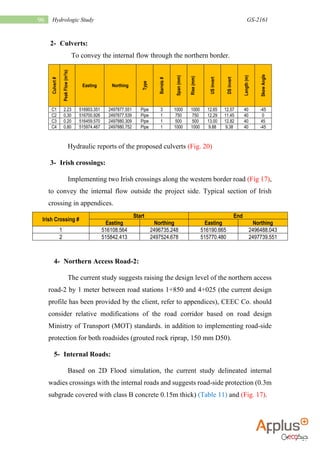
1) Culverts to convey internal water flow through the northern border. Details on 4 proposed culverts are provided.
2) Two proposed Irish crossings along the western border road to convey internal water flow outside the project area.
3) Raising the design level of the northern access road between stations 1+850 and 4+025 by 1 meter, with modifications based on road design standards and roadside protection implemented.
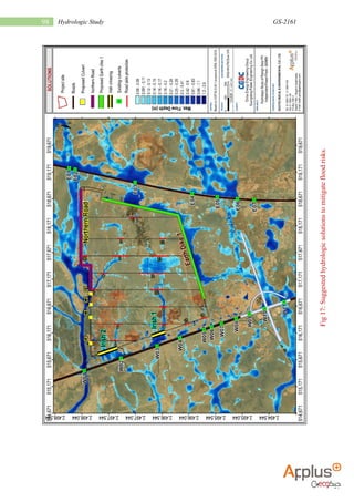
4) Delineation of internal wadies crossings with internal roads based on flood simulation, with recommendations for roadside protection. A table lists 16 proposed road segments and lengths.
Presentation for DHA on project progress(08-09-22).pptxFaisalGulzar19
The presentation summarizes the progress of the Infrastructure Development Works Package 2-B project in DHA Gujranwala. Key points include:
- Planned progress is 32.13% but achieved progress is 20% due to monsoon rains, design revisions causing delays, and increased scope of work.
- A look ahead plan outlines balancing the work schedule to meet planned progress targets over the coming months through deployment of equipment and manpower resources.
- Financial progress and a balance work schedule provide details on completion status and planned progress by item through October 2023 to complete the project.
This document provides details of a highway construction project undertaken by Apco Infratech Pvt. Ltd. It summarizes the key project details including the client (IL & FS), location (Barwa-Adda-Panagarh section of NH-2 in Jharkhand and West Bengal), scope (6-laning of 43.325 km road), and contract value (Rs. 488 crores). It then provides progress updates on the status of road widening and structure construction works. Tables outline the monthly work planned and progress achieved between November 2015 to March 2016. Overall, it reports on the construction and management of a major highway project.
This document provides details of a highway design senior project located in eastern Ethiopia. It includes an introduction describing the need for well-trained engineers and objectives of exposing students to practical design projects. It then gives a brief description of the project area along the Hargele-Afder-Bare-Yet road and scope of the project. The next section focuses on geometric design, including terrain classification, design traffic volumes, functional classification, design standards, and computation of elements for the first horizontal curve.
This document provides a conceptual study for a proposed 330 km iron concentrate slurry pipeline from Mt Reed to Port Cartier, Quebec. Key aspects of the proposed system include:
- A 28" diameter steel pipeline operating at 1.7-1.8 m/s, carrying 24 Mt/y of 65% solids iron concentrate slurry
- Two pump stations, one at the mine site and one intermediate, using positive displacement pumps
- Agitated storage tanks at the mine site, intermediate station, and terminal for continuity of operations
- Cathodic protection, leak detection, and a SCADA system to monitor and control the pipeline
The study concludes the pipeline system is technically feasible. Further optimization and testing are
GHD Flood Mapping Review City of Stonnington 2008Stonnington
This document provides a report on revisions to flood plain mapping for the City of Stonnington. It summarizes the scope of the revision project, which involved updating mapping in 5 areas (Packages 1-5) based on new drainage information and flood reports. The report describes the methodology used, including hydraulic modeling updates, field inspections, and new aerial survey data. Maps and GIS data layers of updated flood extents will be delivered.
The document summarizes the project description for the GASCO Abr Sinai Onshore Gas Pipeline in Egypt. It includes:
- The 111km pipeline route from El-Tena East to El-Areish, split into two loops from KM 0-33 and KM 78.
- Pipeline specifications including diameter, material, gas flow rates and specifications.
- Time schedule, number of personnel, equipment, and construction process from right of way to commissioning.
- Pipeline laying technique using three side booms to lower the pipe into the trench in a gentle S-curve.
The document provides an executive summary of a detailed project report for the improvement of the Akhnoor-Poonch Road in Jammu and Kashmir, India. The Border Roads Organization has appointed a consultant to conduct a feasibility study and prepare the report to upgrade the existing road to a two-lane or four-lane configuration. The report will include design of the highway, pavement, bridges and structures, as well as cost estimates and economic analysis. The scope of work involves surveys, design, environmental assessment, cost estimation, and preparation of the feasibility and detailed project reports.
Improvement and Asphalting of State Highway and Major District Road of Koppal...IRJET Journal
This document summarizes a study on improving and asphalting sections of state highway SH-63 and major district road in Koppal District, Karnataka, India. Field studies were conducted to determine existing road conditions and traffic volumes. For the 8.1 km section of SH-63 from Mudhol to Hiremyageri, 4.6 km was proposed for reconstruction and 3.5 km for resurfacing. For the 7.75 km section of major district road from Mannapur to Kukanur, detailed designs and cost estimates were developed. The proposed improvements are needed due to deterioration of the existing pavement and increasing traffic from vehicles such as granite trucks and agricultural vehicles. The total estimated cost for improving both
This document outlines standards and procedures for transmission line route surveys. It discusses responsibilities, survey methods, drawings, and other documentation required. Some key points:
- The contractor is responsible for selecting the transmission line route based on criteria like minimum length, cost, and environmental impact. They must perform preliminary and detailed surveys.
- Surveying methods include establishing angle points, profiling the terrain, and noting obstacles. Data is recorded on plan and profile drawings.
- Drawings include general layouts, detailed plans and profiles, and crossings. Profile stationing starts from the power source.
- The contractor must ensure accurate structure placement within specified tolerances based on the survey data.
Final Compiled GM Presentation on 18.05.2022 Updated.pptxIESGATEWiz
1) Works are underway at Subedarganj station to develop two washing pit lines and a stabling line. Civil works are nearly complete for the washing pits and stabling line, while electrical and S&T works are ongoing.
2) Replacement of the existing washing pit at Prayagraj is under construction, with the civil works nearly complete for one pit. A second pit will require 9-10 additional months to construct once the first pit is handed over.
3) Extension of looping lines is progressing at Jhansi and Dabhaura stations, with track linking and electrical works ongoing. Completion is targeted by June 2022 once remaining works are completed.
The document identifies errors in Example Problem 4.8 in the publication "Introduction to Highway Hydraulics". It lists several corrections that need to be made to equations, values, and text in the example problem. The corrections are related to unit conversion errors between SI and English units that resulted in incorrect velocities, Froude numbers, sequent depths, and text in the example. This list was prepared to document all known needed corrections as of August 20, 2012.
This document provides an overview of bridge deck drainage design. It discusses key design objectives such as minimizing water spread and avoiding hydroplaning. It describes typical system components like deck gutters, inlets, pipes, and end collectors. It provides methods for estimating design storm runoff and guidance on flow in gutters. The document discusses factors that affect inlet interception capacity and efficiency. It also provides design considerations for the underdeck collection system and bridge end collectors. The overall document aims to guide the design of effective bridge deck drainage systems.
This document provides an overview of the Sigma Six model used to analyze cracking in the Arbaminch-Wolaita-Sodo Federal Road project in Ethiopia. It describes the project and outlines the DMAIC improvement cycle phases: Define, Measure, Analyze, Improve, Control. In the Define phase, tools like a project charter and value stream mapping were used. Road cracking is defined, with specific focus on factors that cause pothole cracking like rainfall, temperature, soil drainage, materials used, traffic load, and plants/trees. Models are presented to simulate the effects of these factors on flexible pavement cracking.
This document contains diagrams and tables related to determining the maximum height of buildings based on wind speed factors. Diagram 6 shows a map of wind speeds in various regions. Table a provides a Factor O based on the orographic zone and slope of the terrain at a site. Factor O is used to calculate Factor S, which combines wind speed, terrain, and orography to determine the appropriate building height restrictions in Table c. The maximum allowable building height decreases as the Factor S increases due to higher wind speeds and steeper terrain.
#تواصل_تطوير
المحاضرة رقم 187
أستاذ دكتور / مدحت كمال عبدالله
عنوان المحاضرة:
تدعيم كباري باستخدام التفاعل المشترك
للمياه - جسم الكوبري
وعرض حالة عملية
Temporary Support Of Existing Bridges Using
Water-Structure Interaction
including case study
يوم الإثنين 26 ديسمبر 2022
الثامنة مساء توقيت القاهرة
التاسعة مساء توقيت مكة المكرمة
و الحضور عبر تطبيق زووم من خلال الرابط
https://us02web.zoom.us/meeting/register/tZModeusrzsoHtbqmSpzcaX1yPR0TmfeoAQl
علما ان هناك بث مباشر للمحاضرة على القنوات الخاصة بجمعية المهندسين المصريين
ونأمل أن نوفق في تقديم ما ينفع المهندس ومهمة الهندسة في عالمنا العربي
والله الموفق
للتواصل مع إدارة المبادرة عبر قناة التليجرام
https://t.me/EEAKSA
ومتابعة المبادرة والبث المباشر عبر نوافذنا المختلفة
رابط اللينكدان والمكتبة الالكترونية
https://www.linkedin.com/company/eeaksa-egyptian-engineers-association/
رابط قناة التويتر
https://twitter.com/eeaksa
رابط قناة الفيسبوك
https://www.facebook.com/EEAKSA
رابط قناة اليوتيوب
https://www.youtube.com/user/EEAchannal
رابط التسجيل العام للمحاضرات
https://forms.gle/vVmw7L187tiATRPw9
ملحوظة : توجد شهادات حضور مجانية لمن يسجل فى رابط التقيم اخر المحاضرة.
Response of Segmental Bridge when Subjected to Seismic ExcitationIRJET Journal
This document summarizes research analyzing the response of a segmental bridge subjected to seismic excitation. Key points:
- The designed segmental bridge was 8.8m wide, 2m deep and 31m long with M50 grade concrete.
- The bridge's response was analyzed for different seismic zones in India using various methods like the Indian code IS 1893(Part 1) 2002, force-based design and displacement-based design.
- Results like base shear, bending moment, stress and displacement were calculated and compared for different soil types including rock, gravel and silt/clay.
- Response was also analyzed for actual earthquake occurrences by calculating parameters like earthquake force, time period, frequency, displacement and
The document provides cost estimates for redevelopment and landscaping of four parks in Varanasi, India over five years. It includes bill of quantities and cost breakdowns for Gulab Bagh Park, which is estimated to cost a total of 7,174,327.55 Indian rupees. The costs cover civil works, electrical works, drainage, landscaping, maintenance and other miscellaneous works. Detailed cost items are provided for excavation, concrete, reinforcement, brickwork and other construction activities.
Photovoltaic Training Course - Module 2.1 - Civil worksLeonardo ENERGY
Civil works are an important part of ground-mounted photovoltaic projects. They include terrain leveling, access roads, and trench excavation. Well-planned civil works can reduce costs and environmental impacts. Access roads should consider vehicle size and turning radii. Trenches should be dug every 40 meters and changes in direction, and bury photovoltaic cables with caution tape and sometimes concrete topping. Proper civil works preparation is key to successful photovoltaic project execution and commissioning.
This document is a training report submitted for partial fulfillment of a Bachelor of Technology degree in Civil Engineering. It details a project on road widening and upgradation of the 41 km Chandauli-Saidpur road (SH-69) in Uttar Pradesh, India. The report includes an acknowledgment, declaration, specification, introduction, measurement details, drawings, bill of quantity, responsibilities and objectives. It also describes concreting work done, provides an abstract of costs, and details on-site experiments to determine concrete penetration and compressive strength. The conclusion states that dividing the road into lanes has avoided traffic jams in Chandauli.
Building work method statement cm - ms- bw - 001Minh Bui Si
This document provides a method statement for building construction works for the Cai Mep International Container Terminal project. It outlines the scope of works, reference documents, construction procedures and quality control measures. The construction work will involve earthworks, piling, reinforced concrete works, structural steelworks, architectural works and M&E installations. Procedures are provided for excavation, backfilling, pile driving, concrete works and other construction activities. Quality control measures include material inspections and testing to ensure compliance with specifications.
“HYDRAULIC AND HYDROLOGICAL IMPACT ON BRIDGE”IRJET Journal
This document discusses a study on the hydrological and hydraulic impacts on bridges. It focuses on calculating the 100-year flood discharge at a bridge site in Virginia, USA using various hydrological and hydraulic procedures. These include using the English formula to calculate discharge based on catchment area. Manning's formula is also used to calculate discharge at the 100-year flood level at the defined cross-section, taking into account factors like cross-sectional area, hydraulic gradient, wetted perimeter, and Manning's roughness coefficient. The study aims to ensure the bridge structure is able to withstand floods with a 100-year periodicity without compromising its integrity.
The document provides details of the proposed road project linking Badikhel and Bandegaun villages in Lalitpur District, Nepal. It includes background information on the need for the project, the project scope, location, climate conditions, methodology used, design of the road, drainage plans, quantity estimates, rate analysis, and cost estimate. The key aspects covered are the engineering survey conducted, preparation of drawings and reports, social impact assessment conducted, equipment used, and road classification, dimensions and drainage structure designs.
This document provides details for the design of a 108km rural road passing through three districts in Badakhshan Province, Afghanistan. It includes typical road cross sections for different terrains, geometric design values, structural pavement design, drainage structures, retaining walls, and a list of centerline coordinates and elevations. The road requires excavation, embankment filling, asphalt and gravel surfacing, drainage features like culverts and drains, and retaining walls given the mountainous terrain with elevation changes up to 1350m along the route.
Retrofitting of road gutters with an infiltration-exfiltration system for sto...Mariana Marchioni
- An infiltration-exfiltration system (IES) was constructed in São Paulo, Brazil to receive runoff from 1,617 sqm of impervious area. It consisted of a 10cm pervious concrete layer and 20cm gravel layer connected to the drainage system.
- Initial infiltration rate measurements were 2,174 mm/hr but increased to 17,786 mm/hr after cleaning. Pervious concrete showed adequate mechanical properties.
- Rainfall-runoff modeling showed the current IES did not reduce peak flows or volumes as intended. Deeper gravel, offset piping, and flow restrictors were recommended to improve performance.
- While not achieving its goals, the IES still functions to prevent ponding
DESIGN STUDIO III ARCP 301R. Belton, AIA, NOMA, CSI Associates.docxcarolinef5
DESIGN STUDIO III ARCP 301
R. Belton, AIA, NOMA, CSI Associates Professor
PROBLEM 1
FALL 2018
COMMERCIAL GROUND FLOOR AND OFFICE BUILDING
8/22/2018
Ralph Belton, AIA
Table of Contents
I. INTRODUCTION3
A. Preamble3
B. Program3
II. PROJECT STATEMENT3
III. SITE AND ENVIRONMENTAL DATA3
A. Climate and Geographical Data3
B. Adjacencies and Zoning4
C. Topography4
D. Major View4
E. Utilities4
F. Soil and Sub-Surface Conditions4
IV. PROGRAM REQUIREMENTS5
A. General Requirements5
B. Site Requirements5
C. Building Requirements5
V. CODE REQUIREMENTS7
A. General7
B. Classifications7
C. Exiting Requirements7
D. Occupant Load8
E. Stairs8
F. Fire Ratings8
G. Barrier-Free Design9
APPENDIX A11
Required Drawings11
Grading Criteria12
APPENDIX B13
APPENDIX C14
APPENDIX D15
APPENDIX E16
RECREATIONAL RETIAL MALL AND OFFICE BUILDING
I. INTRODUCTION
A. Preamble
The District of Columbia has embarked on an ambitious city planning scheme to reshape the city scape to accommodate the younger generation interested in compact activity zone were shopping recreation and work all happen in close proximity. In part this phenomena is driven by the baby boomers who has a age factor that make living and entertainment in the close proximity a necessity of life. The options for boomers are suburban senior homes or an urban area with all the needed amenities within reach. Transportation access is also important for both groups.
So the city Mixed Use (MU) … “zones are designed to provide facilities for housing, shopping, and business needs, including residential, office, service, and employment centers.”
B. Program
XYZ Corporation has acquired a 2.4 acre parcel of land on the Connecticut Ave corridor in North West Washington DC. (See subdivision record plat Appendix B). In partnership with the Giant Corp., the company intends to develop a mixed use building to include retail and office activities on the land in keeping with the Washington DC Connecticut Ave corridor urban plan. The project is envisioned to conform to the implementation of the Comprehensive Plan.
II. PROJECT STATEMENT
With the influx genXers, Milennials, and an establish population of professional and elderly people[footnoteRef:1] the XYZ Corporation has determined through market studies that this site will support a retail and office building. [1: http://apps.urban.org/features/OurChangingCity/demographics/index.html#index ]
XYZ Corporation recognizes the business advantage of locating its branch offices in close proximity to several Universities and on the metro red line. As a result the corporation has assembled a strategic parcel of land on Connecticut Ave NW adjacent to the Metro line. (See also Appendix B.)
III. SITE AND ENVIRONMENTAL DATA
A. Climate and Geographical Data
1. Location:Latitude 38° 57' N
Longitude 77° 1' W
2. Elevation at Building Site: 322.0 feet above sea level.
3. Sun Angles:December 21st at Noon 28.55°
June 21st at Noon 75.45°
4.
A SYSTEMATIC RISK ASSESSMENT APPROACH FOR SECURING THE SMART IRRIGATION SYSTEMSIJNSA Journal
The smart irrigation system represents an innovative approach to optimize water usage in agricultural and landscaping practices. The integration of cutting-edge technologies, including sensors, actuators, and data analysis, empowers this system to provide accurate monitoring and control of irrigation processes by leveraging real-time environmental conditions. The main objective of a smart irrigation system is to optimize water efficiency, minimize expenses, and foster the adoption of sustainable water management methods. This paper conducts a systematic risk assessment by exploring the key components/assets and their functionalities in the smart irrigation system. The crucial role of sensors in gathering data on soil moisture, weather patterns, and plant well-being is emphasized in this system. These sensors enable intelligent decision-making in irrigation scheduling and water distribution, leading to enhanced water efficiency and sustainable water management practices. Actuators enable automated control of irrigation devices, ensuring precise and targeted water delivery to plants. Additionally, the paper addresses the potential threat and vulnerabilities associated with smart irrigation systems. It discusses limitations of the system, such as power constraints and computational capabilities, and calculates the potential security risks. The paper suggests possible risk treatment methods for effective secure system operation. In conclusion, the paper emphasizes the significant benefits of implementing smart irrigation systems, including improved water conservation, increased crop yield, and reduced environmental impact. Additionally, based on the security analysis conducted, the paper recommends the implementation of countermeasures and security approaches to address vulnerabilities and ensure the integrity and reliability of the system. By incorporating these measures, smart irrigation technology can revolutionize water management practices in agriculture, promoting sustainability, resource efficiency, and safeguarding against potential security threats.
DEEP LEARNING FOR SMART GRID INTRUSION DETECTION: A HYBRID CNN-LSTM-BASED MODELgerogepatton
As digital technology becomes more deeply embedded in power systems, protecting the communication
networks of Smart Grids (SG) has emerged as a critical concern. Distributed Network Protocol 3 (DNP3)
represents a multi-tiered application layer protocol extensively utilized in Supervisory Control and Data
Acquisition (SCADA)-based smart grids to facilitate real-time data gathering and control functionalities.
Robust Intrusion Detection Systems (IDS) are necessary for early threat detection and mitigation because
of the interconnection of these networks, which makes them vulnerable to a variety of cyberattacks. To
solve this issue, this paper develops a hybrid Deep Learning (DL) model specifically designed for intrusion
detection in smart grids. The proposed approach is a combination of the Convolutional Neural Network
(CNN) and the Long-Short-Term Memory algorithms (LSTM). We employed a recent intrusion detection
dataset (DNP3), which focuses on unauthorized commands and Denial of Service (DoS) cyberattacks, to
train and test our model. The results of our experiments show that our CNN-LSTM method is much better
at finding smart grid intrusions than other deep learning algorithms used for classification. In addition,
our proposed approach improves accuracy, precision, recall, and F1 score, achieving a high detection
accuracy rate of 99.50%.
CHINA’S GEO-ECONOMIC OUTREACH IN CENTRAL ASIAN COUNTRIES AND FUTURE PROSPECTjpsjournal1
The rivalry between prominent international actors for dominance over Central Asia's hydrocarbon
reserves and the ancient silk trade route, along with China's diplomatic endeavours in the area, has been
referred to as the "New Great Game." This research centres on the power struggle, considering
geopolitical, geostrategic, and geoeconomic variables. Topics including trade, political hegemony, oil
politics, and conventional and nontraditional security are all explored and explained by the researcher.
Using Mackinder's Heartland, Spykman Rimland, and Hegemonic Stability theories, examines China's role
in Central Asia. This study adheres to the empirical epistemological method and has taken care of
objectivity. This study analyze primary and secondary research documents critically to elaborate role of
china’s geo economic outreach in central Asian countries and its future prospect. China is thriving in trade,
pipeline politics, and winning states, according to this study, thanks to important instruments like the
Shanghai Cooperation Organisation and the Belt and Road Economic Initiative. According to this study,
China is seeing significant success in commerce, pipeline politics, and gaining influence on other
governments. This success may be attributed to the effective utilisation of key tools such as the Shanghai
Cooperation Organisation and the Belt and Road Economic Initiative.
ACEP Magazine edition 4th launched on 05.06.2024Rahul
This document provides information about the third edition of the magazine "Sthapatya" published by the Association of Civil Engineers (Practicing) Aurangabad. It includes messages from current and past presidents of ACEP, memories and photos from past ACEP events, information on life time achievement awards given by ACEP, and a technical article on concrete maintenance, repairs and strengthening. The document highlights activities of ACEP and provides a technical educational article for members.
Using recycled concrete aggregates (RCA) for pavements is crucial to achieving sustainability. Implementing RCA for new pavement can minimize carbon footprint, conserve natural resources, reduce harmful emissions, and lower life cycle costs. Compared to natural aggregate (NA), RCA pavement has fewer comprehensive studies and sustainability assessments.
Advanced control scheme of doubly fed induction generator for wind turbine us...IJECEIAES
This paper describes a speed control device for generating electrical energy on an electricity network based on the doubly fed induction generator (DFIG) used for wind power conversion systems. At first, a double-fed induction generator model was constructed. A control law is formulated to govern the flow of energy between the stator of a DFIG and the energy network using three types of controllers: proportional integral (PI), sliding mode controller (SMC) and second order sliding mode controller (SOSMC). Their different results in terms of power reference tracking, reaction to unexpected speed fluctuations, sensitivity to perturbations, and resilience against machine parameter alterations are compared. MATLAB/Simulink was used to conduct the simulations for the preceding study. Multiple simulations have shown very satisfying results, and the investigations demonstrate the efficacy and power-enhancing capabilities of the suggested control system.
Understanding Inductive Bias in Machine LearningSUTEJAS
This presentation explores the concept of inductive bias in machine learning. It explains how algorithms come with built-in assumptions and preferences that guide the learning process. You'll learn about the different types of inductive bias and how they can impact the performance and generalizability of machine learning models.
The presentation also covers the positive and negative aspects of inductive bias, along with strategies for mitigating potential drawbacks. We'll explore examples of how bias manifests in algorithms like neural networks and decision trees.
By understanding inductive bias, you can gain valuable insights into how machine learning models work and make informed decisions when building and deploying them.
Literature Review Basics and Understanding Reference Management.pptxDr Ramhari Poudyal
Three-day training on academic research focuses on analytical tools at United Technical College, supported by the University Grant Commission, Nepal. 24-26 May 2024
bank management system in java and mysql report1.pdf
Hydrology Report Modification.pdf
1. 96 Hydrologic Study GS-2161
2- Culverts:
To convey the internal flow through the northern border.
Hydraulic reports of the proposed culverts (Fig. 20)
3- Irish crossings:
Implementing two Irish crossings along the western border road (Fig 17),
to convey the internal flow outside the project side. Typical section of Irish
crossing in appendices.
4- Northern Access Road-2:
The current study suggests raising the design level of the northern access
road-2 by 1 meter between road stations 1+850 and 4+025 (the current design
profile has been provided by the client, refer to appendices), CEEC Co. should
consider relative modifications of the road corridor based on road design
Ministry of Transport (MOT) standards. in addition to implementing road-side
protection for both roadsides (grouted rock riprap, 150 mm D50).
5- Internal Roads:
Based on 2D Flood simulation, the current study delineated internal
wadies crossings with the internal roads and suggests road-side protection (0.3m
subgrade covered with class B concrete 0.15m thick) (Table 11) and (Fig. 17).
Culvert
#
Peak
Flow
(m
3
/s)
Easting Northing
Type
Barrels
#
Span
(mm)
Rise
(mm)
US
invert
DS
invert
Length
(m)
Skew
Angle
C1 2.23 516903.351 2497877.551 Pipe 3 1000 1000 12.65 12.57 40 -45
C2 0.30 516700.926 2497877.539 Pipe 1 750 750 12.29 11.45 40 0
C3 0.20 516459.570 2497880.309 Pipe 1 500 500 13.00 12.82 40 45
C4 0.80 515974.467 2497880.752 Pipe 1 1000 1000 9.88 9.38 40 -45
Irish Crossing #
Start End
Easting Northing Easting Northing
1 516108.564 2496735.248 516190.665 2496488.043
2 515842.413 2497524.678 515770.480 2497739.551
3. 98 Hydrologic Study GS-2161
Fig
17:
Suggested
hydrologic
solutions
to
mitigate
flood
risks.
4. There are some points need to be clarified
MODON logo
Modon logo shall be added in the report and the drawings
The Data Collection part
1. According to the hydrology study for Rabigh industrial city there are 3 main wadies affecting
the whole city as shown in the figure below, only two wadis effect on the project area one in
the north boundary and the other in the middle of the land. Accordingly, it is recommended
that 2 channels to be designed along the wadies paths.
2. According to the rain fall analysis –and to the Thiessen polygon the rainfall used was only J-
140 , so for accurate design 3 rainfall stations ( J140 – J 116 – J 219 ) to be considered in
Appendix (XXX)
3. Appendix (the rain fall data) show that the end year for the rain station was 2015, where it is
mentioned that in the report years for the rain stations from 1966 to 2021, please unify
4. For Figure no 3a, 3b,5, 6a the catchments areas to be shown
5. All the source data as the maps , Dems used in the study to be submitted separately in
addition to present it in the report.
6. As software “HEC-RAS , Culvert master , Civil 3d” are used in the study, pleas added in
software list in the report.
7. Report to include some photos with descriptions clarifying status around the project area.
The solution chapter
1. The proposed solution by constructing a dyke to protect the Elec. Substation is not
recommended, as it would be resulted that the storm water shall be directed towards the
south zone of the industrial city. It is recommended that to construct an open channel
discharging the flow to the existing outfall of Asfan road.
MODON to provide logo for adding in report
and drawings
EPC didnt receive this drawing during
bidding. 3 hydrology studies done
and confirmed same recommendation.
Based on that the project is already
constructed.
Request MODON to cancel the
comment.
Response from GECO
Response from GECO
Response from GECO
Response from GECO
Response from GECO
Response from GECO
Due to Topography, dyke is diverting water to existing culvert. Water is coming to marked zone even in absence of
dyke. Dyke is not impacting flow of water to marked area.
EPC didnt receive this drawing during bidding. 3 hydrology studies were done and confirmed same recommendation.
Based on that the project is already constructed. Request MODON to cancel the comment.
response from GECO
5. 2. Table 10 for existing culverts , the water depth should be added in the table
3. A proposed an open channel to be constructed along the wadi path in the northern road to
Asfan road up to industrial area should be designed as open channel to the outfall after the
Asfan road.
4. For the access road it should be reviewed by the Road department and with the storm
protection solution
5. In the DWG it was mentioned side ditch in the layout it was dyke, so please clarify.
6. Basis of selecting the Irish crossing to be clarified
From GECO
reply to Point3. EPC didnt receive this drawing during bidding. 3 hydrology studies were done and confirmed same
recommendation. Based on that the project is already constructed. Request MODON to cancel the comment.
Attach access road drawing approved by MOT
Update DWG file to
mention Dyke
To allow internal water to flow to the dedicated culvert
6. Submitted Drawings
1. Provide the profile for the side ditch / open channel
2. Provide the cross section for the roads with the side ditch and dyke.
3. The project boundary in the report not matching with the drawings.
4. Add the catchment area with project boundary with wadi and the streams
Missing software to be submitted
1. HEC-RAS.
2. WMS separate folder not included in the HEC-HMS.
3. Civil 3d.
4. Hyfran plus.
from GECO
From GECO
7. Entrance
Access road
SEC SUBSTATION
EMERGENCYEXIT
1 2 3 4 5 6
7 8 9
* 0 #
1 2 3
4 5 6
7 8 9
* 0 #
REJECTION
LANE
G
R
G
R
ENTRY
EXIT
G
R
AUX
N
SUBSTATION
A03TX01
A03TX02 A03TX03 A03TX04
A04TX01
A04TX02 A04TX03 A04TX04
A05TX01
A05TX02 A05TX03 A05TX04
A06TX01 A06TX02 A06TX03 A06TX04
A07TX01
A07TX02 A07TX03 A07TX04
B01TX01
B01TX02
B01TX03
B07TX04
B02TX01
B02TX02
B04TX01
B06TX01
B06TX02
B06TX03
B07TX01
B05TX01
B05TX02
B04TX03
B04TX04
B07TX02
B05TX03
B05TX04
B04TX02
A01TX01
A01TX02
A01TX03
A02TX01
A02TX02
A02TX03
B03TX01
B03TX02 B03TX04
B07TX03
B03TX03
B06TX04
B02TX03
Access road
Access road
Access road
ToSubstationwith7mwidthofpavement
ToSECSubstationwith6mwidthofpavement
with6mwidthofpavement
Access road
Tothesiteroadwith6mwidthofpavement
A
c
c
e
s
s
ro
a
d
To
th
e
sit
e
ro
ad
wi
th
6m
wi
dt
h
of
pa
ve
m
en
t
50.00
50.00
CHECKED BY
APPROVED BY
REVIEWED BY
APPROVED
DESIGNED
PARTICULARS
AMENDMENTS
REV DATE
DATE
SCALE
DESIGNEDBY
DWG NO
CONTRACTOR:
DESIGN
PROJECT
INSTITUTE:
OFFTAKER
PAPER SIZE
A1
SHEET NO
OWNER
ENGINEER:
COMPANY
OWNER:
CHINA ENERGY ENGINEERING GROUP GUANGDONG POWER ENGINEERING CO. LTD.
SOUTH RABIGH RENEWABLE ENERGY COMPANY
OCA CTE
CENTRAL SOUTHERN CHINA ELECTRIC POWER DESIGN INSTITUTE
CO., LTD. OF CHINA POWER ENGINEERING CONSULTING GROUP
SAUDI POWER PROCUREMENT COMPANY
Rabigh Solar PV Independent Power Plant - 300MW
LIST OF REFERENCE DRAWINGS
NO. DRAWING NO. REV.
DRAWING TITLE
FA
DETAILED DESIGN
SohaibAnwer
Sohaib Access Road
Construction drawings
RAB-DW-GP-PV-006
IssuedforDetailedDesign
2022.09.18
01
Mada Altoroq
Contracting Est
01 of 37
01 RAB-DW-GP-PV-001 GeneralLayoutofthePVSite 02
SohaibAnwer
Revisedasperrev.01comments
2023.02.04
02
Mada Altoroq
Contracting Est
Mada Altoroq
Contracting Est
Mansour
Daniel 1:50
2023.02.11
SohaibAnwer
Revisedasperrev.02comments
2023.02.11
03 Mada Altoroq
Contracting Est
8. GRADE LEVEL
NATURAL
GROUND LEVEL
STATION
HORIZONTAL
ALIGNMENT
SUPERELEVATION
12.72
12.76
12.79
12.83
12.86
12.89
12.93
12.96
12.98
12.99
12.99
12.99
12.99
12.98
12.98
12.97
12.97
12.96
12.94
12.93
12.92
12.91
12.90
12.89
12.88
12.87
12.86
12.86
12.87
12.88
12.88
12.89
12.89
12.90
12.90
12.91
12.91
12.92
12.94
12.96
13.00
13.03
13.06
13.10
13.13
12.72
12.76
12.79
12.82
12.86
12.89
12.93
12.96
12.97
12.98
12.99
12.99
12.99
12.98
12.98
12.98
12.96
12.95
12.94
12.93
12.92
12.91
12.90
12.88
12.87
12.86
12.86
12.85
12.85
12.84
12.84
12.84
12.85
12.87
12.88
12.90
12.91
12.93
12.94
12.97
13.01
13.04
13.07
13.10
13.13
0+000
0+025
0+050
0+075
0+100
0+125
0+150
0+175
0+200
0+225
0+250
0+275
0+300
0+325
0+350
0+375
0+400
0+425
0+450
0+475
0+500
0+525
0+550
0+575
0+600
0+625
0+650
0+675
0+700
0+725
0+750
0+775
0+800
0+825
0+850
0+875
0+900
0+925
0+950
0+975
1+000
1+025
1+050
1+075
1+100
PVI STA = 0+200.000
PVI ELEV = 12.999
A.D. = -0.151%
K = 495.096
BVCS:
0+162.500
BVCE:
12.947
EVCS:
0+237.500
EVCE:
12.994
75.000m VC
HIGH POINT ELEV = 12.994
HIGH POINT STATION = 0+231.317
PVI STA = 0+375.000
PVI ELEV = 12.977
A.D. = -0.030%
K = 2460.829
BVCS:
0+337.500
BVCE:
12.982
EVCS:
0+412.500
EVCE:
12.961
75.000m VC
PVI STA = 0+650.000
PVI ELEV = 12.859
A.D. = 0.065%
K = 1156.190
BVCS:
0+612.500
BVCE:
12.875
EVCS:
0+687.500
EVCE:
12.867
75.000m VC
LOW POINT ELEVATION = 12.864
LOW POINT STATION = 0+662.176
PVI STA = 0+945.000
PVI ELEV = 12.923
A.D. = 0.113%
K = 665.143
BVCS:
0+907.500
BVCE:
12.915
EVCS:
0+982.500
EVCE:
12.974
75.000m VC
E
M
E
R
G
E
N
C
Y
E
X
I
T
A
0
4
T
X
0
1
A
0
5
T
X
0
1
T
o
t
h
e
s
i
t
e
r
o
a
d
w
i
t
h
6
A
A
B
B
Access road
Tothesiteroadwith6mwidthofpavement
3.65
7
.3
3
.6
5
7.3
5
R
3
0
R
3
0
5
2.00
3.65
0.50
5.00
2.5
50.00
50.00
7.00
10.00
LIST OF REFERENCE DRAWINGS
NO. DRAWING NO. REV.
DRAWING TITLE
01 RAB-DW-GP-PV-001 GeneralLayoutofthePVSite 02
KEY PLAN
0+00
0
0+05
0
0+1
00
0+1
50
0+20
0
0+25
0
0+30
0
0+35
0
0+40
0
0+45
0
0+50
0
0+55
0
0+60
0
0+65
0
0+700
0+75
0
0+80
0 0+850 0+900 0+950 1+000 1+050 1+100 1+150 1+200 1+250 1+300 1+350 1+400 1+450 1+500 1+550 1+600 1+650 1+700 1+750 1+800 1+850 1+900 1+950 2+000 2+050 2+100 2+150 2+200 2+250 2+300 2+350
2+
40
0
2+450
2+500
2+550
2+600 2+650 2+700 2+750 2+800 2+850 2+900 2+950 3+000 3+050 3+100 3+150 3+200 3+250 3+300 3+350 3+400 3+450 3+500 3+550 3+600 3+650 3+700 3+750 3+800 3+850 3+900 3+950 4+000
4+
05
0
4+100
4+150
4+200
4+250
4+300
4+350
4+400
4+450
4+473
.844
1+10
0
0+00
0
0+05
0
0+10
0
0+15
0
0+20
0
0+25
0
0+30
0
0+35
0
0+40
0
0+45
0
0+50
0
0+55
0
0+60
0
0+65
0
0+70
0
0+75
0
0+80
0
0+85
0
0+90
0
0+95
0
1+00
0
1+05
0
Entrance
Access road
SEC SUBSTATION
EMERGENCYEXIT
1 2 3
4 5 6
7 8 9
* 0 #
1 2 3
4 5 6
7 8 9
* 0 #
REJECTION
LANE
G
R G
R
ENTRY
EXIT
G
R
Drainage ditch
Drainage
ditch
Drainage culvert
SUBSTATION
A03TX01
A03TX02 A03TX03 A03TX04
A04TX01
A04TX02 A04TX03 A04TX04
A05TX01
A05TX02 A05TX03 A05TX04
A06TX01 A06TX02 A06TX03 A06TX04
A07TX01
A07TX02 A07TX03 A07TX04
B01TX01
B01TX02
B01TX03
B07TX04
B02TX01
B02TX02
B04TX01
B06TX01
B06TX02
B06TX03
B07TX01
B05TX01
B05TX02
B04TX03
B04TX04
B07TX02
B05TX03
B05TX04
B04TX02
A01TX01
A01TX02
A01TX03
A02TX01
A02TX02
A02TX03
B03TX01
B03TX02 B03TX04
B07TX03
B03TX03
B06TX04
B02TX03
Access road
Drainage ditch
Access road
Access road
ToSubstationwith7mwidthofpavement
ToSECSubstationwith6mwidthofpavement
with6mwidthofpavement
Access road
Drainage culvert
Drain
age
ditch
Drainage culvert
Tothesiteroadwith6mwidthofpavement
EMERGENCYEXIT
A03TX01
A04TX01
A05TX01
Access road
Tothesiteroadwith6mwidthofpavement
A
A
B
B
Acc
ess
road
To
the
site
road
with
10m
width
of
paveme
nt
3.65
7.3
3.65
7.3
5
R30
R30
5
2.00
3.65
0.50
5.00
2.5
AUX
CHECKED BY
APPROVED BY
REVIEWED BY
APPROVED
DESIGNED
PARTICULARS
AMENDMENTS
REV DATE
DATE
SCALE
DESIGNEDBY
DWG NO
CONTRACTOR:
DESIGN
PROJECT
INSTITUTE:
OFFTAKER
PAPER SIZE
A1
SHEET NO
OWNER
ENGINEER:
COMPANY
OWNER:
CHINA ENERGY ENGINEERING GROUP GUANGDONG POWER ENGINEERING CO. LTD.
SOUTH RABIGH RENEWABLE ENERGY COMPANY
OCA CTE
CENTRAL SOUTHERN CHINA ELECTRIC POWER DESIGN INSTITUTE
CO., LTD. OF CHINA POWER ENGINEERING CONSULTING GROUP
SAUDI POWER PROCUREMENT COMPANY
Rabigh Solar PV Independent Power Plant - 300MW
LIST OF REFERENCE DRAWINGS
NO. DRAWING NO. REV.
DRAWING TITLE
FA
DETAILED DESIGN
SohaibAnwer
Sohaib Access Road
Construction drawings
RAB-DW-GP-PV-006
IssuedforDetailedDesign
2022.09.18
01
Mada Altoroq
Contracting Est
02 of 37
01 RAB-DW-GP-PV-001 GeneralLayoutofthePVSite 02
SohaibAnwer
Revisedasperrev.01comments
2023.02.04
02
Mada Altoroq
Contracting Est
Mada Altoroq
Contracting Est
Mansour
Daniel 1:50
2023.02.11
SohaibAnwer
Revisedasperrev.02comments
2023.02.11
03 Mada Altoroq
Contracting Est