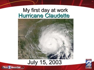
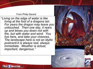
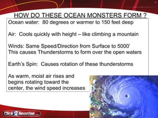
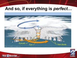
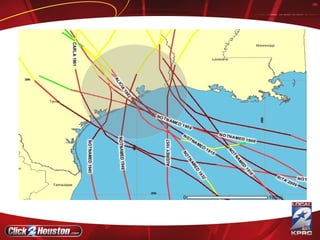
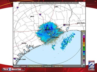
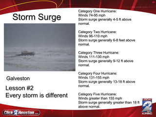
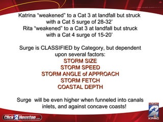
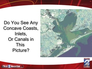
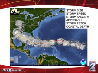
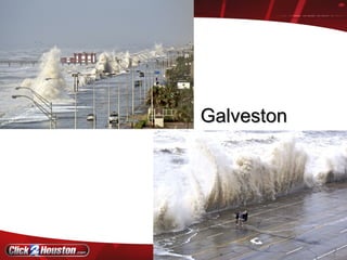
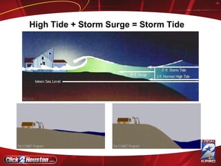
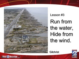
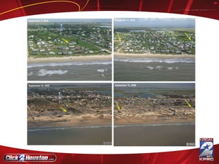
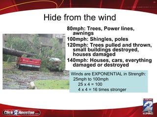
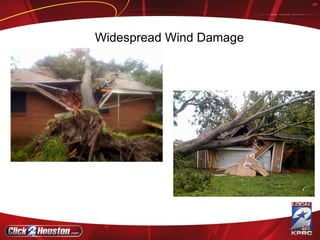
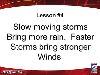
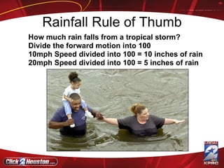
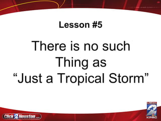
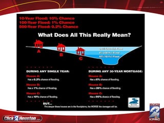
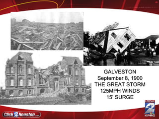
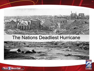
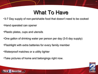
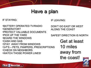
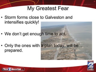
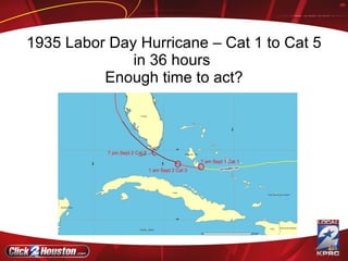
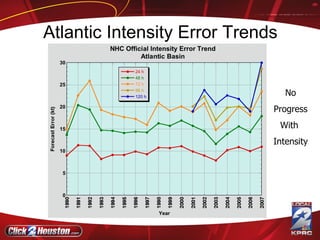
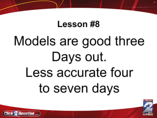
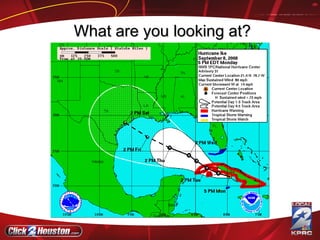
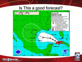
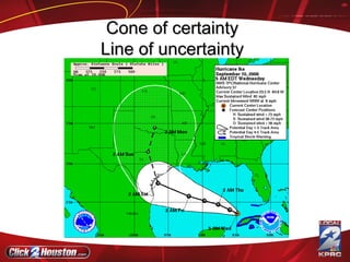
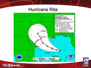
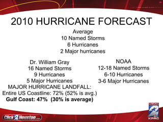
Lessons Learned Anthony Yanez Morning Meteorologist
Hurricane Claudette   July 15, 2003  My first day at work
“ Living on the edge of water is like living at the foot of a dragons lair.  For years the dragon may leave you untouched.  Then one day, it rears up and blows you down not with fire, but with water and wind.  You live here, and take your chances.  The landscape here is not an idyllic postcard-it is always real, always immediate.  Weather is actual, important, dangerous.”  From Philip Gerard
Ocean water:  80 degrees or warmer to 150 feet deep  Air:  Cools quickly with height – like climbing a mountain Winds: Same Speed/Direction from Surface to 5000’  This causes Thunderstorms to form over the open waters Earth’s Spin:  Causes rotation of these thunderstorms As warm, moist air rises and  begins rotating toward the center, the wind speed increases HOW DO THESE OCEAN MONSTERS FORM ?
Angular Momentum! Just as a Tetherball speeds up the closer it gets to the pole, winds speed up the closer they get to the center of the storm—this is called Conservation of Angular Momentum!
And so, if everything is  perfect …
Lesson #1 Hurricanes Will hit Southeast Texas
 
 
Category One Hurricane:  Winds 74-95 mph  Storm surge generally 4-5 ft above normal. Category Two Hurricane:  Winds 96-110 mph  Storm surge generally 6-8 feet above normal.  Category Three Hurricane:  Winds 111-130 mph  Storm surge generally 9-12 ft above normal. Category Four Hurricane:  Winds 131-155 mph  Storm surge generally 13-18 ft above normal.  Category Five Hurricane:  Winds greater than 155 mph  Storm surge generally greater than 18 ft above normal.   Storm Surge Galveston Lesson #2 Every storm is different
Katrina “weakened” to a Cat 3 at landfall but struck  with a Cat 5 surge of 28-32’  Rita “weakened” to a Cat 3 at landfall but struck with a Cat 4 surge of 15-20’  Surge is CLASSIFIED by Category, but dependent upon several factors: STORM SIZE STORM SPEED STORM ANGLE of APPROACH STORM FETCH COASTAL DEPTH Surge  will be even higher when funneled into canals inlets, and against concave coasts!
Do You See Any Concave Coasts, Inlets, Or Canals in This  Picture?
STORM SIZE STORM SPEED STORM ANGLE of APPROACH STORM FETCH COASTAL DEPTH
Galveston
High Tide + Storm Surge = Storm Tide
Run from the water,  Hide from the wind. Gilchrist Lesson #3
 
Hide from the wind 80mph: Trees, Power lines, awnings 100mph: Shingles, poles 120mph: Trees pulled and thrown, small buildings destroyed, houses damaged 140mph: Houses, cars, everything damaged or destroyed Winds are EXPONENTIAL in Strength: 25mph to 100mph 25 x 4 = 100 4 x 4 = 16 times stronger
How Fast are the winds?
 
SUSTAINED WINDS OF 110 MPH AT LANDFALL WERE POSSIBLE MORE LIKELY, 90-100MPH STRONGEST WINDS EAST OF THE EYE; HOWEVER, MOST INTENSE (duration) WINDS WERE TO THE SOUTH OF THE EYE WINDS LASTED AN AVERAGE OF 9 HOURS   Ike Winds
No Tornadoes….Bad Engineering But some Venturi Effect
Widespread Wind Damage
Lesson #4 Slow moving storms Bring more rain.  Faster Storms bring stronger Winds.
Rainfall Rule of Thumb How much rain falls from a tropical storm?  Divide the forward motion into 100  10mph Speed divided into 100 = 10 inches of rain 20mph Speed divided into 100 = 5 inches of rain
Lesson #5 There is no such Thing as “ Just a Tropical Storm”
 
 
Lesson #6 You only know What you know.
GALVESTON September 8, 1900 THE GREAT STORM 125MPH WINDS 15’ SURGE
The Nations Deadliest Hurricane
8,000 – 12,000 DEAD
3-7 Day supply of non-perishable food that doesn’t need to be cooked Hand operated can opener Plastic plates, cups and utensils One gallon of drinking water per person per day (3-5 day supply)  Flashlight with extra batteries for every family member Waterproof matches or a utility lighter Take pictures of home and belongings right now.  What To Have
IF STAYING: BATTERY OPERATED TV/RADIO GENERATOR? PROTECT VALUABLE DOCUMENTS PICK UP THE YARD BOARD THE WINDOWS CASH AND GAS  STAY  AWAY FROM WINDOWS 3-P’S – PETS, PAMPERS, PRESCRIPTIONS CHECK ON NEIGHBORS WATCH THOSE POWER LINES! Get at least 10 miles away from the coast! IF LEAVING: DON’T GO EAST OR WEST ALONG THE COAST SAFEST DIRECTION IS NORTH Have a plan
Lesson #7 Expect the unexpected
My Greatest Fear Storm forms close to Galveston and intensifies quickly! We don’t get enough time to act. Only the ones with a plan today, will be prepared.
1935 Labor Day Hurricane – Cat 1 to Cat 5 in 36 hours  Enough time to act? 7 am Sept 1 Cat 1 O O 1 am Sept 2 Cat 3 O 7 pm Sept 2 Cat 5
No Progress With  Intensity Atlantic Intensity Error Trends
DEAN FELIX HUMBERTO
Lesson #8 Models are good three Days out. Less accurate four to seven days
What are you looking at?
Is This a good forecast?
Cone of certainty Line of uncertainty
Hurricane Rita
 
Widespread panic  because  of Katrina Lesson #9 - 5 out of 6 times you evacuate Nothing will happen.
2010 HURRICANE FORECAST Dr. William Gray 16 Named Storms 9 Hurricanes 5 Major Hurricanes MAJOR HURRICANE LANDFALL: Entire US Coastline: 72% (52% is avg.) Gulf Coast: 47%  (30% is average) NOAA 12-18 Named Storms 6-10 Hurricanes 3-6 Major Hurricanes Average 10 Named Storms 6 Hurricanes 2 Major hurricanes
2011 HURRICANE FORECAST Accuweather 15 Named Storms 8 Hurricanes 4 Major Hurricanes Impact Weather (Houston firm works with oil companies) 14 Tropical Storms 8 Hurricanes 4 Major Hurricanes Weather Research Center 10 Named Storms 6 Hurricanes 5 Strikes on the U.S. Texas 70% (51% avg.)
Make that plan today, don’t wait.
Lesson #10 Storms Love Irony
Kemah
Names for Atlantic Storms 2011 HURRICANE NAMES Arlene Bret Cindy Don Emily Franklin Gert Harvey Irene Jose Katia Lee Maria Nate Ophelia Philippe Rina Sean Tammy Vince Whitney
Hurricanes

Hurricanes

  • 1.
  • 2.
    Lessons Learned AnthonyYanez Morning Meteorologist
  • 3.
    Hurricane Claudette July 15, 2003 My first day at work
  • 4.
    “ Living onthe edge of water is like living at the foot of a dragons lair. For years the dragon may leave you untouched. Then one day, it rears up and blows you down not with fire, but with water and wind. You live here, and take your chances. The landscape here is not an idyllic postcard-it is always real, always immediate. Weather is actual, important, dangerous.” From Philip Gerard
  • 5.
    Ocean water: 80 degrees or warmer to 150 feet deep Air: Cools quickly with height – like climbing a mountain Winds: Same Speed/Direction from Surface to 5000’ This causes Thunderstorms to form over the open waters Earth’s Spin: Causes rotation of these thunderstorms As warm, moist air rises and begins rotating toward the center, the wind speed increases HOW DO THESE OCEAN MONSTERS FORM ?
  • 6.
    Angular Momentum! Justas a Tetherball speeds up the closer it gets to the pole, winds speed up the closer they get to the center of the storm—this is called Conservation of Angular Momentum!
  • 7.
    And so, ifeverything is perfect …
  • 8.
    Lesson #1 HurricanesWill hit Southeast Texas
  • 9.
  • 10.
  • 11.
    Category One Hurricane: Winds 74-95 mph Storm surge generally 4-5 ft above normal. Category Two Hurricane: Winds 96-110 mph Storm surge generally 6-8 feet above normal. Category Three Hurricane: Winds 111-130 mph Storm surge generally 9-12 ft above normal. Category Four Hurricane: Winds 131-155 mph Storm surge generally 13-18 ft above normal. Category Five Hurricane: Winds greater than 155 mph Storm surge generally greater than 18 ft above normal. Storm Surge Galveston Lesson #2 Every storm is different
  • 12.
    Katrina “weakened” toa Cat 3 at landfall but struck with a Cat 5 surge of 28-32’ Rita “weakened” to a Cat 3 at landfall but struck with a Cat 4 surge of 15-20’ Surge is CLASSIFIED by Category, but dependent upon several factors: STORM SIZE STORM SPEED STORM ANGLE of APPROACH STORM FETCH COASTAL DEPTH Surge will be even higher when funneled into canals inlets, and against concave coasts!
  • 13.
    Do You SeeAny Concave Coasts, Inlets, Or Canals in This Picture?
  • 14.
    STORM SIZE STORMSPEED STORM ANGLE of APPROACH STORM FETCH COASTAL DEPTH
  • 15.
  • 16.
    High Tide +Storm Surge = Storm Tide
  • 17.
    Run from thewater, Hide from the wind. Gilchrist Lesson #3
  • 18.
  • 19.
    Hide from thewind 80mph: Trees, Power lines, awnings 100mph: Shingles, poles 120mph: Trees pulled and thrown, small buildings destroyed, houses damaged 140mph: Houses, cars, everything damaged or destroyed Winds are EXPONENTIAL in Strength: 25mph to 100mph 25 x 4 = 100 4 x 4 = 16 times stronger
  • 20.
    How Fast arethe winds?
  • 21.
  • 22.
    SUSTAINED WINDS OF110 MPH AT LANDFALL WERE POSSIBLE MORE LIKELY, 90-100MPH STRONGEST WINDS EAST OF THE EYE; HOWEVER, MOST INTENSE (duration) WINDS WERE TO THE SOUTH OF THE EYE WINDS LASTED AN AVERAGE OF 9 HOURS Ike Winds
  • 23.
    No Tornadoes….Bad EngineeringBut some Venturi Effect
  • 24.
  • 25.
    Lesson #4 Slowmoving storms Bring more rain. Faster Storms bring stronger Winds.
  • 26.
    Rainfall Rule ofThumb How much rain falls from a tropical storm? Divide the forward motion into 100 10mph Speed divided into 100 = 10 inches of rain 20mph Speed divided into 100 = 5 inches of rain
  • 27.
    Lesson #5 Thereis no such Thing as “ Just a Tropical Storm”
  • 28.
  • 29.
  • 30.
    Lesson #6 Youonly know What you know.
  • 31.
    GALVESTON September 8,1900 THE GREAT STORM 125MPH WINDS 15’ SURGE
  • 32.
  • 33.
  • 34.
    3-7 Day supplyof non-perishable food that doesn’t need to be cooked Hand operated can opener Plastic plates, cups and utensils One gallon of drinking water per person per day (3-5 day supply) Flashlight with extra batteries for every family member Waterproof matches or a utility lighter Take pictures of home and belongings right now. What To Have
  • 35.
    IF STAYING: BATTERYOPERATED TV/RADIO GENERATOR? PROTECT VALUABLE DOCUMENTS PICK UP THE YARD BOARD THE WINDOWS CASH AND GAS STAY AWAY FROM WINDOWS 3-P’S – PETS, PAMPERS, PRESCRIPTIONS CHECK ON NEIGHBORS WATCH THOSE POWER LINES! Get at least 10 miles away from the coast! IF LEAVING: DON’T GO EAST OR WEST ALONG THE COAST SAFEST DIRECTION IS NORTH Have a plan
  • 36.
    Lesson #7 Expectthe unexpected
  • 37.
    My Greatest FearStorm forms close to Galveston and intensifies quickly! We don’t get enough time to act. Only the ones with a plan today, will be prepared.
  • 38.
    1935 Labor DayHurricane – Cat 1 to Cat 5 in 36 hours Enough time to act? 7 am Sept 1 Cat 1 O O 1 am Sept 2 Cat 3 O 7 pm Sept 2 Cat 5
  • 39.
    No Progress With Intensity Atlantic Intensity Error Trends
  • 40.
  • 41.
    Lesson #8 Modelsare good three Days out. Less accurate four to seven days
  • 42.
    What are youlooking at?
  • 43.
    Is This agood forecast?
  • 44.
    Cone of certaintyLine of uncertainty
  • 45.
  • 46.
  • 47.
    Widespread panic because of Katrina Lesson #9 - 5 out of 6 times you evacuate Nothing will happen.
  • 48.
    2010 HURRICANE FORECASTDr. William Gray 16 Named Storms 9 Hurricanes 5 Major Hurricanes MAJOR HURRICANE LANDFALL: Entire US Coastline: 72% (52% is avg.) Gulf Coast: 47% (30% is average) NOAA 12-18 Named Storms 6-10 Hurricanes 3-6 Major Hurricanes Average 10 Named Storms 6 Hurricanes 2 Major hurricanes
  • 49.
    2011 HURRICANE FORECASTAccuweather 15 Named Storms 8 Hurricanes 4 Major Hurricanes Impact Weather (Houston firm works with oil companies) 14 Tropical Storms 8 Hurricanes 4 Major Hurricanes Weather Research Center 10 Named Storms 6 Hurricanes 5 Strikes on the U.S. Texas 70% (51% avg.)
  • 50.
    Make that plantoday, don’t wait.
  • 51.
  • 52.
  • 53.
    Names for AtlanticStorms 2011 HURRICANE NAMES Arlene Bret Cindy Don Emily Franklin Gert Harvey Irene Jose Katia Lee Maria Nate Ophelia Philippe Rina Sean Tammy Vince Whitney

Editor's Notes

  • #6 Season is from June 1 to Nov 30, Coriolis Effect, Conservation of Angular momentum
  • #7 This is like an iceskater also!
  • #20 Impaled palm from Hurricane Andrew
  • #35 Maps come in handy because you may be forced to take a route you are not used to! Public shelters do not allow animals—plan with friends if possible. Tie to your pets collar what your plan is in case you get separated. Don’t forget leashes and litter boxes!
  • #36 Maps come in handy because you may be forced to take a route you are not used to! Public shelters do not allow animals—plan with friends if possible. Tie to your pets collar what your plan is in case you get separated. Don’t forget leashes and litter boxes!