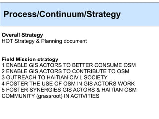
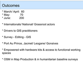
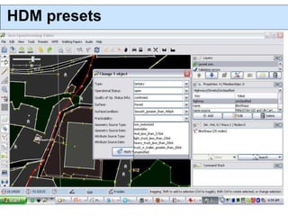
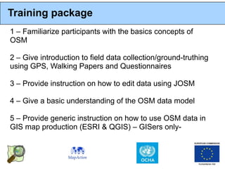
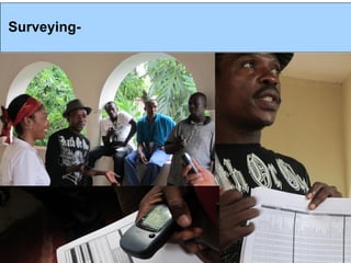
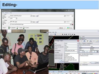
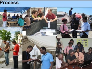
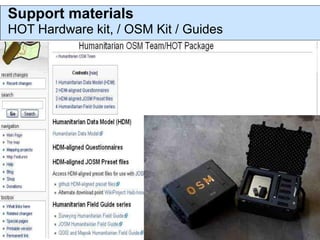
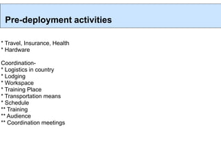
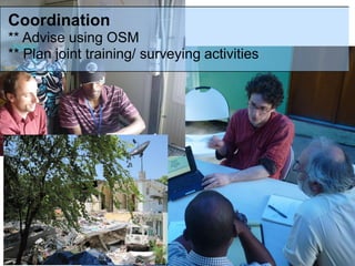
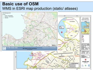
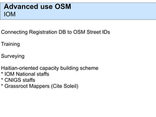
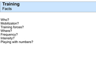
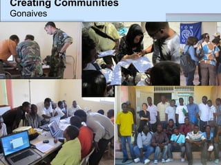
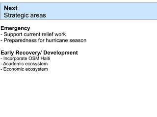
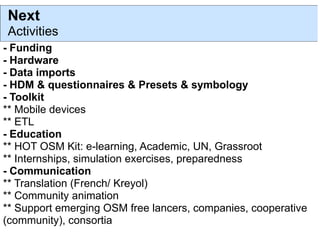
Grounding the OSM Project
The Humanitarian OSM Team in Haiti
Intro

Preparedness
Disaster response
* remote work
* field work: 7 weeks 3 missions (March - June 2010)
Early Recovery/ Development (MapKibera)


Powered by MapAction/ECHO and World Bank ($)
OSM & HOT
Supported in the field by UN (IOM), CNIGS, FOCS


Growth and sustainability of OSM project in Haiti (OSM Haiti)
Challenges

Time

Context :
* post disaster
* LDC & poverty vs VGI
* Accessibility to territories, internet & power
* Institutional fragmentation
* Under resourced ($, staffs & discontinuous GIS capacities
* Lack of IM/GIS culture
* Lack of high quality (geom & semantic) open data

-> Mis-use & under-use of scarce resources
Process/Continuum/Strategy

Overall Strategy
HOT Strategy & Planning document


Field Mission strategy
1 ENABLE GIS ACTORS TO BETTER CONSUME OSM
2 ENABLE GIS ACTORS TO CONTRIBUTE TO OSM
3 OUTREACH TO HAITIAN CIVIL SOCIETY
4 FOSTER THE USE OF OSM IN GIS ACTORS WORK
5 FOSTER SYNERGIES GIS ACTORS & HAITIAN OSM
COMMUNITY (grassroot) IN ACTIVITIES
Outcomes
* March/ April: 60
* May:         70
* June:        200

* Internationals/ National/ Grassroot actors

* Drivers to GIS practitioners

* Survey - Editing - GIS

* Port Au Prince, Jacmel/ Leogane/ Gonaives

* Empowered with hardware kits & access to functional working
spaces

* OSM in Map Production & in humanitarian baseline surveys
ENABLERS
OSM
HOT
Humanitarian Data Model
Semantic interoperability
HDM Questionnaires.
HDM presets
Training package
1 – Familiarize participants with the basics concepts of
OSM

2 – Give introduction to field data collection/ground-truthing
using GPS, Walking Papers and Questionnaires

3 – Provide instruction on how to edit data using JOSM

4 – Give a basic understanding of the OSM data model

5 – Provide generic instruction on how to use OSM data in
GIS map production (ESRI & QGIS) – GISers only-
Surveying-
Collecting-
Editing-
Process
Support materials
HOT Hardware kit, / OSM Kit / Guides
Deploy
Pre-deployment activities

* Travel, Insurance, Health
* Hardware

Coordination-
* Logistics in country
* Lodging
* Workspace
* Training Place
* Transportation means
* Schedule
** Training
** Audience
** Coordination meetings
Coordination
** Advise using OSM
** Plan joint training/ surveying activities
Basic use of OSM
WMS in ESRI map production (static/ atlases)
Advanced use OSM
 IOM

Connecting Registration DB to OSM Street IDs

Training

Surveying

Haitian-oriented capacity building scheme
* IOM National staffs
* CNIGS staffs
* Grassroot Mappers (Cite Soleil)
Training
 Facts

Who?
Mobilizaton?
Training forces?
Where?
Frequency?
Intensity?
Playing with numbers?
Creating Communities
Gonaives
Next
 Strategic areas

Emergency
- Support current relief work
- Preparedness for hurricane season

Early Recovery/ Development
- Incorporate OSM Haiti
- Academic ecosystem
- Economic ecosystem
Next
Activities
- Funding
- Hardware
- Data imports
- HDM & questionnaires & Presets & symbology
- Toolkit
** Mobile devices
** ETL
- Education
** HOT OSM Kit: e-learning, Academic, UN, Grassroot
** Internships, simulation exercises, preparedness
- Communication
** Translation (French/ Kreyol)
** Community animation
** Support emerging OSM free lancers, companies, cooperative
(community), consortia
OSM: emerging disruptive paradigm in
 crisis mapping?
Timely accessibility to high quality open data
Access to all open pre/ post quake data
Mapping force
Training force
Incubator for new economic model
Empowerment

Glocal continuum (development - emergency - development)
allowing collective open cumulative GI knowledge building
process
HOT post humanitarian track gathering


Talk-ht@openstreetmap.org
hot@openstreetmap.org


http://wiki.openstreetmap.org/wiki/Humanitarian_OSM_
Team
http://hot.openstreetmap.org/weblog/
http://twitter.com/hotosm
http://www.facebook.com/pages/Humanitarian-
OpenStreetMap-Team-HOT/131576396870787?v=wall

nicolas.chavent@gmail.com
SHAME!
Guens opened the streets in Haiti, EU closed its
borders

Work of the Humanitarian OpenStreetMap Team (HOT) in Haiti March-June 2010

  • 1.
    Grounding the OSMProject The Humanitarian OSM Team in Haiti
  • 2.
    Intro Preparedness Disaster response * remotework * field work: 7 weeks 3 missions (March - June 2010) Early Recovery/ Development (MapKibera) Powered by MapAction/ECHO and World Bank ($) OSM & HOT Supported in the field by UN (IOM), CNIGS, FOCS Growth and sustainability of OSM project in Haiti (OSM Haiti)
  • 3.
    Challenges Time Context : * postdisaster * LDC & poverty vs VGI * Accessibility to territories, internet & power * Institutional fragmentation * Under resourced ($, staffs & discontinuous GIS capacities * Lack of IM/GIS culture * Lack of high quality (geom & semantic) open data -> Mis-use & under-use of scarce resources
  • 4.
    Process/Continuum/Strategy Overall Strategy HOT Strategy& Planning document Field Mission strategy 1 ENABLE GIS ACTORS TO BETTER CONSUME OSM 2 ENABLE GIS ACTORS TO CONTRIBUTE TO OSM 3 OUTREACH TO HAITIAN CIVIL SOCIETY 4 FOSTER THE USE OF OSM IN GIS ACTORS WORK 5 FOSTER SYNERGIES GIS ACTORS & HAITIAN OSM COMMUNITY (grassroot) IN ACTIVITIES
  • 5.
    Outcomes * March/ April:60 * May: 70 * June: 200 * Internationals/ National/ Grassroot actors * Drivers to GIS practitioners * Survey - Editing - GIS * Port Au Prince, Jacmel/ Leogane/ Gonaives * Empowered with hardware kits & access to functional working spaces * OSM in Map Production & in humanitarian baseline surveys
  • 6.
  • 7.
  • 8.
  • 9.
  • 10.
  • 11.
  • 12.
    Training package 1 –Familiarize participants with the basics concepts of OSM 2 – Give introduction to field data collection/ground-truthing using GPS, Walking Papers and Questionnaires 3 – Provide instruction on how to edit data using JOSM 4 – Give a basic understanding of the OSM data model 5 – Provide generic instruction on how to use OSM data in GIS map production (ESRI & QGIS) – GISers only-
  • 13.
  • 14.
  • 15.
  • 16.
  • 17.
    Support materials HOT Hardwarekit, / OSM Kit / Guides
  • 18.
  • 19.
    Pre-deployment activities * Travel,Insurance, Health * Hardware Coordination- * Logistics in country * Lodging * Workspace * Training Place * Transportation means * Schedule ** Training ** Audience ** Coordination meetings
  • 20.
    Coordination ** Advise usingOSM ** Plan joint training/ surveying activities
  • 21.
    Basic use ofOSM WMS in ESRI map production (static/ atlases)
  • 22.
    Advanced use OSM IOM Connecting Registration DB to OSM Street IDs Training Surveying Haitian-oriented capacity building scheme * IOM National staffs * CNIGS staffs * Grassroot Mappers (Cite Soleil)
  • 23.
  • 24.
  • 25.
    Next Strategic areas Emergency -Support current relief work - Preparedness for hurricane season Early Recovery/ Development - Incorporate OSM Haiti - Academic ecosystem - Economic ecosystem
  • 26.
    Next Activities - Funding - Hardware -Data imports - HDM & questionnaires & Presets & symbology - Toolkit ** Mobile devices ** ETL - Education ** HOT OSM Kit: e-learning, Academic, UN, Grassroot ** Internships, simulation exercises, preparedness - Communication ** Translation (French/ Kreyol) ** Community animation ** Support emerging OSM free lancers, companies, cooperative (community), consortia
  • 27.
    OSM: emerging disruptiveparadigm in crisis mapping? Timely accessibility to high quality open data Access to all open pre/ post quake data Mapping force Training force Incubator for new economic model Empowerment Glocal continuum (development - emergency - development) allowing collective open cumulative GI knowledge building process
  • 28.
    HOT post humanitariantrack gathering Talk-ht@openstreetmap.org hot@openstreetmap.org http://wiki.openstreetmap.org/wiki/Humanitarian_OSM_ Team http://hot.openstreetmap.org/weblog/ http://twitter.com/hotosm http://www.facebook.com/pages/Humanitarian- OpenStreetMap-Team-HOT/131576396870787?v=wall nicolas.chavent@gmail.com
  • 29.
    SHAME! Guens opened thestreets in Haiti, EU closed its borders