
Recommended
More Related Content
What's hot
What's hot (20)
Similar to Hydrology 9.pdf
Similar to Hydrology 9.pdf (20)
Recently uploaded
Recently uploaded (20)
Hydrology 9.pdf
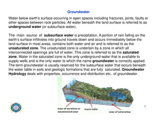
- 1. Groundwater Water below earth’s surface occurring in open spaces including fractures, joints, faults or other spaces between rock particles. All water beneath the land surface is referred to as underground water (or subsurface water). The main source of subsurface water is precipitation. A portion of rain falling on the earth’s surface infiltrates into ground travels down and occurs immediately below the land surface in most areas, contains both water and air and is referred to as the unsaturated zone. The unsaturated zone is underlain by a zone in which all interconnected openings are full of water. This zone is referred to as the saturated zone. Water in the saturated zone is the only underground water that is available to supply wells and is the only water to which the name groundwater is correctly applied. supply wells and is the only water to which the name groundwater is correctly applied. The term groundwater is usually reserved for the subsurface water that occurs beneath the water table in soils and geologic formations that are fully saturated. Groundwater Hydrology deals with properties, occurrence and distribution etc.. of groundwater. 1
- 2. Underground water vertical distribution Underground water occurs in two different zones. One zone, which occurs immediately below the land surface in most areas, contains both water and air and is referred to as the unsaturated zone or zone of aeration. The unsaturated zone is almost underlain by a zone in which all interconnected openings are full of water. This zone is referred to as the saturated zone or Zone of saturation. 2 Underground water distribution
- 3. Recharge of the saturated zone occurs by percolation of water from the land surface through the unsaturated zone. The unsaturated zone is, therefore, of great importance to ground-water hydrology. This zone may be divided usefully into three parts : 1) the soil zone, 2) the intermediate zone, and 3)the upper part of the capillary fringe. 1)The moisture soil zone extends from the land surface to a maximum depth of a meter or two and is the zone that supports plant growth. The porosity and permeability of this zone tend to be higher than those of the underlying material . 2) The soil zone is underlain by the intermediate zone, which differs in thickness from place to place depending on the thickness of the soil zone and the depth to the capillary fringe. fringe. 3) the capillary fringe, the subzone between the unsaturated and saturated zones. The capillary fringe results from the attraction between water and rocks. As a result of this attraction, water clings as a film on the surface of rock particles and rises in small- diameter pores against the pull of gravity. The water table is the level in the saturated zone at which the hydraulic pressure is equal to atmospheric pressure and is represented by the water level in unused wells 3
- 4. Types of the geological formations: Groundwater storage capacity and its movement depend upon the type of porous medium (geological formation). There are four types of geological formations as follows: (1) Aquifers: A water bearing geologic formation or stratum capable of transmitting water through its pores at a rate sufficient for economic extraction by wells. unconsolidated gravels, sands, alluvium, etc. (2) Aquitard: A geologic formation of rather impervious nature, which transmits water at a slow rate compared to an aquifer (insufficient for pumping from wells).Examples are sandy clay is an example and clay lenses interceded with sand. are sandy clay is an example and clay lenses interceded with sand. (3)Aquiclude: A geologic formation, which can absorb water but relatively impermeable that does not yield appreciable quantities of water to wells though it may contain large amount of water due to its high porosity. Examples are clays, shales, etc. (4) Aquifuge: A relatively impermeable formation neither containing nor transmitting water (neither porous nor permeable). Examples are basalts, granites, etc. 4
- 5. Types of Aquifers: 1) Unconfined Aquifer: It is an aquifer with water table as its upper boundary and underlain by an impervious bed underneath. Because the aquifer is not under pressure the water level inn a well drilled in it is the same as the water table outside the well. well drilled into this aquifer is called a water table well. 2) Confined Aquifer: A confined aquifer, also known as an artesian aquifer, is overlain and underlain by an impervious bed. groundwater is confined under pressure greater than atmospheric pressure. The water level rises in the well drilled in this type to its initial level at the recharge source called the piezometric surface. It is an imaginary surface coinciding with the hydrostatic pressure level of the water in the aquifer. If the piezometric surface is above the ground level at the location of the the aquifer. If the piezometric surface is above the ground level at the location of the well, the well is called ‘flowing artesian well’ since the water flows out of the well without pumping, and if the piezometric surface is below the ground level at the well location, the well is called a non-flowing artesian well. 3) Perched Aquifer: A special case of an unconfined aquifer involves perched water bodies. This occurs wherever a groundwater body is separated from the main groundwater by a relatively impermeable stratum of small areal extent and by the zone of aeration above the main body of groundwater. Clay lenses in sedimentary deposits often have shallow perched water bodies overlying them. Wells tapping these sources yield only temporarily or small quantities of water. 5
- 6. Types of Aquifers: 6 Types of aquifers and location of wells
- 7. Groundwater movement: Groundwater flows slowly through the voids between grains or the cracks in solid rock. DARCY’S LAW The velocity of flow is given by Darcy’s law (1856), which states that ‘the velocity of flow laminar flow The velocity of flow is given by Darcy’s law (1856), which states that ‘the velocity of flow in a porous medium is proportional to the hydraulic gradient: V=Ki=K∆h/l V: velocity, K, hydraulic conductivity, and is a measure of the permeability of the material through which the water is flowing i: Hydraulic gradiant (i= ∆h/l) Groundwater generally flows in the direction of the hydraulic gradient and slope of the water table. Q= AV Q=Ak ∆h/l Q: Discharge, A: Area 7
- 8. Wells: 1. Normal wells 2. Artesian wells Radial Flow at a well: Removal of groundwater faster than it can flow back lowers the water table near the well. The GWT becomes a radially symmetrical funnel shape called the cone of depression. The drawdown of the GWT during flow from a well varies with distance 8