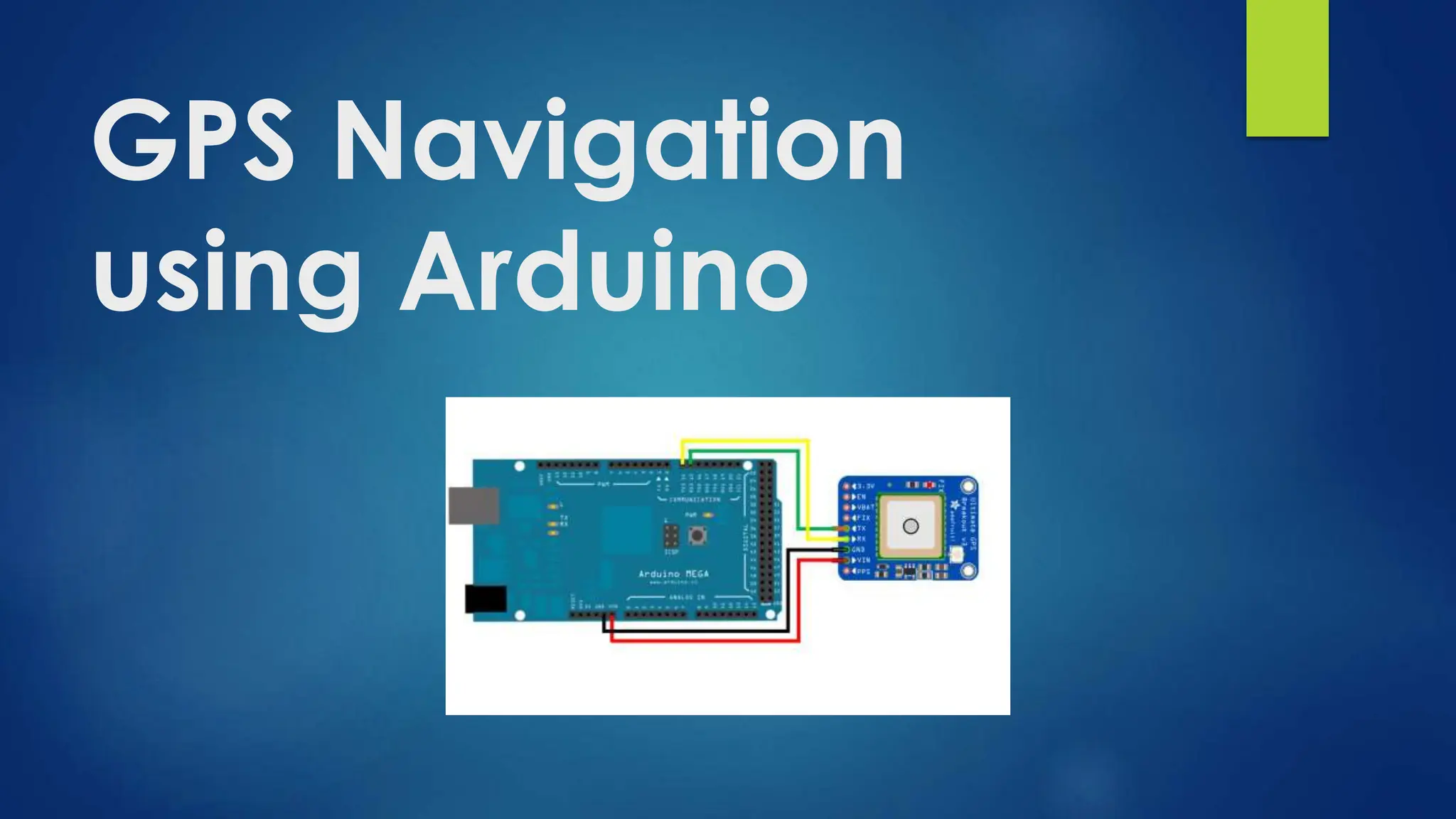
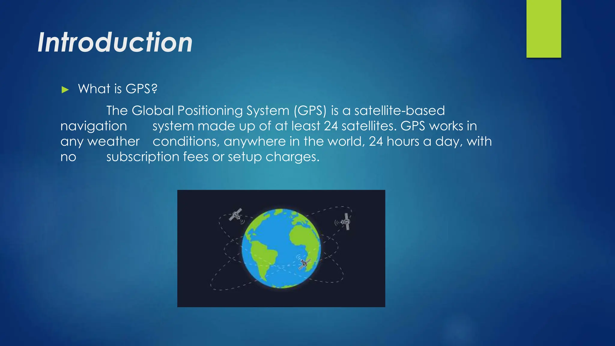
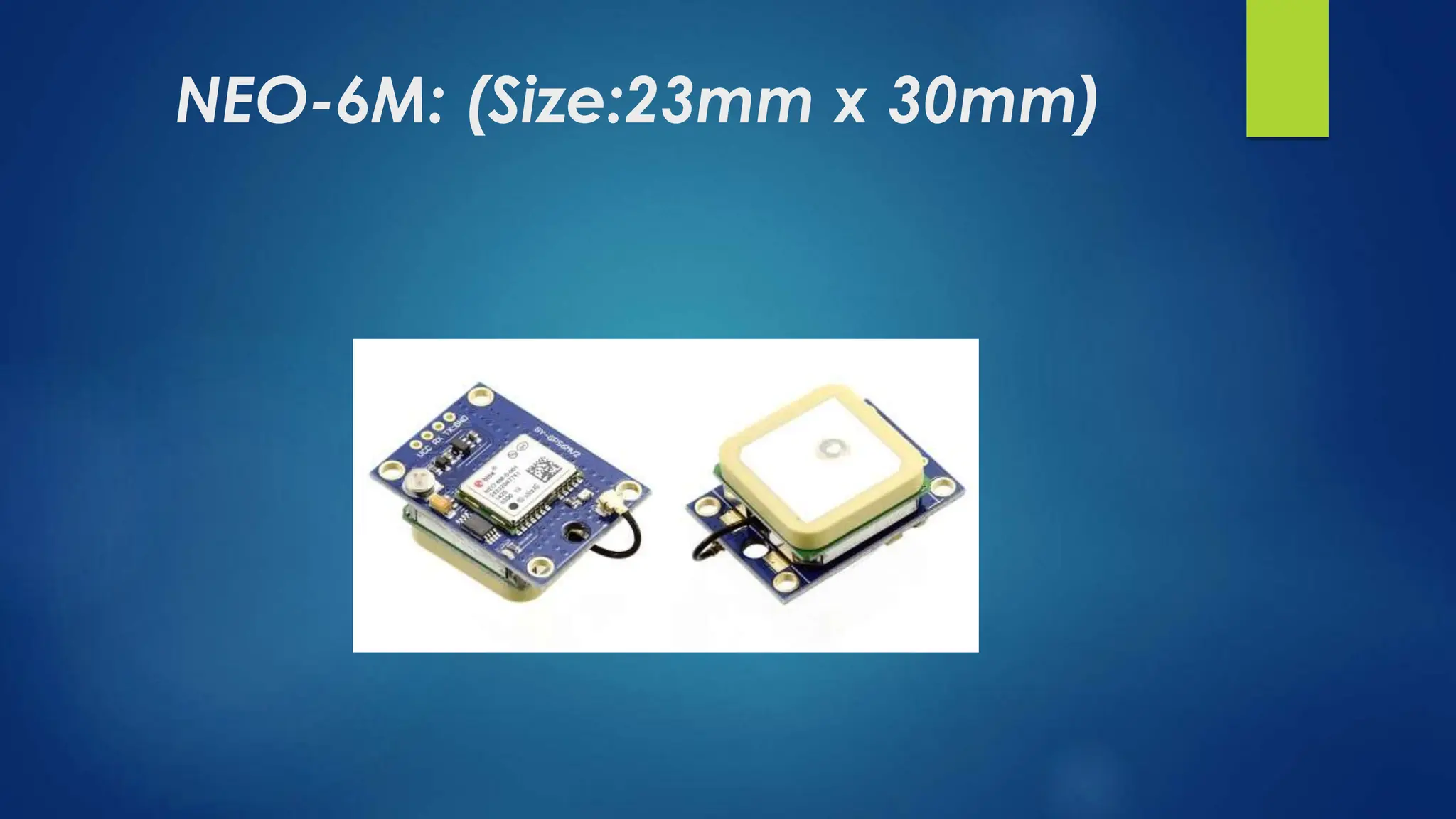
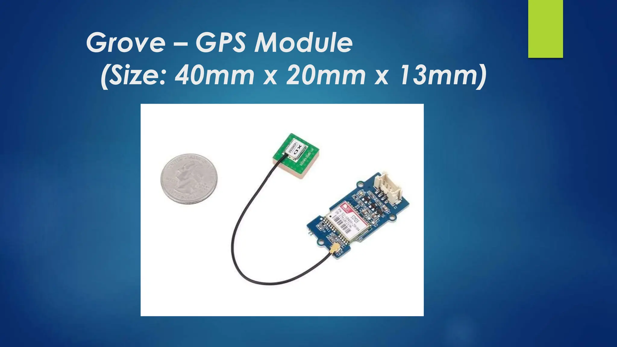
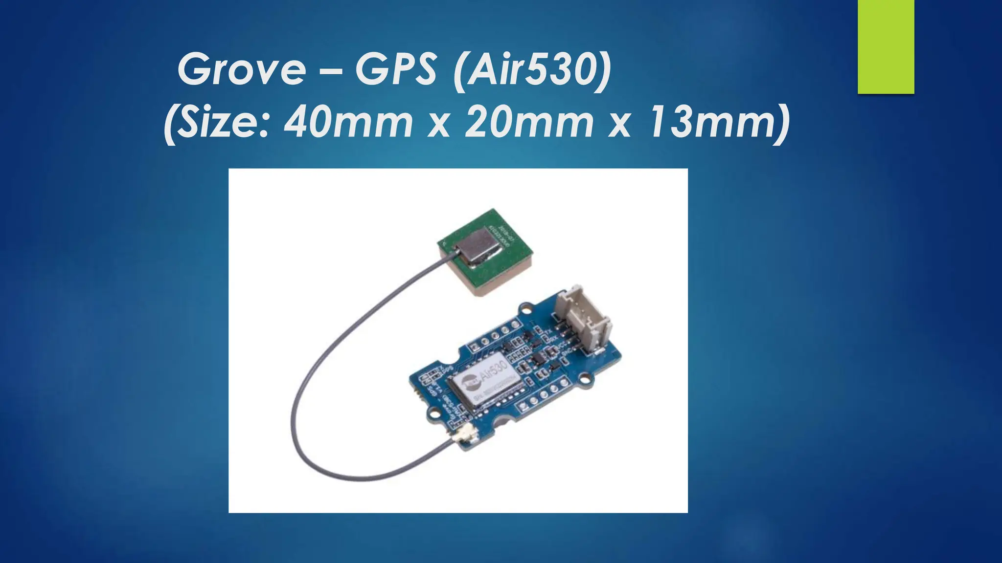
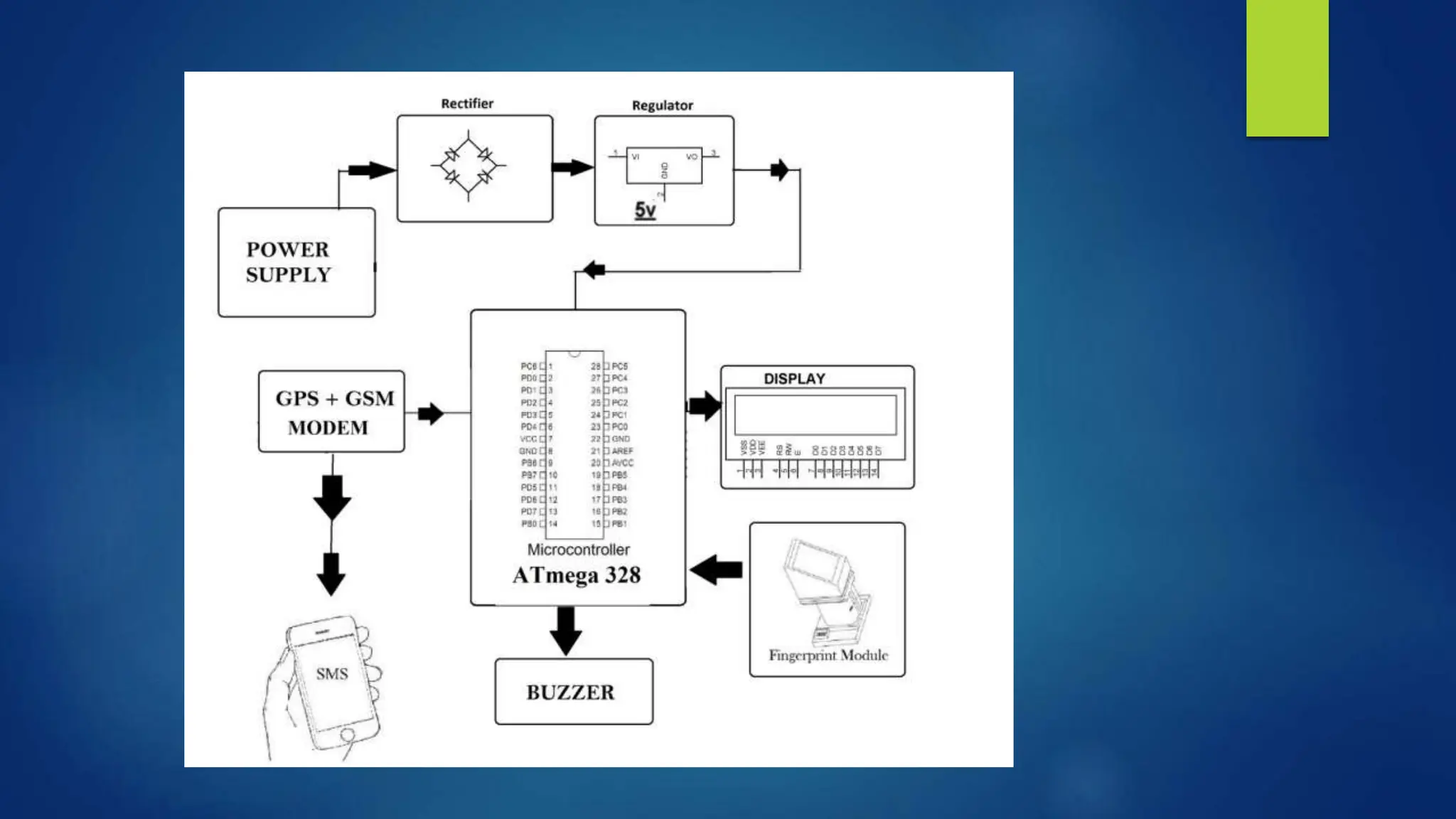
GPS Navigation
using Arduino
Introduction
► What is GPS?
The Global Positioning System (GPS) is a satellite-based
navigation system made up of at least 24 satellites. GPS works in
any weather conditions, anywhere in the world, 24 hours a day, with
no subscription fees or setup charges.
How does a GPS work?
► GPS satellites circle the Earth twice a day in a precise orbit. Each
satellite transmits a unique signal and orbital parameters that allow
GPS devices to decode and compute the precise location of the
satellite. GPS receivers use this information and trilateration to
calculate a user's exact location. Essentially, the GPS receiver
measures the distance to each satellite by the amount of time it takes
to receive a transmitted signal. With distance measurements from a
few more satellites, the receiver can determine a user's position and
display it.
► To calculate your 2-D position (latitude and longitude) and track
movement, a GPS receiver must be locked on to the signal of at least
3 satellites. With 4 or more satellites in view, the receiver can
determine your 3-D position (latitude, longitude and altitude).
Generally, a GPS receiver will track 8 or more satellites, but that
depends on the time of day and where you are on the earth.
Continued….
► Once your position has been determined, the GPS unit can
calculate other information, such as:
⮚ Speed
⮚ Bearing
⮚ Track
⮚ Trip distance
⮚ Distance to destination
What is Navigation?
► Navigation refers to the method of determining aspects
such as position, speed, and direction during travel. In
the pre-modern era, direction and position were
determined using an altazimuth, a compass, and a map;
these are now considered primitive forms of navigation.
As a result of modern developments in science and
technology, exact positions and speeds are determined
using equipment such as artificial satellites, global
navigation satellite system (GNSS), inertial navigation
systems (INS), etc. In the modern sense, navigation is
mechanical devices equipped in ground vehicles, ships,
and aircraft to determine their positions.
What are GPS Modules?
GPS modules contain tiny processors and
antennas that directly receive data sent by
satellites through dedicated RF frequencies.
From there, it'll receive timestamp from
each visible satellites, along with other
pieces of data.
How does it work?
The GPS receiver gets a signal from each GPS satellite. The
satellites transmit the exact time the signals are sent. ... So
given the travel time of the GPS signals from three satellites
and their exact position in the sky, the GPS receiver can
determine your position in three dimensions – east, north
and altitude.
Arduino GPS Modules
There are three Arduino GPS Modules:
► NEO-6M
► Grove – GPS Module
► Grove – GPS (Air530)
NEO-6M: (Size:23mm x 30mm)
NEO-6M
► The NEO-6MV2 is a GPS (Global Positioning System)
module and is used for navigation. The module
simply checks its location on earth and provides output
data which is longitude and latitude of its position.
► The compact architecture, power and memory
options make NEO-6 modules ideal for battery
operated mobile devices with very strict cost and
space constraints. Its Innovative design gives NEO-
6MV2 excellent navigation performance even in the
most challenging environments.
Grove – GPS Module
(Size: 40mm x 20mm x 13mm)
Grove – GPS Module
► The Grove - GPS module is a cost-efficient and field-
programmable gadget armed with a SIM28 module
and serial communication configuration.
► Similar to other Grove series sensors, it plugs directly into
the Grove UART interface development board and
provides a precise, sensitive, low power GPS module
for position recognition anywhere in the world. It
features 22 tracking / 66 acquisition channels GPS
receiver.
Grove – GPS (Air530)
(Size: 40mm x 20mm x 13mm)
Grove – GPS (Air530)
► It’s a high-performance, highly integrated multi-mode
satellite positioning and navigation module. It supports
GPS / Beidou / Glonass / Galileo / QZSS / SBAS, which
makes it suitable for GNSS positioning applications
such as car navigation, smart wear, and drone.
If your GPS isn’t working well in urban areas or outdoors
under only one or a few satellite modules, you should
definitely check out this GPS module. Meanwhile, this
module is capable of receiving more than 6 satellites
at the same time and is able to work excellently even
if there’s a very bad signal.
A GPS signal contains 3 different
types of information:
► PseudoRandom code is an I.D. code that identifies which
satellite is transmitting information. You can see which
satellites you are getting signals from on your device's
satellite page.
► Ephemeris data is needed to determine a satellite's position
and gives important information about the health of a
satellite, current date and time.
► Almanac data tells the GPS receiver where each GPS
satellite should be at any time throughout the day and
shows the orbital information for that satellite and every
other satellite in the system.
GSM Modem
► A GSM modem is a specialized type of modem which
accepts a SIM card, and operates over a subscription to
a mobile operator, just like a mobile phone. From the
mobile operator perspective, a GSM modem looks just like
a mobile phone.
► When a GSM modem is connected to a computer, this
allows the computer to use the GSM modem to
communicate over the mobile network. While these GSM
modems are most frequently used to provide mobile
internet connectivity, many of them can also be used for
sending and receiving SMS and MMS messages.
GPS Modem
► GPS Receiver receives the information in string format,
transmitted by Satellites and uses this information to
calculate different parameters between it and satellites.
With information from satellites, a GPS receiver can fix its
location on the ground from the known position of the
satellites.
► The GPS modem has antenna which receives the satellite
signals and transfers them to the modem. The modem in
turn converts the data into useful information and sends the
output in serial RS232 logic level format. The information
about latitude etc. is sent continuously and accompanied
by an identifier string.
Introduction to MAX232
► MAX232 is an integrated circuit (embedded in a single chip)
designed by Maxim Integrated Products and act as a Voltage Logic
Converter i.e. it is used to convert TTL Logic level (Microcontrollers'
COM Port) into TIA/EIA-232-F level (Laptop Serial Port RS-232) and
vice versa.
► It is used for the communication between Microcontroller and PC or
laptop.
Applications of GPS Navigation
► Aviation
► Marine
► Farming
► Surveying
► Military
References
http://arduiniana.org/libraries/tinygps/#:~:text=A%20Compact%20Ard
uino%20GPS%2FNMEA,accompany%20similar%20bodies%20of%20code
https://www.instructables.com/Arduino-GPS-Map-Navigation-
System/?amp_page=true
https://www.open-electronics.org/guest_projects/arduino-gps-map-
navigation-system/amp/
References cont
https://create.arduino.cc/projecthub/ruchir1674/how-to-interface-
gps-module-neo-6m-with-arduino-8f90ad
https://www.slideshare.net/mobile/UVSoftsTechnologies/gps-based-
tracking-system
https://www.arduino.cc/en/Guide/ArduinoGSMShield

GPS NAVIGATION Using Arduino Presentation

  • 1.
  • 2.
    Introduction ► What isGPS? The Global Positioning System (GPS) is a satellite-based navigation system made up of at least 24 satellites. GPS works in any weather conditions, anywhere in the world, 24 hours a day, with no subscription fees or setup charges.
  • 3.
    How does aGPS work? ► GPS satellites circle the Earth twice a day in a precise orbit. Each satellite transmits a unique signal and orbital parameters that allow GPS devices to decode and compute the precise location of the satellite. GPS receivers use this information and trilateration to calculate a user's exact location. Essentially, the GPS receiver measures the distance to each satellite by the amount of time it takes to receive a transmitted signal. With distance measurements from a few more satellites, the receiver can determine a user's position and display it. ► To calculate your 2-D position (latitude and longitude) and track movement, a GPS receiver must be locked on to the signal of at least 3 satellites. With 4 or more satellites in view, the receiver can determine your 3-D position (latitude, longitude and altitude). Generally, a GPS receiver will track 8 or more satellites, but that depends on the time of day and where you are on the earth.
  • 4.
    Continued…. ► Once yourposition has been determined, the GPS unit can calculate other information, such as: ⮚ Speed ⮚ Bearing ⮚ Track ⮚ Trip distance ⮚ Distance to destination
  • 5.
    What is Navigation? ►Navigation refers to the method of determining aspects such as position, speed, and direction during travel. In the pre-modern era, direction and position were determined using an altazimuth, a compass, and a map; these are now considered primitive forms of navigation. As a result of modern developments in science and technology, exact positions and speeds are determined using equipment such as artificial satellites, global navigation satellite system (GNSS), inertial navigation systems (INS), etc. In the modern sense, navigation is mechanical devices equipped in ground vehicles, ships, and aircraft to determine their positions.
  • 6.
    What are GPSModules? GPS modules contain tiny processors and antennas that directly receive data sent by satellites through dedicated RF frequencies. From there, it'll receive timestamp from each visible satellites, along with other pieces of data.
  • 7.
    How does itwork? The GPS receiver gets a signal from each GPS satellite. The satellites transmit the exact time the signals are sent. ... So given the travel time of the GPS signals from three satellites and their exact position in the sky, the GPS receiver can determine your position in three dimensions – east, north and altitude.
  • 8.
    Arduino GPS Modules Thereare three Arduino GPS Modules: ► NEO-6M ► Grove – GPS Module ► Grove – GPS (Air530)
  • 9.
  • 10.
    NEO-6M ► The NEO-6MV2is a GPS (Global Positioning System) module and is used for navigation. The module simply checks its location on earth and provides output data which is longitude and latitude of its position. ► The compact architecture, power and memory options make NEO-6 modules ideal for battery operated mobile devices with very strict cost and space constraints. Its Innovative design gives NEO- 6MV2 excellent navigation performance even in the most challenging environments.
  • 11.
    Grove – GPSModule (Size: 40mm x 20mm x 13mm)
  • 12.
    Grove – GPSModule ► The Grove - GPS module is a cost-efficient and field- programmable gadget armed with a SIM28 module and serial communication configuration. ► Similar to other Grove series sensors, it plugs directly into the Grove UART interface development board and provides a precise, sensitive, low power GPS module for position recognition anywhere in the world. It features 22 tracking / 66 acquisition channels GPS receiver.
  • 13.
    Grove – GPS(Air530) (Size: 40mm x 20mm x 13mm)
  • 14.
    Grove – GPS(Air530) ► It’s a high-performance, highly integrated multi-mode satellite positioning and navigation module. It supports GPS / Beidou / Glonass / Galileo / QZSS / SBAS, which makes it suitable for GNSS positioning applications such as car navigation, smart wear, and drone. If your GPS isn’t working well in urban areas or outdoors under only one or a few satellite modules, you should definitely check out this GPS module. Meanwhile, this module is capable of receiving more than 6 satellites at the same time and is able to work excellently even if there’s a very bad signal.
  • 15.
    A GPS signalcontains 3 different types of information: ► PseudoRandom code is an I.D. code that identifies which satellite is transmitting information. You can see which satellites you are getting signals from on your device's satellite page. ► Ephemeris data is needed to determine a satellite's position and gives important information about the health of a satellite, current date and time. ► Almanac data tells the GPS receiver where each GPS satellite should be at any time throughout the day and shows the orbital information for that satellite and every other satellite in the system.
  • 16.
    GSM Modem ► AGSM modem is a specialized type of modem which accepts a SIM card, and operates over a subscription to a mobile operator, just like a mobile phone. From the mobile operator perspective, a GSM modem looks just like a mobile phone. ► When a GSM modem is connected to a computer, this allows the computer to use the GSM modem to communicate over the mobile network. While these GSM modems are most frequently used to provide mobile internet connectivity, many of them can also be used for sending and receiving SMS and MMS messages.
  • 17.
    GPS Modem ► GPSReceiver receives the information in string format, transmitted by Satellites and uses this information to calculate different parameters between it and satellites. With information from satellites, a GPS receiver can fix its location on the ground from the known position of the satellites. ► The GPS modem has antenna which receives the satellite signals and transfers them to the modem. The modem in turn converts the data into useful information and sends the output in serial RS232 logic level format. The information about latitude etc. is sent continuously and accompanied by an identifier string.
  • 18.
    Introduction to MAX232 ►MAX232 is an integrated circuit (embedded in a single chip) designed by Maxim Integrated Products and act as a Voltage Logic Converter i.e. it is used to convert TTL Logic level (Microcontrollers' COM Port) into TIA/EIA-232-F level (Laptop Serial Port RS-232) and vice versa. ► It is used for the communication between Microcontroller and PC or laptop.
  • 20.
    Applications of GPSNavigation ► Aviation ► Marine ► Farming ► Surveying ► Military
  • 21.
  • 22.