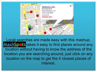
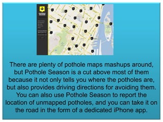
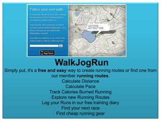
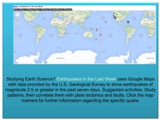
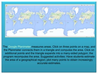
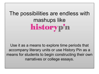
Google Maps &
Mapping
Mashups
According to wikipedia,
A mashup, in web development, is a web page,
or web application, that uses content from more
than one source to create a single new service
displayed in a single graphical interface. In
other words, you
mash two different things
Mashing together a web
application or web page with
Google Maps makes for
some very cool applications!
helps you visualize Instagram on a
map. You can see where your friends are posting
pictures, visualize anyone’s Instagram photos on
a map or search for real-time photos posted at
any location.
Local searches are made easy with this mashup.
Mashspots makes it easy to find places around any
location without having to know the address of the
location you are searching around, just click on any
location on the map to get the 4 closest places of
interest.
There are plenty of pothole maps mashups around,
but Pothole Season is a cut above most of them
because it not only tells you where the potholes are,
but also provides driving directions for avoiding them.
You can also use Pothole Season to report the
location of unmapped potholes, and you can take it on
the road in the form of a dedicated iPhone app.
WalkJogRun
Simply put, it's a free and easy way to create running routes or find one from
our member running routes.
Calculate Distance
Calculate Pace
Track Calories Burned Running
Explore new Running Routes
Log your Runs in our free training diary
Find your next race
Find cheap running gear
Where does a
mapmash fit
in with
education?
Studying Earth Science? Earthquakes in the Last Week uses Google Maps
with data provided by the U.S. Geological Survey to show earthquakes of
magnitude 2.5 or greater in the past seven days. Suggested activities: Study
patterns, then correlate them with plate tectonics and faults. Click the map
markers for further information regarding the specific quake.
The Google Planimeter measures areas. Click on three points on a map, and
the Planimeter connects them in a triangle and computes the area. Click on
additional points and the triangle expands into a many-sided polygon; the
program recomputes the area. Suggested activities: Have students estimate
the area of a geographical region; plot many points to obtain increasingly
accurate estimates.
The possibilities are endless with
mashups like

Use it as a means to explore time periods that
accompany literary units or use History Pin as a
means for students to begin constructing their own
narratives or college essays.
The group presentation on Google Maps and
Mapping Mashups focused on the following four
applications?

1. Geocaching
2. Antenna Search
3. GPS Fitness
4.

Google maps intro

  • 1.
  • 2.
    According to wikipedia, Amashup, in web development, is a web page, or web application, that uses content from more than one source to create a single new service displayed in a single graphical interface. In other words, you mash two different things
  • 3.
    Mashing together aweb application or web page with Google Maps makes for some very cool applications!
  • 4.
    helps you visualizeInstagram on a map. You can see where your friends are posting pictures, visualize anyone’s Instagram photos on a map or search for real-time photos posted at any location.
  • 5.
    Local searches aremade easy with this mashup. Mashspots makes it easy to find places around any location without having to know the address of the location you are searching around, just click on any location on the map to get the 4 closest places of interest.
  • 6.
    There are plentyof pothole maps mashups around, but Pothole Season is a cut above most of them because it not only tells you where the potholes are, but also provides driving directions for avoiding them. You can also use Pothole Season to report the location of unmapped potholes, and you can take it on the road in the form of a dedicated iPhone app.
  • 7.
    WalkJogRun Simply put, it'sa free and easy way to create running routes or find one from our member running routes. Calculate Distance Calculate Pace Track Calories Burned Running Explore new Running Routes Log your Runs in our free training diary Find your next race Find cheap running gear
  • 8.
    Where does a mapmashfit in with education?
  • 9.
    Studying Earth Science?Earthquakes in the Last Week uses Google Maps with data provided by the U.S. Geological Survey to show earthquakes of magnitude 2.5 or greater in the past seven days. Suggested activities: Study patterns, then correlate them with plate tectonics and faults. Click the map markers for further information regarding the specific quake.
  • 10.
    The Google Planimetermeasures areas. Click on three points on a map, and the Planimeter connects them in a triangle and computes the area. Click on additional points and the triangle expands into a many-sided polygon; the program recomputes the area. Suggested activities: Have students estimate the area of a geographical region; plot many points to obtain increasingly accurate estimates.
  • 11.
    The possibilities areendless with mashups like Use it as a means to explore time periods that accompany literary units or use History Pin as a means for students to begin constructing their own narratives or college essays.
  • 12.
    The group presentationon Google Maps and Mapping Mashups focused on the following four applications? 1. Geocaching 2. Antenna Search 3. GPS Fitness 4.