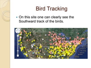
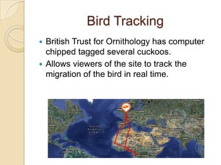
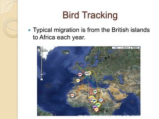
1. Google Maps & Mashups
A Simple Guide to
Mapping within the
Classroom
Created by: Micheale
Brown, Eric Herr, &
Charmaine Scott
2. Maps
Maps are a vital part of society and are
needed on a daily basis.
Students need to be able to utilize maps
within a variety of settings and for diverse
purposes.
When people utilize maps there are times
the information displayed within a map may
need to be diversified according to a
person’s needs or requirements.
3. Mashups
A mashup is when a person takes two or
more applications and combines them to
create a tool they can utilize.
This could include personalizing a map,
creating an assignment where students use
two sets of information and join them
together, locating information and using two
different forms of information on one map.
4. The 3 Types of Mashups
Business mashups-define applications that
combine their own resources, application
and data, with other external Web services.
*Consumer mashups-combines data from
multiple public resources in the browser
and organizes it through a simple browser
user interface.
Data mashups-are opposite from consumer
mashups in that they combine similar media
and information from multiple sources into a
single representation.
5. Consumer Mashups
-The consumer mashup is the most
commonly used mashup.
-These mashups are used in both education
and everyday life.
-Google Maps are widely used for this type of
mashup.
6. RailRadar
Mashup consisting of Google Maps and rail
trains in India.
Rail trains are the most common distance
transportation in the country.
Most all rail operations are owned by the
state called Indian Railways.
Fourth largest system
in the world.
7. RailRadar
This mashup allows its users to view the
entire Indian rail network at once.
8. RailRadar
Green indicates train is on time while red
show a train behind schedule.
9. RailRadar
This is a very useful tool for those who use
the rail system in India.
Clicking on a train will show start times and
expected times of arrival.
A person can also see overall status of the
network- percentage of trains on time/late.
10. RailRadar Educational Uses
This mashup could be utilized within SS if
studying transportation around the world or
even studying the country of India.
Students could create their own
transportation mashups for their daily life
and how they get around to places they
need to go to make it relevant to their life.
11. Bird Tracking
http://www.birdfeeders.com/advice/bird-
watching/hummingbird-migration
This website has an interactive mapping
system allowing Hummingbird migration
tracking.
This website relies on users to input
sighting information.
Those who view the site can scan
information based on species and last date
of sighting.
12. Bird Tracking
On this site one can clearly see the
Southward track of the birds.
13. Bird Tracking
British Trust for Ornithology has computer
chipped tagged several cuckoos.
Allows viewers of the site to track the
migration of the bird in real time.
14. Bird Tracking
Typical migration is from the British islands
to Africa each year.
15. Bird Tracking Educational
Uses
This website could be utilized within a
Science class as they note the migration
patterns of birds and if it is changing.
If the migration patterns are changing the
students can research why is that
happening? Is it because the food supply
has changed and they have to fly farther to
find food?
16. Google My Maps General
Purpose
The website
http://maps.google.com/help/maps/getmaps/plo
t-one.html
This site allows people to create personalized
maps that can be reflective of their personal needs;
such as a walking tour of a city, where libraries are
located, etc…
When a person creates My map with Google they
can save it to utilize for future usage.
This application can be utilized to create a map
that is personalized for a variety of reasons.
17. Google My Maps Average
Usage for this Application
A person can add an icon to represent a
place they want to visit or find important.
It is possible to even get a satellite view of
their map.
A person can save the map and add to it
and even publish it or keep it private
depending on why they created the My Map
with Google.
18. Google My Maps Educational
Uses
This could be utilized within the classroom
setting in regards to researching an area for
important places and then mapping them
out for a class presentation in Social
Studies.
The advantages could include a deeper
understanding of important places in
regards to their place within the map and
how it is diverse from their country.
This mapping is interactive and makes the
information more relevant within the
student’s understanding.
20. Google My Maps Educational
Uses Continued
Another use within the classroom could be
part of a research project that includes
mapping things that a student learned
about and then presenting that information
to the class which could apply to almost any
subject area such as Language Arts.
Students researching William Shakespeare
could create a My Map of William’s life and
where he lived or important places which
affected his life and his writing.
21. The Shakespeare Globe
A website that could be utilized that is
interactive would be:
http://english-
together.net/didapages/Shakespeare
This website allows students to find
interesting facts that could utilized within
their research projects and points that could
be placed within their My Maps about
Shakespeare.
22. Programmable Web/ Mapping
General Purpose
The website:
http://www.programmableweb.com/tag/map
ping
This site allows people to find API’s, codes
mashups, coders to utilize for personal
usage.
This site also allows a person to track news,
trends, and players.
23. Programmable Web/ Mapping
General Purpose Continued
This site also allows people to build and
learn about API’s.
This website allows people connect with
other people who are building and creating
mashups that they prefer to utilize within
their lives.
It also allows people to view mashups that
have been created before.
24. Programmable Web/ Mapping
Average Usage
The average person could utilize this
website as a good resource to learn about
how to create a mashup.
The average person could locate or find the
codes needed for an API to create their
mashup.
The average person can locate a variety of
mapping mashups which include city travel
guides, sundials, towns, basketball
tournaments, etc…
25. Programmable Web/ Mapping
Educational Benefits
There are several educational advantages
to this website because it allows a
teacher/student to explore mapping
mashups in a user friendly way.
This site promotes a variety of mapping
mashups such as: best companies to work
for, finding restaurants, movie stores,, top
medical schools, altitude over the world,
etc…
26. Programmable Web/ Mapping
Educational Benefits
This site also appears user friendly for
people that are not as tech savvy as other
people.
This site gives a wide variety of mashups to
view and utilize as a teacher or a student.
It allows a person an API directory to use
within a mashup they are creating.
27. Programmable Web/ Mapping
Educational Benefits
Continued site to
As a teacher I could utilize this
explore the best companies to work for in
the USA within a SS class.
This particular mashup allows for students
to review and find out information about
companies to work for and where those
companies are located.
28. Programmable Web/ Mapping
Educational Benefits
This website could be useful within a SS
class to explore Altitude and what the
Altitude is from anywhere in the world.
This mashup assists students in connecting
the places on the map with the altitude in
connection to where they live.
The interactive process allows students be
in control of what altitude they are viewing
and exploring.
29. Potential Risks of Google Mashups
Security Risks
- mashups are Web 2.0 and rely on AJAX
which could create issues for end users
which is why there is the AJAX and Mashup
Security.
Social Media & Social Networking
- lots of these sites give access to third
parties.
Passwords and Emails
- mashups may expose these so you must be
sure to open web standards for use
30. Potential Risks of Google
Mashups Continued
Compatibility
- mashups are both applications and
websites and with that being said they may
reach users who use several different
browsers and operating systems. This
may require server-side and client-side
modifications.
-mashups that are designed for one
operating system and browser for a
specific organization are easier to
manage.
31. Google Map Mashups are
Useful Tools
They can be used in a variety of ways:
For the elementary students to create a
tour of the neighborhood by identifying the
school, grocery store, firehouse or park
and having the ability to see the actual
building would be a great tool to use in the
classroom.
In a physical education class by tracking
how many calories a student will burn by
having students plan a walking program
for exercise (ex: school to home).
32. Google Map Mashups are
Useful Tools Continued
Health organizations, nursing students, and
science classes can use them to identify
diseases on the rise, how they are treated,
who is affected by it, and which areas are
most common or likely for the disease to
spread.
Geology classes can identify earthquakes
over the past seven days and study the
patterns then relate them with plate
tectonics, and also both the magnitude of
the earthquake as well as the location.