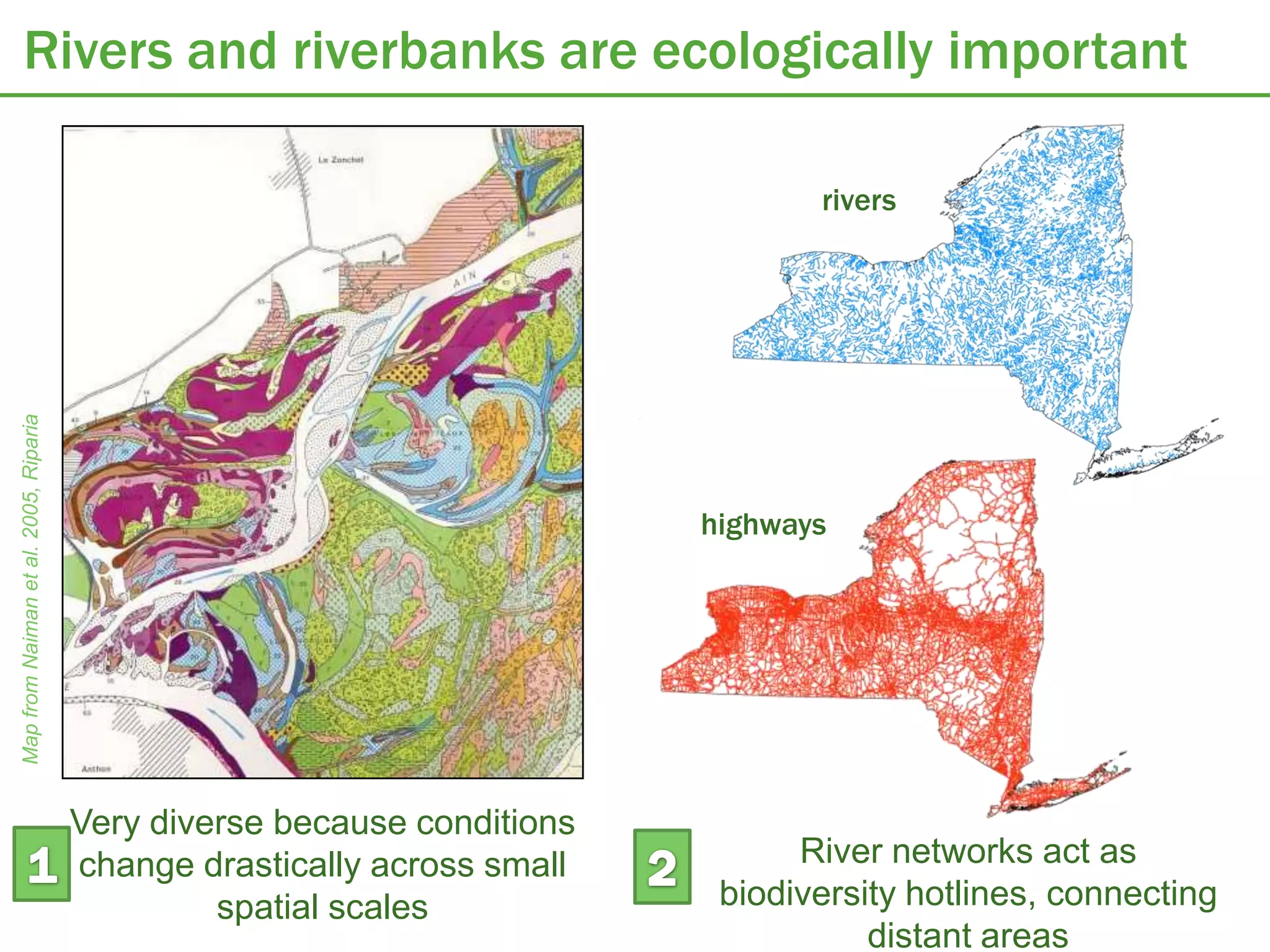
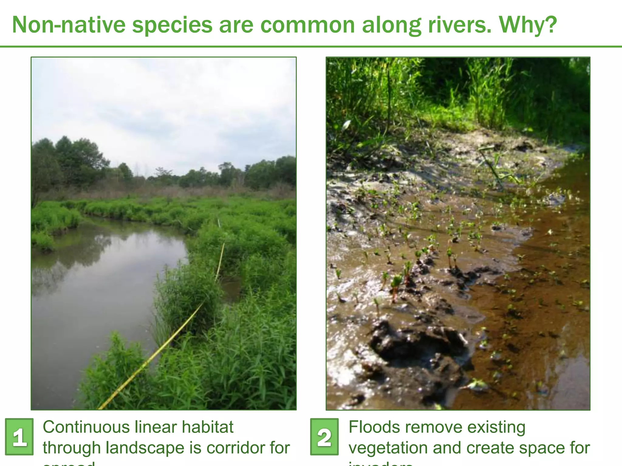
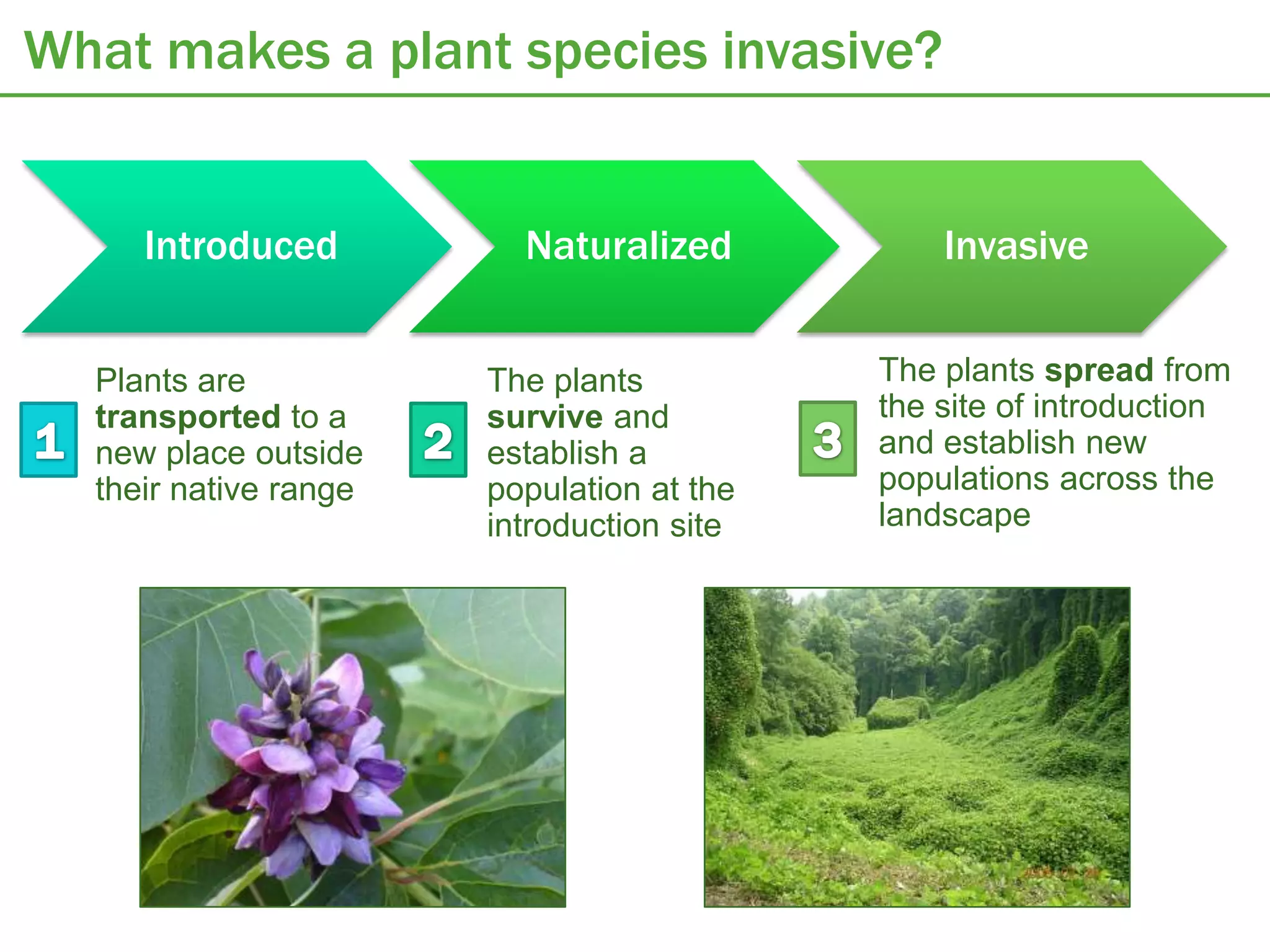
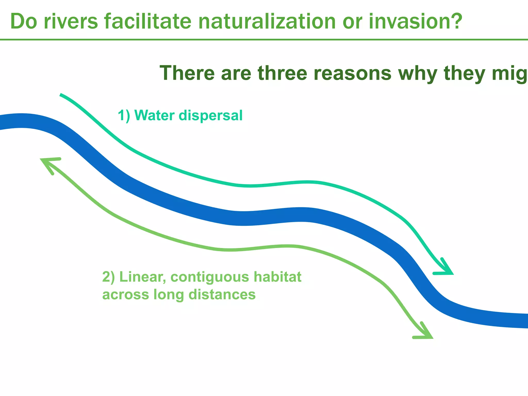
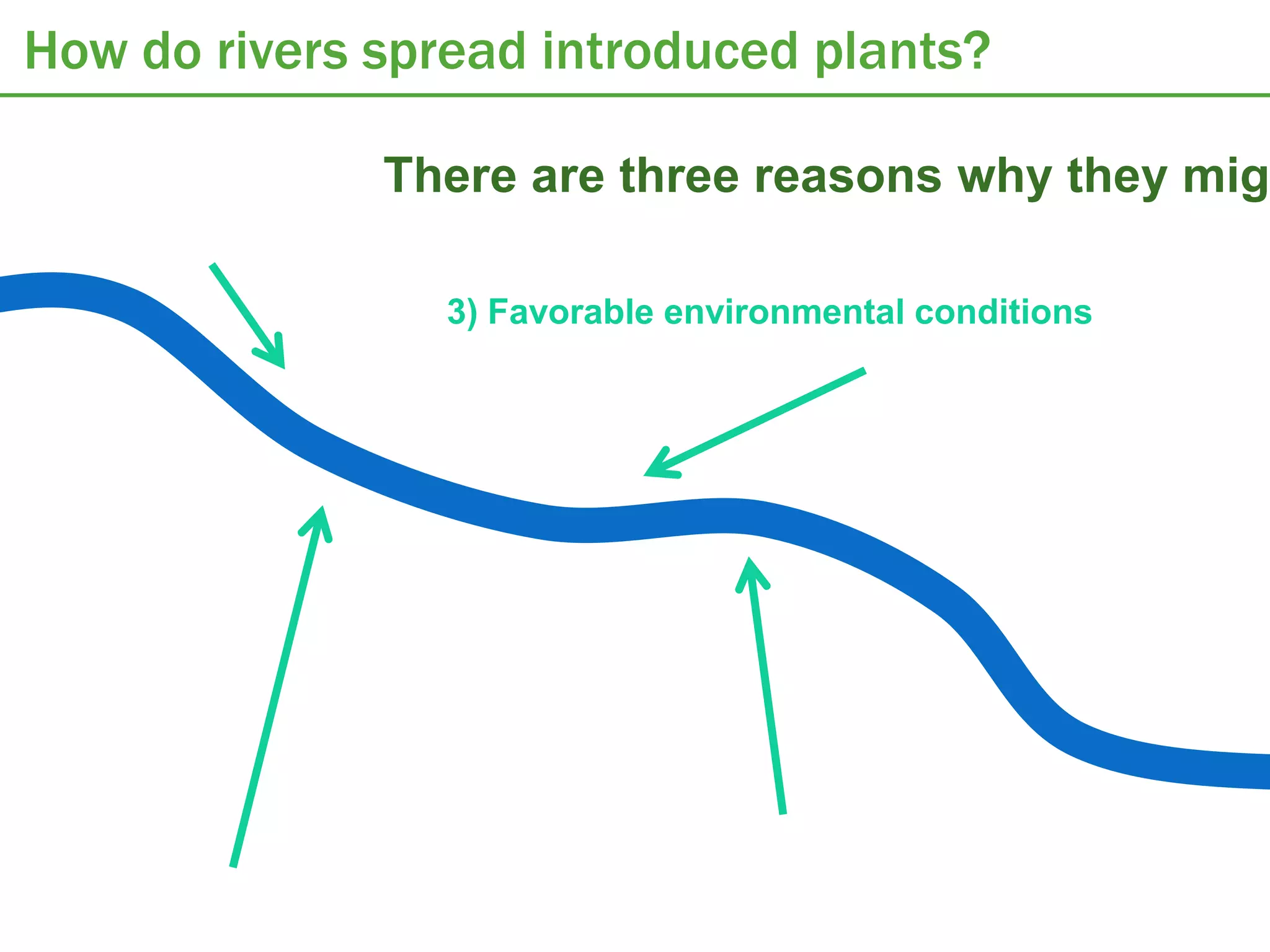
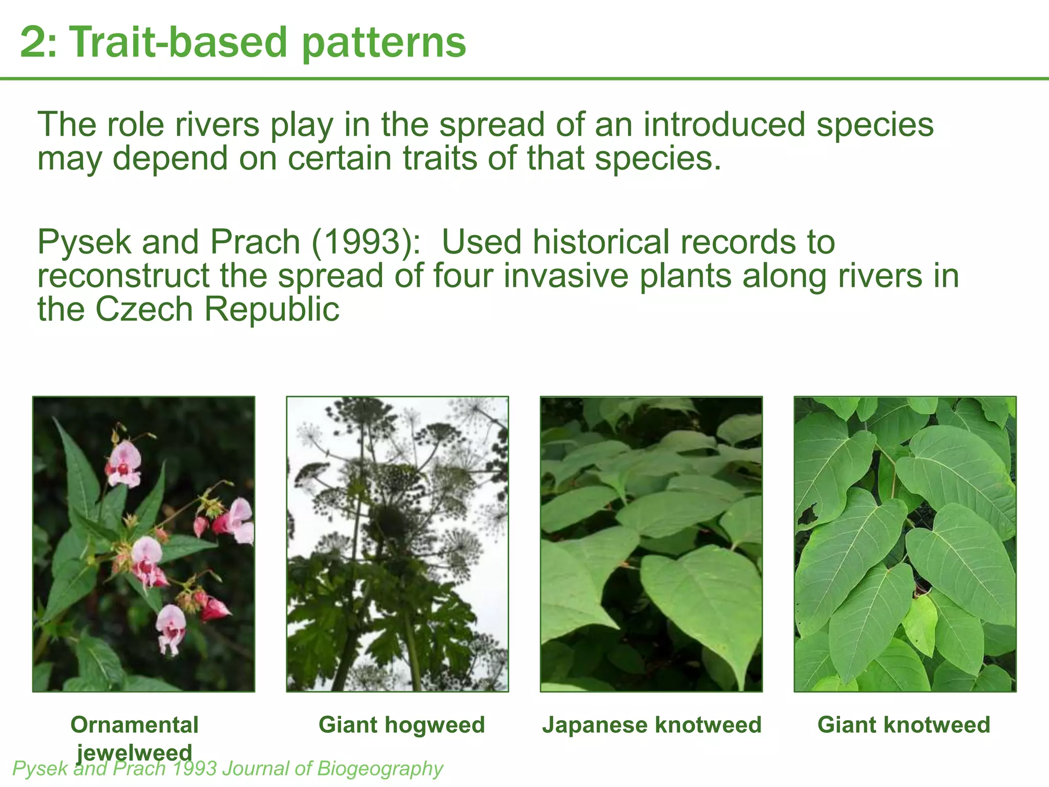
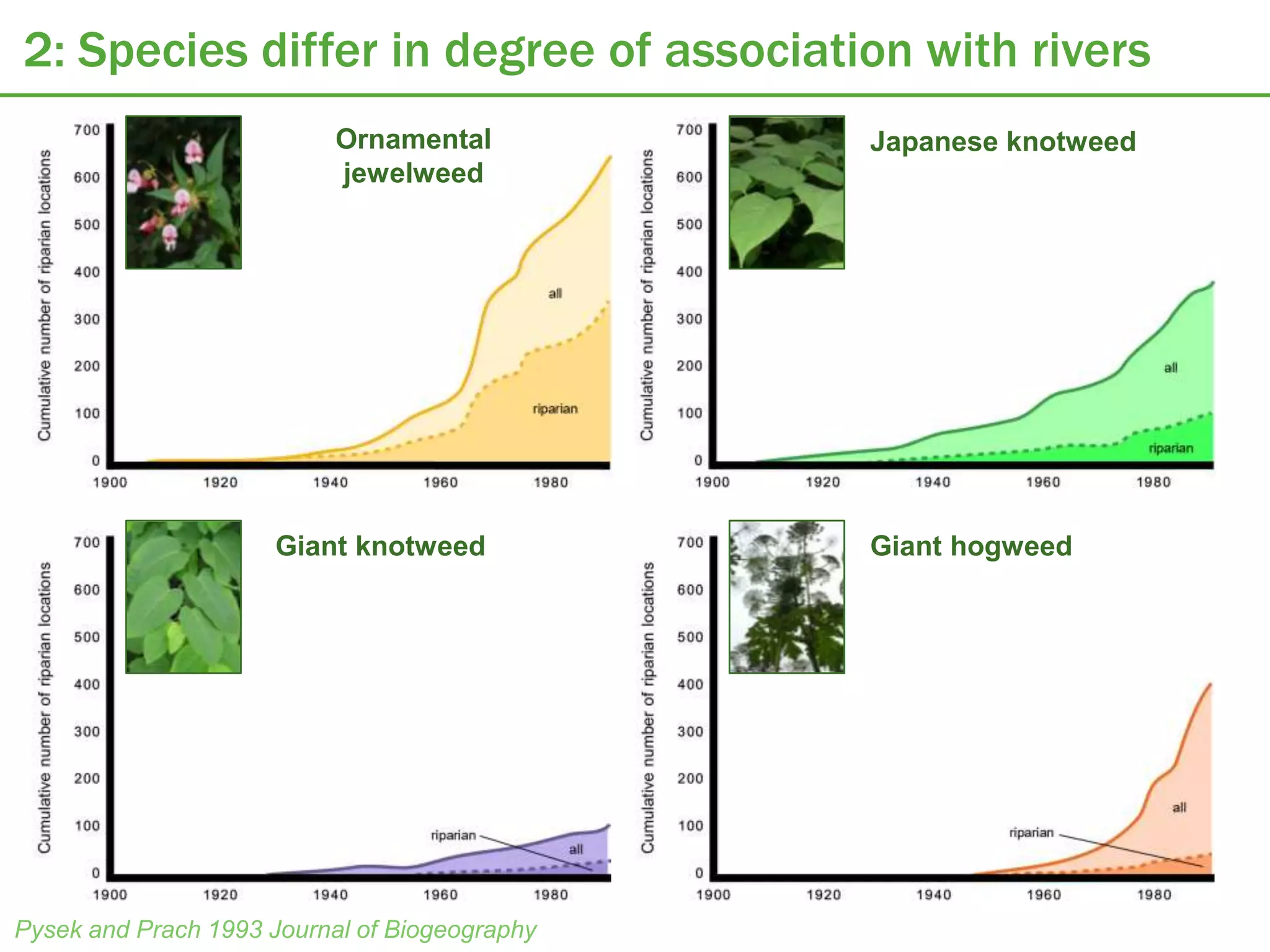
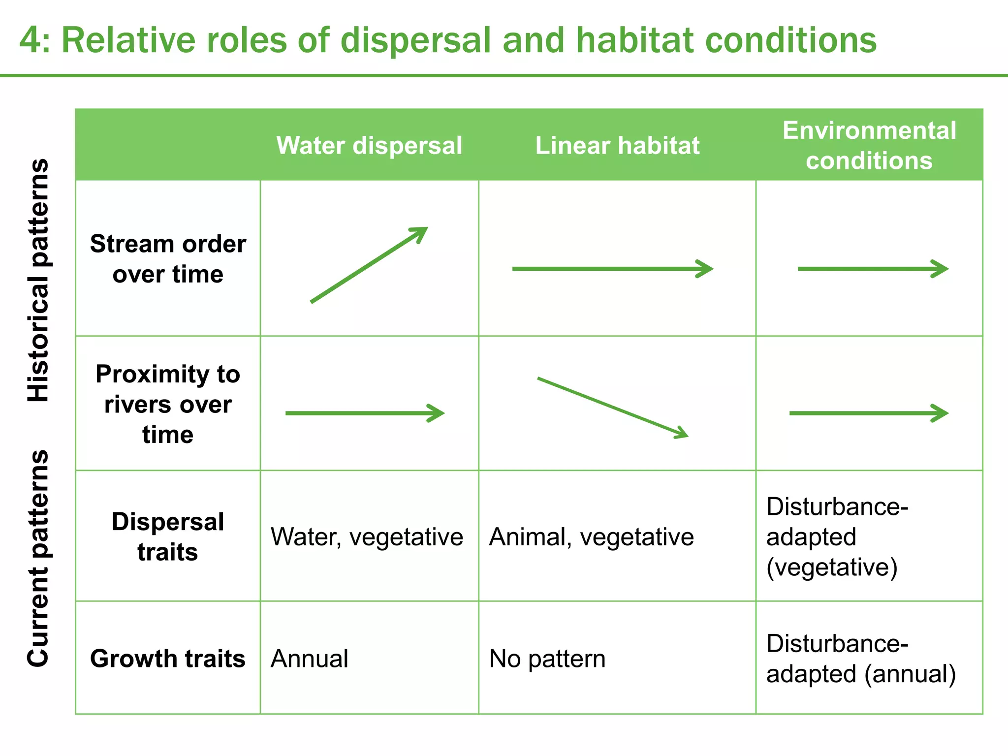
Understanding the spread of introduced plant
   species in river networks: A GIS-based
            landscape approach

             Emily Rollinson
               05/14/12
Rivers and riverbanks are ecologically important

                                                                                rivers
Map from Naiman et al. 2005, Riparia


                                                                         highways


                                       Very diverse because conditions
                                       change drastically across small         River networks act as
                                                spatial scales            biodiversity hotlines, connecting
                                                                                    distant areas
Non-native species are common along rivers. Why?


  Continuous linear habitat           Floods remove existing
  through landscape is corridor for   vegetation and create space for
What makes a plant species invasive?


     Introduced          Naturalized           Invasive


  Plants are           The plants          The plants spread from
  transported to a     survive and         the site of introduction
  new place outside    establish a         and establish new
  their native range   population at the   populations across the
                       introduction site   landscape
Do rivers facilitate naturalization or invasion?

                 There are three reasons why they migh
           1) Water dispersal


         2) Linear, contiguous habitat
         across long distances
How do rivers spread introduced plants?

              There are three reasons why they migh

                 3) Favorable environmental conditions
The GIS-based landscape approach

Many previous studies have directly shown that
rivers facilitate the spread of one or two
introduced species

But: there is no way to know from these case
studies if rivers play a general role in spreading
many introduced species, or if it is species-
specific.

With GIS, databases of introduced species
locations, along with models of river systems,
can be used to look address this question for
many species across a broad spatial scale
Proposal objectives

1. Evaluate the degree to which introduced
   species are currently associated with riparian
   zones.
2. Assess trait-based patterns in the current
   association of groups of introduced species
   with riparian zones.
3. Assess historical evidence for the spread of
   introduced species along river corridors.

4. Use the above patterns to distinguish
   among the effects of water dispersal,
   habitat linearity, and favorable
   environmental conditions in facilitating
   introduced species in riparian zones.
Available invasive species databases

 There are hundreds of
 regional invasive species
 databases that contain
 location data.

 I will use two:

 Invasive Plant Atlas of New
 England (IPANE)

 Early Detection and
 Distribution Mapping
 System (EDDMapS)
EDDMapS

• Early detection and
  distribution mapping
  system
• Presence of invasive   Many species with fewer records

  species in the         650 species      At least 100 records

  continental USA
• Database contains
                         258 species     At least 1000 records
  2261 plant species
• Most records in the    Fewer species with many records
  past decade             50 species         5000 records
IPANE
• Records of invasive
  species
  presence/absence
  in New England
• Collates historical
  herbarium records
  that document
  recorded locations
  of introduced
  species over the
  past century
Available rivers data
• USGS: National
  hydrography
  dataset
   – Digital vector
     dataset for GIS that
     contains water
     features
     (lakes, ponds, river
     s…)
   – Contains
     information on flow
     direction
1: Broad patterns of association with rivers

• If rivers play some role in the success of introduced
  species, then those species should be found near rivers
  more often than would expected if they were distributed
  randomly across the landscape.

• Approach: Compare the distances from rivers for
  introduced species against the distances from rivers for
  random points distributed across the landscape.
   – Use ArcGIS to calculate the distance of each of these points
     from the nearest river in the National Hydrography Dataset
   – Create frequency distributions for the distance from the
     nearest river for all points for each species
   – Produce an overall frequency distribution for introduced
     species
   – Use ArcGIS to distribute random points across the entire study
     area (contiguous United States); produce an overall frequency
     distribution for the distance to the nearest river for these
     random points
1: Predictions


                     Introduced species
  Number of points


                                          Random landscape points


                            Distance from nearest river
2: Trait-based patterns
  The role rivers play in the spread of an introduced species
  may depend on certain traits of that species.

  Pysek and Prach (1993): Used historical records to
  reconstruct the spread of four invasive plants along rivers in
  the Czech Republic


     Ornamental                Giant hogweed   Japanese knotweed   Giant knotweed
     jewelweed
Pysek and Prach 1993 Journal of Biogeography
2: Species differ in degree of association with rivers
                           Ornamental          Japanese knotweed
                           jewelweed


                      Giant knotweed           Giant hogweed


Pysek and Prach 1993 Journal of Biogeography
2: Role of dispersal and growth traits

      Prediction                  Dispersal type
    High association
   with riparian zones
                                  Vegetative


                                  Fast-maturing seeds
                                  (annual)


                                  Slow-maturing seeds
    Low association               (perennial)
   with riparian zones
2: Role of dispersal and growth traits


        Dispersal unit   Dispersal type    Life span   Growth form


        Vegetative       Water            Annual       Herbaceous
        Seed/fruit       Animal           Biennial     Shrub
                         Wind             Perennial    Tree
                         Unassisted
2: Predictions


                     Vegetative propagules
  Number of points


                                                          Seeds


                            Distance from nearest river
2: Predictions


                     Annual/biennial
  Number of points


                                                          Perennial


                            Distance from nearest river
2: Predictions


                     Water-dispersed seeds


                                                    Other dispersal
  Number of points


                                                    mechanisms


                           Distance from nearest river
3: Historical patterns of spread

• Use historical records
  from IPANE                  upstream

• Extract stream order
  information from NHD
  maps
• Do patterns in
  association with rivers
  change over time?
• Do patterns in
  association with
  stream order change                    downstream
  over time?
3: Predictions
  Average distance from river


                                Introduced species are initially
                                spread by rivers, but slowly
                                spread in other directions


                                           Introduced species
                                           remain associated with
                                           rivers because of
                                           favorable habitat


                                    Time
3: Predictions

                  downstream


                  Introduced species
                  are increasingly
                  common in
  Stream order


                  downstream areas
                  over time – suggests
                  water dispersal


                 upstream

                                         Time
4: Relative roles of dispersal and habitat conditions

                                                                             Environmental
                                     Water dispersal       Linear habitat
                                                                              conditions
Historical patterns


                      Stream order
                        over time


                      Proximity to
                       rivers over
                           time
Current patterns


                                                                            Disturbance-
                       Dispersal
                                     Water, vegetative Animal, vegetative   adapted
                         traits
                                                                            (vegetative)


                                                                            Disturbance-
                      Growth traits Annual             No pattern
                                                                            adapted (annual)

GIS riparian invasions

  • 1.
    Understanding the spreadof introduced plant species in river networks: A GIS-based landscape approach Emily Rollinson 05/14/12
  • 2.
    Rivers and riverbanksare ecologically important rivers Map from Naiman et al. 2005, Riparia highways Very diverse because conditions change drastically across small River networks act as spatial scales biodiversity hotlines, connecting distant areas
  • 3.
    Non-native species arecommon along rivers. Why? Continuous linear habitat Floods remove existing through landscape is corridor for vegetation and create space for
  • 4.
    What makes aplant species invasive? Introduced Naturalized Invasive Plants are The plants The plants spread from transported to a survive and the site of introduction new place outside establish a and establish new their native range population at the populations across the introduction site landscape
  • 5.
    Do rivers facilitatenaturalization or invasion? There are three reasons why they migh 1) Water dispersal 2) Linear, contiguous habitat across long distances
  • 6.
    How do riversspread introduced plants? There are three reasons why they migh 3) Favorable environmental conditions
  • 7.
    The GIS-based landscapeapproach Many previous studies have directly shown that rivers facilitate the spread of one or two introduced species But: there is no way to know from these case studies if rivers play a general role in spreading many introduced species, or if it is species- specific. With GIS, databases of introduced species locations, along with models of river systems, can be used to look address this question for many species across a broad spatial scale
  • 8.
    Proposal objectives 1. Evaluatethe degree to which introduced species are currently associated with riparian zones. 2. Assess trait-based patterns in the current association of groups of introduced species with riparian zones. 3. Assess historical evidence for the spread of introduced species along river corridors. 4. Use the above patterns to distinguish among the effects of water dispersal, habitat linearity, and favorable environmental conditions in facilitating introduced species in riparian zones.
  • 9.
    Available invasive speciesdatabases There are hundreds of regional invasive species databases that contain location data. I will use two: Invasive Plant Atlas of New England (IPANE) Early Detection and Distribution Mapping System (EDDMapS)
  • 10.
    EDDMapS • Early detectionand distribution mapping system • Presence of invasive Many species with fewer records species in the 650 species At least 100 records continental USA • Database contains 258 species At least 1000 records 2261 plant species • Most records in the Fewer species with many records past decade 50 species 5000 records
  • 11.
    IPANE • Records ofinvasive species presence/absence in New England • Collates historical herbarium records that document recorded locations of introduced species over the past century
  • 12.
    Available rivers data •USGS: National hydrography dataset – Digital vector dataset for GIS that contains water features (lakes, ponds, river s…) – Contains information on flow direction
  • 13.
    1: Broad patternsof association with rivers • If rivers play some role in the success of introduced species, then those species should be found near rivers more often than would expected if they were distributed randomly across the landscape. • Approach: Compare the distances from rivers for introduced species against the distances from rivers for random points distributed across the landscape. – Use ArcGIS to calculate the distance of each of these points from the nearest river in the National Hydrography Dataset – Create frequency distributions for the distance from the nearest river for all points for each species – Produce an overall frequency distribution for introduced species – Use ArcGIS to distribute random points across the entire study area (contiguous United States); produce an overall frequency distribution for the distance to the nearest river for these random points
  • 14.
    1: Predictions Introduced species Number of points Random landscape points Distance from nearest river
  • 15.
    2: Trait-based patterns The role rivers play in the spread of an introduced species may depend on certain traits of that species. Pysek and Prach (1993): Used historical records to reconstruct the spread of four invasive plants along rivers in the Czech Republic Ornamental Giant hogweed Japanese knotweed Giant knotweed jewelweed Pysek and Prach 1993 Journal of Biogeography
  • 16.
    2: Species differin degree of association with rivers Ornamental Japanese knotweed jewelweed Giant knotweed Giant hogweed Pysek and Prach 1993 Journal of Biogeography
  • 17.
    2: Role ofdispersal and growth traits Prediction Dispersal type High association with riparian zones Vegetative Fast-maturing seeds (annual) Slow-maturing seeds Low association (perennial) with riparian zones
  • 18.
    2: Role ofdispersal and growth traits Dispersal unit Dispersal type Life span Growth form Vegetative Water Annual Herbaceous Seed/fruit Animal Biennial Shrub Wind Perennial Tree Unassisted
  • 19.
    2: Predictions Vegetative propagules Number of points Seeds Distance from nearest river
  • 20.
    2: Predictions Annual/biennial Number of points Perennial Distance from nearest river
  • 21.
    2: Predictions Water-dispersed seeds Other dispersal Number of points mechanisms Distance from nearest river
  • 22.
    3: Historical patternsof spread • Use historical records from IPANE upstream • Extract stream order information from NHD maps • Do patterns in association with rivers change over time? • Do patterns in association with stream order change downstream over time?
  • 23.
    3: Predictions Average distance from river Introduced species are initially spread by rivers, but slowly spread in other directions Introduced species remain associated with rivers because of favorable habitat Time
  • 24.
    3: Predictions downstream Introduced species are increasingly common in Stream order downstream areas over time – suggests water dispersal upstream Time
  • 25.
    4: Relative rolesof dispersal and habitat conditions Environmental Water dispersal Linear habitat conditions Historical patterns Stream order over time Proximity to rivers over time Current patterns Disturbance- Dispersal Water, vegetative Animal, vegetative adapted traits (vegetative) Disturbance- Growth traits Annual No pattern adapted (annual)

Editor's Notes

  • #3 Ain river, France, shows habitat diversity caused by river meanderRiparian = riverbankVery diverse because conditions change drastically across small spatial scalesCorridors = connect areas across a landscapeDecamps et al. 2011 river networks as biodiversity hotlines
  • #5 Flower from D Mott http://www.flickr.com/photos/dmott9/3929157541/Shed from Steve http://www.flickr.com/photos/streaminspector/165679573/
  • #6 Water dispersal: Seeds (or other reproductive units) might be carried downstream in the water and deposited in new areas, where they then establish.Linear habitat: Plants might disperse along the riverbanks (in both directions).
  • #7 Disturbance regime: Flowing water and flood scouring opens new habitat for plants to colonize, and might favor the establishment of new species.
  • #10 What are the dates of record for IPANE and EDDMapS?
  • #13 Can I look at trends in assc with stream order over time?
  • #16 Historical reconstructions of spread from (a) published floristic records; (b) unpublished floristic records pers. comm; (c) herbarium specimens.Each record has a date associated with it; many have habitat types. Most of the time year of observation is available; if it isn’t they used the year of publication of the record (previous work says these dates are closely related). See Pysek 1991 re: retrospective evaluation of plant species spread.Impatiens glandulifera, credit to Hermann Falkner, Flickr, http://www.flickr.com/photos/hermannherbarium/5975502924/ = HIMALAYAN BALSAMHeracleummantegazzianum, credit to Johnson, Flickr, http://www.flickr.com/photos/16436271@N02/6208270091/ = GIANT HOGWEEDFallopia japonica, photo mine, = JAPANESE KNOTWEED4) Fallopiasachalinensis, credit to MajaDumat, Flickr, http://www.flickr.com/photos/blumenbiene/4449728633/ = GIANT KNOTWEEDPysek and Prach (1993) used historical records to assess if rivers facilitated the invasion of four plant species into the Czech Republic.
  • #17 There IS evidence that different species are differently associated with riparian zonesExponentialincrease in the number of observations over time for all four species studied. (But at different rates.)What if we look just at records from riparian habitats?
  • #18 We can take this and break it up into individual traits: for non-vegetative plants, life span should be important, whereas maybe it will be less so for vegetative plants.Delislet al 2003 – B umbellatus required less than 17 years to establishe colonies between Montreal and Quebec, likely facilitated by rhizome fragments that are easily dispersed by water. (Butomusumbellatus = flowering rush)Alternatives, though = seeds might disperse over longer distances than vegetative fragments (Eckert et al. 2000)Norway maple from flickrrichardyuanhttp://www.flickr.com/photos/yuan2003/283338649/Daturastramoniumcan be a fast-maturing anneheidemannhttp://www.flickr.com/photos/annethelibrarian/2772307453/Knotweed is vegetative http://www.flickr.com/photos/srcosmo/169318031chesteroakleyREPRO PICSMaple Mick E Talbot http://www.flickr.com/photos/25258702@N04/5130028402Datura seeds iansuttonhttp://www.flickr.com/photos/22616984@N07/3470471316Knotweedhttp://www.knotweed-uk.com/images/4a.gifhttp://www.knotweed-uk.com
  • #19 Dandelion from http://www.flickr.com/photos/cameliatwu/4207226825/camelia TWUKalanchoe from http://www.flickr.com/photos/917press/295700359SamTeigenBristlecone pine http://www.flickr.com/photos/ravencrest/2318593856/from Deane and Natasha SchulzeGrass http://www.flickr.com/photos/alesadam/4037944426Alesa dam
  • #24 Combining information on historical patterns of distribution, and current patterns of distribution as associated with dispersal and growth traits, will allow inference of the general role of the naturalization and invasion of introduced plants across the landscape. If the results for historical patterns and trait-based spatial distributions follow any particular set of predictions given below, it suggests that the given mechanism plays a general role in the establishment and spread of many introduced species in riparian zones.