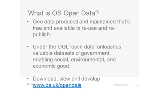
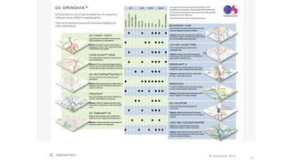
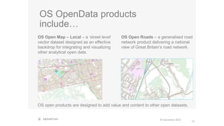
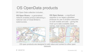
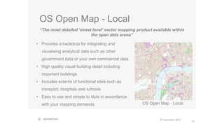
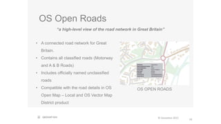
SlideShare a Scribd company logo
© Geovation 2015 | Confidential Last updated: 22 October 2015 11:45 AM
C H A L L E N G E 2 0 1 5 :
WAT E R
O P E N D ATA
M A S T E R C L A S S
© Geovation 2015
2
Who are
Ordnance Survey?
OS is Britain’s mapping agency – since
1791.
224 years later, OS is now an internationally
leading digital, big data powerhouse for
geographic information (GI) and geospatial
technology.
© Geovation 2015
3
© Geovation 2015
4
2 minute Video – OS: Finding a Way
© Geovation 2015
5
460,000,000
Almost 500 million topography features available in OS MasterMap
Topography Layer
OS Products and
Services
© Geovation 2015
6
10,000
Typically 10,000 updates per day
OS Products and
Services
© Geovation 2015
7
99.9% of new real world features are updated in the database within 6 months of their development.
99.9%
OS Products and
Services
Try our paid-for, premium
products…
© Geovation 2015
8
Why not download free samples of OS datasets today?
OS MasterMap Topography Layer OS MasterMap Water Network AddressBase Premium
You can download sample data files for paid-for OS products and use them in your
software applications today, the sample data is available from the OS website HERE
What is OS Open Data?
© Geovation 2015
• Geo data produced and maintained that’s
free and available to re-use and re-
publish.
• Under the OGL ‘open data’ unleashes
valuable datasets of government,
enabling social, environmental, and
economic good.
• Download, view and develop
www.os.uk/opendata 9
OS Open Data
© Geovation 2015
Making available some of Britain’s most comprehensive
mapping. Free, to get you started with geographic
information.
10
1
Download
2010: OS Open Data journey began
2015: Now 16 available open data
products
a minute!
11
© Geovation 2015
OS OpenData products
include…
OS open products are designed to add value and content to other open datasets.
© Geovation 2015
12
OS Open Map – Local – a ‘street level’
vector dataset designed as an effective
backdrop for integrating and visualizing
other analytical open data.
.
OS Open Roads – a generalised road
network product delivering a national
view of Great Britain’s road network.
OS OpenData products
OS Open Data collection includes…
OS open products are designed to add value and content to other open
datasets.
© Geovation 2015
13
OS Open Rivers – a generalised
network enabled product delivering a
national view of Great Britain’s
watercourses.
OS Open Names – a significant
upgrade to our legacy gazetteer
products for use in location searches
on both mobile and web – giving the
most up to date available place
names, road names, road numbers
and postcodes.
OS Open Map - Local
15
© Geovation 2015
“The most detailed ‘street level’ vector mapping product available within
the open data arena”
OS Open Map - Local
• Provides a backdrop for integrating and
visualising analytical data such as other
government data or your own commercial data.
• High quality visual building detail including
important buildings.
• Includes extents of functional sites such as
transport, hospitals and schools
• Easy to use and simple to style in accordance
with your mapping demands.
OS Open Map - Local
16
© Geovation 2015
KEY BENEFITS
• Understand the full extent of your area with enhanced level of buildings details.
• Recognise the presence of key functional sites including areas such as
education and medical care.
• Undertake analytical activities in alignment with key information, such as
buildings, roads, railway lines, functional sties and more.
• Present accurate information consistently with other available open data
products.
OS Open Roads
18
© Geovation 2015
“a high-level view of the road network in Great Britain”
OS OPEN ROADS
• A connected road network for Great
Britain.
• Contains all classified roads (Motorway
and A & B Roads)
• Includes officially named unclassified
roads
• Compatible with the road details in OS
Open Map – Local and OS Vector Map
District product
OS Open Roads
19
KEY BENEFITS
• Generalised road geometry – ability to understand the road network with
generalised and accurate open road data in England and Wales.
• Allows the sharing of additional data – such as traffic congestion and
accident hotspots in context with the network.
• Enables quick, high level analysis of the network – get answers back
quickly.
• Uses official DfT classification – providing clarity to all users for road
classifications e.g. AA.
• Conforms to defined geospatial standards (INSPIRE) – meaning customers
can more easily set up their GIS systems and software, and it can be easily
shared between applications globally.
© Geovation 2015
OS Open Rivers
21
The only detailed, heightened water network of Great Britain showing the
flow and precise course of rivers, streams, lakes and canals
• A connected river network for Great
Britain
• Generalised from OS’ large-scale
watercourse data
• Shows locations of rivers, streams,
lakes, lochs and canals
• Highlights the direction of flow
• Compatible with the OS Open Map –
Local and OS Vector Map District
products
OS Open Rivers
© Geovation 2015
OS Open Rivers
22
© Geovation 2015
KEY BENEFITS
• Generalised water course geometry – ability to understand the water network
at a ‘high level’ with generalised geometry and network connectivity, using
‘Strahler’.
• Allows sharing of water network data with additional data – such as
flooding locations and pollution hotspots.
• Enables quick, high level analysis of the network – get answers back
quickly for simple water course understanding and flood calculations.
• Uses official water course name and number – providing clarity to the
different organisations for river names, enabling high level area planning,
accessibility planning, and sharing of data.
• Conforms to defined geospatial standards (INSPIRE)
OS Open Names
23
© Geovation 2015
OS Open Names
24
A simple search solution – enables accurate location searching
• Includes place names, road names, road
numbers and postcodes
• An enhancement on current OpenData
gazetteers, OS LocatorTM and OS 1:50 000
Gazetteer, with…
• Improved accuracy
• Better quality content
• More frequent updates
• Also available via an API. OS Open Names
© Geovation 2015
25
© Geovation 2015
26
© Geovation 2015
Case studies: previous
Geovation winners
29
© Geovation 2015
Real Food Wales A unique network of local knowledge and interactive mapping
using OS Vector Map, Street View, Boundary-Line, Strategi and Land-Form
PANORAMA to showcase over 150 best food businesses along the Wales coast
path, in Pembrokeshire.
City Farmers Using OS and open data, local social, economic and environmental
‘topography’ has been visualised to frame problems between local government
and communities on sustainability issues, helping shape small-scale social
enterprise to support and celebrate local growing.
Run An Empire An exercise strategy app game, using GPS with OS data to
record paths players take and allow people to compete to capture and maintain
control of as much territory as possible – using neighbourhoods as arenas for play.
Open data = innovation
31
OS OpenData aims to help drive innovation and
Geovation Challenges have demonstrated this…
Possibility made even better with new OS OpenSpace API:
• Enabling you to embed and use OS maps for your
business or non-business website and mobile
applications
© Geovation 2015
OS, open data and water
This year’s Geovation Challenge is all about Water
© Geovation 2015
32
How can geographic
information be used as a
tool for water innovation?
We’ve got some water-related
open data sources to get you
thinking…
OS Open Rivers + EA water catchment districts and
management areas (in QGIS)
© Geovation 2015
33
Data source Dataset Theme
Ordnance Survey
(OS)
Local
Terrain 50
Rivers
Topography (Open)
Vector Map Local
Terrain 5
Water Network
Topography (Premium)
Boundary Line
Address Base
Administrative (Open)
AddressBase
Places
Administrative (Premium)
Consumer indications
Environment Agency
(EA)
River basin districts Administrative
Catchment management areas
Agricultural land use
LIDAR/land cover
Topography
Water resource availability (sub-catchment
level)
Water abstraction by purpose
Waterbody ecological status
Resource statistics
Flood risk zones Risks
OS, OPEN DATA &
WATER
© Geovation 2015
34
Data source Dataset Theme
Defra/JNCC
(INSPIRE data.gov.uk)
Habitats and species
Bathing waters
Ecology
Forestry Commission National forests Ecology
Waterfootprint.org Crop (food) water foot prints by local Resource statistics
Office for National
Statistics
(ONS)
Resident population by sub-ward
Work place population by ward
Households by sub-ward
Demographic statistics
Consumer indications
Centre for Ecology and
Hydrology (CEH)
Hydrology e.g. catchment chemistry
Land use
Resource statistics
Infrastructural indications
British Geological
(BGS)
Geology and hydrology e.g. groundwater, Resource statistics
Met Office Weather prediction models
Observational data
Rainfall
Satellite data
Weather (DataPoint API)
Regional…
e.g. London Datastore
(Greater London
Authority)
London water quality by borough Resource statistics
OS, OPEN DATA &
WATER
Could you be the next Geovation innovator?
The open data is in your hands.
© Geovation 2015
35
Thank you
www.geovation.uk
© Geovation 2015
36

More Related Content

What's hot

Galileo: System and Applications
Galileo: System and ApplicationsGalileo: System and Applications
Galileo: System and Applications
Marco Lisi
 
Ecosystem assessment and accounting in the context of SDG 15 Hans Dufourmont EEA
Ecosystem assessment and accounting in the context of SDG 15 Hans Dufourmont EEAEcosystem assessment and accounting in the context of SDG 15 Hans Dufourmont EEA
Ecosystem assessment and accounting in the context of SDG 15 Hans Dufourmont EEA
The European GNSS Agency (GSA)
 
Geoland2 Workshop - 01 - sousa
Geoland2 Workshop - 01 - sousaGeoland2 Workshop - 01 - sousa
Geoland2 Workshop - 01 - sousa
Planetek Italia Srl
 
Change detection
Change detection Change detection
Change detection
manoj1412001
 
High Resolution Site Characterization (#HRSC) of Gasoline LNAPL Plume Migrati...
High Resolution Site Characterization (#HRSC) of Gasoline LNAPL Plume Migrati...High Resolution Site Characterization (#HRSC) of Gasoline LNAPL Plume Migrati...
High Resolution Site Characterization (#HRSC) of Gasoline LNAPL Plume Migrati...
John Fontana
 
Land Use/Land Cover Detection
Land Use/Land Cover DetectionLand Use/Land Cover Detection
Land Use/Land Cover DetectionWansoo Im
 
Census Update Webinar: Census Geography Tools
Census Update Webinar: Census Geography ToolsCensus Update Webinar: Census Geography Tools
Census Update Webinar: Census Geography Tools
EDINA, University of Edinburgh
 
AHN: The need for a nation wide digital elevation model
AHN: The need for a nation wide digital elevation modelAHN: The need for a nation wide digital elevation model
AHN: The need for a nation wide digital elevation modelNielsVanDerZon
 
Are Dutch Internet Paths Local - A Measurement Study Using RIPE Atlas
Are Dutch Internet Paths Local - A Measurement Study Using RIPE AtlasAre Dutch Internet Paths Local - A Measurement Study Using RIPE Atlas
Are Dutch Internet Paths Local - A Measurement Study Using RIPE Atlas
RIPE NCC
 
Using telematics data to research traffic related air pollution
Using telematics data to research traffic related air pollutionUsing telematics data to research traffic related air pollution
Using telematics data to research traffic related air pollution
Institute for Transport Studies (ITS)
 
Lesson 2. Field validation
Lesson 2. Field validation Lesson 2. Field validation
Lesson 2. Field validation
Colleen Curran
 
The State of the (Romanian) Internet
The State of the (Romanian) InternetThe State of the (Romanian) Internet
The State of the (Romanian) Internet
RIPE NCC
 
APPLICATIONS OF RS AND GIS FOR DEVELOPMENT OF SMALL HYDROPOWER PLANTS (SHP)
APPLICATIONS OF RS AND GIS  FOR DEVELOPMENT OF SMALL HYDROPOWER PLANTS (SHP)APPLICATIONS OF RS AND GIS  FOR DEVELOPMENT OF SMALL HYDROPOWER PLANTS (SHP)
APPLICATIONS OF RS AND GIS FOR DEVELOPMENT OF SMALL HYDROPOWER PLANTS (SHP)Abhiram Kanigolla
 
Integration of mega projects into the existing network – the critical role of...
Integration of mega projects into the existing network – the critical role of...Integration of mega projects into the existing network – the critical role of...
Integration of mega projects into the existing network – the critical role of...
JumpingJaq
 
The GNSS-R soil moisture mapping drone: Helping farmers to make better decisi...
The GNSS-R soil moisture mapping drone: Helping farmers to make better decisi...The GNSS-R soil moisture mapping drone: Helping farmers to make better decisi...
The GNSS-R soil moisture mapping drone: Helping farmers to make better decisi...
Mistrale_eu
 
Geonames.engl
Geonames.englGeonames.engl
Geonames.engl
Irena Švehlová
 
Christchurch (NZ) Transportation Models Update - A Moving Feast
Christchurch (NZ) Transportation Models Update - A Moving FeastChristchurch (NZ) Transportation Models Update - A Moving Feast
Christchurch (NZ) Transportation Models Update - A Moving Feast
JumpingJaq
 
IXP-Jedi - finding routing issues
IXP-Jedi - finding routing issuesIXP-Jedi - finding routing issues
IXP-Jedi - finding routing issues
Internet Society
 
Police Facility Conceptual Design
Police Facility Conceptual DesignPolice Facility Conceptual Design
Police Facility Conceptual Design
City of College Station
 

What's hot (20)

Galileo: System and Applications
Galileo: System and ApplicationsGalileo: System and Applications
Galileo: System and Applications
 
Ecosystem assessment and accounting in the context of SDG 15 Hans Dufourmont EEA
Ecosystem assessment and accounting in the context of SDG 15 Hans Dufourmont EEAEcosystem assessment and accounting in the context of SDG 15 Hans Dufourmont EEA
Ecosystem assessment and accounting in the context of SDG 15 Hans Dufourmont EEA
 
Geoland2 Workshop - 01 - sousa
Geoland2 Workshop - 01 - sousaGeoland2 Workshop - 01 - sousa
Geoland2 Workshop - 01 - sousa
 
Change detection
Change detection Change detection
Change detection
 
URISA_MTO_LMS_2014_BeSpatial
URISA_MTO_LMS_2014_BeSpatialURISA_MTO_LMS_2014_BeSpatial
URISA_MTO_LMS_2014_BeSpatial
 
High Resolution Site Characterization (#HRSC) of Gasoline LNAPL Plume Migrati...
High Resolution Site Characterization (#HRSC) of Gasoline LNAPL Plume Migrati...High Resolution Site Characterization (#HRSC) of Gasoline LNAPL Plume Migrati...
High Resolution Site Characterization (#HRSC) of Gasoline LNAPL Plume Migrati...
 
Land Use/Land Cover Detection
Land Use/Land Cover DetectionLand Use/Land Cover Detection
Land Use/Land Cover Detection
 
Census Update Webinar: Census Geography Tools
Census Update Webinar: Census Geography ToolsCensus Update Webinar: Census Geography Tools
Census Update Webinar: Census Geography Tools
 
AHN: The need for a nation wide digital elevation model
AHN: The need for a nation wide digital elevation modelAHN: The need for a nation wide digital elevation model
AHN: The need for a nation wide digital elevation model
 
Are Dutch Internet Paths Local - A Measurement Study Using RIPE Atlas
Are Dutch Internet Paths Local - A Measurement Study Using RIPE AtlasAre Dutch Internet Paths Local - A Measurement Study Using RIPE Atlas
Are Dutch Internet Paths Local - A Measurement Study Using RIPE Atlas
 
Using telematics data to research traffic related air pollution
Using telematics data to research traffic related air pollutionUsing telematics data to research traffic related air pollution
Using telematics data to research traffic related air pollution
 
Lesson 2. Field validation
Lesson 2. Field validation Lesson 2. Field validation
Lesson 2. Field validation
 
The State of the (Romanian) Internet
The State of the (Romanian) InternetThe State of the (Romanian) Internet
The State of the (Romanian) Internet
 
APPLICATIONS OF RS AND GIS FOR DEVELOPMENT OF SMALL HYDROPOWER PLANTS (SHP)
APPLICATIONS OF RS AND GIS  FOR DEVELOPMENT OF SMALL HYDROPOWER PLANTS (SHP)APPLICATIONS OF RS AND GIS  FOR DEVELOPMENT OF SMALL HYDROPOWER PLANTS (SHP)
APPLICATIONS OF RS AND GIS FOR DEVELOPMENT OF SMALL HYDROPOWER PLANTS (SHP)
 
Integration of mega projects into the existing network – the critical role of...
Integration of mega projects into the existing network – the critical role of...Integration of mega projects into the existing network – the critical role of...
Integration of mega projects into the existing network – the critical role of...
 
The GNSS-R soil moisture mapping drone: Helping farmers to make better decisi...
The GNSS-R soil moisture mapping drone: Helping farmers to make better decisi...The GNSS-R soil moisture mapping drone: Helping farmers to make better decisi...
The GNSS-R soil moisture mapping drone: Helping farmers to make better decisi...
 
Geonames.engl
Geonames.englGeonames.engl
Geonames.engl
 
Christchurch (NZ) Transportation Models Update - A Moving Feast
Christchurch (NZ) Transportation Models Update - A Moving FeastChristchurch (NZ) Transportation Models Update - A Moving Feast
Christchurch (NZ) Transportation Models Update - A Moving Feast
 
IXP-Jedi - finding routing issues
IXP-Jedi - finding routing issuesIXP-Jedi - finding routing issues
IXP-Jedi - finding routing issues
 
Police Facility Conceptual Design
Police Facility Conceptual DesignPolice Facility Conceptual Design
Police Facility Conceptual Design
 

Similar to Geovation Water Challenge: OS Open Data

Ordnance Survey - Esri UK Annual Conference 2016
Ordnance Survey - Esri UK Annual Conference 2016Ordnance Survey - Esri UK Annual Conference 2016
Ordnance Survey - Esri UK Annual Conference 2016
Esri UK
 
OS OpenData masterclass presentation
OS OpenData masterclass presentationOS OpenData masterclass presentation
OS OpenData masterclass presentationLuke Hampson
 
Application packaging and systematic processing in earth observation exploita...
Application packaging and systematic processing in earth observation exploita...Application packaging and systematic processing in earth observation exploita...
Application packaging and systematic processing in earth observation exploita...
terradue
 
#FiaComit Cobra Resiliance Direct
#FiaComit Cobra Resiliance Direct#FiaComit Cobra Resiliance Direct
#FiaComit Cobra Resiliance Direct
Comit Projects Ltd
 
Tim Martin on OS OpenSpace
Tim Martin on OS OpenSpaceTim Martin on OS OpenSpace
Tim Martin on OS OpenSpace
West Midlands Regional Observatory
 
Diaz Collect Earth remote sensing activity data Nov 10 2014
Diaz Collect Earth remote sensing activity data Nov 10 2014Diaz Collect Earth remote sensing activity data Nov 10 2014
Diaz Collect Earth remote sensing activity data Nov 10 2014
CCAFS | CGIAR Research Program on Climate Change, Agriculture and Food Security
 
Open Geographies and Open Software
Open Geographies and Open SoftwareOpen Geographies and Open Software
Open Geographies and Open Software
James Crone
 
SDSC Technology Forum: Increasing the Impact of High Resolution Topography Da...
SDSC Technology Forum: Increasing the Impact of High Resolution Topography Da...SDSC Technology Forum: Increasing the Impact of High Resolution Topography Da...
SDSC Technology Forum: Increasing the Impact of High Resolution Topography Da...
OpenTopography Facility
 
EDINA National Datacentre Activity Update to GWG
EDINA National Datacentre Activity Update to GWGEDINA National Datacentre Activity Update to GWG
EDINA National Datacentre Activity Update to GWG
EDINA, University of Edinburgh
 
2016 GMekong Forum - Session 6 - Intro to SERVIR Mekong and dam inundation pr...
2016 GMekong Forum - Session 6 - Intro to SERVIR Mekong and dam inundation pr...2016 GMekong Forum - Session 6 - Intro to SERVIR Mekong and dam inundation pr...
2016 GMekong Forum - Session 6 - Intro to SERVIR Mekong and dam inundation pr...
Water, Land and Ecosystems (WLE)
 
Full planning support system at your fingertips mvopc p&z_120712
Full planning support system at your fingertips mvopc p&z_120712Full planning support system at your fingertips mvopc p&z_120712
Full planning support system at your fingertips mvopc p&z_120712
MVRPC
 
Bruce Thompson on digital disruption and the environment
Bruce Thompson on digital disruption and the environment Bruce Thompson on digital disruption and the environment
Bruce Thompson on digital disruption and the environment
OCESAdmin
 
Dotted Eyes - Open Software, Standards and Data
Dotted Eyes - Open Software, Standards and DataDotted Eyes - Open Software, Standards and Data
Dotted Eyes - Open Software, Standards and DataDotted Eyes
 
Global Soil Data Task, part of Earth Data Sets - Vincent van Engelen
Global Soil Data Task, part of Earth Data Sets - Vincent van EngelenGlobal Soil Data Task, part of Earth Data Sets - Vincent van Engelen
Global Soil Data Task, part of Earth Data Sets - Vincent van Engelen
FAO
 
ISRSE37 Terradue Cloud Platform & ellip
ISRSE37 Terradue Cloud Platform & ellipISRSE37 Terradue Cloud Platform & ellip
ISRSE37 Terradue Cloud Platform & ellip
terradue
 
The Whitebox Geospatial-Analyisis Tools Project and Open-Access GIS
The Whitebox Geospatial-Analyisis Tools Project and Open-Access GISThe Whitebox Geospatial-Analyisis Tools Project and Open-Access GIS
The Whitebox Geospatial-Analyisis Tools Project and Open-Access GIS
Golgi Alvarez
 
iot-and-smart-cities-lea-blackstock
iot-and-smart-cities-lea-blackstockiot-and-smart-cities-lea-blackstock
iot-and-smart-cities-lea-blackstock
Michael Blackstock
 
01-05 EO Community Engagement.pdf
01-05 EO Community Engagement.pdf01-05 EO Community Engagement.pdf
01-05 EO Community Engagement.pdf
OCRE | Open Clouds for Research Environments
 
Adopting-smart_technology_for_enhancing_road_asset_performance_and_benchmarking
Adopting-smart_technology_for_enhancing_road_asset_performance_and_benchmarkingAdopting-smart_technology_for_enhancing_road_asset_performance_and_benchmarking
Adopting-smart_technology_for_enhancing_road_asset_performance_and_benchmarking
Ashish Shah
 

Similar to Geovation Water Challenge: OS Open Data (20)

Ordnance Survey - Esri UK Annual Conference 2016
Ordnance Survey - Esri UK Annual Conference 2016Ordnance Survey - Esri UK Annual Conference 2016
Ordnance Survey - Esri UK Annual Conference 2016
 
OS OpenData masterclass presentation
OS OpenData masterclass presentationOS OpenData masterclass presentation
OS OpenData masterclass presentation
 
Application packaging and systematic processing in earth observation exploita...
Application packaging and systematic processing in earth observation exploita...Application packaging and systematic processing in earth observation exploita...
Application packaging and systematic processing in earth observation exploita...
 
#FiaComit Cobra Resiliance Direct
#FiaComit Cobra Resiliance Direct#FiaComit Cobra Resiliance Direct
#FiaComit Cobra Resiliance Direct
 
Tim Martin on OS OpenSpace
Tim Martin on OS OpenSpaceTim Martin on OS OpenSpace
Tim Martin on OS OpenSpace
 
Diaz Collect Earth remote sensing activity data Nov 10 2014
Diaz Collect Earth remote sensing activity data Nov 10 2014Diaz Collect Earth remote sensing activity data Nov 10 2014
Diaz Collect Earth remote sensing activity data Nov 10 2014
 
Open Geographies and Open Software
Open Geographies and Open SoftwareOpen Geographies and Open Software
Open Geographies and Open Software
 
SDSC Technology Forum: Increasing the Impact of High Resolution Topography Da...
SDSC Technology Forum: Increasing the Impact of High Resolution Topography Da...SDSC Technology Forum: Increasing the Impact of High Resolution Topography Da...
SDSC Technology Forum: Increasing the Impact of High Resolution Topography Da...
 
EDINA National Datacentre Activity Update to GWG
EDINA National Datacentre Activity Update to GWGEDINA National Datacentre Activity Update to GWG
EDINA National Datacentre Activity Update to GWG
 
2016 GMekong Forum - Session 6 - Intro to SERVIR Mekong and dam inundation pr...
2016 GMekong Forum - Session 6 - Intro to SERVIR Mekong and dam inundation pr...2016 GMekong Forum - Session 6 - Intro to SERVIR Mekong and dam inundation pr...
2016 GMekong Forum - Session 6 - Intro to SERVIR Mekong and dam inundation pr...
 
Full planning support system at your fingertips mvopc p&z_120712
Full planning support system at your fingertips mvopc p&z_120712Full planning support system at your fingertips mvopc p&z_120712
Full planning support system at your fingertips mvopc p&z_120712
 
Bruce Thompson on digital disruption and the environment
Bruce Thompson on digital disruption and the environment Bruce Thompson on digital disruption and the environment
Bruce Thompson on digital disruption and the environment
 
Dotted Eyes - Open Software, Standards and Data
Dotted Eyes - Open Software, Standards and DataDotted Eyes - Open Software, Standards and Data
Dotted Eyes - Open Software, Standards and Data
 
Global Soil Data Task, part of Earth Data Sets - Vincent van Engelen
Global Soil Data Task, part of Earth Data Sets - Vincent van EngelenGlobal Soil Data Task, part of Earth Data Sets - Vincent van Engelen
Global Soil Data Task, part of Earth Data Sets - Vincent van Engelen
 
Earth Science Data and Information System (ESDIS) Project Update
Earth Science Data and Information System (ESDIS) Project UpdateEarth Science Data and Information System (ESDIS) Project Update
Earth Science Data and Information System (ESDIS) Project Update
 
ISRSE37 Terradue Cloud Platform & ellip
ISRSE37 Terradue Cloud Platform & ellipISRSE37 Terradue Cloud Platform & ellip
ISRSE37 Terradue Cloud Platform & ellip
 
The Whitebox Geospatial-Analyisis Tools Project and Open-Access GIS
The Whitebox Geospatial-Analyisis Tools Project and Open-Access GISThe Whitebox Geospatial-Analyisis Tools Project and Open-Access GIS
The Whitebox Geospatial-Analyisis Tools Project and Open-Access GIS
 
iot-and-smart-cities-lea-blackstock
iot-and-smart-cities-lea-blackstockiot-and-smart-cities-lea-blackstock
iot-and-smart-cities-lea-blackstock
 
01-05 EO Community Engagement.pdf
01-05 EO Community Engagement.pdf01-05 EO Community Engagement.pdf
01-05 EO Community Engagement.pdf
 
Adopting-smart_technology_for_enhancing_road_asset_performance_and_benchmarking
Adopting-smart_technology_for_enhancing_road_asset_performance_and_benchmarkingAdopting-smart_technology_for_enhancing_road_asset_performance_and_benchmarking
Adopting-smart_technology_for_enhancing_road_asset_performance_and_benchmarking
 

More from Geovationchallenge

Geovation Water Challenge: Joining Data by Location, John Murray
Geovation Water Challenge: Joining Data by Location, John MurrayGeovation Water Challenge: Joining Data by Location, John Murray
Geovation Water Challenge: Joining Data by Location, John Murray
Geovationchallenge
 
Geovation Water Challenge: Environment Agency - Flooding
Geovation Water Challenge: Environment Agency - FloodingGeovation Water Challenge: Environment Agency - Flooding
Geovation Water Challenge: Environment Agency - Flooding
Geovationchallenge
 
Geovation Water Challenge: Environment Agency
Geovation Water Challenge: Environment AgencyGeovation Water Challenge: Environment Agency
Geovation Water Challenge: Environment Agency
Geovationchallenge
 
Geovation Water Challenge: British Geological Survey
Geovation Water Challenge: British Geological SurveyGeovation Water Challenge: British Geological Survey
Geovation Water Challenge: British Geological Survey
Geovationchallenge
 
Geovation Water Challenge: Trend Watching
Geovation Water Challenge: Trend WatchingGeovation Water Challenge: Trend Watching
Geovation Water Challenge: Trend Watching
Geovationchallenge
 
Geovation Water Challenge: Roundfield
Geovation Water Challenge:  RoundfieldGeovation Water Challenge:  Roundfield
Geovation Water Challenge: Roundfield
Geovationchallenge
 
Geovation Water Challenge: Produce World Group
Geovation Water Challenge: Produce World GroupGeovation Water Challenge: Produce World Group
Geovation Water Challenge: Produce World Group
Geovationchallenge
 
Geovation Water Challenge: Open Data Masterclass
Geovation Water Challenge: Open Data MasterclassGeovation Water Challenge: Open Data Masterclass
Geovation Water Challenge: Open Data Masterclass
Geovationchallenge
 
Geovation Water Challenge: An Ofwat perspective
Geovation Water Challenge: An Ofwat perspectiveGeovation Water Challenge: An Ofwat perspective
Geovation Water Challenge: An Ofwat perspective
Geovationchallenge
 
Geovation Water Challenge: Use of spatial data in SEPA
Geovation Water Challenge: Use of spatial data in SEPAGeovation Water Challenge: Use of spatial data in SEPA
Geovation Water Challenge: Use of spatial data in SEPA
Geovationchallenge
 
Exploring the Water Challenge: Waterless Toilets - Cranfield University
Exploring the Water Challenge: Waterless Toilets - Cranfield UniversityExploring the Water Challenge: Waterless Toilets - Cranfield University
Exploring the Water Challenge: Waterless Toilets - Cranfield University
Geovationchallenge
 
Geovation Water Challenge: Abacus Agriculture
Geovation Water Challenge: Abacus AgricultureGeovation Water Challenge: Abacus Agriculture
Geovation Water Challenge: Abacus Agriculture
Geovationchallenge
 
Geovation - Water Challenge
Geovation - Water ChallengeGeovation - Water Challenge
Geovation - Water Challenge
Geovationchallenge
 
Geovation Water Challenge: United Utilities
Geovation Water Challenge: United UtilitiesGeovation Water Challenge: United Utilities
Geovation Water Challenge: United Utilities
Geovationchallenge
 

More from Geovationchallenge (14)

Geovation Water Challenge: Joining Data by Location, John Murray
Geovation Water Challenge: Joining Data by Location, John MurrayGeovation Water Challenge: Joining Data by Location, John Murray
Geovation Water Challenge: Joining Data by Location, John Murray
 
Geovation Water Challenge: Environment Agency - Flooding
Geovation Water Challenge: Environment Agency - FloodingGeovation Water Challenge: Environment Agency - Flooding
Geovation Water Challenge: Environment Agency - Flooding
 
Geovation Water Challenge: Environment Agency
Geovation Water Challenge: Environment AgencyGeovation Water Challenge: Environment Agency
Geovation Water Challenge: Environment Agency
 
Geovation Water Challenge: British Geological Survey
Geovation Water Challenge: British Geological SurveyGeovation Water Challenge: British Geological Survey
Geovation Water Challenge: British Geological Survey
 
Geovation Water Challenge: Trend Watching
Geovation Water Challenge: Trend WatchingGeovation Water Challenge: Trend Watching
Geovation Water Challenge: Trend Watching
 
Geovation Water Challenge: Roundfield
Geovation Water Challenge:  RoundfieldGeovation Water Challenge:  Roundfield
Geovation Water Challenge: Roundfield
 
Geovation Water Challenge: Produce World Group
Geovation Water Challenge: Produce World GroupGeovation Water Challenge: Produce World Group
Geovation Water Challenge: Produce World Group
 
Geovation Water Challenge: Open Data Masterclass
Geovation Water Challenge: Open Data MasterclassGeovation Water Challenge: Open Data Masterclass
Geovation Water Challenge: Open Data Masterclass
 
Geovation Water Challenge: An Ofwat perspective
Geovation Water Challenge: An Ofwat perspectiveGeovation Water Challenge: An Ofwat perspective
Geovation Water Challenge: An Ofwat perspective
 
Geovation Water Challenge: Use of spatial data in SEPA
Geovation Water Challenge: Use of spatial data in SEPAGeovation Water Challenge: Use of spatial data in SEPA
Geovation Water Challenge: Use of spatial data in SEPA
 
Exploring the Water Challenge: Waterless Toilets - Cranfield University
Exploring the Water Challenge: Waterless Toilets - Cranfield UniversityExploring the Water Challenge: Waterless Toilets - Cranfield University
Exploring the Water Challenge: Waterless Toilets - Cranfield University
 
Geovation Water Challenge: Abacus Agriculture
Geovation Water Challenge: Abacus AgricultureGeovation Water Challenge: Abacus Agriculture
Geovation Water Challenge: Abacus Agriculture
 
Geovation - Water Challenge
Geovation - Water ChallengeGeovation - Water Challenge
Geovation - Water Challenge
 
Geovation Water Challenge: United Utilities
Geovation Water Challenge: United UtilitiesGeovation Water Challenge: United Utilities
Geovation Water Challenge: United Utilities
 

Recently uploaded

一比一原版(Deakin毕业证书)迪肯大学毕业证如何办理
一比一原版(Deakin毕业证书)迪肯大学毕业证如何办理一比一原版(Deakin毕业证书)迪肯大学毕业证如何办理
一比一原版(Deakin毕业证书)迪肯大学毕业证如何办理
oz8q3jxlp
 
一比一原版(QU毕业证)皇后大学毕业证成绩单
一比一原版(QU毕业证)皇后大学毕业证成绩单一比一原版(QU毕业证)皇后大学毕业证成绩单
一比一原版(QU毕业证)皇后大学毕业证成绩单
enxupq
 
Malana- Gimlet Market Analysis (Portfolio 2)
Malana- Gimlet Market Analysis (Portfolio 2)Malana- Gimlet Market Analysis (Portfolio 2)
Malana- Gimlet Market Analysis (Portfolio 2)
TravisMalana
 
Algorithmic optimizations for Dynamic Levelwise PageRank (from STICD) : SHORT...
Algorithmic optimizations for Dynamic Levelwise PageRank (from STICD) : SHORT...Algorithmic optimizations for Dynamic Levelwise PageRank (from STICD) : SHORT...
Algorithmic optimizations for Dynamic Levelwise PageRank (from STICD) : SHORT...
Subhajit Sahu
 
一比一原版(Bradford毕业证书)布拉德福德大学毕业证如何办理
一比一原版(Bradford毕业证书)布拉德福德大学毕业证如何办理一比一原版(Bradford毕业证书)布拉德福德大学毕业证如何办理
一比一原版(Bradford毕业证书)布拉德福德大学毕业证如何办理
mbawufebxi
 
做(mqu毕业证书)麦考瑞大学毕业证硕士文凭证书学费发票原版一模一样
做(mqu毕业证书)麦考瑞大学毕业证硕士文凭证书学费发票原版一模一样做(mqu毕业证书)麦考瑞大学毕业证硕士文凭证书学费发票原版一模一样
做(mqu毕业证书)麦考瑞大学毕业证硕士文凭证书学费发票原版一模一样
axoqas
 
The affect of service quality and online reviews on customer loyalty in the E...
The affect of service quality and online reviews on customer loyalty in the E...The affect of service quality and online reviews on customer loyalty in the E...
The affect of service quality and online reviews on customer loyalty in the E...
jerlynmaetalle
 
一比一原版(ArtEZ毕业证)ArtEZ艺术学院毕业证成绩单
一比一原版(ArtEZ毕业证)ArtEZ艺术学院毕业证成绩单一比一原版(ArtEZ毕业证)ArtEZ艺术学院毕业证成绩单
一比一原版(ArtEZ毕业证)ArtEZ艺术学院毕业证成绩单
vcaxypu
 
一比一原版(UPenn毕业证)宾夕法尼亚大学毕业证成绩单
一比一原版(UPenn毕业证)宾夕法尼亚大学毕业证成绩单一比一原版(UPenn毕业证)宾夕法尼亚大学毕业证成绩单
一比一原版(UPenn毕业证)宾夕法尼亚大学毕业证成绩单
ewymefz
 
一比一原版(UMich毕业证)密歇根大学|安娜堡分校毕业证成绩单
一比一原版(UMich毕业证)密歇根大学|安娜堡分校毕业证成绩单一比一原版(UMich毕业证)密歇根大学|安娜堡分校毕业证成绩单
一比一原版(UMich毕业证)密歇根大学|安娜堡分校毕业证成绩单
ewymefz
 
一比一原版(UofM毕业证)明尼苏达大学毕业证成绩单
一比一原版(UofM毕业证)明尼苏达大学毕业证成绩单一比一原版(UofM毕业证)明尼苏达大学毕业证成绩单
一比一原版(UofM毕业证)明尼苏达大学毕业证成绩单
ewymefz
 
Best best suvichar in gujarati english meaning of this sentence as Silk road ...
Best best suvichar in gujarati english meaning of this sentence as Silk road ...Best best suvichar in gujarati english meaning of this sentence as Silk road ...
Best best suvichar in gujarati english meaning of this sentence as Silk road ...
AbhimanyuSinha9
 
原版制作(Deakin毕业证书)迪肯大学毕业证学位证一模一样
原版制作(Deakin毕业证书)迪肯大学毕业证学位证一模一样原版制作(Deakin毕业证书)迪肯大学毕业证学位证一模一样
原版制作(Deakin毕业证书)迪肯大学毕业证学位证一模一样
u86oixdj
 
一比一原版(IIT毕业证)伊利诺伊理工大学毕业证成绩单
一比一原版(IIT毕业证)伊利诺伊理工大学毕业证成绩单一比一原版(IIT毕业证)伊利诺伊理工大学毕业证成绩单
一比一原版(IIT毕业证)伊利诺伊理工大学毕业证成绩单
ewymefz
 
Criminal IP - Threat Hunting Webinar.pdf
Criminal IP - Threat Hunting Webinar.pdfCriminal IP - Threat Hunting Webinar.pdf
Criminal IP - Threat Hunting Webinar.pdf
Criminal IP
 
standardisation of garbhpala offhgfffghh
standardisation of garbhpala offhgfffghhstandardisation of garbhpala offhgfffghh
standardisation of garbhpala offhgfffghh
ArpitMalhotra16
 
一比一原版(Adelaide毕业证书)阿德莱德大学毕业证如何办理
一比一原版(Adelaide毕业证书)阿德莱德大学毕业证如何办理一比一原版(Adelaide毕业证书)阿德莱德大学毕业证如何办理
一比一原版(Adelaide毕业证书)阿德莱德大学毕业证如何办理
slg6lamcq
 
SOCRadar Germany 2024 Threat Landscape Report
SOCRadar Germany 2024 Threat Landscape ReportSOCRadar Germany 2024 Threat Landscape Report
SOCRadar Germany 2024 Threat Landscape Report
SOCRadar
 
一比一原版(YU毕业证)约克大学毕业证成绩单
一比一原版(YU毕业证)约克大学毕业证成绩单一比一原版(YU毕业证)约克大学毕业证成绩单
一比一原版(YU毕业证)约克大学毕业证成绩单
enxupq
 
Sample_Global Non-invasive Prenatal Testing (NIPT) Market, 2019-2030.pdf
Sample_Global Non-invasive Prenatal Testing (NIPT) Market, 2019-2030.pdfSample_Global Non-invasive Prenatal Testing (NIPT) Market, 2019-2030.pdf
Sample_Global Non-invasive Prenatal Testing (NIPT) Market, 2019-2030.pdf
Linda486226
 

Recently uploaded (20)

一比一原版(Deakin毕业证书)迪肯大学毕业证如何办理
一比一原版(Deakin毕业证书)迪肯大学毕业证如何办理一比一原版(Deakin毕业证书)迪肯大学毕业证如何办理
一比一原版(Deakin毕业证书)迪肯大学毕业证如何办理
 
一比一原版(QU毕业证)皇后大学毕业证成绩单
一比一原版(QU毕业证)皇后大学毕业证成绩单一比一原版(QU毕业证)皇后大学毕业证成绩单
一比一原版(QU毕业证)皇后大学毕业证成绩单
 
Malana- Gimlet Market Analysis (Portfolio 2)
Malana- Gimlet Market Analysis (Portfolio 2)Malana- Gimlet Market Analysis (Portfolio 2)
Malana- Gimlet Market Analysis (Portfolio 2)
 
Algorithmic optimizations for Dynamic Levelwise PageRank (from STICD) : SHORT...
Algorithmic optimizations for Dynamic Levelwise PageRank (from STICD) : SHORT...Algorithmic optimizations for Dynamic Levelwise PageRank (from STICD) : SHORT...
Algorithmic optimizations for Dynamic Levelwise PageRank (from STICD) : SHORT...
 
一比一原版(Bradford毕业证书)布拉德福德大学毕业证如何办理
一比一原版(Bradford毕业证书)布拉德福德大学毕业证如何办理一比一原版(Bradford毕业证书)布拉德福德大学毕业证如何办理
一比一原版(Bradford毕业证书)布拉德福德大学毕业证如何办理
 
做(mqu毕业证书)麦考瑞大学毕业证硕士文凭证书学费发票原版一模一样
做(mqu毕业证书)麦考瑞大学毕业证硕士文凭证书学费发票原版一模一样做(mqu毕业证书)麦考瑞大学毕业证硕士文凭证书学费发票原版一模一样
做(mqu毕业证书)麦考瑞大学毕业证硕士文凭证书学费发票原版一模一样
 
The affect of service quality and online reviews on customer loyalty in the E...
The affect of service quality and online reviews on customer loyalty in the E...The affect of service quality and online reviews on customer loyalty in the E...
The affect of service quality and online reviews on customer loyalty in the E...
 
一比一原版(ArtEZ毕业证)ArtEZ艺术学院毕业证成绩单
一比一原版(ArtEZ毕业证)ArtEZ艺术学院毕业证成绩单一比一原版(ArtEZ毕业证)ArtEZ艺术学院毕业证成绩单
一比一原版(ArtEZ毕业证)ArtEZ艺术学院毕业证成绩单
 
一比一原版(UPenn毕业证)宾夕法尼亚大学毕业证成绩单
一比一原版(UPenn毕业证)宾夕法尼亚大学毕业证成绩单一比一原版(UPenn毕业证)宾夕法尼亚大学毕业证成绩单
一比一原版(UPenn毕业证)宾夕法尼亚大学毕业证成绩单
 
一比一原版(UMich毕业证)密歇根大学|安娜堡分校毕业证成绩单
一比一原版(UMich毕业证)密歇根大学|安娜堡分校毕业证成绩单一比一原版(UMich毕业证)密歇根大学|安娜堡分校毕业证成绩单
一比一原版(UMich毕业证)密歇根大学|安娜堡分校毕业证成绩单
 
一比一原版(UofM毕业证)明尼苏达大学毕业证成绩单
一比一原版(UofM毕业证)明尼苏达大学毕业证成绩单一比一原版(UofM毕业证)明尼苏达大学毕业证成绩单
一比一原版(UofM毕业证)明尼苏达大学毕业证成绩单
 
Best best suvichar in gujarati english meaning of this sentence as Silk road ...
Best best suvichar in gujarati english meaning of this sentence as Silk road ...Best best suvichar in gujarati english meaning of this sentence as Silk road ...
Best best suvichar in gujarati english meaning of this sentence as Silk road ...
 
原版制作(Deakin毕业证书)迪肯大学毕业证学位证一模一样
原版制作(Deakin毕业证书)迪肯大学毕业证学位证一模一样原版制作(Deakin毕业证书)迪肯大学毕业证学位证一模一样
原版制作(Deakin毕业证书)迪肯大学毕业证学位证一模一样
 
一比一原版(IIT毕业证)伊利诺伊理工大学毕业证成绩单
一比一原版(IIT毕业证)伊利诺伊理工大学毕业证成绩单一比一原版(IIT毕业证)伊利诺伊理工大学毕业证成绩单
一比一原版(IIT毕业证)伊利诺伊理工大学毕业证成绩单
 
Criminal IP - Threat Hunting Webinar.pdf
Criminal IP - Threat Hunting Webinar.pdfCriminal IP - Threat Hunting Webinar.pdf
Criminal IP - Threat Hunting Webinar.pdf
 
standardisation of garbhpala offhgfffghh
standardisation of garbhpala offhgfffghhstandardisation of garbhpala offhgfffghh
standardisation of garbhpala offhgfffghh
 
一比一原版(Adelaide毕业证书)阿德莱德大学毕业证如何办理
一比一原版(Adelaide毕业证书)阿德莱德大学毕业证如何办理一比一原版(Adelaide毕业证书)阿德莱德大学毕业证如何办理
一比一原版(Adelaide毕业证书)阿德莱德大学毕业证如何办理
 
SOCRadar Germany 2024 Threat Landscape Report
SOCRadar Germany 2024 Threat Landscape ReportSOCRadar Germany 2024 Threat Landscape Report
SOCRadar Germany 2024 Threat Landscape Report
 
一比一原版(YU毕业证)约克大学毕业证成绩单
一比一原版(YU毕业证)约克大学毕业证成绩单一比一原版(YU毕业证)约克大学毕业证成绩单
一比一原版(YU毕业证)约克大学毕业证成绩单
 
Sample_Global Non-invasive Prenatal Testing (NIPT) Market, 2019-2030.pdf
Sample_Global Non-invasive Prenatal Testing (NIPT) Market, 2019-2030.pdfSample_Global Non-invasive Prenatal Testing (NIPT) Market, 2019-2030.pdf
Sample_Global Non-invasive Prenatal Testing (NIPT) Market, 2019-2030.pdf
 

Geovation Water Challenge: OS Open Data

  • 1. © Geovation 2015 | Confidential Last updated: 22 October 2015 11:45 AM
  • 2. C H A L L E N G E 2 0 1 5 : WAT E R O P E N D ATA M A S T E R C L A S S © Geovation 2015 2
  • 3. Who are Ordnance Survey? OS is Britain’s mapping agency – since 1791. 224 years later, OS is now an internationally leading digital, big data powerhouse for geographic information (GI) and geospatial technology. © Geovation 2015 3
  • 4. © Geovation 2015 4 2 minute Video – OS: Finding a Way
  • 5. © Geovation 2015 5 460,000,000 Almost 500 million topography features available in OS MasterMap Topography Layer OS Products and Services
  • 6. © Geovation 2015 6 10,000 Typically 10,000 updates per day OS Products and Services
  • 7. © Geovation 2015 7 99.9% of new real world features are updated in the database within 6 months of their development. 99.9% OS Products and Services
  • 8. Try our paid-for, premium products… © Geovation 2015 8 Why not download free samples of OS datasets today? OS MasterMap Topography Layer OS MasterMap Water Network AddressBase Premium You can download sample data files for paid-for OS products and use them in your software applications today, the sample data is available from the OS website HERE
  • 9. What is OS Open Data? © Geovation 2015 • Geo data produced and maintained that’s free and available to re-use and re- publish. • Under the OGL ‘open data’ unleashes valuable datasets of government, enabling social, environmental, and economic good. • Download, view and develop www.os.uk/opendata 9
  • 10. OS Open Data © Geovation 2015 Making available some of Britain’s most comprehensive mapping. Free, to get you started with geographic information. 10 1 Download 2010: OS Open Data journey began 2015: Now 16 available open data products a minute!
  • 12. OS OpenData products include… OS open products are designed to add value and content to other open datasets. © Geovation 2015 12 OS Open Map – Local – a ‘street level’ vector dataset designed as an effective backdrop for integrating and visualizing other analytical open data. . OS Open Roads – a generalised road network product delivering a national view of Great Britain’s road network.
  • 13. OS OpenData products OS Open Data collection includes… OS open products are designed to add value and content to other open datasets. © Geovation 2015 13 OS Open Rivers – a generalised network enabled product delivering a national view of Great Britain’s watercourses. OS Open Names – a significant upgrade to our legacy gazetteer products for use in location searches on both mobile and web – giving the most up to date available place names, road names, road numbers and postcodes.
  • 14. OS Open Map - Local 15 © Geovation 2015 “The most detailed ‘street level’ vector mapping product available within the open data arena” OS Open Map - Local • Provides a backdrop for integrating and visualising analytical data such as other government data or your own commercial data. • High quality visual building detail including important buildings. • Includes extents of functional sites such as transport, hospitals and schools • Easy to use and simple to style in accordance with your mapping demands.
  • 15. OS Open Map - Local 16 © Geovation 2015 KEY BENEFITS • Understand the full extent of your area with enhanced level of buildings details. • Recognise the presence of key functional sites including areas such as education and medical care. • Undertake analytical activities in alignment with key information, such as buildings, roads, railway lines, functional sties and more. • Present accurate information consistently with other available open data products.
  • 16. OS Open Roads 18 © Geovation 2015 “a high-level view of the road network in Great Britain” OS OPEN ROADS • A connected road network for Great Britain. • Contains all classified roads (Motorway and A & B Roads) • Includes officially named unclassified roads • Compatible with the road details in OS Open Map – Local and OS Vector Map District product
  • 17. OS Open Roads 19 KEY BENEFITS • Generalised road geometry – ability to understand the road network with generalised and accurate open road data in England and Wales. • Allows the sharing of additional data – such as traffic congestion and accident hotspots in context with the network. • Enables quick, high level analysis of the network – get answers back quickly. • Uses official DfT classification – providing clarity to all users for road classifications e.g. AA. • Conforms to defined geospatial standards (INSPIRE) – meaning customers can more easily set up their GIS systems and software, and it can be easily shared between applications globally. © Geovation 2015
  • 18. OS Open Rivers 21 The only detailed, heightened water network of Great Britain showing the flow and precise course of rivers, streams, lakes and canals • A connected river network for Great Britain • Generalised from OS’ large-scale watercourse data • Shows locations of rivers, streams, lakes, lochs and canals • Highlights the direction of flow • Compatible with the OS Open Map – Local and OS Vector Map District products OS Open Rivers © Geovation 2015
  • 19. OS Open Rivers 22 © Geovation 2015 KEY BENEFITS • Generalised water course geometry – ability to understand the water network at a ‘high level’ with generalised geometry and network connectivity, using ‘Strahler’. • Allows sharing of water network data with additional data – such as flooding locations and pollution hotspots. • Enables quick, high level analysis of the network – get answers back quickly for simple water course understanding and flood calculations. • Uses official water course name and number – providing clarity to the different organisations for river names, enabling high level area planning, accessibility planning, and sharing of data. • Conforms to defined geospatial standards (INSPIRE)
  • 20. OS Open Names 23 © Geovation 2015
  • 21. OS Open Names 24 A simple search solution – enables accurate location searching • Includes place names, road names, road numbers and postcodes • An enhancement on current OpenData gazetteers, OS LocatorTM and OS 1:50 000 Gazetteer, with… • Improved accuracy • Better quality content • More frequent updates • Also available via an API. OS Open Names © Geovation 2015
  • 24. Case studies: previous Geovation winners 29 © Geovation 2015 Real Food Wales A unique network of local knowledge and interactive mapping using OS Vector Map, Street View, Boundary-Line, Strategi and Land-Form PANORAMA to showcase over 150 best food businesses along the Wales coast path, in Pembrokeshire. City Farmers Using OS and open data, local social, economic and environmental ‘topography’ has been visualised to frame problems between local government and communities on sustainability issues, helping shape small-scale social enterprise to support and celebrate local growing. Run An Empire An exercise strategy app game, using GPS with OS data to record paths players take and allow people to compete to capture and maintain control of as much territory as possible – using neighbourhoods as arenas for play.
  • 25. Open data = innovation 31 OS OpenData aims to help drive innovation and Geovation Challenges have demonstrated this… Possibility made even better with new OS OpenSpace API: • Enabling you to embed and use OS maps for your business or non-business website and mobile applications © Geovation 2015
  • 26. OS, open data and water This year’s Geovation Challenge is all about Water © Geovation 2015 32 How can geographic information be used as a tool for water innovation? We’ve got some water-related open data sources to get you thinking… OS Open Rivers + EA water catchment districts and management areas (in QGIS)
  • 27. © Geovation 2015 33 Data source Dataset Theme Ordnance Survey (OS) Local Terrain 50 Rivers Topography (Open) Vector Map Local Terrain 5 Water Network Topography (Premium) Boundary Line Address Base Administrative (Open) AddressBase Places Administrative (Premium) Consumer indications Environment Agency (EA) River basin districts Administrative Catchment management areas Agricultural land use LIDAR/land cover Topography Water resource availability (sub-catchment level) Water abstraction by purpose Waterbody ecological status Resource statistics Flood risk zones Risks OS, OPEN DATA & WATER
  • 28. © Geovation 2015 34 Data source Dataset Theme Defra/JNCC (INSPIRE data.gov.uk) Habitats and species Bathing waters Ecology Forestry Commission National forests Ecology Waterfootprint.org Crop (food) water foot prints by local Resource statistics Office for National Statistics (ONS) Resident population by sub-ward Work place population by ward Households by sub-ward Demographic statistics Consumer indications Centre for Ecology and Hydrology (CEH) Hydrology e.g. catchment chemistry Land use Resource statistics Infrastructural indications British Geological (BGS) Geology and hydrology e.g. groundwater, Resource statistics Met Office Weather prediction models Observational data Rainfall Satellite data Weather (DataPoint API) Regional… e.g. London Datastore (Greater London Authority) London water quality by borough Resource statistics OS, OPEN DATA & WATER
  • 29. Could you be the next Geovation innovator? The open data is in your hands. © Geovation 2015 35