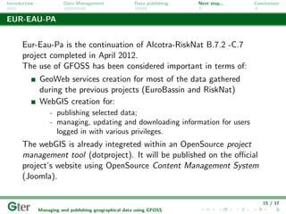
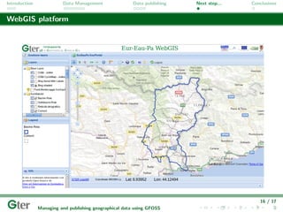
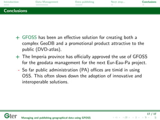
Introduction         Data Management            Data publishing    Next step...      Conclusions


               Managing and publishing geographical data
                            using GFOSS.
               The example of the Alcotra-RiskNat strategic project in
                   collaboration with the Imperia province, Italy.


               Asimina Syriou*, Roberto Marzocchi*, Tiziano Cosso*,
                      Bianca Federici**, Domenico Sguerso**

                         * Gter s.r.l. Innovazione in Geomatica, Gnss e Gis.
           ** Dept. of Civil, Chemistry and Environmental Engineering (DICCA - UNIGE).


                                       Genoa, February 7th, 2013
Introduction             Data Management                Data publishing   Next step...   Conclusions


Alcotra - RiskNat

       RiskNat
         is a cross-border project in the framework of the Alcotra France - Italy
                 program (2007-2013), developed between 2009 and 2012.
           RiskNat focuses on natural hazards such as earthquakes, landslides,
            torrent floods, snow avalanches, and hazards related to permafrost
                         degradation concerning mountain areas.


               All regions of western Alps (Italy, France and Switzerland)
                                      are involved.


                                                                                             1 / 17
               Managing and publishing geographical data using GFOSS
Introduction             Data Management                Data publishing   Next step...   Conclusions


Alcotra - RiskNat, Imperia

       Imperia province coordinated and developed a part of the RiskNat
       work related to the B.7.2 - C.7 framework:
          Vulnerability of Roia’s basin in terms of water resources management
                            related to different natural hazards.


         The mountain part of Roia’s
       watershed lies almost entirely in
      France, while the last part of the
      river crosses a small alluvial plain
     located in Italy (Ventimiglia). This
     not-confined acquifer is one of the
      main freshwater storages for both
      the Cote d’Azur and the Imperia
                   Province.

                                                                                             2 / 17
               Managing and publishing geographical data using GFOSS
Introduction             Data Management                Data publishing   Next step...   Conclusions


Methodology


      1   Data acquisition related to Roia basin.
      2   Metadata creation according to the INSPIRE
          guidelines and spesifications.
      3   Geographic database design and spatial
          information management.
      4   Data publication: sharing and editing
          geospatial data using open standards.
      5   Digital DVD atlas: browsing and quering
          various thematic layers of Roia basin and river.
      6   Preparation and implementation of a training
          course(+users guide) concerning GFOSS.
      7   Eur-Eau-Pa: continuation of the Alcotra -
          RiskNat project.

                                                                                             3 / 17
               Managing and publishing geographical data using GFOSS
Introduction             Data Management                Data publishing   Next step...   Conclusions


OpenSource Software (OSS) used


                          GRASS & QuantumGIS (QGIS) for vector and raster
                          data manupulation - GIS analysis.

                          GDAL library for reading and writing raster geospatial
                          data formats.

                          PostGIS for database (DB) management.

                          Geoserver for viewing and editing geospatial data.

                          OpenLayers library for displaying map data in the web
                          browser.


                                                                                             4 / 17
               Managing and publishing geographical data using GFOSS
Introduction             Data Management                Data publishing   Next step...   Conclusions


Census data


               Vector and raster data
               related to:
                    - probes, wells;
                    - trace sections of Roia
                      river - flow scenarios;
                    - potential pollution
                      source points - risk
                      scenarios;
               Cartographic catalog of
               Roia basin including both
               vector and raster layers.
               Alcotra - EUROBASSIN
               Project (2000-2006).


                                                                                             5 / 17
               Managing and publishing geographical data using GFOSS
Introduction             Data Management                Data publishing   Next step...   Conclusions


Importing vectors

       Data’s been created and/or imported on GRASS platform, in
       standardized storage format (lib. GDAL/ OGR), reference system
       Roma40 and map projection Gauss Boaga.


                                                                                             6 / 17
               Managing and publishing geographical data using GFOSS
Introduction             Data Management                Data publishing   Next step...   Conclusions


Metadata INSPIRE


                  Metadata files have been created implementing INSPIRE
                      (INfrastructure for SPatial InfoRmation in Europe)
                  guidelines and specifications, aiming to ensure cross-border
                        interoperability and sharing of geographic data.


                                                                                             7 / 17
               Managing and publishing geographical data using GFOSS
Introduction             Data Management                Data publishing   Next step...   Conclusions


Database


                                     Designed in a flexible and extensible way,
                                     optimizing data storage, without altering the
                                     original structure. OSS PostgreSQL has been
                                     used for the database management system
                                     (DBMS) and its spatial extention PostGIS.

                                     Geographic (georeferenced) data has been stored
                                     with both its spatial geometry and attributes.

                                     The DB can be consulted in tabular form using
                                     client interfaces such as pgAdmin III and can
                                     be also accessed directly using GIS Desktop.


                                                                                             8 / 17
               Managing and publishing geographical data using GFOSS
Introduction             Data Management                Data publishing   Next step...   Conclusions


Vector data geometry

       Storing vector data geometry:


                                                                                             9 / 17
               Managing and publishing geographical data using GFOSS
Introduction             Data Management                Data publishing   Next step...   Conclusions


Vector data metadata

       Storing metadata files associated with the vector layers:


                                                                                            10 / 17
               Managing and publishing geographical data using GFOSS
Introduction             Data Management                Data publishing   Next step...   Conclusions


Publishing on RiskNat geoportal


         Geodata creation in OGC Web Map Service (WPS) and Web Feature
        Service (WFS) format allowing users to navigate to RiskNat geoportal,
                            developed by ARPA-Piemonte.


                                                                                            11 / 17
               Managing and publishing geographical data using GFOSS
Introduction             Data Management                Data publishing   Next step...   Conclusions


System overview


                                                                                            12 / 17
               Managing and publishing geographical data using GFOSS
Introduction             Data Management                Data publishing   Next step...   Conclusions


Digital DVD Atlas


                                                                                            13 / 17
               Managing and publishing geographical data using GFOSS
Introduction             Data Management                Data publishing   Next step...   Conclusions


Training


               A training course has been
               conducted for the personnel of the
               Imperia province, focusing on the
               use of GFOSS and explaining the
               use of the entire system
               architecture:
                    - PostGIS
                    - QGIS


               Users guide creation and
               demonstration.


                                                                                            14 / 17
               Managing and publishing geographical data using GFOSS
Introduction             Data Management                Data publishing   Next step...   Conclusions


EUR-EAU-PA


       Eur-Eau-Pa is the continuation of Alcotra-RiskNat B.7.2 -C.7
       project completed in April 2012.
       The use of GFOSS has been considered important in terms of:
               GeoWeb services creation for most of the data gathered
               during the previous projects (EuroBassin and RiskNat)
               WebGIS creation for:
                    - publishing selected data;
                    - managing, updating and downloading information for users
                      logged in with various privileges.
       The webGIS is already integreted within an OpenSource project
       management tool (dotproject). It will be published on the official
       project’s website using OpenSource Content Management System
       (Joomla).


                                                                                            15 / 17
               Managing and publishing geographical data using GFOSS
Introduction             Data Management                Data publishing   Next step...   Conclusions


WebGIS platform


                                                                                            16 / 17
               Managing and publishing geographical data using GFOSS
Introduction             Data Management                Data publishing   Next step...   Conclusions


Conclusions


         + GFOSS has been an effective solution for creating both a
           complex GeoDB and a promotional product attractive to the
           public (DVD-atlas).
         + The Imperia province has officially approved the use of GFOSS
           for the geodata management for the next Eur-Eau-Pa project.
           - So far public administration (PA) offices are timid in using
             OSS. This often slows down the adoption of innovative and
             interoperable solutions.


                                                                                            17 / 17
               Managing and publishing geographical data using GFOSS
Introduction             Data Management                  Data publishing               Next step...              Conclusions


                                    That’s all folks!
                              Thank you for your attention!


                                                       info@gter.it

                                                    www.gter.it


       Quest’ opera ` distribuita con licenza Creative Commons Attribuzione - Condividi allo stesso modo 3.0 Unported.
                    e

RiskNat - foss4git

  • 1.
    Introduction Data Management Data publishing Next step... Conclusions Managing and publishing geographical data using GFOSS. The example of the Alcotra-RiskNat strategic project in collaboration with the Imperia province, Italy. Asimina Syriou*, Roberto Marzocchi*, Tiziano Cosso*, Bianca Federici**, Domenico Sguerso** * Gter s.r.l. Innovazione in Geomatica, Gnss e Gis. ** Dept. of Civil, Chemistry and Environmental Engineering (DICCA - UNIGE). Genoa, February 7th, 2013
  • 2.
    Introduction Data Management Data publishing Next step... Conclusions Alcotra - RiskNat RiskNat is a cross-border project in the framework of the Alcotra France - Italy program (2007-2013), developed between 2009 and 2012. RiskNat focuses on natural hazards such as earthquakes, landslides, torrent floods, snow avalanches, and hazards related to permafrost degradation concerning mountain areas. All regions of western Alps (Italy, France and Switzerland) are involved. 1 / 17 Managing and publishing geographical data using GFOSS
  • 3.
    Introduction Data Management Data publishing Next step... Conclusions Alcotra - RiskNat, Imperia Imperia province coordinated and developed a part of the RiskNat work related to the B.7.2 - C.7 framework: Vulnerability of Roia’s basin in terms of water resources management related to different natural hazards. The mountain part of Roia’s watershed lies almost entirely in France, while the last part of the river crosses a small alluvial plain located in Italy (Ventimiglia). This not-confined acquifer is one of the main freshwater storages for both the Cote d’Azur and the Imperia Province. 2 / 17 Managing and publishing geographical data using GFOSS
  • 4.
    Introduction Data Management Data publishing Next step... Conclusions Methodology 1 Data acquisition related to Roia basin. 2 Metadata creation according to the INSPIRE guidelines and spesifications. 3 Geographic database design and spatial information management. 4 Data publication: sharing and editing geospatial data using open standards. 5 Digital DVD atlas: browsing and quering various thematic layers of Roia basin and river. 6 Preparation and implementation of a training course(+users guide) concerning GFOSS. 7 Eur-Eau-Pa: continuation of the Alcotra - RiskNat project. 3 / 17 Managing and publishing geographical data using GFOSS
  • 5.
    Introduction Data Management Data publishing Next step... Conclusions OpenSource Software (OSS) used GRASS & QuantumGIS (QGIS) for vector and raster data manupulation - GIS analysis. GDAL library for reading and writing raster geospatial data formats. PostGIS for database (DB) management. Geoserver for viewing and editing geospatial data. OpenLayers library for displaying map data in the web browser. 4 / 17 Managing and publishing geographical data using GFOSS
  • 6.
    Introduction Data Management Data publishing Next step... Conclusions Census data Vector and raster data related to: - probes, wells; - trace sections of Roia river - flow scenarios; - potential pollution source points - risk scenarios; Cartographic catalog of Roia basin including both vector and raster layers. Alcotra - EUROBASSIN Project (2000-2006). 5 / 17 Managing and publishing geographical data using GFOSS
  • 7.
    Introduction Data Management Data publishing Next step... Conclusions Importing vectors Data’s been created and/or imported on GRASS platform, in standardized storage format (lib. GDAL/ OGR), reference system Roma40 and map projection Gauss Boaga. 6 / 17 Managing and publishing geographical data using GFOSS
  • 8.
    Introduction Data Management Data publishing Next step... Conclusions Metadata INSPIRE Metadata files have been created implementing INSPIRE (INfrastructure for SPatial InfoRmation in Europe) guidelines and specifications, aiming to ensure cross-border interoperability and sharing of geographic data. 7 / 17 Managing and publishing geographical data using GFOSS
  • 9.
    Introduction Data Management Data publishing Next step... Conclusions Database Designed in a flexible and extensible way, optimizing data storage, without altering the original structure. OSS PostgreSQL has been used for the database management system (DBMS) and its spatial extention PostGIS. Geographic (georeferenced) data has been stored with both its spatial geometry and attributes. The DB can be consulted in tabular form using client interfaces such as pgAdmin III and can be also accessed directly using GIS Desktop. 8 / 17 Managing and publishing geographical data using GFOSS
  • 10.
    Introduction Data Management Data publishing Next step... Conclusions Vector data geometry Storing vector data geometry: 9 / 17 Managing and publishing geographical data using GFOSS
  • 11.
    Introduction Data Management Data publishing Next step... Conclusions Vector data metadata Storing metadata files associated with the vector layers: 10 / 17 Managing and publishing geographical data using GFOSS
  • 12.
    Introduction Data Management Data publishing Next step... Conclusions Publishing on RiskNat geoportal Geodata creation in OGC Web Map Service (WPS) and Web Feature Service (WFS) format allowing users to navigate to RiskNat geoportal, developed by ARPA-Piemonte. 11 / 17 Managing and publishing geographical data using GFOSS
  • 13.
    Introduction Data Management Data publishing Next step... Conclusions System overview 12 / 17 Managing and publishing geographical data using GFOSS
  • 14.
    Introduction Data Management Data publishing Next step... Conclusions Digital DVD Atlas 13 / 17 Managing and publishing geographical data using GFOSS
  • 15.
    Introduction Data Management Data publishing Next step... Conclusions Training A training course has been conducted for the personnel of the Imperia province, focusing on the use of GFOSS and explaining the use of the entire system architecture: - PostGIS - QGIS Users guide creation and demonstration. 14 / 17 Managing and publishing geographical data using GFOSS
  • 16.
    Introduction Data Management Data publishing Next step... Conclusions EUR-EAU-PA Eur-Eau-Pa is the continuation of Alcotra-RiskNat B.7.2 -C.7 project completed in April 2012. The use of GFOSS has been considered important in terms of: GeoWeb services creation for most of the data gathered during the previous projects (EuroBassin and RiskNat) WebGIS creation for: - publishing selected data; - managing, updating and downloading information for users logged in with various privileges. The webGIS is already integreted within an OpenSource project management tool (dotproject). It will be published on the official project’s website using OpenSource Content Management System (Joomla). 15 / 17 Managing and publishing geographical data using GFOSS
  • 17.
    Introduction Data Management Data publishing Next step... Conclusions WebGIS platform 16 / 17 Managing and publishing geographical data using GFOSS
  • 18.
    Introduction Data Management Data publishing Next step... Conclusions Conclusions + GFOSS has been an effective solution for creating both a complex GeoDB and a promotional product attractive to the public (DVD-atlas). + The Imperia province has officially approved the use of GFOSS for the geodata management for the next Eur-Eau-Pa project. - So far public administration (PA) offices are timid in using OSS. This often slows down the adoption of innovative and interoperable solutions. 17 / 17 Managing and publishing geographical data using GFOSS
  • 19.
    Introduction Data Management Data publishing Next step... Conclusions That’s all folks! Thank you for your attention! info@gter.it www.gter.it Quest’ opera ` distribuita con licenza Creative Commons Attribuzione - Condividi allo stesso modo 3.0 Unported. e