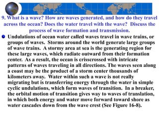
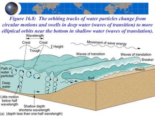
2. Overview
Coastal regions are unique and dynamic
environments. Most of Earth's coastlines are
relatively new and are the setting for continuous
change. The land, ocean, and atmosphere interact to
produce waves, tides, erosional features, and
depositional features along the continental margins.
The interaction of vast oceanic and atmospheric
masses is dramatic along a shoreline. At times, the
ocean attacks the coast with its erosive power; at
other times, the sea breeze, salty mist, and repetitive
motion of the water are gentle and calming.
3. 1. Describe the salinity of seawater: its
composition, amount, and distribution.
Water acts as a solvent, dissolving at least 57 of the elements found in
nature. In fact, most natural elements and the compounds they form
are found in the seas as dissolved solids, or solutes. Thus, seawater is
a solution, and the concentration of dissolved solids is called salinity.
Seven elements comprise more than 99% of the dissolved solids in
seawater: chlorine (Cl), sodium (Na), magnesium (Mg), sulfur (S),
calcium (Ca), potassium (K), and bromine (Br). Seawater also
contains dissolved gases (such as carbon dioxide, nitrogen, and
oxygen), solid and dissolved organic matter, and a multitude of trace
elements. Salinity worldwide normally varies between 34% and 37%;
variations are attributable to atmospheric conditions above the water
and to the quantity of freshwater inflows. The term brine is applied to
water that exceeds the average of 35% salinity, whereas brackish
applies to water that is less than 35%. (See figure 16.2).
4. Figure 16.2: Variation in Ocean Salinity and Latitude. Salinity (green line) is
principally a function of climatic conditions. Specifically, important is the moisture
relation expressed by the difference between evaporation and precipitation (E-P).
5. 2. Analyze the latitudinal distribution of salinity
shown in Figure 16-2. Why is salinity less along the
equator and greater in the subtropics?
Generally, oceans are lower in salinity near landmasses, because of
river discharges and runoff. Extreme examples include the Baltic Sea
(north of Poland and Germany) and the Gulf of Bothnia (between
Sweden and Finland), which average 10% or less salinity because of
heavy freshwater runoff and low evaporation rates. On the other
hand, the Sargasso Sea, within the North Atlantic subtropics, averages
38%, and the Persian Gulf is at 40% as a result of high evaporation
rates in an almost-enclosed basin. Deep pockets near the floor of the
Red Sea register a very salty 225%. In equatorial water, precipitation
is high throughout the year, diluting salinity values to slightly lower
than average (34.5%). In subtropical oceans–where evaporation rates
are high due to the influence of hot, dry subtropical high-pressure
cells–salinity is more concentrated, increasing to 36.5%.
6. 3. What are the three general zones relative to physical structure
within the ocean? Characterize each by temperature, salinity,
dissolved oxygen, and dissolved carbon dioxide.
The ocean's surface layer is warmed by the Sun and is wind-driven.
Variations in water temperature and solutes are blended rapidly in a
mixing zone that represents only 2% of the oceanic mass. Below this
is the thermocline transition zone, a region of strong temperature
gradient that lacks the motion of the surface. Friction dampens the
effect of surface currents, with colder water temperatures at the lower
margin tending to inhibit any convective movements. Starting at a
depth of 1-1.5 km (0.62-0.93 mi) and going down to the bottom,
temperature and salinity values are quite uniform. Temperatures in
this deep cold zone are near 0°C (32°F); but, due to its salinity,
seawater freezes at about –2°C (28.4°F). The coldest water is at the
bottom except near the poles, where cold water may be near or at the
surface. (See Figure 16-3).
8. 4. What are the key terms used to describe
the coastal environment?
The coastal environment is called the littoral zone.
(Littoral comes from the Latin word for shore.) The
littoral zone spans both land and water. Landward,
it extends to the highest water line that occurs on
shore during a storm. Seaward, it extends to the
point at which storm waves can no longer move
sediments on the seafloor (usually at depths of
approximately 60 m or 200 ft). The specific contact
line between the sea and the land is the shoreline,
and adjacent land is considered the coast. (See
Figure 16-4).
9. Figure 16.4: The Littoral Zone. The littoral zone includes
the coast, beach, and nearshore environments.
10. 5. Define mean sea level. How is this value determined?
Is it constant or variable around the world?
Mean sea level is a calculated value based on
average tidal levels recorded hourly at a given site
over a period of years. Mean sea level varies
spatially from place to place because of ocean
currents and waves, tidal variations, air temperature
and pressure differences, and ocean temperature
variations.
11. 6. What interacting forces generate the
pattern of tides?
Earth's orientation to the Sun and the Moon (astronomical
relationships) produce the pattern of tides, the complex
daily oscillations in sea level that are experienced to varying
degrees around the world. Tides also are influenced by the
size, depth, and topography of ocean basins, by latitude, and
by shoreline configuration. Tides are produced by the
gravitational pull exerted on Earth by both the Sun and the
Moon. Although the Sun’s influence is only about half that
of the Moon (46%) because of the Sun's greater distance
from Earth, it is still a significant force. Figure 16-6
illustrates the relationship among the Moon, the Sun, and
Earth and the generation of variable tidal bulges on opposite
sides of the planet.
12. Figure 16.6 The Cause of Tides.
Gravitational relations of Sun,
Moon, and Earth combine to
produce the tides. Gravity and
inertia are essential elements in
understanding tides. Gravity is the
force of attraction between two
bodies. Inertia is the tendency of
objects to stay still if motionless or
to keep moving in the same
direction if in motion. In the case of
figure 16.6a for example, the
corresponding tidal bulge on the
Earth’s opposite side is primarily the
result of farside water’s remaining in
position (being left behind) because
its inertia exceeds the gravitational
pull of the Moon and Sun.
13. Do tides really move in and out along the shoreline?
Tides appear to move in and out along the shoreline,
but they do not actually do so. Instead, the Earth’s
surface rotates into and out of the relatively “fixed”
tidal bulges as Earth changes its position in relation
to the Moon and Sun. Hence, every day, most
coastal locations experience two high (rising) tides,
known as flood tides, and two low (falling) tides,
known as ebb tides. The difference between
consecutive high and low tides is considered the
tidal range.
14. 7. What characteristic tides are expected during a new Moon
or a full Moon? During the first-quarter and third-quarter
phases of the Moon?
Figure 16-6a shows the Moon and the Sun in conjunction
(lined up with Earth–new Moon or full Moon), a position in
which their gravitational forces add together. The combined
gravitational effect is strongest in the conjunction alignment
and results in the greatest tidal range between high and low
tides, known as spring tides. Figure 16-6b shows the other
alignment that gives rise to spring tides, when the Moon and
Sun are at opposition. When the Moon and the Sun are
neither in conjunction nor in opposition, but are more-or-
less in the positions shown in c and d (first- and third-
quarter phases), their gravitational influences are offset and
counteract each other somewhat, producing a lesser tidal
range known as neap tide.
15. 8. Is tidal power being used anywhere to generate electricity? Explain
briefly how such a plant would utilize the tides to produce electricity.
Are there any sites in North America? Where are they?
The fact that sea level changes daily with the tides suggests an opportunity
that these could be harnessed to produce electricity. The bay or estuary
under consideration must have a narrow entrance suitable for the
construction of a dam with gates and locks, and it must experience a tidal
range of flood and ebb tides large enough to turn turbines, at least a 5 m
range. Tidal power generation is possible at about 30 locations in the world,
although at present only two of them are actually producing electricity: an
experimental 1 megawatt station in Russia at Kislaya-Guba Bay, on the
White Sea, since 1969; and a facility in the Rance River estuary on the
Brittany coast of France since 1967.
According to studies completed by the Canadian government, the present
cost of tidal power at ideal sites is economically competitive with that of
fossil fuels, although certain environmental concerns must be addressed.
Among several favorable sites on the Bay of Fundy, one plant is in
operation. The Annapolis Tidal Generating Station was built in 1984 to test
electrical production using the tides. Nova Scotia Power Incorporated
operates the 20 megawatts plant.
16. 9. What is a wave? How are waves generated, and how do they travel
across the ocean? Does the water travel with the wave? Discuss the
process of wave formation and transmission.
Undulations of ocean water called waves travel in wave trains, or
groups of waves. Storms around the world generate large groups
of wave trains. A stormy area at sea is the generating region for
these large waves, which radiate outward from their formation
center. As a result, the ocean is crisscrossed with intricate
patterns of waves traveling in all directions. The waves seen along
a coast may be the product of a storm center thousands of
kilometers away. Water within such a wave is not really
migrating but is transferring energy through the water in simple
cyclic undulations, which form waves of transition. In a breaker,
the orbital motion of transition gives way to waves of translation,
in which both energy and water move forward toward shore as
water cascades down from the wave crest (See Figure 16-8).
17. Figure 16.8: The orbiting tracks of water particles change from
circular motions and swells in deep water (waves of transition) to more
elliptical orbits near the bottom in shallow water (waves of translation).
18. 10. Describe the refraction process that occurs when waves reach an
irregular coastline. Why is the coastline straightened?
Generally, wave action is a process that results in coastal
straightening. As waves approach an irregular coast, they
bend and focus around headlands, or protruding landforms
generally composed of more resistant rocks (See Figure 16-
9). Thus, headlands represent a specific point of wave
attack along a coastline. Waves tend to disperse their
energy in coves and bays on either side of the headlands.
This wave refraction (wave bending) along a coastline
redistributes wave energy so that different sections of the
coastline are subjected to variations in erosion potential.
19. Figure 19.9 Coastal Straightening. The process of coastal straightening
is brought about by wave refraction (deflection from a straight path).
Wave energy is concentrated as it converges on headlands.
20. 11. Define the components of beach drift and the longshore current
and longshore drift.
Particles on the beach are moved along as beach drift, or
littoral drift, shifting back and forth between water and land
in the effective wind and wave direction. These dislodged
materials are available for transport and eventual deposition
in coves and inlets and can represent a significant volume.
The longshore current transports beach drift. A longshore
current generates only in the surf zone and works in
combination with wave action to transport large amounts of
sand, gravel, sediment and debris along the shore as
longshore drift. See Figure 16.10.
21. Figure 16.10: Longshore Current and Beach Drift. Longshore
currents are produced as waves approach the surf zone and shallower
water. Longshore and beach drift results as substantial volumes of
material are moved along the shore.
22. 13. What is meant by an erosional coast? What are its features?
The active margins of the Pacific along the North and South American continents
are characteristic coastlines affected by erosional landform processes. Erosional
coastlines tend to be rugged, of high relief, and tectonically active, as expected from
their association with the leading edge of a drifting lithospheric plate. Sea cliffs are
formed along a coastline by the undercutting action of the sea. As indentations are
produced at water level, such a cliff becomes notched, leading to subsequent
collapse and retreat of the cliff. Other erosional forms evolve along cliff-dominated
coastlines, including sea caves, sea arches, and sea stacks. As erosion continues,
arches may collapse, leaving isolated stacks out in the water. The coasts of southern
England and Oregon are prime examples of such erosional landscapes. (Fig. 16-12).
23. 14. What is meant by a depositional coast? What are the features?
Depositional coasts generally are
located near onshore plains of gentle
relief, where sediments are available
from many sources. Such is the case
with the Atlantic and Gulf coastal
plains of the United States, which lie
along the relatively passive, trailing
edge of the North American
lithospheric plate. A spit consists of
sand deposited in a long ridge
extending out from a coast; it partially
crosses and blocks the mouth of a bay.
A classic example is Cape Cod, Mass.
The spit becomes a bay barrier if it
completely cuts the bay off from the
ocean and forms an inland lagoon.
Spits are made up of materials that
have been eroded and transported by
drift; for much sand to accumulate,
offshore currents must be weak. A
tombolo occurs when sand deposits
connect the shoreline with an offshore
island. (Fig 16-13).
24. Figure 16-14, illustrates several of the common approaches: jetties to block
material from harbor entrances, groins to slow drift action along the coast, and
a breakwater to create a zone of still water near the coastline. However,
interrupting the coastal drift that is the natural replenishment for beaches may
lead to unwanted changes in sand distribution downcurrent. In addition,
enormous energy and materials must be committed to counteract the enormous
and relentless energy that nature invests along the coast.
15. How do people modify littoral drift?
25. 16. Describe a beach—its form and composition.
A beach is that place along a coast where sediment is in
motion. Material from the land temporarily resides there
while it is in active transit along the shore. The beach zone
ranges, on average, from 5 m above high tide to 10 m below
low tide, although specific definition varies greatly along
individual shorelines. Beaches are dominated by quartz
(SiO2) because it is the most abundant mineral on Earth,
resists weathering, and therefore remains after other
minerals are removed. A beach acts to stabilize a shoreline
by absorbing wave energy, as is evident by the amount of
material that is in almost constant motion.
26. 17. On the basis of the information in the text,
do you think barrier islands and beaches
should be used for development? If so, under
what conditions? If not, why not?
27. Answer:
Offshore sand bars gradually migrate toward shore as the
sea level rises. Because many barrier beaches evidence this
landward migration today, they are an unwise choice for a
home site or commercial building. Nonetheless, they are a
common choice, even though they take the brunt of storm
energy and actually act as protection for the mainland. The
hazard represented by the settlement of barrier islands was
made graphically clear when Hurricane Hugo (1989)
assaulted South Carolina. Beachfront houses, barrier beach
developments, and millions of tons of sand were swept
away; up to 95% of the single-family homes in Garden City
alone were destroyed.
28. Next Topic: Living Coastal Environments:
Corals, wetlands, salt marshes, and mangroves.
20. How are corals able to construct reefs and islands?
A coral is a simple marine animal with a cylindrical, saclike body;
it is related to other marine invertebrates, such as anemones and
jellyfish. Corals secrete calcium carbonate (CaCO3) from the
lower half of their bodies, forming a hard external skeleton.
Although both solitary and colonial corals exist, it is the colonial
forms that produce enormous structures, varying from treelike
and branching forms to round and flat shapes. Through many
generations, live corals near the ocean's surface build on the
foundation of older corals below, which in turn may rest upon a
volcanic seamount or some other submarine feature built up from
the ocean floor. An organically derived sedimentary formation of
coral rock is called a reef and can assume one of several shapes,
principally, a fringing reef, a barrier reef, or an atoll.
29. 21. A trend in corals that is troubling
scientists, some possible causes.
Scientists are tracking an unprecedented bleaching and dying-off of
corals worldwide. The Caribbean, Australia, Japan, Indonesia, Kenya,
Florida, Texas, and Hawaii are experiencing this phenomenon. The
bleaching is due to a loss of colorful algae from within and upon the
coral itself. Normally colorful corals have turned stark white as the
host coral expels nutrient-supplying algae. Exactly why the coral
ejects its living partner is unknown. Possibilities include local
pollution, disease, sedimentation, and changes in salinity.
Another probable cause is the 1 to 2C° warming of sea-surface
temperatures, as stimulated by greenhouse warming of the
atmosphere. During the 1982-1983 areas of the Pacific Ocean were
warmer than normal and widespread coral bleaching occurred. Coral
bleaching worldwide is continuing as average ocean temperatures
climb higher. (see Figure 16.17 for coral riff distribution).
30. Figure 16.17. Worldwide Distribution of Living Coral
Formations. Yellow patches are areas of prolific reef
growth. The red dotted line marks the limits of coral activity.
31. 22. Why are coastal wetlands poleward of 30° N and
S latitude different from those that are equatorward?
In terms of wetland distribution, salt marshes tend to form north of
the 30th parallel, whereas mangrove swamps form equatorward of
that point. This is dictated by the occurrence of freezing conditions,
which control the survival of mangrove seedlings. Roughly the same
latitudinal limits apply in the Southern Hemisphere. Salt marshes
usually form in estuaries and behind barrier beaches and sand spits.
An accumulation of mud produces a site for the growth of halophytic
(salt-tolerant) plants. Plant growth then traps additional alluvial
sediments and adds to the salt marsh area. Sediment accumulation on
tropical coastlines provides the site for growth of mangrove trees,
shrubs, and other small trees. The adventurous prop roots of the
mangrove are constantly finding new anchorages and are visible
above the water line but reach below the water surface, providing a
habitat for a multitude of specialized life forms. Mangrove swamps
often secure and fix enough material to form islands.