Downloaded 16 times


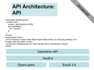
![API Architecture:
Mobile API
Ext.setup({
onReady: function(){
m = new GeoAdminMobile.Map({handedness: 'right',
contextinfo: true,
featureinfo: true
});
var wmts2 = GeoAdmin.layers.buildLayerByName
("ch.bfs.gebaeude_wohnungs_register",
{isBaseLayer: false});
m.map.addLayers([wmts2]);
}
});
GeoAdmin Mobile API
GeoExt Mobile (GXM)
OpenLayers Sencha Touch](https://image.slidesharecdn.com/2012makeopendata-120330012548-phpapp02/85/GeoAdmin-API-Mobile-API-2012-10-320.jpg)


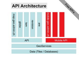
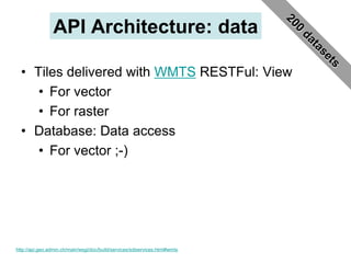
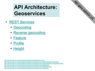
The document discusses the GeoAdmin API, which provides access to Swiss geographic data. It summarizes the key points as follows: 1) The GeoAdmin API makes Swiss geographic data freely available to authorities, private sector, public and academics in accordance with Swiss law requiring sustainable and affordable access. 2) The API provides tile and database access to vector and raster data through RESTful WMTS and database services. It also offers REST geocoding, reverse geocoding, feature, profile and height services. 3) The API architecture supports web, mobile and desktop applications through APIs, libraries and SDKs using open standards like WMTS, REST and open source technologies like OpenLayers, ExtJS and


![Getting Started with Apache Spark: Big Data Made Simple [Free Meetup]](https://cdn.slidesharecdn.com/ss_thumbnails/apachesparkgettingstarted-260203175547-8361bcc3-thumbnail.jpg?width=640&height=640&fit=bounds)


