
More Related Content
Viewers also liked
Similar to Geo-Abstract
Similar to Geo-Abstract (19)
Recently uploaded
Recently uploaded (20)
Geo-Abstract
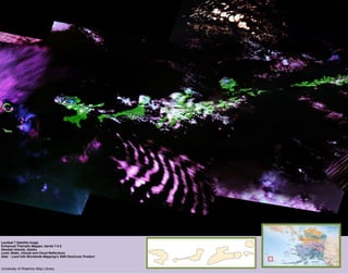
- 1. Alaska Landsat 7 Satellite Image Enhanced Thematic Mapper, bands 7-4-2 Aleutian Islands, Alaska Land, Water, Clouds and Cloud Reflections Data : Land Info Worldwide Mapping’s 2000 GeoCover Product University of Waterloo Map Library
- 2. Landsat 7 Satellite Image Enhanced Thematic Mapper, bands 7-4-2 Libya, Niger and Chad Desert and Water Data : Land Info Worldwide Mapping’s 2000 GeoCover Product University of Waterloo Map Library
- 3. Northern Alberta Landsat 7 Satellite Image Enhanced Thematic Mapper, bands 7-4-2 Peace River, Alberta Data : Land Info Worldwide Mapping’s 2000 GeoCover Product University of Waterloo Map Library
- 4. Digital Elevation Model of Cambridge/Hamilton Area From the Grand River to Burlington Bay Data : Canada Digital Elevation Data Natural Resources Canada University of Waterloo Map Library Legend DEM of Cambridge and Hamilton Area Elevation High : 370 M Low : 75 M Hydrology
- 5. Digital Elevation Model with Enhanced Slope Manitoulin Island /Espanola area Data : Canada Digital Elevation Data Natural Resources Canada University of Waterloo Map Library Elevation Legend DEM of Manitoulin Island area High 490 M Low 180 M