Enhancing Public safety and Security of Crital National INfrasructure Utilizi...
GRASP 2-page Overview - June 2016
1. Global Receive Antenna and Signal Processor Facility
JAMSS America, Inc., 16055 Space Center Blvd., Suite 240, Houston, Texas 77062 USA
grasp@jamssamerica.com • +1 281-461-3700
FACILITY DESCRIPTION
Global Receive Antenna and Signal Processor (GRASP) is an enabling
technology facility that provides for affordable recovery of terrestrial radio
frequency (RF) data using the International Space Station National
Laboratory. Remote RF data is vital to businesses, governments, researchers
and academics for reasons as diverse as tracking ships at sea, studying animal
migrations, improving agricultural yields, and monitoring the health of assets
– and the environment.
GRASP development starts in July 2016 and will be completed in late 2017.
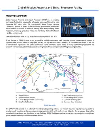
A key feature of GRASP is that it can be used by multiple customers, each targeting unique frequencies of interest (a
representation of this is shown in the graphic below). Placing GRASP on the ISS National Lab vastly increases access to and use
of terrestrial RF signal data. The GRASP commercial facility on the ISS opens access to many worthwhile projects that are
presently not feasible due to limited access to and high cost of recovering terrestrial RF signals using satellites.
GRASP Versatility
The GRASP facility consists of an externally-mounted, nadir-pointing antenna and interally-mounted signal processing facility to
simultaneously condition and process incoming signals in the VHF, UHF, L-, S-, C- and X-bands. The processed data will be
immediately downlinked and distributed to user facilities. GRASP facilitates machine-to-machine communications, providing a
global platform for reception and distribution of data.
2. REPRESENTATIVE APPLICATIONS
Commercial
• Remote asset monitoring and data collection
• Asset tracking
• Weather data collection
• Agricultural monitoring
• Improving cost performance and environmental efficiency of ships
• Confirmation of post-launch CubeSat activation
• ACARS (Aircraft Communications Addressing and Reporting System)
technology demonstrations
• Increasing the TRL (Technology Readiness Level) of new space products and
applications
Scientific and Academic
• Environmental monitoring (e.g. ocean conditions, glacier movements, water
quality, atmospheric studies)
• Wildlife tracking
• Academic studies (student research, academic publications, theses and
dissertations)
Government and Regulatory
• Spectrum studies to identify usage of given frequencies
• Radio propagation studies to identify sources of interference
• Monitoring of vital infrastructure and assets
• Detection of illegal fishing, dumping, trafficking
• Marine environment monitoring
• Homeland security
• Search and rescue
INPUTS SOLICITED
GRASP seeks inputs from users of remotely-collected data to identify user requirements for the GRASP facility. These
inputs will be reflected in the system design to accommodate user requirements to the maximum extent possible. All
inputs received will be kept confidential and will only be used for system design. Aggregated information will be
discussed with the design team, including subcontractors. However, individual survey results will not be disclosed
without the prior written approval of respondants.
FOR MORE INFORMATION
ATTN: GRASP
JAMSS America, Inc.
16055 Space Center Blvd., Suite 240
Houston, Texas 77062 USA
281.461.3700
grasp@jamssamerica.com