1. E X P E R I E N C E Y O U R A M E R I C A ™
Key Observation Points
Inventoried
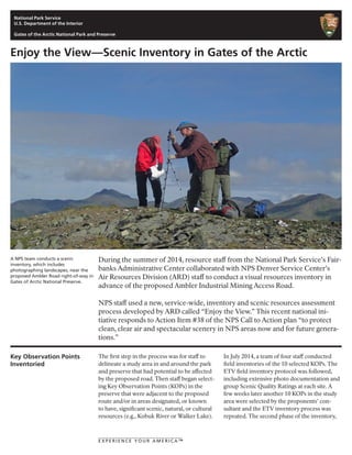
A NPS team conducts a scenic
inventory, which includes
photographing landscapes, near the
proposed Ambler Road right-of-way in
Gates of Arctic National Preserve.
Enjoy the View—Scenic Inventory in Gates of the Arctic
The first step in the process was for staff to
delineate a study area in and around the park
and preserve that had potential to be affected
by the proposed road. Then staff began select-
ing Key Observation Points (KOPs) in the
preserve that were adjacent to the proposed
route and/or in areas designated, or known
to have, significant scenic, natural, or cultural
resources (e.g., Kobuk River or Walker Lake).
In July 2014, a team of four staff conducted
field inventories of the 10 selected KOPs. The
ETV field inventory protocol was followed,
including extensive photo documentation and
group Scenic Quality Ratings at each site. A
few weeks later another 10 KOPs in the study
area were selected by the proponents’ con-
sultant and the ETV inventory process was
repeated. The second phase of the inventory,
During the summer of 2014, resource staff from the National Park Service’s Fair-
banks Administrative Center collaborated with NPS Denver Service Center’s
Air Resources Division (ARD) staff to conduct a visual resources inventory in
advance of the proposed Ambler Industrial Mining Access Road.
NPS staff used a new, service-wide, inventory and scenic resources assessment
process developed by ARD called “Enjoy the View.” This recent national ini-
tiative responds to Action Item #38 of the NPS Call to Action plan “to protect
clean, clear air and spectacular scenery in NPS areas now and for future genera-
tions.”
National Park Service
U.S. Department of the Interior
Gates of the Arctic National Park and Preserve
2. E X P E R I E N C E Y O U R A M E R I C A ™
the View Importance Ratings, were conducted
by a larger team of NPS resource special-
ists and managers in late August 2014, from
which the Scenic Inventory Value and Scenic
Inventory Composite scores were calculated
for each field inventoried viewscape.
In order to utilize our ETV inventory data to
help understand the types, scale, and locations
of impacts from a new road, and in order to
objectively compare alternative route loca-
tions, NPS has been working closely with
interagency partners at Argonne National
Labs to run a series of GIS viewshed analy-
ses. These products include a continuous
surface layer identifying visible areas from all
viewpoints and their associated scenic value
ratings. Composite scores were calculated in
areas with overlapping viewscapes. Additional
GIS analyses are being run to determine those
viewscape areas where the proposed northern
and southern road alignments are visible and
the extent.
The viewpoints are in the new IRMA
ETV database. You can view them here:
https://irma.nps.gov/ETV/Viewpoint/
ListUnitViewpoints/GAAR. You can either
zoom in on the map and click on a point and
click ‘Details,’ or you can go to the scroll down
list below and click on the link of the name
of a viewpoint and click ‘Browse’ to get more
details, site photos, and and find out what we
scored it for View Importance, etc.
Composite Scenic Inventory Values of
21 viewpoints in Gates of the Arctic
National Preserve. Dark red areas
indicate areas with Very High scenic
value ratings and light purple are
rated Moderate-Low scenic values.
For more information on the visual resources
inventory, contact Social Scientist Andrew Ackerman
at (907) 455-0643, or email him at
Andrew_Ackerman@nps.gov.
National Park Service
U.S. Department of the Interior
Gates of the Arctic National Park and Preserve